the Creative Commons Attribution 4.0 License.
the Creative Commons Attribution 4.0 License.
 | 07 Aug 2024
New insights into complex social organization in the southern Caucasus – Late Bronze Age–Early Iron Age settlement patterns in the Shiraki Plain (southeast Georgia)
Levan Losaberidze
Giorgi Kirkitadze
Mate Akhalaia
Mikheil Lobjanidze
Michael Zimmerman
Mikheil Elashvili
Losaberidze, L., Kirkitadze, G., Akhalaia, M., Lobjanidze, M., Zimmerman, M., and Elashvili, M.: New insights into complex social organization in the southern Caucasus – Late Bronze Age–Early Iron Age settlement patterns in the Shiraki Plain (southeast Georgia), E&G Quaternary Sci. J., 73, 145–158, https://doi.org/10.5194/egqsj-73-145-2024, 2024.
Due to its location between Mesopotamia and the Eurasian steppes, the southern Caucasus occupies a distinctive place in Old World archeology. While several local areas in the South Caucasus have shown a complex social organization with fortified structures during the Late Bronze Age and Early Iron Age (LBA–EIA), the Shiraki Plain (southeast Georgia), despite its immense potential, has yet to be examined in a regional context. The presented research aims to conduct an initial multi-stage landscape archeological survey over the Shiraki Plain in order to reveal the LBA–EIA fortified settlements of previously identified Didnauri and Nazarlebi types. The authors use remote sensing, photogrammetry, and terrestrial survey methods to investigate selected areas. The results demonstrate the density and complexity of the massive, fortified structures spread over both the plain and neighboring ridges. Their spatial distribution suggests the idea of a well-organized defensive system adapted to the landscape, which in turn is discussed in a broader regional context.
Aufgrund seiner Lage zwischen Mesopotamien und den eurasischen Steppen besitzt der südliche Kaukasus einen besonderen Platz in der Archäologie der Alten Welt. Während aus verschiedenen Gebieten des südlichen Kaukasus eine komplexe soziale Organisation mit befestigten Strukturen während der Spätbronze- und Früheisenzeit bekannt ist, wurde die Shiraki-Hochebene (Südostgeorgien) trotz ihres hohen Potenzials bisher nicht in einem regionalen Kontext untersucht. Diese Studie präsentiert daher eine erste mehrstufige landschaftsarchäologische Untersuchung der Shiraki-Hochebene, welche Einblick in das räumliche Muster spätbronzezeitlicher befestigter Siedlungen des Didnauri und Nazarlebi-Typs geben möchte. Hierfür haben wir fernerkundliche, photogrammetrische und terrestrische Untersuchungsmethoden zur Untersuchung ausgewählter Gebiete genutzt. Die Ergebnisse zeigen ein dichtes und komplexes Muster massiver befestigter Strukturen, welche über die gesamte Hochebene sowie über benachbarte Höhen verteilt sind. Deren räumliche Verteilung legt ein gutorganisiertes und an die landschaftliche Situation angepasstes Verteidigungssystem nahe, welches in einem breiteren räumlichen Kontext diskutiert wird.
- Article
(9911 KB) - Full-text XML
- BibTeX
- EndNote


Since the Paleolithic period, the southern Caucasus has been at the crossroads of Eurasian human activities and civilizations (Lordkipanidze et al., 2005; Sagona, 2017; Smith, 2006). Accordingly, the region also saw intensive settlement activities during the Late Bronze Age–Early Iron Age (LBA–EIA), i.e., the 2nd and 1st millennia BCE: “In [...] southern Georgia, we see an unequivocal expression of socio-political complexity and centralisation in the form of fortresses” (Sagona, 2017). As this statement suggests, some regions in the southern Caucasus present LBA–EIA cultural landscapes which show the signs of complex social organization and early state formation, such as settlement hierarchy, sedentism, urbanism, agriculture, craft specialization, and social stratification (Erb-Satullo et al., 2019).
This advanced social organization was reflected in innovations in metallurgy to the point that the region has been called the “Caucasian Metallurgical Province” by a number of scholars (Sagona, 2017). Copper and iron metalworking centers became highly specialized in producing the finest items that were in great demand, and this technology played a significant role in this epoch (Sagona, 2017).
While several local areas of this period in the southern Caucasus have been intensively studied and the results placed into a larger regional context (Badalyan et al., 2008; Erb-Satullo et al., 2019; Erb-Satullo and Jachvliani, 2022; Greene and Lindsay, 2012), the Shiraki Plain in southeast Georgia remains a woefully understudied region in the archeology of the southern Caucasus (Fig. 1). The Shiraki Plain is a naturally isolated micro-landscape that geographically dominates the surrounding area. Despite its still fragmentarily studied (geo-)archeological context (Arnhold et al., 2021; Pitskhelauri, 2020; von Suchodoletz et al., 2022), it demonstrates significant potential in the study of LBA–EIA political landscapes and their paleoenvironmental context.

Figure 1Map of the South Caucasus indicating the study area within a red rectangle, along with other LBA–EIA archeological groups discussed in the article. In the lower right corner is the grid laid across the study area of the Shiraki Plain.
The archeology of the Shiraki Plain, besides the traditional excavations, has been studied through aerial and pedestrian surveys, which consisted of three main phases.
-
Phase 1. Because this territory was used as a Soviet air force base, it was not really accessible to scholars until the end of the 1980s when the collapse of the Soviet regime led to more public access to the area. This circumstance also made available the archives of military maps and aerial photographs for archeologists and resulted in the discovery of unknown anthropogenic features on the Shiraki Plain. As a result of early attempts at aerial survey in the 1990s, a few archeological sites have been identified, but this effort was not systematic and remote sensing methods had not yet been adopted (Maisuradze and Mindiashvili, 1999).
-
Phase 2. Another series of surveys in the early 2000s located nearly a hundred sites over the plain. These consisted, however, mostly of highly visible mounds, since these investigations were entirely performed as pedestrian survey (Varazashvili and Pitskhelauri, 2011).
-
Phase 3. The following decade was marked by employing Geographic Information System (GIS) studies and remote sensing approaches based on satellite and aerial imagery. Therefore, further discoveries came to light during this phase (Pitskhelauri, 2018).
When the first investigations began back in the 1990s (Furtwängler et al., 1998), the idea that the Shiraki Plain contained some fortified complexes arose immediately. Unfortunately, it did not receive a great deal of attention at that time because in the following years, a group of massive and complex fortified structures was found at Udabno (Bertram and Bertram, 2012), northwest of Shiraki, through military aerial photographs. Hence, subsequently, the attention of Georgian archeologists shifted towards that area. However, the latest phase of the research at Shiraki has found such fortified structures, and theories about early state formation in this area returned (Pitskhelauri, 2020). Over the past few years, archeological excavations have focused on two sites – Didnauri and Nazarlebi – both of which (Fig. 2) were initially surveyed and mapped using remote sensing techniques (Bukhrashvili et al., 2018, 2019; Pitskhelauri, 2018; Varazashvili and Pitskhelauri, 2011). Both Late Bronze Age–Early Iron Age sites provided valuable archeological material. Didnauri and Nazarlebi are considered typical examples of two main groups of settlements in the Shiraki Plain. Didnauri represents the plain fortresses, while Nazarlebi constitutes a more common hillfort settlement type. This significant context motivated us to further extend our studies by covering a larger area of the plain.

Figure 2Distribution of archeological sites over the Shiraki Plain, including archeological sites discovered via aerial survey, shown in light blue.
This study introduces for the first time a multidisciplinary approach to the study of the archeology of the Shiraki Plain. It includes a multi-stage archeological survey that mainly involved remote sensing and GIS technologies. These results have been partially ground-truthed by the archeological excavations conducted at Didnauri and Nazarlebi, which allows us to discuss our findings in a broader regional context. Although the chronological sequence of the LBA–EIA sites of Shiraki is not entirely clear due to the lack of secure radiocarbon ages, based on an analysis of the archeological materials, the cultural landscape of these sites seems to roughly correspond to the period between the 14th and 9th centuries BCE (Bukhrashvili et al., 2018, 2019; Pitskhelauri, 2018).
The goals of our study were (i) to advance scientific knowledge about the area of the Shiraki Plain as an example of the emergence of complex social organizations in the South Caucasus, (ii) to understand human–landscape interactions in Shiraki in order to demonstrate the complexity of fortified sites and their role in the socio-spatial organization of LBA–EIA societies, and (iii) to discuss Shiraki Plain in a larger regional context and show its significance within the larger region.
The Shiraki Plain in southeastern Georgia is an endorheic basin with a catchment of about 300 km2 and extends between ca. 41°18′ and 41°27′ N and 46°11′ and 46°30′ E at altitudes between 550 and 650 m a.s.l. (above sea level). To the west, south, and north the plain is surrounded by low mountain ridges reaching up to 970 m a.s.l. The Shiraki Plain forms part of the Kura fold-and-thrust belt that consists of a series of south-vergent faults and thrusts. These are composed of deformed Pio-Pleistocene flysch to molasse sediments consisting of conglomerates, sands, loams, clays, and sandstone (Forte et al., 2010; Gamkrelidze, 2003). The climate of the plain is continental semi-arid, with mean temperatures ranging between ca. −4 °C in January and ca. 23 °C in July and mean annual precipitation being around 490 mm (Furtwängler et al., 1998). The plain surface is covered by Vertisols (Matchavariani, 2019) and currently shows xerophytic steppe vegetation, but large parts are used for intensive agriculture of wheat and sunflowers today (Furtwängler et al., 1998). Permanent surface water is currently largely missing, and seasonal creeks descend from the slopes, but a paleolake with an extension of several square kilometers existed in the central plain during the LBA–EIA period (von Suchodoletz et al., 2022). Due to this current lack of permanent surface water resources the plain is largely devoid of settlements, and only in the northern part are some larger villages located.
We applied a multi-stage survey methodology. This approach integrates different spatial scales and consisted of (a) an analysis of the total study area by open-source satellite imagery and mid-range aerial photographs; (b) the application of close-range aerial photogrammetry, with the resolution of few centimeters, to smaller selected sub-areas; (c) a terrestrial survey of areas of special interest; and (d) the integration, analysis, and presentation of the data in the GIS database. Our survey has focused primarily on non-invasive remote sensing techniques, while traditional excavations at the sites Didnauri and Nazarlebi were performed by other teams (Bukhrashvili et al., 2018, 2019, 2020; Pitskhelauri, 2018).
Our study area encompassed a 40 km × 20 km grid that was laid across the entire plain, in which each square covered 4 km2 or 2 km × 2 km (Fig. 1).
For (a), during the first stage, encompassing the total study area, the following satellite images and mid-range aerial photos were analyzed: 20 cm resolution monochrome aerial photos from the land cadaster project of Georgia (photos taken in the year 2000); ASTER 10 m resolution multispectral satellite images; and Google Earth, Bing, and Azersky/SPOT6 satellite imagery. All images were georeferenced in UTM projection (Zone 38) and processed in ArcMap 10.4.1 by means of visual inspection of the surface cover (mostly vegetation). The Shiraki Plain almost completely lacks any kind of tree cover or forest canopy. Hence it provides beneficial conditions to observe changes in the vegetation color, which itself has a significant correlation to soil composition and is linked to subsurface conditions.
These investigations revealed around 30 new possible archeological sites across the Shiraki Plain (Fig. 2), which is a significant number considering two factors – the scale of the study area and the circumstance that these sites could not be found by previous field investigations (Varazashvili and Pitskhelauri, 2011). The detected sites have been named using the acronym SSP (Shiraki Survey Project) and a sequentially running number (i.e., 1400, 1401, etc.). Each 4 km2 (2 km × 2 km) survey grid was subdivided in turn into 100 m × 100 m sub-squares (1 ha). Each identified site covers around 10 to 25 sub-squares, which demonstrates the possible size of these settlements.
For (b), at the second stage, 102 of these 1 ha sub-squares were selected and subsequently photographed from an uncrewed aerial vehicle (UAV). The aerial photos were processed using photogrammetric techniques, yielding ultra-high-resolution orthographic images and digital elevation models (DEMs) of the studied sites. These provided high-resolution RGB images of the surface, as well as detailed models of the terrain at sub-decimeter (< 10 cm) resolution and with absolute vertical errors in a range of 10–30 cm and relative horizontal errors of < 10 cm. For this purpose, Agisoft Metashape software was applied (https://www.agisoft.com, last access: 23 July 2024). These high-resolution data allowed us to delineate visible features and sometimes even to make preliminary conclusions about the architectural and functional details of each site.

Figure 3Map highlighting two types of archeological sites in the Shiraki environment: the Didnauri and Nazarlebi types. Red arrows indicate the main approaches to the Shiraki Plain.
For (c), at the third stage, to retrieve more information on plain settlements, three additional sites (numbers SSP1405, SSP1406, and SSP1408) other than Didnauri were selected for a comprehensive pedestrian survey, based on the promising results from the aerial survey, i.e., clear visibility of the structures. The design of this field survey involved 50 m long transects executed by four individuals at 10 m intervals (i.e., 100 m2 walked twice). Each surveyor carried a counter and recorded the quantity of pottery sherds, lithics, and building materials (stones), from which only a limited number of diagnostics were collected. The density distribution of each type of archeological material was evaluated and mapped, providing additional parameters for spatial analysis (Tartaron, 2003). The locations of building materials (stones) were particularly important, as the Shiraki Plain consists of large arable fields underlain by massive clay deposits which do not contain stones naturally (von Suchodoletz et al., 2022).
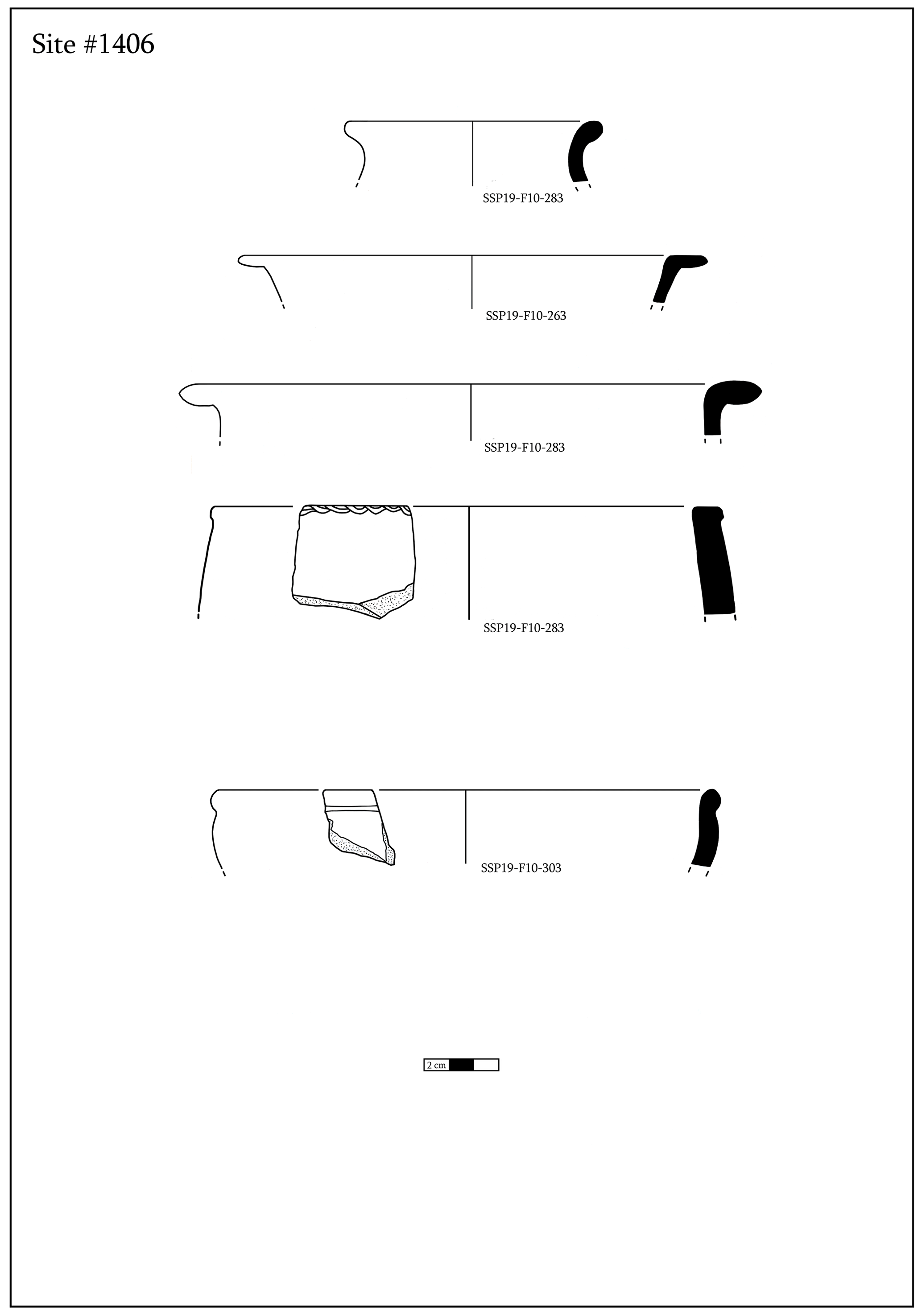
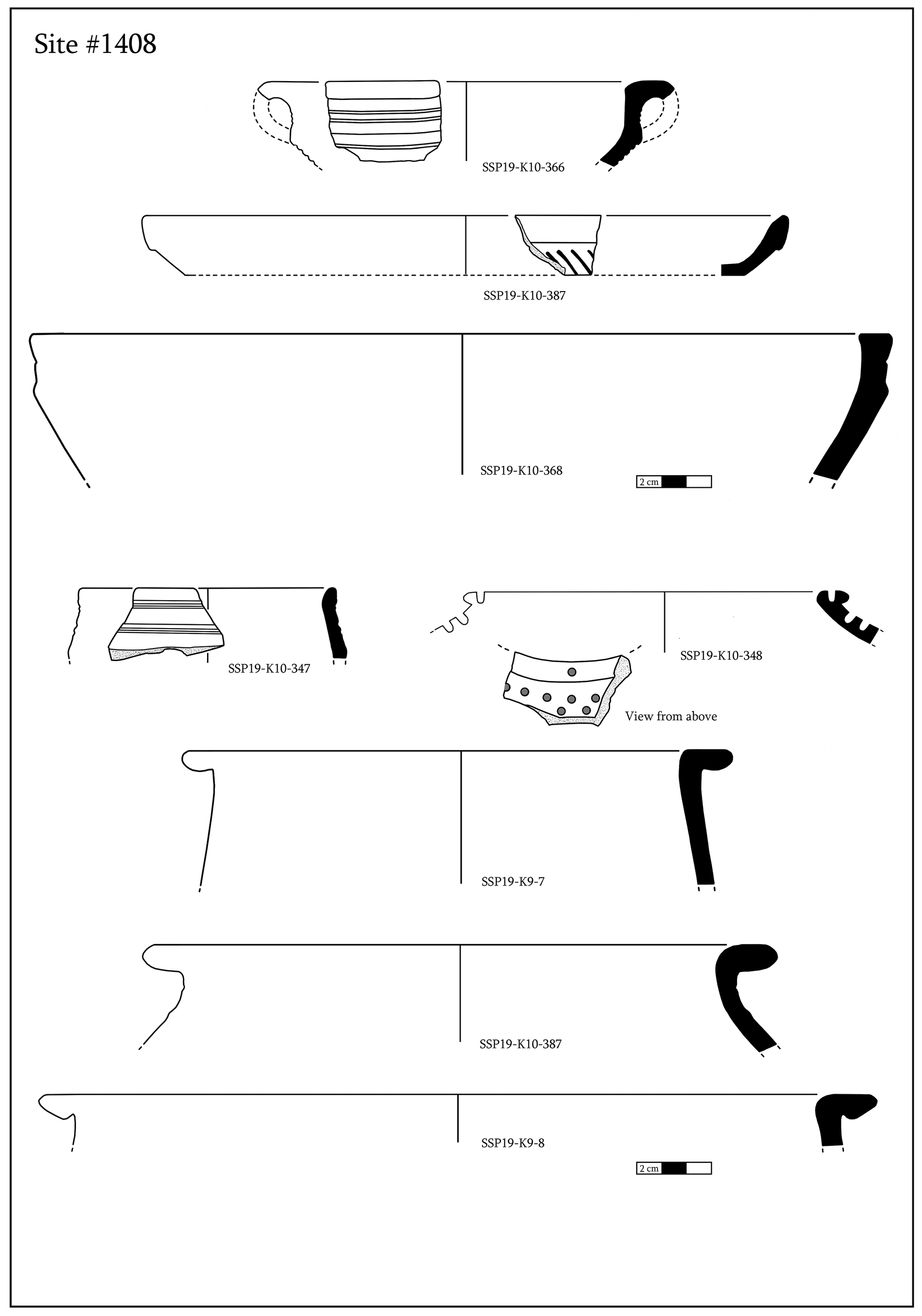
In terms of the limited number of diagnostic materials collected during the field survey, several factors must be taken into consideration: first, the fields of the Shiraki Plain have been actively plowed, resulting in a great deal of out-of-context surface material; second, again due to intensive cultivation, surficial archeological material is highly fragmented, and often it is impossible to derive information other than the type of material; and third, the surveys were limited in personnel, resources, and the storage capacity required to handle a large number of samples. This approach, however, has not restricted us from establishing site types and periodization of the surveyed archeological sites. On some occasions informative artifacts were also found, which are illustrated in more detail below (Figs. 7–9).
Table 1Table illustrating the settlements of the Didnauri type identified over the Shiraki Plain.

Table 2Table illustrating the settlements of the Nazarlebi type identified over the hills surrounding the Shiraki Plain.
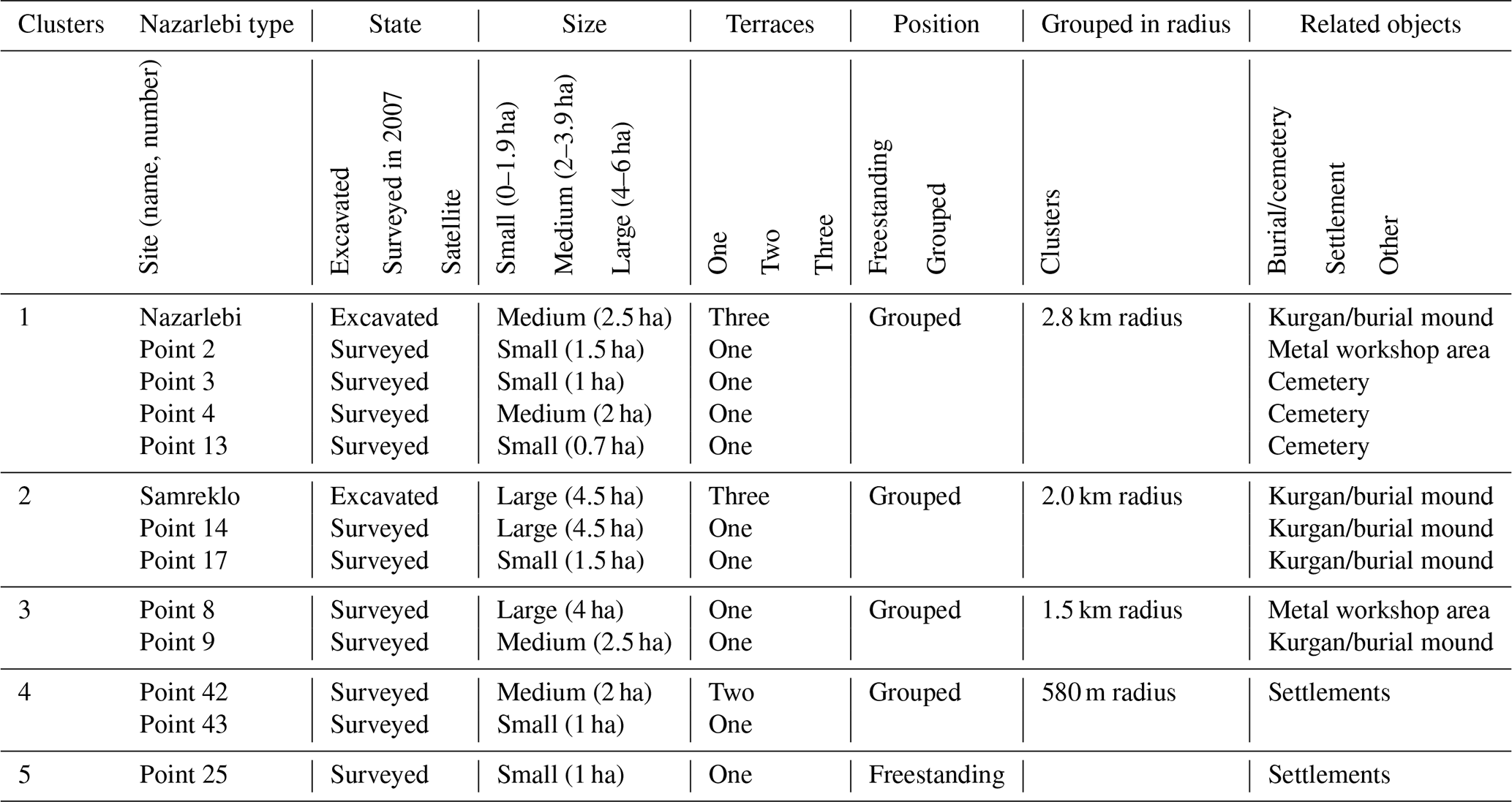

Figure 4Viewshed map of the Shiraki settlements, with areas visible from the highlighted point(s): (a) freestanding hillfort 25 overlooks the Alazani river valley (northern flank); (b) the sites of Samreklo, 14, and 17 cover the northwestern entrance; (c) sites 3, 4, and 13 cover the southwestern entrance; (d) viewshed from the Nazarlebi central hillfort, overlooking the entire Shiraki Plain and having visual contact with nearby sites 8, 9, 42, and 43; (e) sites 8 and 9; (f) sites 42 and 43 control the southern entrance; (g) viewshed from the Didnauri central fortress, covering all the hillforts; (h) cumulative viewshed, with color reflecting the number of plain fortresses that the given point is visible from.
For (d), GIS software (ArcMap) was used to incorporate the collected geo-referenced data into a single geodatabase and merge it with the background layers, such as an ASTER 30 m digital elevation model (https://lpdaac.usgs.gov/news/nasa-and-meti-release-aster-global-dem-version-3, last access: 23 July 2024) and Soviet era topographic maps of 25 000 and 50 000 scale. The DEM provided additional capabilities for spatial analyses, such as hillshade (highlighting elevation variations within the landscape) and hypsometry (measuring the elevation of features relative to sea level). Additionally, viewshed analysis (analyzing the area that is visible from a given location) was conducted (Wheatley, 1995). Two digital elevation models were used for calculation. The first was the ASTER 30 m DEM and the second the 10 m resolution DEM derived from the digitization and interpolation of 25 000 scale Soviet period topographic maps.
The multi-stage survey described above has resulted in a typology of the sites, revealing material distribution and chronology, their spatial organization, and an overall picture of the larger Shiraki area.
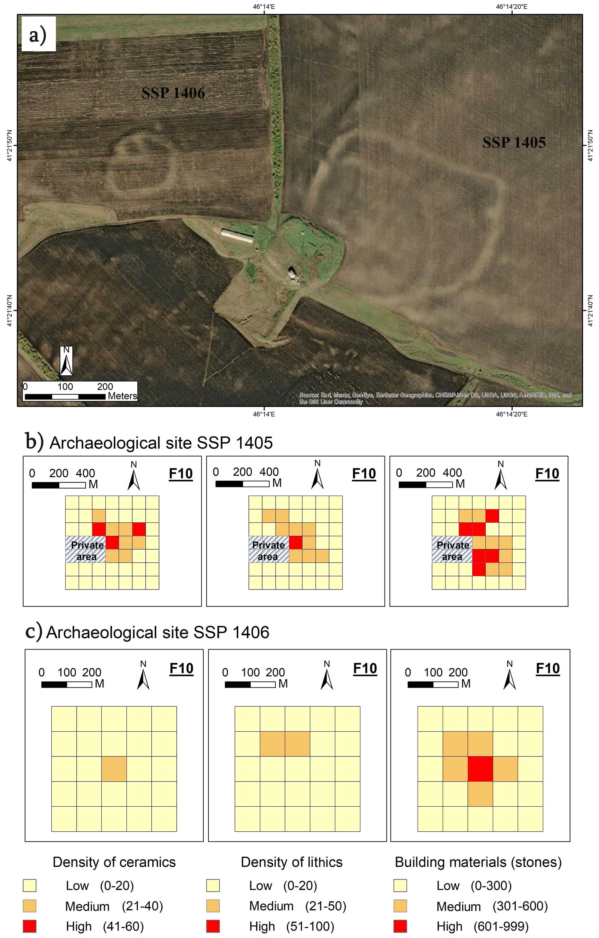
Figure 5(a) Archeological sites SSP1405 (on the right) and SSP1406 (on the left). (b) Density of ceramics (first), lithics (second), and building materials (third) across the site SSP1405. (c) Density of ceramics (first), lithics (second), and building materials (third) across the site SSP1406.

Figure 6(a) Aerial image of the archeological site SSP1408. (b) Density of ceramics (first) and building materials (second) across the site SSP1408.
4.1 Site typology based on the GIS study
By combining the data from stages (a) and (b), more than 100 sites have been confirmed over the plain. More than 70 % (77 sites) of these were discovered by earlier studies (Varazashvili and Pitskhelauri, 2011) and consisted mostly of highly visible mounds (such as Nazarlebi, Tsiskaraant Gora, and Usakhelo Gora), while the remaining about 30 % of sites (22 sites) were only found by applying remote sensing techniques (Fig. 2). Here, we present only 22 sites within the two main fortification types – Didnauri (plain fortresses) and Nazarlebi (hillforts). The rest of the mentioned > 100 sites constitute other types of archeological sites, such as burials, possible metal workshop areas, and small settlement mounds.
This dataset reveals that these 22 LBA–EIA settlements include 9 sites within Didnauri-type plain fortresses and 13 sites within Nazarlebi-type hillforts. Although the term “fortress” is sometimes used in the literature to describe any type of LBA fortified settlement, whether it is a hillfort or another type, we separate “plain fortress” and “hillfort” to demonstrate the difference between the types of the sites.
Plain fortresses, or “Didnauri-type” structures, are located on the lower part of the plain and are not expressed on the terrain surface (Fig. 3), wherein the shapes of the underground structures can only be seen from above mostly by color differences in vegetation. This type consists of several clusters of two to three close-standing fortresses. However, two of the sites (Didnauri and SSP1408) are located separately from those clusters, so they are freestanding fortresses; therefore, they may be considered as independent groupings of structures. Didnauri-type sites are clustered into four groups within a 5 km distance of each other. These groups are scattered across an 8 km radius, basically in the central part of the plain. The fortresses are of varying sizes, with the largest one taking up an area of 14 ha and the smallest one taking up an area of 1 ha (Table 1).
While each site has unique features clearly related to the local terrain conditions, they also have a number of common features found in fortification structures, such as an outer defensive ditch, outer wall, inner ditch, and citadel.
It must be noted that the site SSP1408 studied in this article differs from typical Didnauri-type settlements because of its placement on elevated terrain in the center of the plain, but by its location and planning, we attribute it to the same class of plain fortresses.
The hillforts, or “Nazarlebi-type” structures, are spread over the surrounding mountain ridges, which provide natural protection and control over the surrounding areas. Geographically, most of those hillfort sites are concentrated on the ridges towards the southwestern end of the plain, but several are also diffused over the north-northwestern slopes. Nearly 50 such sites are located over the ridges; of these 13 have been identified as hillforts, and the rest are small settlements, workshop areas, or burials. The hillfort sites are represented by a series of large artificial terraces. Our observation has identified hillforts mainly with one, two, or three terraces. They are also clustered into six groups with a 4–5 km distance between each group on the southwestern ridge of the plain. Only one freestanding hillfort has a distant location at the northern ridge and sits some 13 km east of the closest cluster (Table 2, Fig. 3).

4.2 Viewshed analysis
Understanding human–landscape interactions in Shiraki was one of our objectives that, in this context, was addressed to demonstrate the complexity of hillfort sites and their role in the socio-spatial organization of LBA–EIA societies. Our viewshed analysis yielded some interesting results. However, it should be stated that the accuracy of the method is solely based on a digital elevation model. Hence, while calculating viewsheds we cannot consider a number of realistic factors that could have been a barrier for the viewer, such as weather and vegetation conditions and the physical ability of a person who controls the area. Therefore, when taking these results into account, they should be considered as taking place under ideal circumstances (Paz and Birkenfeld, 2017).
The ridges that enclose the Shiraki Plain show altitudes of around 700–900 m, while the lowland in the central plain where the plain fortresses are distributed shows an elevation of about 550–650 m. The total length of the ridges enclosing the plain is 80 km, while the southern ridge covers some 30 km distance, and the longest chain of the hillforts, which has been observed on this ridge, is 20 km long, including Nazarlebi and sites numbered 2, 3, 4, 8, 9, 13, 42, and 43. Closer observation of the visibility patterns for the hillfort sites suggests that they form a chain that overlooks large territories within the plain and outside of it and control the approaches mostly toward the western and southern edges of the plain (Fig. 4). The group of hillforts consisting of sites Samreklo, 14, and 17 covers the northwestern (main) entrance; the group consisting of sites 3, 4, and 13 covers the southwestern entrance; and the groups consisting of sites 8 and 9 and sites 42 and 43 cover the southern entrance. Freestanding hillfort 25 overlooks the northern flank (the Alazani river valley; see Fig. 3), from where the Shiraki Plain is best protected due to natural terrain. Neighboring hillforts usually overlap their visibility areas. Counting the cumulative viewshed of this entire system of the hillforts in a chain makes nearly a 100 km radius of the visually controlled areas towards the territories outside Shiraki. Viewshed analyses also outlined the strategic location of Didnauri, from where all the hillforts and fortresses discussed in this article are visible. Other fortresses located inside the plain can see immediate neighbors and most of the hillforts, as shown in the collective visibility frequency map calculated for all the plain fortresses (Fig. 4h).
4.3 Terrestrial survey
The Nazarlebi-type hillfort sites, which had been identified in the early 2000s, had already been terrestrially surveyed (Varazashvili and Pitskhelauri, 2011). Therefore, during stage (c) we decided to focus on three newly identified sites of the plain fortresses, representing two rather large areas of fortresses scattered across the lower part of the plain. Sites SSP1405 and SSP1406 are clearly Didnauri type, representing one cluster but having totally different scales. In contrast, site SSP1408, which is also a plain fortress, is structurally different, consisting of a massive freestanding, possibly fortified and highly visible mound with detectable structures.
With 11 ha, site SSP1405 is one of the largest of the Didnauri-type settlements on the plain (with the largest being 14 ha) and has an irregular rectangular shape. It appears to have a defensive ditch around its walls, like the vast majority of the Shiraki settlements do. Also, some internal structures are slightly visible in the aerial images, particularly a curved wall within the main fortification wall, which makes for a more well-defended inner structure (Fig. 5a). Its southwestern part is damaged by an artificial mound, which is later in date, and covers almost 200 m of the long part of the wall. Due to that damage 19 sub-squares were surveyed instead of 25, which revealed a concentration of surface materials in the central area. This site shows a significant number of building stones on the surface which were revealed by intensive plowing, which highlights the massive number of stones used in building these fortresses (Fig. 6b).
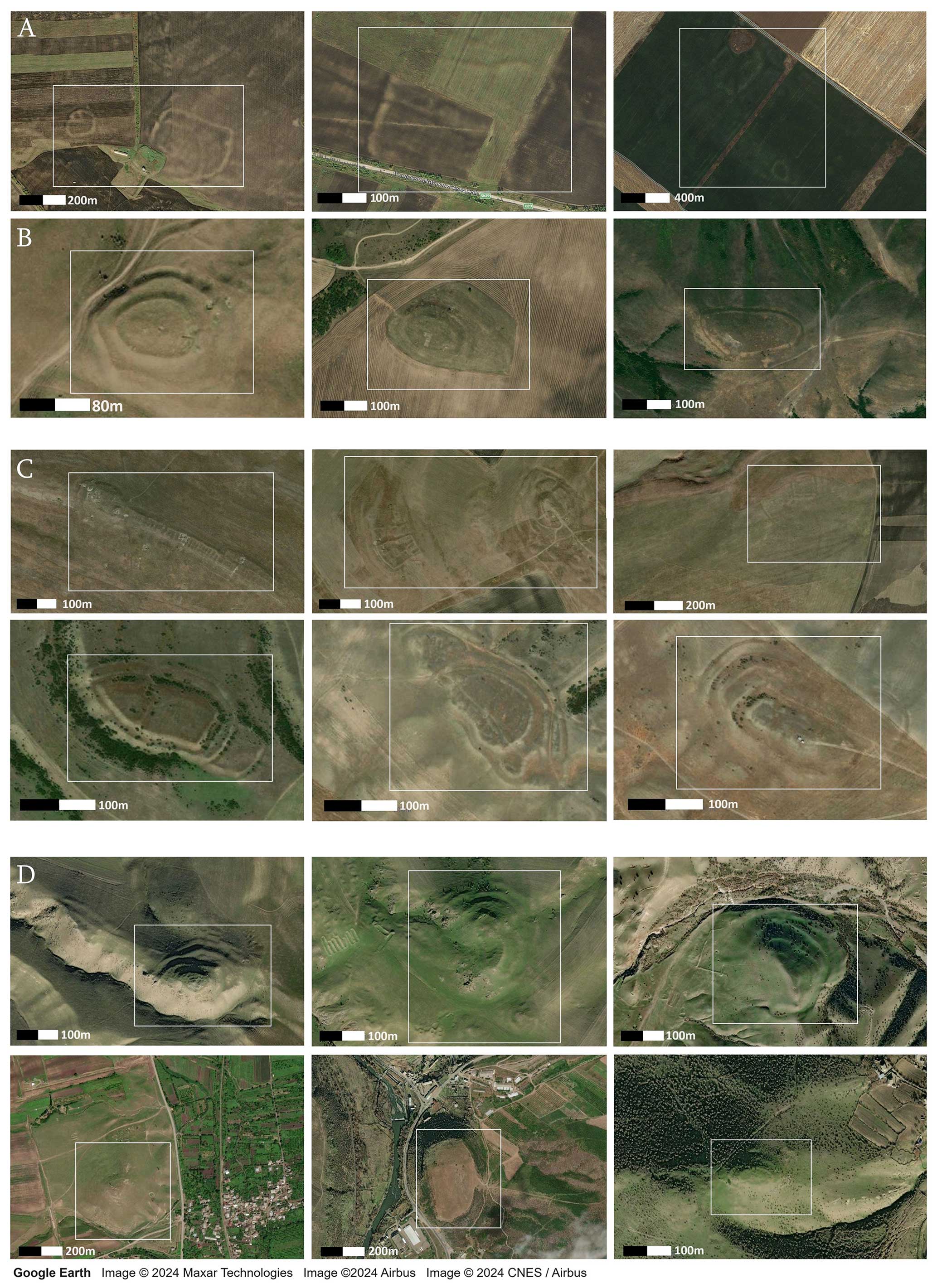
Figure 10Groups of LBA–EIA fortified settlements throughout the South Caucasus: A – Didnauri-type settlements; B – Nazarlebi-type settlements; C – Iori basin (Udabno) settlements; D – Kvemo Kartli settlements.
Site SSP1406, northwest of SSP1405, has a circular shape and is eminently smaller (1.5 ha) than its neighbor. The diameter of site SSP1406 is 120 m. Its internal structure is rectangular and attached to the main wall on the northwest side, as observed in aerial photographs (Fig. 5a). The site covers nine sub-squares of the surface survey and shows a lower density of the materials and building stones than site SSP1405. Building stones in Shiraki vary in dimensions from the size of cobblestones to massive 50 cm length uncut stones. A slightly higher distribution of pottery sherds comes from the central part of the structure (Fig. 5c).
Site SSP1408 shows a relatively different structure of the settlement than the previous two. While the above-mentioned sites are less visible in the landscape, and their contours can only be identified using satellite or aerial imaging, site SSP1408 represents a massive artificial mound with a height of 5 m and a diameter of 200 m. This structure is slightly visible on aerial photographs and in the digital elevation model and suggests a complex structure including a citadel, defensive ditch, and outer wall (Fig. 6).
The surface collection of artifacts at these three sites provided key information about the material culture and chronology of the Shiraki fortified settlements. The diagnostic ceramics are generally dated to the LBA–EIA (Figs. 7, 8, and 9) and consist of cooking pots, jars, and jugs and are decorated in various ways like comb stamping, incision, pinching, impressing, and applying. Common decoration motifs are wheat or conifer shapes, chevrons, concentric lines, and waves. The main pottery types are black- and gray-burnished wares typical of Lchashen–Tsitelgori pottery traditions (Sagona, 2017), and the fabrics of these wares tend to be gray as well, with lime, limestone, quartz, or grit inclusions.
In addition, we should also mention that some significant archeological objects, like a miniature clay wheel, a cornelian bead, a clay stamp seal with an impression of a swastika (a common decorative motif in the Late Bronze Age throughout the Mediterranean and the Caucasus), and a clay bucranium fragment, were found during the field survey at other sites but will not be discussed in detail in this article. Additionally, horned zoomorphic terracotta head figures are common at Shiraki (Hasanov, 2018).
The combination of satellite imagery, close-range aerial photogrammetric mapping, and the surface collection of archeological material provides valuable information on the socio-spatial organization of fortified structures in the southern Caucasus during the LBA–EIA period.
Evidently, the unique environment of the Shiraki Plain, including its terrain (rather separated from surroundings) and its local climatic conditions, has created an isolated cultural landscape upon which fortified settlements of varying sizes and designs were arranged during the LBA–EIA period. Certainly, the hillforts of Nazarlebi type that have emerged on the uplands around the plain were adapted to the landscape that, in general, was advantageous for defensive structures. The chain of the hillforts emphasizes the systematic nature of fortified structures in Shiraki which, because of the geographical advantages given by the bowl-shaped topography of the Shiraki Plain, created the conditions necessary for the formation of complex LBA–EIA social organization.
Regarding the context of the fortresses on the Shiraki Plain, the stark differences in their size may refer to their functional variations within the hierarchically organized lifeways of the LBA–EIA Shiraki Plain. The largest fortresses would have been primary centers, while the smaller fortresses served as their satellites. However, looking at the spatial distribution of these sites in the central lower plain (Figs. 2 and 3), one has to keep in mind that a paleolake existed there at least during later phases of the LBA–EIA period (von Suchodoletz et al., 2022). This means that the significant lack of archeological sites in the central area of the plain could be caused either by missing settlements due to the existence of that waterbody or by formerly existing sites prior to the LBA–EIA period being subsequently covered by lake sediments, a phenomenon also known from floodplains (von Suchodoletz et al., 2020). Although the wave of socio-political changes during the LBA–EIA remains highly debated in the southern Caucasus and seems less clear than in the Near East and Mediterranean regions, the combination and analysis of data from different micro-landscapes of the southern Caucasus allow new insights into the emergence of complex polities in the region (Erb-Satullo et al., 2019; Erb-Satullo and Jachvliani, 2022; Herrmann and Hammer, 2019; Sagona, 2017; Smith, 2006).
Alongside the well-organized consolidation of settlements at Shiraki, closer observation suggests that the southern Caucasus, in general, is covered by complex groupings of similar LBA–EIA fortified systems, with approximately 10–20 settlements concentrated in each group (Fig. 10). One of these groups, with 15 fortified settlements, is located in the Iori basin, near the village of Udabno, about 70 km west of Shiraki and extends over 540 km2 (Fig. 2). A detailed spatial study of this cluster showed three small groups (Babutsidze, 2020) of settlements in one location, which were excavated in the early 2000s (Kunze, 2017). The construction patterns of the Udabno settlements date to the 11th–9th centuries BCE, which, according to Kiazo Pitskhelauri (personal communication, March 2019), find some parallels with late Hittite fortified structures.
Another group of Kvemo Kartli settlements (Figs. 2, 10) consisting of 12 LBA–EIA hillforts stretches over 3000 km2 within the large territory between the Middle Kura Basin (Marneuli–Gardabani plain) to the east and the Javakheti ridge to the west, located in southern Georgia and near the northern border of Armenia, where some significant sites are located, such as Kavakh Tepe and Mtsvane Gora (Erb-Satullo et al., 2019). This group, in turn, is bordered and partially overlapped by widely spread megalithic fortresses, also known as cyclopean fortresses, from the west that cover the large territories of the historic Javakheti and Trialeti regions of southern Georgia and the Kars–Ardahan region in eastern Türkiye (Narimanishvili, 2019; Robinson and Khaburzania, 2020).
We would like to conclude this discussion of various LBA–EIA settlements in the southern Caucasus by highlighting one of the more densely built and well-studied groups of fortified structures in northwestern Armenia. There, the hillforts of the Tsaghkahovit Plain are represented by at least 13 sites (Smith et al., 2009) and distributed over some 1000 km2, beyond the borders of the Tsaghkahovit Plain (Greene and Lindsay, 2012). Gegharot hillfort, one of the significant sites of that region, reveals evidence of the administration of economic and religious activities at the same place (Lindsay and Greene, 2013). In this context, a sanctuary discovered at Nazarlebi hillfort in southwestern Shiraki is also a proper example of how fortified structures not only served a role in the establishment of political and military authority over a region but also incorporated religious functions (Bukhrashvili et al., 2018, 2020) (see Fig. 1).
Several important points should be highlighted based on this regional overview of social organization and geographically concentrated groups of fortresses within the southern Caucasus. First, there is clear evidence that the Shiraki cluster is a cumulative system of fortresses in which landscape diversity results in different types of fortified structures, centralized for the purpose of territorial and socio-political organization. Second, other clusters such as those at Udabno and in the Tsaghkahovit Plain demonstrate complex socio-political practices, unlike the widely and scattered hillforts over the Javakheti–Gardabani area, which suggests no clear relations between the locations.
Furthermore, it is essential to consider broader regional connections and influences. Although there is limited evidence of a regional impact on the development and ascent of complex Late Bronze Age–Early Iron Age organizations in the southern Caucasus, connections to trade relations with more distant Anatolian and Near East polities can be proposed. As Lindsay and Greene (2013) posit, Caucasian metal traders played an active role in this expansive region.
Despite the notion that the Shiraki Plain was likely an isolated cultural landscape in terms of the well-established defensive system and internal sources of water and food, archeological evidence from the settlements and cemeteries of the Shiraki Plain, including metal objects; a variety of beads made of carnelian, paste, or glass; and clay stamp seals, indicates active trade relations into regions beyond this landscape.
Additionally, unlike other regions, the Holocene paleoclimatic conditions of the southern Caucasus with its topographically induced variety of landscapes have not been well established thus far. This is particularly evident in the semi-humid to semi-arid lowlands of the southeastern Caucasus, where Shiraki is located (Bliedtner et al., 2020). These important aspects must be emphasized and developed further.
Summarizing the results from our multi-stage survey at the Shiraki Plain and placing them into a broader regional context provide a more complete picture of the Late Bronze Age–Early Iron Age (LBA–EIA) fortified landscapes in the southern Caucasus. Our study suggests that Shiraki is one of multiple complex polities in the region; however, the Didnauri type of fortresses has not appeared elsewhere yet in the other studied landscapes in the region. Moreover, the Shiraki Plain perfectly demonstrates the adaptation of complex structures to a landscape where hillforts can be more effectively organized along mountain ridges, which produces a chain that controls an extended perimeter and enables communication between the closest forts.
Regional observation suggests several large groups of fortified complexes in the southern Caucasus, where centralization could have been attested in some areas. The theories on the relations of these political formations to neighboring regions like Anatolia and the Near East are based on the emerging evidence of the development of trading throughout these large territories. An extended, multi-disciplinary regional investigation including paleoenvironmental and paleoclimatic studies is warranted to fully answer questions regarding the social complexity of polities and their natural contexts in the southern Caucasus. Further research at the sites on the Shiraki Plain could be an important step in such an investigation, also due to the current lack of radiocarbon dates from these sites.
Spatial data, such as digital elevation models and aerial imagery used in the publication, are available online at no cost. Additional archeological survey data from the publication are available from the authors upon reasonable request.
All authors made substantial contributions to this research. LL, ME, and GK conceived the study. LL, GK, MA, and ML performed the fieldwork. Analyses of field data and aerial imagery were carried out by LL, GK, MA, and ML and supervised by ME and MZ. All the authors contributed to the manuscript draft. LL, MZ, and ME worked on reviews and finalized the manuscript.
The contact author has declared that none of the authors has any competing interests.
Publisher’s note: Copernicus Publications remains neutral with regard to jurisdictional claims made in the text, published maps, institutional affiliations, or any other geographical representation in this paper. While Copernicus Publications makes every effort to include appropriate place names, the final responsibility lies with the authors.
This article is part of the special issue “Quaternary research in times of change – inspired by INQUA Roma 2023”. It is a result of the INQUA conference, Rome, Italy, 14–20 July 2023.
We want to acknowledge the contribution from Kiazo (Konstantine) Pitskhelauri (2024) and Vazha Varazashvili (2014); their prior field archeological surveys in the area laid the bases for the later study conducted by the authors of this paper. We thank Julia Meister, two anonymous referees, and the editors for constructive and insightful comments which significantly helped to improve this paper. We are grateful to chief editor for considering our APC discount application and granting free publication.
This study was financially supported by the Shota Rustaveli Georgian National Science Foundation (SRNSF project no. FR-18-22377) and US National Science Foundation (IRES project no. 1854153).
This paper was edited by Julia Meister and reviewed by two anonymous referees.
Arnhold, S., Bukhrashvili, P., Blocher, F., Tskvitinidze, Z., and Davitashvili, S.: Preliminary Report on the 2021 archaeological works in Dedoplistskaro Municipality conducted by the joint expedition of Tbilisi Ilia State University and Halle Martin Luther University, Amirani, 35, 5–21, 2021.
Babutsidze, S.: Late Bronze-Early Iron Age archaeological sites of the Gardabani plain, Master Thesis, School of Arts and Sciences, Ilia State University, Georgia, 149 pp., 2020.
Badalyan, R., Smith, A. T., Lindsay, I., Khatchadourian, L., Monahan, B., and Hovsepyan, R.: Village, fortress, and town in Bronze and Iron Age Southern Caucasia: A preliminary report on the 2003–2006 investigations of Project ArAGATS on the Tsaghkahovit Plain, Republic of Armenia, Archäologische Mitteilungen Aus Iran Und Turan, 40, 40–105, 2008.
Bertram, G. İ., and Bertram, J.-K.: Udabno – Eine erste Zusammenfassung der Ausgrabungs- und Prospektionsergebnisse nach Abschluss der Feldarbeiten. Austausch Und Kulturkontakt Im Südkaukasus Und Seinen Angrenzenden Regionen in Der Spätbronze-/Früheisenzeit, 87–121, https://www.academia.edu/24669210/Udabno_Eine_erste_Zusammenfassung_der_Ausgrabungs_und_Prospektionsergebnisse_nach_Abschluss_der_Feldarbeiten_Udabno_A_First_Summary_of_the_Excavation_and_Prospection_Results_after_Completion_of_the_Field_Work (last access: 23 July 2024), 2012.
Bliedtner, M., Zech, R., Zech, J., Schäfer, I., and von Suchodoletz, H.: A first Holocene leaf wax isotope-based paleoclimate record from the semi-humid to semi-arid south-eastern Caucasian lowlands, J. Quaternary Sci., 35, 625–633, https://doi.org/10.1002/jqs.3210, 2020.
Bukhrashvili, P., Blocher, F., Kipiani, G., Tskvitinidze, Z., Davitashvili, S., Schultz, J. G., Wollny, B., and Michalik, M. M.: Ausgrabungen in der Wallanlage Nazarlebi, Amirani, 31, 5–27, 2018.
Bukhrashvili, P., Blocher, F., Tskvitinidze, Z., and Davitashvili, S.: Ausgrabungen in Nazarlebi, Kachetien (Georgien) 2017 und 2018, Mitteilungen Der Deutschen Orient-Gesellschaft Zu Berlin, 151, 271–294, 2019.
Bukhrashvili, P., Blocher, F., Tskvitinidze, Z., Davitashvili, S., and Fassbinder, J. W. E.: Ausgrabungen in Nazarlebi, Kachetien (Georgien) 2019, Mitteilungen Der Deutschen Orient-Gesellschaft Zu Berlin, 152, 125–154, 2020.
Erb-Satullo, N. L. and Jachvliani, D.: Fortified Communities in the South Caucasus: Insights from Mtsvane Gora and Dmanisis Gora, J. Field Archaeol., 47, 305–323, https://doi.org/10.1080/00934690.2022.2074647, 2022.
Erb-Satullo, N. L., Jachvliani, D., Kalayci, T., Puturidze, M., and Simon, K.: Investigating the spatial organisation of Bronze and Iron Age fortress complexes in the South Caucasus, Antiquity, 93, 412–431, https://doi.org/10.15184/aqy.2018.191, 2019.
Forte, A. M., Cowgill, E., Bernardin, T., Kreylos, O., and Hamann, B.: Late Cenozoic deformation of the Kura fold-thrust belt, southern Greater Caucasus, Geol. Soc. Am. Bull., 122, 465–486, https://doi.org/10.1130/B26464.1, 2010.
Furtwängler, A. E., Knauß, F., Motzenbäcker, I., Gagošidze, J., and Kvavadze, E.: Archäologische Expedition in Kachetien 1997, Ausgrabungen in Širaki, Eurasia Antiqua: Zeitschrift Für Archäologie Eurasiens, 4, 309–364, 1998.
Gamkrelidze, I. P.: Geological map of Georgia 1:500,000, Georgian State Department of Geology and National Oil Company, SAQNAFTOBI, 2003.
Greene, A. and Lindsay, I.: 4 Mobility, Territorial Commitments, and Political Organization among Late Bronze Age Polities in Southern Caucasia, Archaeological Papers of the American Anthropological Association, 22, 54–71, https://doi.org/10.1111/apaa.12003, 2012.
Hasanov, Z.: The Prehistory of Knowledge Exchange between the Caucasus, the Black Sea Region and Central Europe: First Millennium BC, in: Europe and the Black Sea Region. A History of Early Knowledge Exchange (1750–1850), edited by: Gutmeyr, D. and Kaser, K. LIT Verlag GmbH and Co. KG, 51–80, http://library.oapen.org/handle/20.500.12657/25121 (last access: 23 April 2024), 2018.
Herrmann, J. T. and Hammer, E. L.: Archaeo-geophysical survey of Bronze and Iron Age fortress landscapes of the South Caucasus, J. Archaeol. Sci.: Reports, 24, 663–676, https://doi.org/10.1016/j.jasrep.2019.02.019, 2019.
Kunze, R.: Living and working in Late Bronze/Early Iron Age Georgia: The settlements of Udabno in Kakheti (eastern Georgia) and a contribution to metallurgy based on a field survey in the upper Alazani River basin, Stud. Caucas. Archaeol., 3, 54–83, 2017.
Lindsay, I. and Greene, A.: Sovereignty, mobility, and political cartographies in Late Bronze Age southern Caucasia, J. Anthropol. Archaeol., 32, 691–712, https://doi.org/10.1016/j.jaa.2013.04.003, 2013.
Lordkipanidze, D., Vekua, A., Ferring, R., Rightmire, G. P., Agusti, J., Kiladze, G., Mouskhelishvili, A., Nioradze, M., de León, M. S. P., Tappen, M., and Zollikofer, C. P. E.: The earliest toothless hominin skull, Nature, 434, 717–718, https://doi.org/10.1038/434717b, 2005.
Maisuradze, B. and Mindiashvili, G.: Aeroarchaeology in Shiraki, Dziebani: J. Georgian Archaeol., 4, 29–36, 1999.
Matchavariani, L. (Ed.): The Soils of Georgia, Springer International Publishing, https://doi.org/10.1007/978-3-030-18509-1, 2019.
Narimanishvili, D.: Cyclopean fortresses in Georgia, DandG LTD, 494 pp., https://www.academia.edu/39535798/Cyclopean_Fortresses_in_Georgia (last access: 23 April 2024), 2019.
Paz, Y. and Birkenfeld, M.: Reconstructing Socio-Political Urban-Rural Interactions Using Viewshed Analysis: The Late Bronze Age at Ramat Bet Shemesh, Israel, J. Landscape Ecol., 10, 230–244, https://doi.org/10.1515/jlecol-2017-0035, 2017.
Pitskhelauri, K.: A short report of the archaeological works 2017 carried out on the settlement and necropolis Didnauri, Bulletin of the Short Reports of Archaeological Excavations Carried out in 2017, 24–29, 2018.
Pitskhelauri, K.: The reconstruction of Shiraki valley paleo environment: the first trace of state formation in south Caucasus, The primary results of the research, South Caucasus Archaeological Context, 1, 28–42, 2020.
Robinson, A. and Khaburzania, G.: Highland Fortress Complexes and Riverine Borders in Samtskhe-Javakheti, Southwest Georgia, J. Eastern Mediterran. Archaeol. Heritage Stud., 8, 345–364, https://doi.org/10.5325/jeasmedarcherstu.8.3-4.0345, 2020.
Sagona, A.: The Archaeology of the Caucasus, Cambridge University Press, https://doi.org/10.1017/9781139061254, 2017.
Smith, A., Badalyan, R., and Avetisyan, P.: The Archaeology and Geography of Ancient Transcaucasian Societies, Volume 1: The Foundations of Research and Regional Survey in the Tsaghkahovit Plain, Armenia (Vol. 134), Oriental Institute Publications, https://www.academia.edu/12998597/The_Archaeology_and_Geography_of_Ancient_Transcaucasian_Societies_Volume_1 (last access: 23 April 2024), 2009.
Smith, A. T.: Prometheus Unbound: Southern Caucasia in Prehistory, J. World Prehist., 19, 229–279, https://doi.org/10.1007/s10963-006-9005-9, 2006.
Tartaron, T.: The archaeological survey: sampling strategies and field methods, in: Landscape Archaeology in Southern Epirus, edited by: Wiseman, J. and Zachos, K., Greece 1 (Hesperia supplement 32) Vol. 1, 23–46, 2003.
Varazashvili, V. and Pitskhelauri, K.: Results of archaeological research of Ilia State University at the Iori Upland, Khornabuji, 1, 42–99, 2011.
Von Suchodoletz, H., Kirkitadze, G., Koff, T., Fischer, M. L., Poch, R. M., Khosravichenar, A., Schneider, B., Glaser, B., Lindauer, S., Hoth, S., Skokan, A., Navrozashvili, L., Lobjanidze, M., Akhalaia, M., Losaberidze, L., and Elashvili, M.: Human-environmental interactions and seismic activity in a Late Bronze to Early Iron Age settlement center in the southeastern Caucasus, Front. Earth Sci., 10, 964188, https://doi.org/10.3389/feart.2022.964188, 2022.
von Suchodoletz, H., Richter, C., Walther, F., Bliedtner, M., Eloshvili, M., Losaberidze, L., and Hausdorf, B.: Snail assemblages in Holocene floodplain research – an example from the southern Caucasus, E&G Quaternary Sci. J., 69, 247–260, https://doi.org/10.5194/egqsj-69-247-2020, 2020.
Wheatley, D.: Cumulative viewshed analysis: a GIS-based method for investigating intervisibility, and its archaeological application, in: Archaeology and Geographic Information Systems, edited by: Lock, G. R. and Stancic, Z., CRC Press, 171–185, 1995.