Articles | Volume 74, issue 2
https://doi.org/10.5194/egqsj-74-125-2025
Thesis abstract
 | 
23 Jul 2025
Thesis abstract |  | 23 Jul 2025

The Mid-Pleistocene landscape history of the Lower Aare Valley with emphasis on subglacial overdeepening

Lukas Gegg
Share
How to cite

Gegg, L.: The Mid-Pleistocene landscape history of the Lower Aare Valley with emphasis on subglacial overdeepening, E&G Quaternary Sci. J., 74, 125–127, https://doi.org/10.5194/egqsj-74-125-2025, 2025.

Supervisors: Flavio S. Anselmetti and Marius W. Buechi (University of Bern)

Dissertation online: https://doi.org/10.48350/159710

Throughout the Quaternary, extensive valley glaciers repeatedly built up in the European Alps, advanced into the mountain forelands, and at times covered the majority of Switzerland and neighbouring regions with ice (Graf, 2009; Preusser et al., 2011). This had severe geomorphic impacts that include the formation of overdeepenings – closed basins carved by subglacial erosion (Gegg et al., 2025b; Magrani et al., 2020). As major sediment sinks in dynamic settings, where deposits have generally only a low preservation potential, overdeepenings can be invaluable archives of past environments (Anselmetti et al., 2022; Gegg and Preusser, 2023). However, our knowledge of (i) the subglacial conditions and the erosional mechanisms that lead to the formation of overdeepenings and (ii) the regional glaciation history, i.e. the frequency, timing, and extent of ice advances, especially prior to the Late Pleistocene, and the corresponding landscape modifications is still limited. This thesis is centred around four scientific drillings complemented with geophysical data and fieldwork in the Lower Aare Valley in northern Switzerland (Fig. 1), and it addresses the above-mentioned issues.

https://egqsj.copernicus.org/articles/74/125/2025/egqsj-74-125-2025-f01

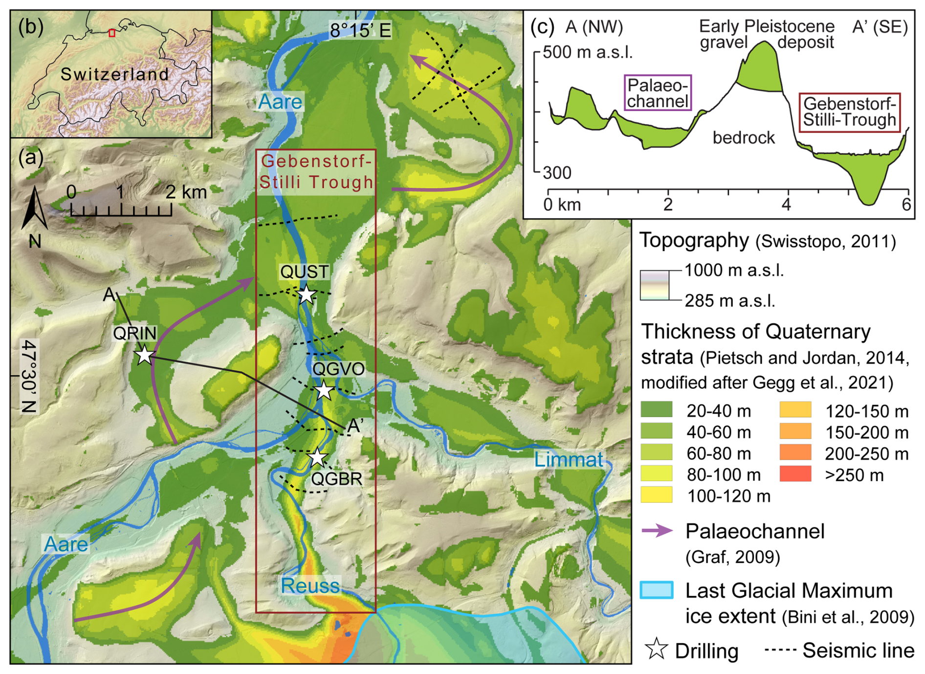
Figure 1The Lower Aare Valley area (a) in central northern Switzerland (b) with drill sites and seismic lines. Panel (c) shows the occurrence of Quaternary sediments (green) along section A–A. Quaternary thickness model supplied by the Swiss National Cooperative for the Disposal of Radioactive Waste (Nagra).

Just beyond the extent of the local Last Glacial Maximum, the area hosts the overdeepened Gebenstorf–Stilli Trough, whose subsurface morphology is constrained in a combined active and passive seismic study analysing surface waves and calibrated with existing and new borehole data (Gegg et al., 2021). This approach reveals a complex trough shape composed of two sub-basins separated by a distinct bedrock ridge. The local bedrock architecture consisting of Mesozoic carbonate rocks and Cenozoic molasse deposits is identified as the primary control of the trough shape, and pressurised subglacial water is identified as the main driver of the incision. This is indicated by the highest erosion efficiency in lithologies susceptible to erosion by running water, while little ice-plucked blocks were encountered in the basal trough infill. Further evidence of subglacial water under pressure is presented in a second case study (drilling QGBR; Gegg et al., 2020), where a palaeokarst network in limestone directly underlying the overdeepening is investigated in detail. Here, the karst walls have been intensively fractured by a post-infilling process. Macro- and microscopic evidence suggests that the most plausible scenario explaining the observed structures is small-scale hydrofracturing due to transient peaks in subglacial water pressure.

After incision, the Gebenstorf–Stilli Trough was quickly infilled with sediments whose lithofacies allow the reconstruction of its further evolution (Gegg et al., 2025a). These sediments are, mostly, glaciolacustrine sand and glaciodeltaic gravel that were later truncated and overlain by a second nested glacial basin (with both basin generations likely infilled during the penultimate glaciation, ca. 185–130 ka; see also Mueller et al., 2024). In the gravels, and in Middle Pleistocene glaciofluvial deposits in a neighbouring palaeochannel, petrographic contributions from all three catchments coalescing in the study area (Aare, Reuss, Limmat; Fig. 1) can be identified, and they indicate changes in palaeoglacier configuration and extent over time. In said palaeochannel, another rich archive of environmental indicators occurs in the shape of a succession of lacustrine fines (drilling QRIN; Gegg et al., 2023). Changes in sedimentary facies and composition represent the transition from a glacier- to a runoff-fed lake, and pollen contents track the emergence of sparse aquatic and open terrestrial (interstadial) vegetation. The lacustrine fines, as well as overlying periglacial colluvium, were also dated to the penultimate glaciation by luminescence (OSL/IRSL; Mueller et al., 2020), and thus especially the penultimate glaciation left ample erosive as well as depositional traces in the Lower Aare Valley. The facies and architecture of the investigated deposits points towards three separate, extensive ice advances (cf. Lowick et al., 2015) and therefore towards a complex glacial period with a significant geomorphic imprint. In summary, this study emphasises the significance of glacial (overdeepened) basins and thorough multi-method investigation of their infill for Quaternary stratigraphy.

Data availability

Besides the references cited above, the data acquired in this study are available in a set of reports published by Nagra (https://nagra.ch/downloads/arbeitsbericht-nab-18-40/, Gegg et al., 2018; https://nagra.ch/downloads/arbeitsbericht-nab-19-02/, Gegg et al., 2019a; https://nagra.ch/downloads/arbeitsbericht-nab-19-03/, Gegg et al., 2019b; https://nagra.ch/downloads/arbeitsbericht-nab-19-01/, Gegg et al., 2019c; https://nagra.ch/en/downloads/arbeitsbericht-nab-21-18-2/, Nagra, 2021).

Competing interests

The author has declared that there are no competing interests.

Disclaimer

Publisher's note: Copernicus Publications remains neutral with regard to jurisdictional claims made in the text, published maps, institutional affiliations, or any other geographical representation in this paper. While Copernicus Publications makes every effort to include appropriate place names, the final responsibility lies with the authors.

Acknowledgements

The author cordially thanks Flavio Anselmetti and Marius Buechi for their guidance through the project, colleagues from Nagra and the University of Freiburg for their continued support, and the anonymous reviewer for constructive recommendations.

Financial support

This research has been supported by the Nationale Genossenschaft für die Lagerung radioaktiver Abfälle (Swiss National Cooperative for the Disposal of Radioactive Waste, Nagra).

The article processing charge was funded by the Quaternary scientific community, as represented by the host institution of EGQSJ, the German Quaternary Association (DEUQUA).

Review statement

This paper was edited by Tony Reimann and reviewed by one anonymous referee.

References

Anselmetti, F. S., Bavec, M., Crouzet, C., Fiebig, M., Gabriel, G., Preusser, F., Ravazzi, C., and DOVE scientific team​​​​​​​: Drilling Overdeepened Alpine Valleys (ICDP-DOVE): quantifying the age, extent, and environmental impact of Alpine glaciations, Sci. Dril., 31, 51–70, https://doi.org/10.5194/sd-31-51-2022, 2022. 

Bini, A., Buoncristiani, J. F., Couterrand, S., Ellwanger, D., Felber, M., Florineth, D., Graf, H. R., Keller, O., Kelly, M., and Schlüchter, C.: Die Schweiz während des letzteiszeitlichen Maximums (LGM) 1 : 500 000, Bundesamt für Landestopographie swisstopo, https://opendata.swiss/de/dataset/die-schweiz-wahrend-des-letzteiszeitlichen-maximums-lgm-1-500000 (last access: 6 November 2024), 2009. 

Gegg, L. and Preusser, F.: Comparison of overdeepened structures in formerly glaciated areas of the northern Alpine foreland and northern central Europe, E&G Quaternary Sci. J., 72, 23–36, https://doi.org/10.5194/egqsj-72-23-2023, 2023. 

Gegg, L., Buechi, M. W., Ebert, A., Deplazes, G., Madritsch, H., and Anselmetti, F. S.: Brecciation of glacially overridden palaeokarst (Lower Aare Valley, northern Switzerland): result of subglacial water-pressure peaks?, Boreas, 49, 813–827, https://doi.org/10.1111/bor.12457, 2020. 

Gegg, L., Deplazes, G., Keller, L., Madritsch, H., Spillmann, T., Anselmetti, F. S., and Buechi, M. W.: 3D morphology of a glacially overdeepened trough controlled by underlying bedrock geology, Geomorphology, 394, 107950, https://doi.org/10.1016/j.geomorph.2021.107950, 2021. 

Gegg, L., Anselmetti, F. S., Deplazes, G., Knipping, M., Madritsch, H., Mueller, D., Preusser, F., Vogel, H., and Buechi, M. W.: Rinikerfeld Palaeolake (Northern Switzerland) – a sedimentary archive of landscape and climate change during the penultimate glacial cycle, J. Quaternary Sci., 38, 174–185, https://doi.org/10.1002/jqs.3471, 2023. 

Gegg, L., Anselmetti, F. S., Deplazes, G., Fuelling, A., Madritsch, H., Mueller, D., Preusser, F., and Buechi, M. W.: Glaciations and landscape change in the Lower Aare Valley (Northern Switzerland) through the Middle Pleistocene, Quaternary Res., 125, 134–153, https://doi.org/10.1017/qua.2024.61, 2025a.​​​​​​​ 

Gegg, L., Salcher, B. C., Pollhammer, T., Cohen, D., Fischer, U. H., and Landgraf, A.: An inventory of subglacial overdeepenings in southern Germany and Austria, Boreas, https://doi.org/10.1111/bor.12693, online first, 2025b. 

Gegg, L., Kuster, A. M., Schmid, D., and Buechi, M. W.: Quaternary Boreholes QBO Riniken-1 & -2 (QRIN1 & QRIN2) Data Report, Nagra Arbeitsbericht NAB 18-40, https://nagra.ch/downloads/arbeitsbericht-nab-18-40/ (last access: 6 November 2024), 2018. 

Gegg, L., Kuster, A. M., Deplazes, G., Madritsch, H., and Buechi, M. W.: Quaternary Borehole QBO Gebenstorf-Brüel (QGBR) Data Report, Nagra Arbeitsbericht NAB 19-02, https://nagra.ch/downloads/arbeitsbericht-nab-19-02/ (last access: 6 November 2024), 2019a. 

Gegg, L., Kuster, A. M., Amschwand, D., Huber, M., Deplazes, G., Madritsch, H., and Buechi, M. W.: Quaternary Borehole QBO Gebenstorf-Vogelsang (QGVO) Data Report, Nagra Arbeitsbericht NAB 19-03, https://nagra.ch/downloads/arbeitsbericht-nab-19-03/ (last access: 6 November 2024), 2019b. 

Gegg, L., Kuster, A. M., Schmid, D., Lemke, K., Deplazes, G., Madritsch, H., and Buechi, M. W.: Quaternary Borehole QBO Untersiggenthal (QUST) Data Report, Nagra Arbeitsbericht NAB 19-01, https://nagra.ch/downloads/arbeitsbericht-nab-19-01/ (last access: 6 November 2024), 2019c. 

Graf, H. R.: Stratigraphie von Mittel-und Spätpleistozän in der Nordschweiz, Beiträge zur Geologischen Karte der Schweiz (N. F.) 168, 198 pp., ISBN 978-3-302-40050-1, 2009. 

Lowick, S. E., Buechi, M. W., Gaar, D., Graf, H. R., and Preusser, F.: Luminescence dating of Middle Pleistocene proglacial deposits from northern Switzerland: methodological aspects and stratigraphical conclusions, Boreas, 44, 459–482, https://doi.org/10.1111/bor.12114, 2015. 

Magrani, F., Valla, P. G., Gribenski, N., and Serra, E.: Glacial overdeepenings in the Swiss Alps and foreland: Spatial distribution and morphometrics, Quaternary Sci. Rev., 243, 106483, https://doi.org/10.1016/j.quascirev.2020.106483, 2020. 

Mueller, D., Preusser, F., Buechi, M. W., Gegg, L., and Deplazes, G.: Luminescence properties and dating of glacial to periglacial sediments from northern Switzerland, Geochronology, 2, 305–323, https://doi.org/10.5194/gchron-2-305-2020, 2020. 

Mueller, D., Gegg, L., Fülling, A., Buechi, M. W., Deplazes, G., and Preusser, F.: Luminescence dating of glacially sourced deposits from northern Switzerland: Comparing multigrain aliquots and single grains of quartz and feldspar, Quat. Geochronol., 82, 101551, https://doi.org/10.1016/j.quageo.2024.101551, 2024. 

Nagra: Morphology of the Overdeepened Gebenstorf-Stilli Trough (Lower Aare Valley) from Seismic Surface Wave Investigations, Nagra Arbeitsbericht NAB 21-18, https://nagra.ch/en/downloads/arbeitsbericht-nab-21-18-2/ (last access: 6 November 2024), 2021. 

Pietsch, J. and Jordan, P.: Digitales Höhenmodell Basis Quartär der Nordschweiz – Version 2014 und ausgewählte Auswertungen, Nagra Arbeitsbericht NAB 14-02, https://nagra.ch/downloads/arbeitsbericht-nab-14-02 (last access: 6 November 2024), 2014. 

Preusser, F., Graf, H. R., Keller, O., Krayss, E., and Schlüchter, C.: Quaternary glaciation history of northern Switzerland, E&G Quaternary Sci. J., 60, 21, https://doi.org/10.3285/eg.60.2-3.06, 2011. 

Swisstopo: swissALTI3D, Swisstopo, https://www.swisstopo.admin.ch/de/hoehenmodell-swissalti3d (last access: 6 November 2024), 2011. 

Download
Short summary
Drillings, outcrops, and seismic data provide insights into a glacial basin and a former river channel in northern Switzerland. Both are infilled with diverse (glacial, lacustrine, fluvial, colluvial) sediments attributed to three separate glaciations. The depth of the glacial basin depends strongly on the underlying rock type, which together with (hydro)fractures provides evidence on the conditions and erosion processes at the ice–rock interface.
Share