the Creative Commons Attribution 4.0 License.
the Creative Commons Attribution 4.0 License.
 | 14 Nov 2025
From the 8.2 ka event to the Little Ice Age: Holocene cold periods and human impact recorded in alpine glaciofluvial peatlands (Silvretta Mountains, Switzerland)
Clemens von Scheffer
François De Vleeschouwer
Gaël Le Roux
Ingmar Unkel
von Scheffer, C., De Vleeschouwer, F., Le Roux, G., and Unkel, I.: From the 8.2 ka event to the Little Ice Age: Holocene cold periods and human impact recorded in alpine glaciofluvial peatlands (Silvretta Mountains, Switzerland), E&G Quaternary Sci. J., 74, 263–279, https://doi.org/10.5194/egqsj-74-263-2025, 2025.
High alpine peatlands are naturally impacted by extreme climatic conditions and heterogeneous topography. In the Alps, humans have been influencing their development for millennia, and accelerating climate change puts them under additional pressure. In the Swiss part of the Fimba Valley (or Val Fenga; > 2350 m a.s.l. (metres above sea level)), small-scale peatlands have been investigated to gain knowledge on climatic and anthropogenic impacts on alpine landscapes using quantitative and semi-quantitative geochemical parameters derived from inter-calibrated portable X-ray fluorescence spectrometry (pXRF) and XRF core scanning, sedimentology, and radiocarbon dating. The onset of peat formation, after the retreat of the Fimba Valley glacier, has been dated to a time window between 10 450 and 9000 cal BP at the lower (northern) end and to 6600 cal BP at the upper (southern) end of a 470 m long transect. Holocene cold episodes appear to have increased erosive glacial activity in the western side of the valley, resulting in high minerogenic sediment loads being deposited on the peatlands by a meltwater channel, interrupting peat accumulation repeatedly. In the early Holocene, distinct minerogenic layers suggest glacier growth and cold and potentially wet conditions around 9200, 8200, and 6300 cal BP. With the impact and extent of the 8.2 ka cold event still being under discussion for this region of the Alps, a coarse gravel layer is strong evidence for a marked glacial response in the Silvretta Mountains to a particularly cold and wet episode. Cooler climate conditions seem to have prevailed around 5400, 5000, 4500, and 3600 cal BP. Afterwards, the proportion of anthropogenic forcing in erosional processes and other disturbances increased. During and since the Middle Ages, soil or sediment erosion and decreasing peat accumulation were and have continued to be consequences of at least one of the following factors: deforestation; livestock grazing and traffic (trade, tourism); and, temporarily, the Little Ice Age. These impacts and their potential effects on carbon accumulation and flood risk mitigation in the valley should be considered in land management practice. Despite their strong minerotrophic character and a likely post-depositional release due to erosion and decomposition in recent layers, the peatlands have preserved clear signals of atmospheric lead (Pb) pollution: one correlated with the Roman period and another around 1450 cal BP. Rapidly changing sedimentation and hydrology in small mountain peatlands are a challenge for radiocarbon chronologies, high-resolution sampling, and the detection of atmospheric geochemical signals. Yet, our study demonstrates that dynamic glaciofluvial stream-bank mires are valuable for the reconstruction of the impact of climate and humans on alpine environments – from prehistory to the present.
Hochalpine Moore unterliegen extremen Klimabedingungen und heterogener Topographie. In den Alpen unterliegt ihre Entwicklung seit Jahrtausenden menschlichem Einfluss und der Klimawandel setzt sie zusätzlich unter Druck. Im Schweizer Teil des oben Fimbatals (auch Val Fenga, 2350 m ü.M.) wurden Kleinstmoore untersucht, um Kenntnisse über den Einfluss von Mensch und Klima auf die alpine Landschaft zu gewinnen. Eingesetzt wurden sedimentologische und geochemische Methoden, darunter interkalibrierte Röntgenfluoreszenzspektroskopie (XRF, tragbar und Kernscanner) und Radiokohlenstoffdatierung. Nach Rückgang des Fimbatalgletschers setzte die Torfbildung zwischen 10 450 und 9000 kal BP im unteren (nördlichen) und um 6600 kal BP im oberen (südlichen) Teil eines 470 m Transekts ein. Holozäne Kaltphasen haben vermutlich die Erosionstätigkeit eines an der westlichen Talflanke gelegenen Gletschers ansteigen lassen. Über einen Schmelzwasserbach führte dies zu höheren Sedimenteinträgen in die tiefer gelegenen Moore und zu temporären Unterbrechungen der Torfbildung. Im Frühholozän deuten solche Sedimentlagen auf kalte und/oder nassere Bedingungen um 9200, 8200 und 6300 kal BP hin. Obwohl die Misox-Schwankung (8.2 ka Ereignis) in diesem Teil der Alpen noch diskutiert wird, deutet alles darauf hin, dass es in der Silvrettaregion zu dieser Zeit besonders kalt und nass war. Weitere kühlere und/oder feuchtere Bedingungen herrschten vorübergehend um 5400, 5000, 4500 und 3600 kal BP. Nachfolgend gewinnt menschlicher Einfluss auf Erosionsprozesse und weitere Störungen der Landschaft an Bedeutung. Seit dem Mittelalter waren und sind erhöhte Boden- und Sedimenterosion sowie sich verlangsamende Torfakkumulationsraten die Konsequenz unterschiedlicher Faktoren: Entwaldung, Beweidung, Handel, Tourismus, und temporär die Kleine Eiszeit. Diese Einflüsse und ihre Effekte auf die Akkumulation von Kohlenstoff sowie auf das Hochwasserrisiko im Paznauntal sollten in die zukünftige Landschaftsplanung einbezogen werden. Trotz ihres minerotrophen Charakters und möglicher nachträglicher Erosion und Zersetzung in jüngeren Ablagerungen, haben die untersuchten Moore atmosphärische Einträge von Blei gespeichert: In der Römerzeit und erneut um 1450 kal BP. Rapide wechselnde Sedimentation und Hydrologie in Kleinstmooren im Gebirge sind eine Herausforderung für Altersdatierungen, hochaufgelöste Beprobung und die Detektion atmosphärischer geochemischer Signale. Trotzdem verdeutlicht unsere Studie, dass dynamische glaziofluviale Ufermoore wertvolle Kenntnisse zu den Auswirkungen klimatischer und anthropogener Einflüsse auf die alpine Landschaft liefern können – von der Vorgeschichte bis in die Neuzeit.
- Article
(7288 KB) - Full-text XML
-
Supplement
(1018 KB) - BibTeX
- EndNote


Ombrotrophic peatlands are highly sensitive archives of climate and human impacts. However, extreme climate conditions and rough morphology in dynamic high alpine environments often sustain only minerotrophic mires (fens) with slow peat accumulation and a potentially strong influence of extreme erosion or sedimentation events caused by highly variable water input.
The upper Fimba Valley (also referred to as the Fimber Valley or Val Fenga) in the Swiss part of the Silvretta mountain range is such an extreme environment. Several local studies were carried out on palaeoecology (Bauerochse and Katenhusen, 1997; Dietre et al., 2014; Kappelmeyer et al., 2024; Nicolussi, 2012; Pott et al., 1995), soils (Kothieringer et al., 2015), glaciers (Hertl, 2001), and human–climate interrelation (Walser and Lambers, 2012). Humans have been occupying the area repeatedly over the last 11 000 years (Reitmaier, 2012), and local toponyms refer to pre-Roman pastoralism (Kathrein, 2012). Reitmaier (2017) summarises the evolution of regional livestock management, and Carrer et al. (2016) revealed some of the first evidence for dairy production occurring as early as the Early Iron Age, around 2800 cal BP (see Röpke et al. (2011) for the classification of cultural periods). Moraines in the Austrian Silvretta region stabilised around 10 000 cal BP (Moran et al., 2015; Braumann et al., 2020), but most Holocene glacier deposits were overprinted during the Little Ice Age (LIA) (Moran et al., 2017). Small-scale minerotrophic mires are the only palaeoenvironmental archives available in the Fimba Valley which can provide continuous records. While earlier studies focused on pollen or megafossils and macrofossils, semi-quantitative geochemical proxies have been considered in the neighbouring Urschai Valley (Dietre et al., 2020).
Applying geochemical analyses with X-ray fluorescence spectrometry (XRF) to peat samples to obtain quantitative results is still very rare. Over the last decade, portable XRF (pXRF) began to be used for peat analysis (Ravansari and Lemke, 2018; Shand and Wendler, 2014; Shuttleworth et al., 2014; von Scheffer et al., 2019, 2024). In addition, semi-quantitative XRF core scanning, yielding intensities instead of concentrations, has been deployed and evaluated with regard to its applicability to fresh peat (Kern et al., 2019; Longman et al., 2019; Poto et al., 2015). This study uses both techniques but relies mainly on pXRF, inter-calibrated with 26 samples digested with hydrofluoric acid (HF) and measured with inductively coupled plasma mass spectrometry (ICP-MS), as an effective method to quantify a range of geochemical elements in alpine peatlands (e.g. von Scheffer et al., 2024). Characteristics of small-scale mountain peatlands in the proximity of former glaciers and within the range of the potential treeline are complex processes of hydrology, peat accumulation, and/or erosion processes, with challenging chronologies as a consequence. Therefore, one goal of this study is to test if these peatlands can still act as suitable geo-archives with geochemical proxies recording past land use or climate changes. Turning this complexity into an opportunity, we presume that it should result in a high sensitivity to change, leaving traceable imprints in the sediment record. By using local palynological studies and the often fragmented archaeological evidence as context, we ultimately aim to improve the understanding of the timing and extent of climate fluctuations and human activity and their respective impacts on peatlands in extreme alpine conditions like in the Silvretta mountain range.
The wide U-shaped Fimba Valley, between the upper Inn Valley in the south and the Paznaun Valley in the north (Fig. 1), belongs to the Silvretta Mountains. It rises from 1400 m a.s.l. (metres above sea level) at Ischgl (Austria) to 2264 m a.s.l. at the Heidelberg alpine lodge (Heidelberger Hütte) and is surrounded by peaks above 3000 m a.s.l. (e.g. Piz Tasna, Fluchthorn). Some areas show the recent disappearance of glaciers. The small creeks of Aua Naira (upper valley) and Aua da Fenga (lower valley) are tributaries to the river Trisanna (Fig. 1). Mixed Quaternary moraines and boulders to scree cover heterogenous metamorphic bedrock (Springhorn, 2007; Swisstopo, 2018).
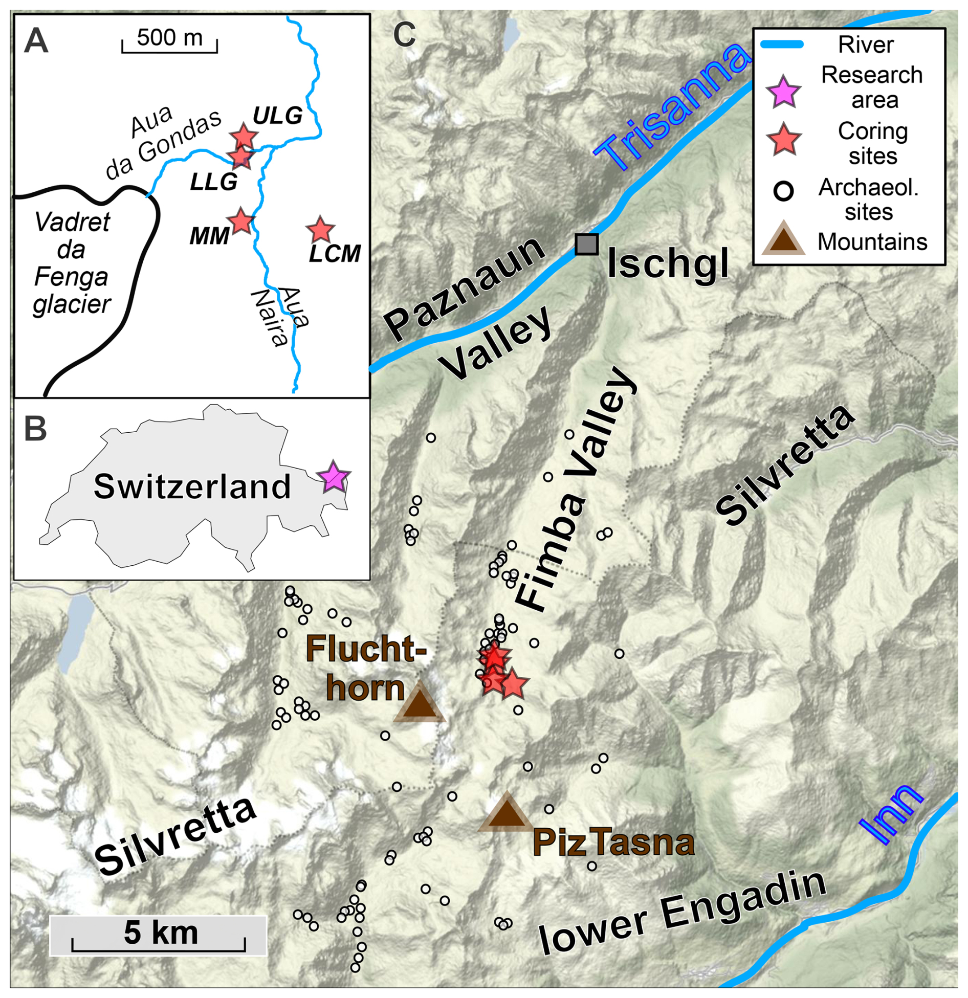
Figure 1Cored mire sites – Lower Coffin Mire (LCM), Lower Las Gondas (LLG), Marmot Mire (MM), Upper Las Gondas (ULG) – as red stars (A, C) and the geographical location of the Fimba Valley and the research area (B) in the Silvretta Mountains. The compilation of archaeological sites (white circles in panel C) in the area is from Dietre et al. (2014). Map C is based upon a map by Stamen Design under CC-BY-3.0 and by OSM contributors under ODbl.
Annual precipitation of approx. 1110 mm and annual mean temperatures of 1.1 °C at 2040 m a.s.l. (Obervermunt, 1971–2000; ZAMG, 2022) classify the climate as alpine. The growing season at the study sites is > 80 d (Bauerochse and Katenhusen, 1997). Currently, the tree line is several hundred metres below the potential natural position at ca. 2400 m a.s.l. (Remy, 2012). Many features of the landscape up to 2600 m a.s.l. are shaped by cattle. Touristic activities are present year-round.
The Lower Las Gondas mire (LLG, 2355 m a.s.l., Fig. 1) is located on a side moraine on the western valley side, just below the Upper Las Gondas mire (ULG), which had been the subject of earlier studies (Bauerochse and Katenhusen, 1997; Dietre et al., 2014; Pott et al., 1995).
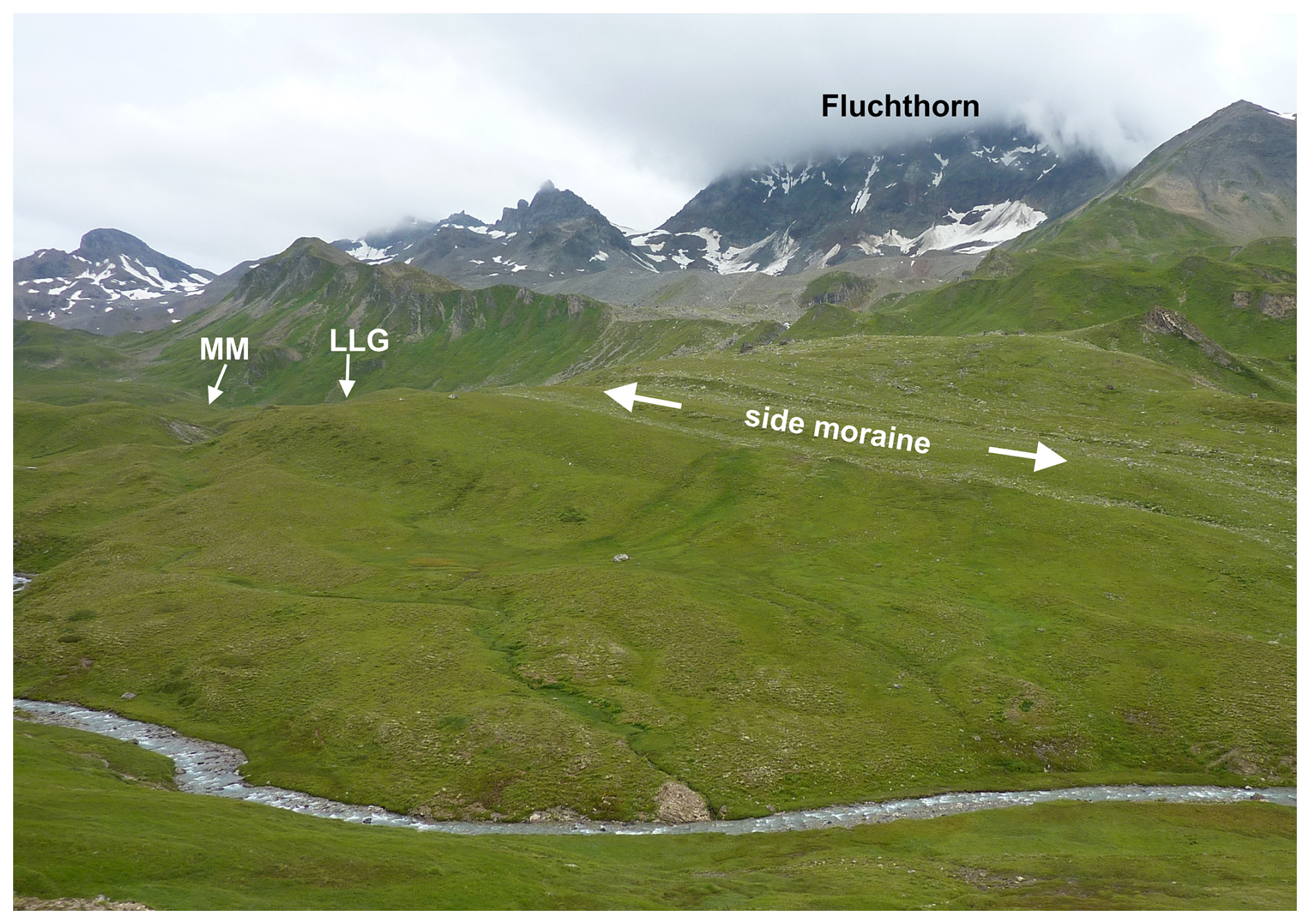
Figure 2SW view from eastern valley side across Aval Val Fenga. Main study site (LLG), side moraine (centre), cloudy Fluchthorn summit, and former glacial field (upper centre).
Contrarily to the slope of the valley, Lower Las Gondas is on the southward-dipping, upper end of the side moraine (Fig. 2).
Originating from the former glacier field Vadret da Fenga at the eastern flank of the Fluchthorn (also known as Piz Fenga; Jacot-Guillarmod and Leuzinger, 1894), the Aua da Gondas flows past ULG and LLG into the Aua Naira (Fig. 2). Moraines around the mires are of Late Pleistocene to Holocene age (Hertl, 2001). The site called Marmot Mire (MM), 350 m south of LLG, is traversed by a small stream. On the side of the eastern valley, the site called Lower Coffin Mire (LCM; 2410 m a.s.l.) is fed and drained by a runnel. The mires are largely dominated by Cyperaceae, showing degradation by flowing water, cryoturbation, and grazing (Remy, 2012).
3.1 Fieldwork
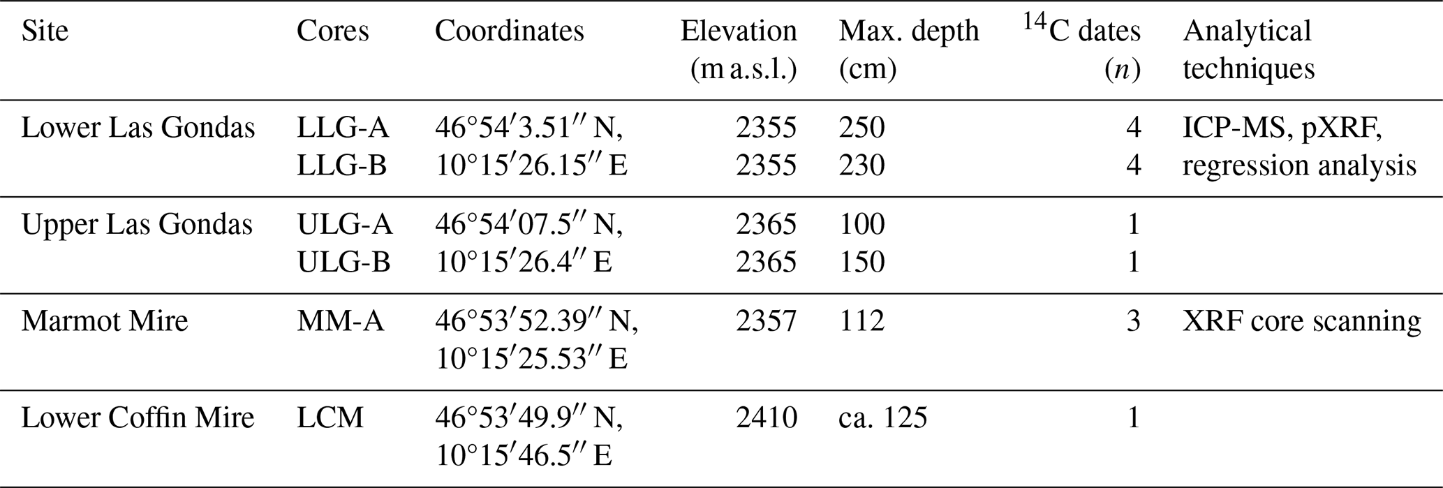
Sediment coring took place in 2016, using a 50 or 100 cm long and 5 cm wide Russian corer (Jowsey, 1966). In Lower Las Gondas, core LLG-A reached a depth of 250 cm. The parallel LLG-B core (ca. 1.5 m off LLG-A) covers 230 cm depth. In the Upper Las Gondas mire, a composite profile of ca. 150 cm was taken, consisting of the cores ULG-A and the parallel ULG-B.
The Marmot Mire profile MM-A reached approx. 112 cm depth because the second 50 cm section starts at approx. 62 cm. The Lower Las Gondas coring site is located about 130 m south of the ULG and 340 m north of the MM core. Another profile was taken in the Lower Coffin Mire (LCM). Descriptions of the cores (Table S1) and photos (Figs. S1 and S2) can be found in the Supplement.
3.2 Sampling and geochemistry
The upper metre of LLG-A was frozen prior to slicing (ca. 1.1 cm resolution) and subsampled for geochemistry, radiocarbon dating, and dry bulk density. Deeper sections were visually described and dated only as they consist of mainly minerogenic sediment. From dry homogenised samples, 76 were selected for pXRF analysis (Niton Xl3t, soil mode), and 26 were selected for ICP-MS measurements after complete acid digestion with HF. Sample preparation, processing, and measurements were carried out with the same instruments and as described in von Scheffer et al. (2019). Certified Reference Materials (CRMs; NIST-1515, GBW-07603, NJV-942, NJV-941) were processed and measured along with the ICP-MS samples. Additionally, IAEA-336, BCR-060, NIST-1575a, and IPE-176 were analysed by pXRF. The MM profile was measured with an Avaatech XRF core scanner (settings: 10 kV, 750 µA, 10 s; 30 kV, 2000 µA, 20 s, Pd-thick filter) at Kiel University, Germany.
Due to the limited range of elements that pXRF reliably measures in peat (see von Scheffer et al., 2024), we only consider titanium (Ti), lead (Pb), potassium (K), iron (Fe), strontium (Sr), and rubidium (Rb). With regard to the interpretation, Ti can be used to detect mineral matter eroded in the catchment, either naturally or anthropogenically, and deposited on the peatland (e.g. Hölzer and Hölzer, 1998), and Pb can be used to indicate anthropogenic activities, for example, from mining and (airborne) pollution (e.g. Shotyk et al., 2001). Pb has high adsorption, even in fen peat (Krumins and Robalds, 2015) and under water table fluctuations (Rothwell et al., 2010). Furthermore, Pb and Ti can be measured reliably by both pXRF (Shuttleworth et al., 2014; von Scheffer et al., 2019, 2024) and Avaatech XRF core scanners (Kern et al., 2019).
3.3 Radiocarbon dating
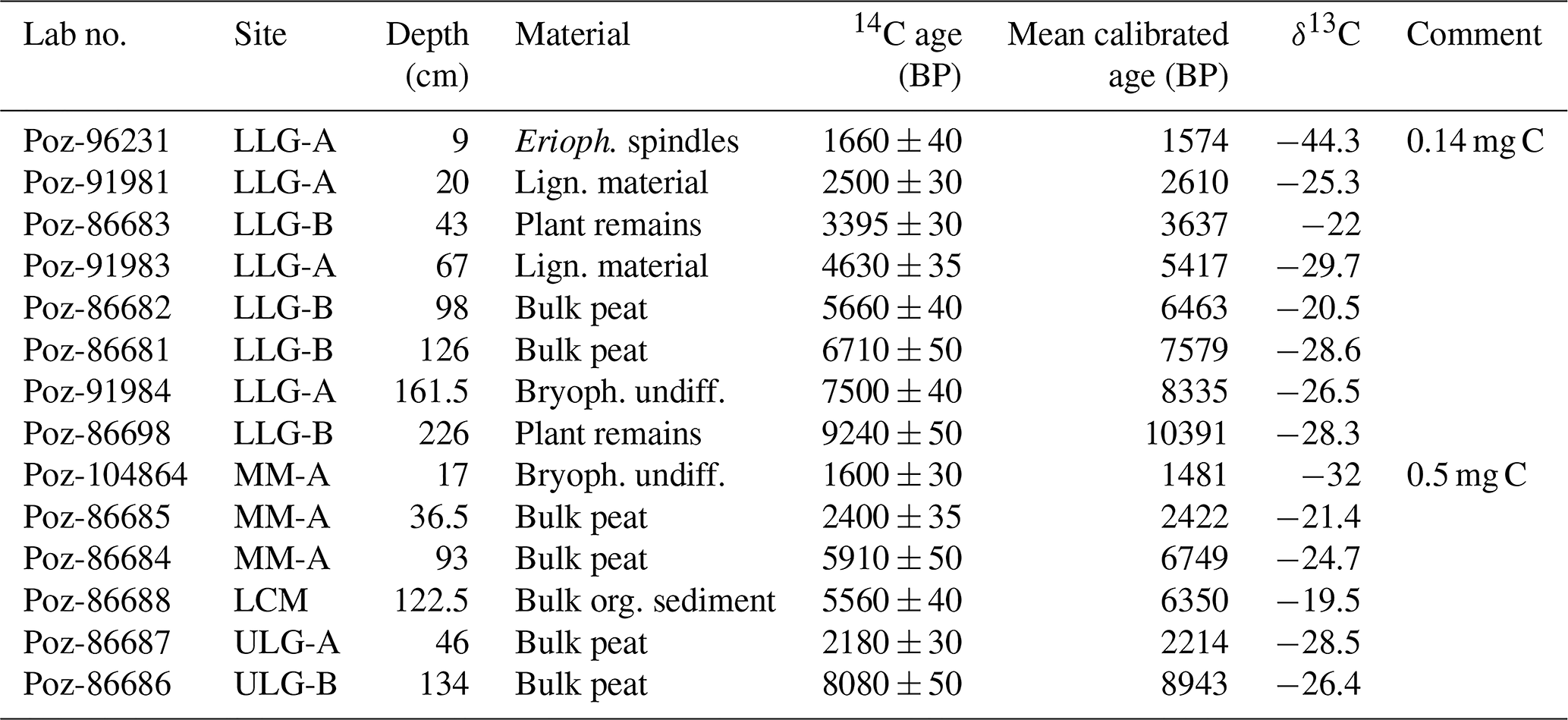
Four radiocarbon samples were taken from LLG-A and four more were taken from LLG-B at minerogenic marker horizons present in both LLG-A and LLG-B (Table 1), proving the similarity and comparability of both cores. Further radiocarbon samples were taken from MM-A, ULG-A and ULG-B, and LCM. All were sent to the AMS Laboratory at the Adam Mickiewicz University Poznań, Poland, for dating. Age–depth models (ADMs) were produced in R version 4.1.1. (R Core Team, 2021) with rbacon v.2.5.7 (Blaauw and Christen, 2011) using the IntCal20 calibration curve (Reimer et al., 2020).
Table 1Overview of sites studied in the Silvretta Mountains (Switzerland) with sediment cores taken, number of radiocarbon dates performed, and methods used (inductively coupled plasma mass spectrometry (ICP-MS), portable X-ray fluorescence (pXRF) or XRF core scanning).
4.1 Chronology
The radiocarbon dating results in Table 2 were used to build the age–depth models for LLG and MM in Fig. 3. The oldest date in the silty section of LLG is calibrated to be ca. 10 400 cal BP, and peat and/or sediment accumulation declines from values of around 0.3 mm a−1 to 0.1 mm a−1 in the upper metre. The peat accumulation rate in MM is similar to that in LLG and ranges between 0.1 and 0.2 mm a−1.
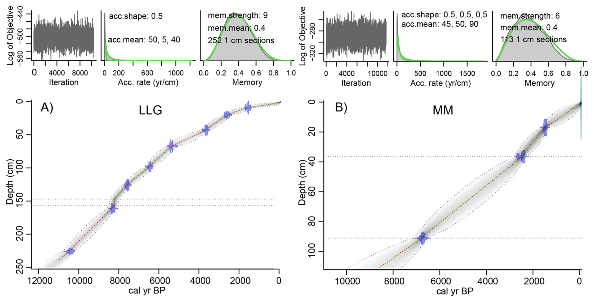
Figure 3Age–depth models for the sites LLG-A and LLG-B (A) and MM (B) in the Silvretta Mountains (Switzerland). Median age is shown, with the grey-shaded area representing the 95 % confidence interval. Section between grey dotted lines in panel (A) = event layer.
Table 2Radiocarbon dating performed for the sites studied in the Silvretta Mountains (Switzerland). Depths in LLG-B are adjusted according to marker horizons in LLG-A. Mean calibrated ages were calculated from probability ranges of > 68 %.
MM's deepest section is extrapolated and, hence, has a high uncertainty, adding to the uncertainty resulting from there being only three radiocarbon dates in the profile. Peat accumulation in ULG and LCM started before 9100 cal BP and after 6350 cal BP, respectively. A basic ADM of ULG can be found in Fig. S2 in the Supplement.
4.2 Quality control and regression analyses (in LLG)
The underlying results of ICP-MS, pXRF (internal soil mode and/or calibration), and XRF measurements, as well as certified values, are available on Zenodo (von Scheffer et al., 2025). ICP-MS measurements of CRMs are largely within 10 % of certified concentrations. Figures 4 and 5 illustrate the large concentration range. To account for the strong matrix changes, non-peat samples were omitted in regression analyses of Pb, Fe, and Ti.
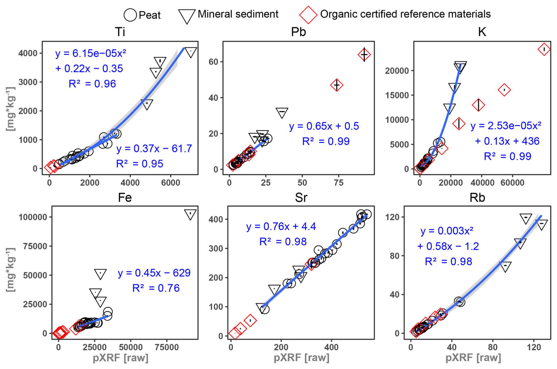
Figure 4Regression analyses for element measurements with pXRF (soil mode) vs. ICP-MS in different sample types.
Two regressions are possible for Ti: a non-linear trend sets in and marks the matrix transition between minerogenic and organic (peat) sediment, starting around 1000 mg kg−1. The regression function is polynomial or linear for peat samples only. Either way, R2 is > 0.95. For Pb, a linear regression for peat yields R2 = 0.99, but the transfer function underestimates concentrations in minerogenic sediment. The regression for Rb can be described with a second-degree polynomial function (R2 = 0.98). High concentrations of Sr show an excellent linear fit (R2 = 0.98), almost matching true concentrations. In contrast, the fit for Fe is relatively low (R2 = 0.76), even with minerogenic samples omitted. K is described with a second-order polynomial function (R2 = 0.99), although a linear fit would work well, if only peat and organic CRMs were considered.
In general, linear regressions appear to be a good choice when working with only highly organic or peat samples. A matrix effect, depending on the mineral or organic content, is obvious for Ti, Fe, and K. The regression analysis indicates an underestimation of Pb in non-peat samples by up to 25 % and shows a similar effect for Ti. This effect is levelled out when considering Pb enrichment factors (EFs). The CRMs' alignments with the fit of the linear regressions support the viability of using pXRF on peat samples, and the regression analysis demonstrates that experimental transfer functions can transform pXRF measurements of Pb, Ti, Rb, Sr, and K into quantitative or near-quantitative values by means of inter-calibration (see von Scheffer et al., 2019, 2024), even, to some extent, in heterogeneous peat profiles. A methodological study could help in defining the transition from an organic to a mineral-dominated matrix (linear vs. non-linear transfer functions) and in choosing the proper mode of operation of the pXRF device.
4.3 Elemental profiles
Figure 5 shows the elemental profiles measured and inter-calibrated in LLG-A and MM with depth.
-
Sr (LLG). Strontium is at a maximum of 400 mg kg−1 between 83 and 65 cm and minima of 10–120 mg kg−1 in the top 6 cm and at 95 cm.
-
K, Rb, Ti (LLG). A distinct maximum shows from 97 to 93 cm, followed by a decrease. Sharp increases at 62, 56, 44–40, 38, and 33 cm and between 6 cm and the surface correspond to visible minerogenic layers. Less distinct peaks occur at 82–63 and 32–6 cm. Furthermore, Ti and Zr have elevated contents at 68.5, 21, and 16.5 cm.
-
Fe (LLG). Fe is concentrated in minerogenic layers but strongly underestimated in the inter-calibrated pXRF results in these layers when compared to the ICP-MS results (see solid vs. dotted line in Fig. 5).
-
Pb (LLG). While Pb is below the limit of detection (LOD) in peat layers around 76 cm (minimum calibrated to 1–2 mg kg−1), higher concentrations are mostly concomitant with minerogenic content, e.g. at 56 and 42 cm (12–20 mg kg−1). Solely at 13 cm, a peak of 25 mg kg−1 is independent of minerogenic content.
-
Pb, Ti (MM). Ti reflects the succession from minerogenic to organic in the lower section. Minor elevations appear at 51 cm and in the near-surface. The Pb counts are relatively stable and increase in the upper 10 cm. Due to the sharp transition to organic content and the associated matrix effect, the deepest section is not considered in the discussion.
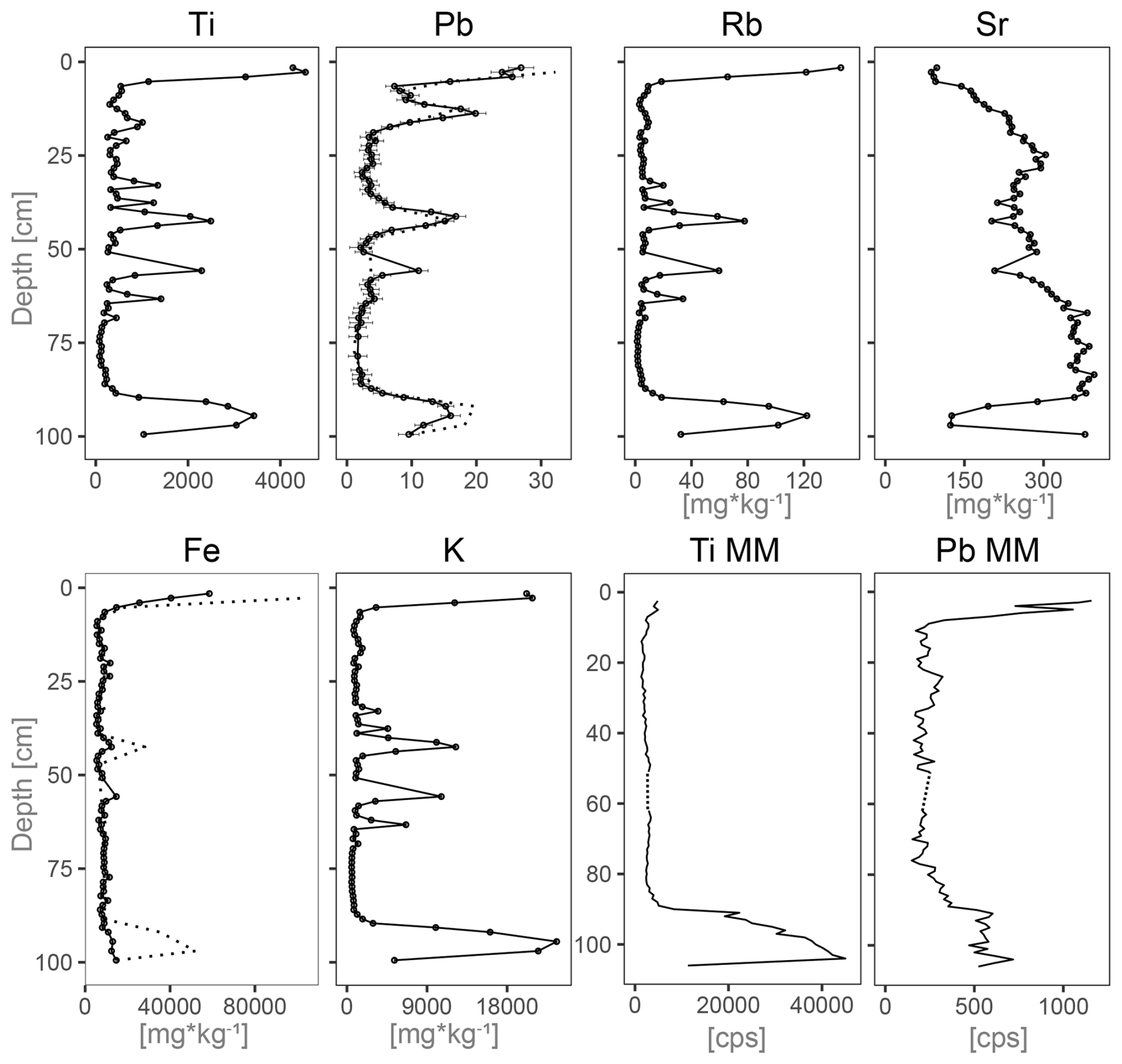
Figure 5Elemental profiles in LLG-A (inter-calibrated pXRF) and in MM (XRF core scan). Dotted lines for Pb and Fe (LLG) are ICP-MS measurements. Pb and Ti in MM in counts per second. Dotted lines in MM mark missing data.
To interpret the quantitative geochemical data in our Lower Las Gondas peat profile and to compare it with the semi-quantitative data of the Marmot Mire profile (Fig. 6), we calculate mineral accumulation rates (MARs, in mg m−2 a−1), i.e. surface input of mineral matter, enrichment factors (EFs), and the potential fraction of anthropogenic Pb accumulation (Pb ARanth.). The functions for these calculations are based on Shotyk et al. (2001, 2002), with Ti being the conservative reference element, and are applied as in von Scheffer et al. (2024). The elemental ratio of Pb Ti of 0.0049 in non-peat layers in LLG (at 97 cm) should represent the local geological background. Its value is near the upper continental crust (0.0042, McLennan, 2001) and is, therefore, used in our calculations. Although atmospheric element deposition plays a rather small role in the peatlands investigated here, the principle of the calculations is similar. Due to the semi-quantitative XRF core-scanning data in the MM profile, Ti and the ratio of Pb to Ti are used in place of MAR and Pb EFs.
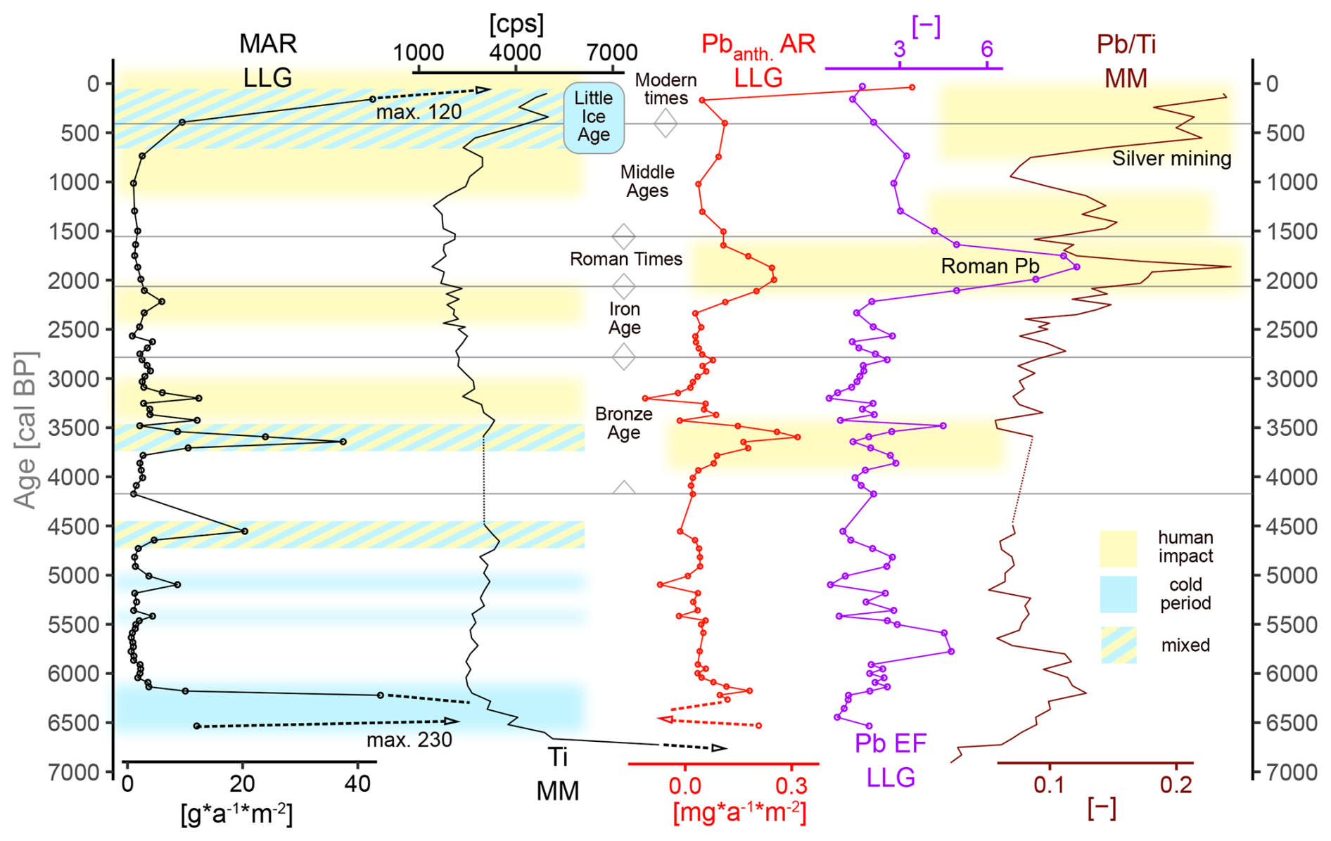
Figure 6Mineral accumulation rates (MARs; black with markers), Pb ARanth. (red) and Pb EFs (violet) in Lower Las Gondas (LLG; inter-calibrated pXRF) and Ti (black) and Pb Ti (brown) in Marmot Mire (MM; XRF core scanner) in the Silvretta Mountains (Switzerland). Dashed lines with arrows mark the cut graph. Dotted lines mark missing data in the MM peat record. Periods interpreted as cool are in light blue, and periods interpreted as human impact are in yellow. Combinations of both are in blue and yellow parallel hatching. Boundaries of cultural periods are based on Röpke et al. (2011).
Erosional input and changes in peat accumulation in paraglacial landscapes like the Fimba Valley can be a result from anthropogenic (land use) and climate impacts (temperature, precipitation). Cooler temperatures generally cause shorter growing periods and sparser vegetation cover, making soil and sediment prone to erosion by precipitation, meltwater, and freeze–thaw cycles. Consequently, mires and, especially, glaciofluvial stream-bank mires in mountainous areas like Lower Las Gondas should receive higher sediment loads during increased glacial activity upstream (e.g. Matthews et al., 2005; Shakesby et al., 2007). In our case, upstream is the Vadret da Fenga (Fig. 1) and not the former main Fimba Valley glacier (Hertl, 2001).
5.1 Early and mid-Holocene (10 700 to 4200 cal BP)
Peat development did not start simultaneously across the Fimba Valley. Dietre et al. (2014) date the onset of peat accumulation in the upper part of the Las Gondas mire (ULG) to 10 450 cal BP, which is in line with general warming after 10 500 cal BP in the Alps (Ivy-Ochs et al., 2009). At an approximately similar age, our record from the lower part of Las Gondas (LLG) shows only silt sedimentation. Bauerochse and Katenhusen (1997) date the onset of peat formation in Upper Las Gondas to 7620–8050 cal BP. In our Upper Las Gondas record, peat accumulation was continuous, at least since 9150–8750 cal BP (Table 2), whereas noteworthy and undisturbed peat layers do not appear before 7500 cal BP in Lower Las Gondas. In Marmot Mire (MM), the onset of peat accumulation is modelled to be around approx. 6600 cal BP, although the uncertainty of the age–depth model is relatively high, especially in the deepest section (Fig. 3).
Given that the three sites of ULG, LLG, and MM are located along a 470 m north–south transect, following the main valley axis (Fig. 1), a slow glacial retreat during the early Holocene may be reconstructed, allowing the first peat formation after 10 450 cal BP at the northernmost ULG and reaching the sites of MM and LCM up to 500 m further south after 6600 cal BP, about 4000 years later. Although, LLG is only slightly further south than ULG, peat accumulation in LLG was often interrupted and less continuous because of its proximity to the glacier-fed stream Aua Naira, with recurring sediment inwash. Of course, glacier retreat and the different ages of the onset of peat accumulation are not proportional because factors like insolation, hydrology, morphology, and microclimate are important. A more precise reconstruction of the retreat of the Fimba Valley glacier would require a dedicated study, including more peatlands with detailed chronologies from a longer transect along the valley axis.
A thin gravel layer in LLG at 9200 cal BP may correspond to a Northern Hemisphere cold event (Fleitmann et al., 2008) and cooler temperatures in the western Alps (Tinner and Kaltenrieder, 2005). Therefore, glacial activity could have caused this alluvial horizon, either as a result of culmination or a beginning retreat (e.g. Joerin et al., 2008). A subsequently warmer climate, with regional glacier regression until at least around 8400 cal BP (Nicolussi and Patzelt, 2000), is reflected by charcoal particles and an increase in wood pieces and generally higher organic content with a thin peat strata in our LLG sequence between 9000 and 8200 cal BP. Our observations are also in line with Tinner and Ammann (2001), describing a warm and stable phase in this period, with trees present in situ in ULG (Nicolussi, 2012).
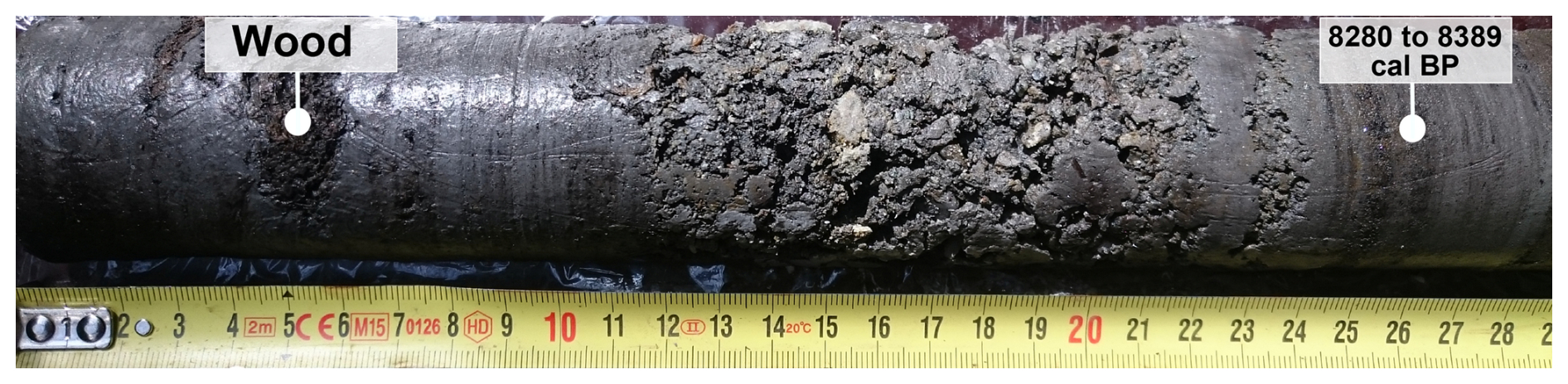
Figure 7Coarse sediment layer in Lower Las Gondas (LLG). Underlying moss dated to 8280 to 8390 cal BP. Wood indicates warming afterwards.
A massive layer of coarse gravel in Lower Las Gondas LLG (Fig. 7), radiocarbon dated by underlying moss (Poz-91984, Table 1), points to strong erosive activity upstream around 8200 cal BP. Though very basic, the age–depth model of ULG (Fig. S3 in the Supplement) puts the only silt layer visible in our Upper Las Gondas record at 137 cm depth in the range of 8200 cal BP as well. The basal age reported by Bauerochse and Katenhusen (1997) for Upper Las Gondas could also be associated with this 8.2 ka minerogenic event layer. Furthermore, the MM sequence has coarse gravel in the deepest part, which is also modelled to be around the age of approx. 8200 cal BP (Fig. 3B). These observations agree with the absence of trees near ULG after 8400 cal BP (Nicolussi, 2012) and with a descending treeline and Corylus decline around 8300 cal BP (Dietre et al., 2014, 2012).
The 8.2 ka cold event is prominent in many Northern Hemisphere records (e.g. Alley et al., 1997; Alley and Ágústsdóttir, 2005; Rohling and Pälike, 2005; Thomas et al., 2007). In the Alps, evidence was largely found in its western parts (Haas et al., 1998; Heiri et al., 2003; Ilyashuk et al., 2011; Nicolussi and Schlüchter, 2012; Wick and Tinner, 1997). Its occurrence in the Silvretta Mountains (Kerschner et al., 2006) was confuted by Moran et al. (2015), and no response of the nearby Ochsental glacier was documented (Braumann et al., 2020). Nicolussi and Patzelt (2000) document glacier progression after 8400 cal BP in the Kauner Valley, not far east of the Silvretta. In speleothems, Wurth et al. (2004) see a response northwest of the Fimba Valley, whereas Vollweiler et al. (2006) did not find clear evidence southeast of it. A pollen record from the northeastern Alps (Schubert et al., 2023) shows only a subtle signal. While Magny et al. (2003) suggest cold and wet conditions in the latitudes of the Alps, Spötl et al. (2010) suggest a cold and dry spell, summarising studies from the northern, southern, and central Alps not showing significant glacier progression. The sedimentation patterns in LLG, ULG, and possibly MM imply a marked glacial response to the 8.2 ka event in the Fimba Valley. We argue that only a cold and wet climate could have generated glacial activity strong enough to move the gravel layer into our LLG record. An ancient debris flow, with boulders visible in the field (or in publicly available satellite imagery) points to the gravel's origin: the glacier Vadret da Fenga at the northwestern flank of the Fluchthorn (Figs. 1A and 2).
The high silt content speaks to still relatively cold and wet conditions until 7500 cal BP, which is well in line with the general climate in the Alps during this period, which is also referred to as the “Misox oscillation” (e.g. Valsecchi and Tinner, 2010). Yet, the occurrence of woody material indicates brief warm episodes with a re-ascending tree line, for example, at approx. 7850 cal BP (Fig. 7, age of the layer from the age–depth model). Noteworthy peat accumulation beginning after 7500 cal BP in LLG is briefly interrupted by a silt layer at 7300 cal BP, concurrent with a pausing glacier recession in southeastern Switzerland (Joerin et al., 2008).
Sporadic human presence is evident before 8200 cal BP (Cornelissen and Reitmaier, 2016) and until approx. 6400 cal BP (Reitmaier, 2012; Dietre et al., 2014; Kothieringer et al., 2015;). However, a prominent silt horizon in LLG, centred around 6300 cal BP, is very likely to be the result of climate forcing. This is supported locally by pollen evidence (Dietre et al., 2014) and in the eastern Silvretta (Wahlmüller, 2002). Furthermore, the record of Kappelmeyer et al. (2024), which is only ca. 500 m north of the Las Gondas mire, shows a temporary but significant decline in tree pollen and macro-charcoal at the time. The almost simultaneous onset of peat accumulation in mires in the Kleinwalser Valley (von Scheffer et al., 2019) was tied to a colder and wetter climate in the northern and central Alps at the time (e.g. Bortenschlager, 2010; Haas et al., 1998; Ivy-Ochs et al., 2009; Joerin et al., 2006, 2008; Nicolussi and Patzelt, 2000; Wurth et al., 2004). The following, more consistent peat accumulation in MM and LCM suggests a change to warmer and stable conditions, also reflected in the low glacier fluctuation (Joerin et al., 2006).
Previous studies in Las Gondas (Bauerochse and Katenhusen, 1997; Dietre et al., 2014) do not mention minerogenic layers embedded in the peat, neither at 8200 nor at 6300 cal BP. This illustrates the heterogeneity of high alpine mire environments in the direct vicinity of glaciers and streams. It shows that the direct glacier link of our Lower Las Gondas record makes it sensitive to glacial activity, similarly to observations and processes described in a glaciofluvial stream-bank mire by Shakesby et al. (2007).
The small MAR increase at 5400 cal BP (Fig. 6) is contemporaneous with a tree pollen decline in Las Gondas, reported by Dietre et al. (2014), and with cold conditions (Bortenschlager, 1970). High water levels in Lake Constance also point to higher precipitation (Magny et al., 2006). Another MAR peak around 5000 cal BP in our record (Fig. 6) seems to reflect a general Alpine cold period (Haas et al., 1998; Ivy-Ochs et al., 2009). In contrast, a subsequent peak is recorded in MAR around 4500 cal BP (Fig. 6). Although this is based on a single measurement, the layer was visible in both LLG-A and LLG-B. It may be climate driven as glacier advances in the central Alps are reported for this period (Joerin et al., 2006; Nicolussi and Patzelt, 2000), or it may be related to soil disturbances caused by increasing human activity, mainly pastoralism, emerging in the region after 4800 cal BP (Bauerochse and Katenhusen, 1997; Dietre et al., 2014, 2017; Kappelmeyer et al., 2024; Kothieringer et al., 2015).
5.2 Late Holocene (4200 cal BP to present)
The first of three Bronze Age MAR peaks in Lower Las Gondas at 3600 cal BP (Fig. 6) likely reflects colder conditions (Haas et al., 1998; Nicolussi and Patzelt, 2000), with less dense vegetation cover favouring erosion. Despite local archaeological evidence between 4000 to 3600 cal BP (Reitmaier et al., 2018), human impacts had been decreasing temporarily (Dietre et al., 2017), suggesting that climate played a big role in this MAR peak. The two following smaller MAR increases around 3300 cal BP (Fig. 6) concur with warming climate (Hormes et al., 2001), possibly fostering livestock management at this elevation (Bauerochse and Katenhusen, 1997; Dietre et al., 2014). Evidence of intensifying human occupation and more sophisticated forms of agro-pastoralism during this period was found in the Silvretta Mountains and the adjacent Prättigau and Oetz Valley (Dietre et al., 2017; Festi et al., 2014; Reitmaier, 2012; Reitmaier et al., 2018; Röpke et al., 2011; Röpke and Krause, 2013; Wahlmüller, 2002).
Higher mineral content is recorded in the XRF results of the Marmot Mire record (MM) around 3500 cal BP. Unlike Las Gondas, MM is not connected to the Vadret da Fenga glacier field northeast of Fluchthorn by a meltwater channel, and human impact should be easier to track in mires like MM or ULG (which is further from the channel than LLG), where dispersed signals (pollen, soil erosion, dust) are less obscured by direct surface sediment or minerogenic input. Consequently, these less intense fluctuations in minerogenic content in MM and LLG during the middle to late Bronze Age (Fig. 6, 3400 to 3200 cal BP) suggest anthropogenic activity, which is supported by evidence for local and regional agro-pastoral land use causing soil disturbance (Carrer et al., 2016; Dietre et al., 2014; Reitmaier et al., 2018). Furthermore, pollen data from Dietre et al. (2014) and Bauerochse and Katenhusen (1997) suggest drier conditions between 6000 and 3000 cal BP, reducing the likelihood of climate-induced minerogenic inputs into LLG due to low glacier activity, less meltwater, and less intense slope runoff.
Following large-scale anthropogenic landscape change in the central Alps (e.g. Festi et al., 2014; von Scheffer et al., 2019), a slow cooling trend, reconstructed from glaciers and tree lines, set in after 3300 cal BP (Haas et al., 1998; Ivy-Ochs et al., 2009; Nicolussi and Patzelt, 2000). However, treeline reconstructions are less conclusive due to human-driven clearings (Nicolussi et al., 2005; Wick and Tinner, 1997), assuming that the Fimba Valley treeline has been anthropogenically altered since the Bronze Age (Nicolussi, 2012).
Despite a cooling trend that was ongoing around 2800 cal BP (Haas et al., 1998; Ivy-Ochs et al., 2009; Joerin et al., 2006; Nicolussi, 2012; Nicolussi et al., 2009), distinct silt layers are absent in Las Gondas, probably due to a steady transformation. Rather low anthropogenic activity is suggested during the early Iron Age (Dietre et al., 2014; Walser, 2012), but structures point to pastoral activity (Carrer et al., 2016; Reitmaier et al., 2018). The increase in MAR around 2300 cal BP (Fig. 6) corresponds to expanding land use in the valley (Bauerochse and Katenhusen, 1997). Pastoralist structures downhill of Las Gondas (LLG), dating to 2760–2460 and 2620–2340 cal BP (Reitmaier, 2012; Reitmaier et al., 2013), as well as forest clearing from 2500 to 2100 cal BP in the Oetz Valley (Festi et al., 2014) and strong disturbances around the mouths of the Kauner Valley and Pitz Valley (von Scheffer et al., 2024), show a general increase in anthropogenic activities. Discrepancies between our age–depth models and the sources cited above can arise from the Hallstatt 14C plateau (e.g. van der Plicht, 2005). Generally calm and warm climate conditions extended from 2500 to 1600 cal BP (Wang et al., 2012). Without cold climate extremes and with less intense use of higher mountain regions during Roman times in the northern central Alps, including in the Silvretta region (Reitmaier, 2012; Röpke and Krause, 2013; von Scheffer et al., 2019; Walde, 2006; Walser, 2012), lower erosion can be expected in a stabilised pastoral landscape. This is reflected in a low and stable MAR and Ti signal in our records.
1500 cal BP until modern times
Considering the high uncertainties in the age–depth models of our records during this period, specific ages should be taken with caution. However, several trends in our data, aligning with historical information, indicate that our models are not far from reality. MAR increases in LLG from 1 to over 40 to 120 g m−2 a−1 at 1000, 160, and 30 cal BP, respectively. This trend illustrates accelerating erosion and is backed by a similar trend in MM after 1000 cal BP. The Late Antique Little Ice Age (LALIA; e.g. Büntgen et al., 2016), a brief cooling event around 1450 cal BP, did not leave a distinct sediment layer in LLG, but brown-moss dominance and lower humification in MM indicate lower evapotranspiration over the summer months during this period. Evidence for the LALIA is also reported from other peatlands in the northern central Alps (Lerch et al., 2023; von Scheffer et al., 2019, 2024). Later, the Silvretta Mountains experienced strong glacial activity during the Little Ice Age (Braumann et al., 2020, 2021; Groß, 2015). By the late 19th century, the Vadret da Fenga glacier was at its full extent (Jacot-Guillarmod and Leuzinger, 1894).
More importantly, human impact (e.g. pastoralism) also became permanent during the Middle Ages (Bauerochse and Katenhusen, 1997; Dietre et al., 2014) and can partly explain the increasing MAR. The village of Ischgl, founded at the junction of the Fimba Valley and Trisanna Valley, was mentioned for the first time in the year 1104 CE (Bauerochse and Katenhusen, 1997). Management of the Fimba Alp (an alpine pasture) is documented as early as 1163 CE (Werner and Thoma, 1982). Walser settlers, arriving in the Paznaun Valley after the late 14th century CE (Krefeld and Klausmann, 1986; Rougier and Sanguin, 1981), intensified deforestation and stocking density (Bauerochse and Katenhusen, 1997). The relevance of the Fimba Valley as a trade route to the Lower Engadine Valley increased, and heavy deforestation took place in the region from the 16th to the late 18th century CE to sustain regional mining activities (Bauerochse and Katenhusen, 1997; Fromme, 1957; Gobet et al., 2003). In Las Gondas, increasing eutrophication and heavy cattle damage since the Middle Ages have been suggested by Bauerochse and Katenhusen (1997). Ceasing peat accumulation in Lower Las Gondas (LLG), along with higher densities and minerogenic content in MM, is very likely to be the consequence of these disturbances. Cattle are a strong factor of erosion and compaction (Trimble and Mendel, 1995), tripling peat mineralisation by aeration and nutrient input (Urbina and Benavides, 2015). Furthermore, in addition to livestock increasing the erosion of alpine soils, the increased erosion was also linked to more severe and frequent flooding in the French–Italian Alps (Bajard et al., 2020), a finding which could be relevant for the Silvretta. Surprisingly, cattle numbers in the Fimba Valley were still increasing in the late 19th century: a unique local phenomenon as they plummeted almost everywhere in the central Alps (Fromme, 1957). With livestock having been an omnipresent feature for over a millennium and during the Little Ice Age, their combined effects of erosion, minerogenic input, compaction, aeration, and mineralisation could have mutually inhibited peat growth in the investigated mires and destabilised soils. In particular, the anthropogenic component has implications for the management of future land use with regard to the role of peatlands in storing carbon and in mitigating flood risks by buffering excess water. The latter is of particular interest for the Paznaun Valley downstream, which is a high-risk zone for severe flooding (Pfurtscheller, 2014).
5.3 Signals of anthropogenic Pb
Pb EFs and Pb ARanth. are generally low in the LLG profile, probably because mosses like Sphagnum are not present as an adsorbing body (González and Pokrovsky, 2014). In general, the minerotrophic character complicates the interpretation of Pb as redeposition cannot be excluded. Around 3500 cal BP, Pb ARanth. (> 0.3 mg m−2 a−1) and Pb EFs peak distinctly (Fig. 6), in line with observations in a peatland around the Upper Inn Valley (von Scheffer et al., 2024), suggesting deposition from potential regional metallurgical sources in the eastern Alps (Pernicka et al., 2016).
Remarkably, the rise in Pb ARanth. and Pb EFs after 2250 cal BP, peaking around 2000 cal BP, and the simultaneously elevated ratio of Pb Ti in the Marmot Mire sequence (Fig. 6) coincide with increased Pb deposition of Roman origin across Europe and beyond (Klaminder et al., 2003; McConnell et al., 2018; Mighall et al., 2002; Shotyk, 2002; De Vleeschouwer et al., 2010). Although the measurements integrate several decades to a century and even though the peatlands are clearly not ombrotrophic, having this marker in our records does not only validate the age–depth models: there is a consensus on the near immobility of Pb in ombrotrophic peat (e.g. De Vleeschouwer et al., 2020), but our results demonstrate that the atmospheric deposition of Pb can also be preserved in highly minerotrophic peatlands.
The rise in Pb Ti in MM after 1500 cal BP coincides with increased Pb signals from two other studies in the central Alps (von Scheffer et al., 2019, 2024), suggesting a common regional source. Low Pb ARanth. and Pb EFs in LLG can be explained by the mechanisms of metals binding to organic matter (e.g. Vile et al., 1999) as higher minerogenic contents decreased metal binding in the first place and masked enrichment, while peat erosion and decomposition would have induced their release (see, for example, Rothwell et al., 2007, 2011). In contrast, regional mining operations, beginning in the late Middle Ages (e.g Fromme, 1957; Hanneberg et al., 2009; Hofmann and Wolkersdorfer, 2013; Neuhauser, 2015; Wolkersdorfer, 1991), are reflected as rising Pb Ti in MM. Afterwards, the onset of industrialisation is shown as the sharp increase in Pb ARanth. to over 0.7 mg m−2 a−1 in LLG, preserved even in the minerogenic sediment. More detailed interpretations are difficult due to the lack of age control in the uppermost sections of the records.
Sediment records of the upper Fimba Valley cover more than 10 500 years. The stratification and geochemical data reflect and complement historical, archaeological, palaeoenvironmental, and climate studies in the central Alps and give new insights into their interrelation.
The beginning of continuous peat formation after the retreat of the Fimba Valley glacier during the early Holocene is asynchronous, between 10 450 and 6600 cal BP.
Fluctuations in the Vadret da Fenga glacier generate sediment that is deposited in our main study site by a proglacial meltwater channel, resulting in a climate-induced inter-layering of minerogenic sediment and in situ peat formation. This mechanism provides a simple but effective tool to reconstruct glacier activities whose evidence was overprinted by subsequent glacier progressions and which are, therefore, difficult to detect with conventional methods – and not only in this study area. Coarse gravel layers at 9200 cal BP and, notably, at 8200 cal BP may indicate glacial activity of the Vadret da Fenga glacier field upstream. In between, the tree line was above 2350 m a.s.l. While the geographical occurrence and impact of the 8.2 ka cold event in the Alps has long been debated, our study suggests a strong response in the Silvretta region and, therefore, cold and wet conditions. Silt layers of decreasing thickness, most prominently at 6300 cal BP and less so at 5400 and 5000 cal BP, indicate further cool and/or wet periods.
Deciphering between anthropogenic and climate forcing becomes difficult with the mid-Holocene. Whereas MAR peaks at 4500 and 3600 cal BP can still be linked to climatic deteriorations, smaller increases at 3400 and 3200 cal BP coincide with palynological evidence for human activity. In general, decreasing peat accumulation (Fig. 3) could be linked to human impacts but also to drier conditions. In a system that had already shifted to an extensive pastoral landscape, rather light minerogenic input suggests land use from the middle to late Iron Age (2400–2100 cal BP), which was low again until the high Middle Ages. Later, ceasing peat accumulation and increased MAR, i.e. soil erosion, were the consequences of a combination of glacier progression during the LIA, heavy deforestation, and stocking density. The latter likely still negatively affects recent peat accumulation and, therefore, the ability to provide ecosystem services such as carbon sequestration and the mitigation of extreme precipitation events, i.e. flood risks.
The occurrence of a Roman Pb signal suggests surprisingly good conservation of atmospheric Pb inputs in minerotrophic peatlands at this elevation. The post-Roman Pb signal indicates regional metallurgy. In more recent layers, erosion and high peat decomposition likely inhibited metal retention.
Heterogeneous sedimentation regimes and slow peat accumulation impede radiocarbon chronologies and high-resolution sampling and complicate the use and inter-calibration of matrix-sensitive methods like XRF. Subtle geochemical traces (e.g. atmospheric) can be eroded, diluted, or overprinted by local inputs, making comparisons and synchronisation with other datasets challenging. Using multiple cores and considering local geomorphology, hydrology, archaeology, and palynology can aid in encrypting geochemical information. This case study demonstrates the great potential of studying alpine (former) glaciofluvial peatlands to reconstruct the effects of climate (glacier fluctuations) and human activities on the landscape, even if the glaciers currently do not exist anymore.
The underlying geochemical dataset has been made available on the Zenodo repository (https://doi.org/10.5281/zenodo.17371104, von Scheffer et al., 2025).
The supplement related to this article is available online at https://doi.org/10.5194/egqsj-74-263-2025-supplement.
Conceptualisation: CvS, IU. Data curation: CvS. Fieldwork: CvS, IU. Funding acquisition: CvS, IU, FDV. Investigation: CvS. Methodology: CvS, IU, FDV, GLR. Original draft preparation: CvS. Project administration: CvS, IU. Review and editing: FDV, IU, GLR. Supervision: IU, FDV, GLR. Visualisation: CvS.
At least one of the (co-)authors is a member of the editorial board of E&G Quaternary Science Journal. The peer-review process was guided by an independent editor, and the authors also have no other competing interests to declare.
Publisher's note: Copernicus Publications remains neutral with regard to jurisdictional claims made in the text, published maps, institutional affiliations, or any other geographical representation in this paper. While Copernicus Publications makes every effort to include appropriate place names, the final responsibility lies with the authors. Views expressed in the text are those of the authors and do not necessarily reflect the views of the publisher.
We thank Sandra Kiesow and Alexander Suhm for their assistance in the field and Marie-Jo Tavella (SalleS BlancheS ENSAT/CRBE) and the Service ICP-MS OMP for the laboratory assistance. We would also like to thank Jean-Nicolas Haas and one anonymous reviewer for their very constructive comments. We acknowledge the support with regard to the publication costs by the GEOMAR Open Access Publication Funds.
This research has been supported by the Deutsche Forschungsgemeinschaft (grant no. 39071778), the Deutsch-Französische Hochschule (grant no. CT-38-17), and the Deutscher Akademischer Austauschdienst (grant no. 57316724).
The article processing charges for this open-access publication were covered by the GEOMAR Helmholtz Centre for Ocean Research Kiel.
This paper was edited by Michael Zech and reviewed by Jean-Nicolas Haas and one anonymous referee.
Alley, R. B. and Ágústsdóttir, A. M.: The 8k event: cause and consequences of a major Holocene abrupt climate change, Quat. Sci. Rev., 24, 1123–1149, https://doi.org/10.1016/j.quascirev.2004.12.004, 2005.
Alley, R. B., Mayewski, P. A., Sowers, T., Stuiver, M., Taylor, K. C., and Clark, P. U.: Holocene climatic instability: A prominent, widespread event 8200 yr ago, Geology, 25, 483, https://doi.org/10.1130/0091-7613(1997)025<0483:HCIAPW>2.3.CO;2, 1997.
Bajard, M., Poulenard, J., Sabatier, P., Bertrand, Y., Crouzet, C., Ficetola, G. F., Blanchet, C., Messager, E., Giguet-Covex, C., Gielly, L., Rioux, D., Chen, W., Malet, E., Develle, A. L., and Arnaud, F.: Pastoralism increased vulnerability of a subalpine catchment to flood hazard through changing soil properties, Palaeogeogr. Palaeoclimatol. Palaeoecol., 538, 109462, https://doi.org/10.1016/j.palaeo.2019.109462, 2020.
Bauerochse, A. and Katenhusen, O.: Reconstruction of Holocene landscape development and present vegetation of the Val Fenga (Tyrol/Grisons), Phytocoenologia, 27, 353–453, https://doi.org/10.1127/phyto/27/1997/353, 1997.
Blaauw, M. and Christen, J. A.: Flexible paleoclimate age-depth models using an autoregressive gamma process, Bayesian Anal., 6, 457–474, https://doi.org/10.1214/11-BA618, 2011.
Bortenschlager, S.: Waldgrenz- und Klimaschwankungen im pollenanalytischen Bild des Gurgler Rotmooses, Mitteilungen der Ostalpin-Dinarischen Gesellschaft für Vegetkde., 11, 19–26, 1970.
Bortenschlager, S.: Vegetationsgeschichte im Bereich des Rotmoostales, in: Glaziale und periglaziale Lebensräume im Raum Obergurgl, edited by: Koch, E.-M. and Erschbaumer, B., Innsbruck university press, Innsbruck, Austria, 77–92, https://doi.org/10.26530/OAPEN_459081, 2010.
Braumann, S. M., Schaefer, J. M., Neuhuber, S. M., Reitner, J. M., Lüthgens, C., and Fiebig, M.: Holocene glacier change in the Silvretta Massif (Austrian Alps) constrained by a new 10Be chronology, historical records and modern observations, Quat. Sci. Rev., 245, 106493, https://doi.org/10.1016/j.quascirev.2020.106493, 2020.
Braumann, S. M., Schaefer, J. M., Neuhuber, S. M., Lüthgens, C., Hidy, A. J., and Fiebig, M.: Early Holocene cold snaps and their expression in the moraine record of the eastern European Alps, Clim. Past, 17, 2451–2479, https://doi.org/10.5194/cp-17-2451-2021, 2021.
Büntgen, U., Myglan, V. S., Ljungqvist, F. C., McCormick, M., Di Cosmo, N., Sigl, M., Jungclaus, J., Wagner, S., Krusic, P. J., Esper, J., Kaplan, J. O., De Vaan, M. A. C., Luterbacher, J., Wacker, L., Tegel, W., and Kirdyanov, A. V: Cooling and societal change during the Late Antique Little Ice Age from 536 to around 660 AD, Nat. Geosci., 9, 231–236, https://doi.org/10.1038/ngeo2652, 2016.
Carrer, F., Colonese, A. C., Lucquin, A., Guedes, E. P., Thompson, A., Walsh, K., Reitmaier, T., and Craig, O. E.: Chemical analysis of pottery demonstrates prehistoric origin for high-altitude alpine dairying, PLoS One, 11, 1–11, https://doi.org/10.1371/journal.pone.0151442, 2016.
Cornelissen, M. and Reitmaier, T.: Filling the gap: Recent Mesolithic discoveries in the central and south-eastern Swiss Alps, Quat. Int., 423, 9–22, https://doi.org/10.1016/j.quaint.2015.10.121, 2016.
De Vleeschouwer, F., Le Roux, G., and Shotyk, W.: Peat as an archive of atmospheric pollution and environmental change: A case study of lead in Europe, PAGES Mag., 18, 20–22, https://doi.org/10.22498/pages.18.1.20, 2010.
De Vleeschouwer, F., Baron, S., Cloy, J. M., Enrico, M., Ettler, V., Fagel, N., Kempter, H., Kylander, M., Li, C., Longman, J., Martinez-Cortizas, A., Marx, S., Mattielli, N., Mighall, T., Nieminen, T. M., Piotrowska, N., Pontevedra-Pombal, X., Pratte, S., Renson, V., Shotyk, W., Shuttleworth, E., Sikorski, J., Stromsoe, N., Talbot, J., von Scheffer, C., Weiss, D., Zaccone, C., and Le Roux, G.: Comment on: “A novel approach to peatlands as archives of total cumulative spatial pollution loads from atmospheric deposition of airborne elements complementary to EMEP data: Priority pollutants (Pb, Cd, Hg)” by Ewa Miszczak, Sebastian Stefaniak, Adam Mi, Sci. Total Environ., 737, 138699, https://doi.org/10.1016/j.scitotenv.2020.138699, 2020.
Dietre, B., Anich, I., Reidl, D., Kappelmeyer, T., and Haas, J. N.: Erste Hirten und Bauern der Silvretta. Palynologie und Ethnobotanik im Fimbertal und Paznaun, in: Letzte Jäger, Erste Hirten – Hochalpine Archäologie in der Silvretta, edited by: Reitmaier, T., Archäologie Graubünden, Sonderheft 1, Archäologischer Dienst Graubünden, Chur, 236–256, ISBN 9783906064055, 2012.
Dietre, B., Walser, C., Lambers, K., Reitmaier, T., Hajdas, I., and Haas, J. N.: Palaeoecological evidence for Mesolithic to Medieval climatic change and anthropogenic impact on the Alpine flora and vegetation of the Silvretta Massif (Switzerland/Austria), Quat. Int., 353, 3–16, https://doi.org/10.1016/j.quaint.2014.05.001, 2014.
Dietre, B., Walser, C., Kofler, W., Kothieringer, K., Hajdas, I., Lambers, K., Reitmaier, T., and Haas, J. N.: Neolithic to Bronze Age (4850–3450 cal. BP) fire management of the Alpine Lower Engadine landscape (Switzerland) to establish pastures and cereal fields, Holocene, 27, 181–196, https://doi.org/10.1177/0959683616658523, 2017.
Dietre, B., Reitmaier, T., Walser, C., Warnk, T., Unkel, I., Hajdas, I., Lambers, K., Reidl, D., and Haas, J. N.: Steady transformation of primeval forest into subalpine pasture during the Late Neolithic to Early Bronze Age (2300–1700 BC) in the Silvretta Alps, Switzerland, The Holocene, 30, 355–368, https://doi.org/10.1177/0959683619887419, 2020.
Festi, D., Putzer, A., and Oeggl, K.: Mid and late Holocene land-use changes in the Ötztal Alps, territory of the Neolithic Iceman “Ötzi”, Quat. Int., 353, 17–33, https://doi.org/10.1016/j.quaint.2013.07.052, 2014.
Fleitmann, D., Mudelsee, M., Burns, S. J., Bradley, R. S., Kramers, J., and Matter, A.: Evidence for a widespread climatic anomaly at around 9.2 ka before present, Paleoceanography, 23, PA1102, https://doi.org/10.1029/2007PA001519, 2008.
Fromme, G.: Der Waldrückgang im Oberinntal (Tirol). Untersuchungen über das Ausmaß, die Ursachen und Folgeerscheinungen des Waldrückganges in einem Gebirgslande sowie über die Aussichten der Wiederaufforstung, Mitteilungen der Forstl. Bundes-Versuchsanstalt Mariabrunn, 54, 3–222, 1957.
Gobet, E., Tinner, W., Hochuli, P. A., Van Leeuwen, J. F. N., and Ammann, B.: Middle to Late Holocene vegetation history of the Upper Engadine (Swiss Alps): the role of man and fire, Veg. Hist. Archaeobot., 12, 143–163, https://doi.org/10.1007/s00334-003-0017-4, 2003.
González, A. G. and Pokrovsky, O. S.: Metal adsorption on mosses: Toward a universal adsorption model, J. Colloid Interface Sci., 415, 169–178, https://doi.org/10.1016/j.jcis.2013.10.028, 2014.
Groß, G.: Gletscher und Klimaentwicklung rund um den Piz Buin, in: Mythos Piz Buin: Kulturgeschichte eines Berges, edited by: Kasper, M., Haymon Verlag, 21–48, ISBN 3709972094, 2015.
Haas, J. N., Richoz, I., Tinner, W., and Wick, L.: Synchronous Holocene climatic oscillations recorded on the Swiss Plateau and at timberline in the Alps, The Holocene, 8, 301–309, https://doi.org/10.1191/095968398675491173, 1998.
Hanneberg, A., Simon, P., and Wolkersdorfer, C.: Galmei und schöne Wulfenite: Der Blei-Zink-Bergbau rund um den Fernpass in Tirol, Lapis, 34, 21–31, 2009.
Heiri, O., Lotter, A. F., Hausmann, S., and Kienast, F.: A chironomid-based Holocene summer air temperature reconstruction from the Swiss Alps, The Holocene, 13, 477–484, https://doi.org/10.1191/0959683603hl640ft, 2003.
Hertl, A.: Untersuchungen zur spätglazialen Gletscher- und Klimageschichte der österreichischen Silvrettagruppe, PhD, University of Innsbruck, 313 pp., 2001.
Hofmann, J. and Wolkersdorfer, C.: Der historische Bergbau im Montafon, edited by: Heimatschutzverein Montafon, Heimatschutzverein Montafon, Schruns, 150 pp., ISBN 3902225513, 2013.
Hölzer, A. and Hölzer, A.: Silicon and titanium in peat profiles as indicators of human impact, The Holocene, 8, 685–696, https://doi.org/10.1191/095968398670694506, 1998.
Hormes, A., Müller, B. U., and Schlüchter, C.: The Alps with little ice: evidence for eight Holocene phases of reduced glacier extent in the Central Swiss Alps, Holocene, 11, 255–265, https://doi.org/10.1191/095968301675275728, 2001.
Ilyashuk, E. A., Koinig, K. A., Heiri, O., Ilyashuk, B. P., and Psenner, R.: Holocene temperature variations at a high-altitude site in the Eastern Alps: a chironomid record from Schwarzsee ob Sölden, Austria, Quat. Sci. Rev., 30, 176–191, https://doi.org/10.1016/j.quascirev.2010.10.008, 2011.
Ivy-Ochs, S., Kerschner, H., Maisch, M., Christl, M., Kubik, P. W., and Schlüchter, C.: Latest Pleistocene and Holocene glacier variations in the European Alps, Quat. Sci. Rev., 28, 2137–2149, https://doi.org/10.1016/j.quascirev.2009.03.009, 2009.
Jacot-Guillarmod, C. and Leuzinger, R., Topographischer Atlas der Schweiz, Samnaun (Blatt 417), Eidgenössisches Topographisches Bureau, PID AC04381433, 1894.
Joerin, U. E., Stocker, T. F., and Schlüchter, C.: Multicentury glacier fluctuations in the Swiss Alps during the Holocene, Holocene, 16, 697–704, https://doi.org/10.1191/0959683606hl964rp, 2006.
Joerin, U. E., Nicolussi, K., Fischer, A., Stocker, T. F., and Schlüchter, C.: Holocene optimum events inferred from subglacial sediments at Tschierva Glacier, Eastern Swiss Alps, Quat. Sci. Rev., 27, 337–350, https://doi.org/10.1016/j.quascirev.2007.10.016, 2008.
Jowsey, P. C.: An Improved Peat Sampler, New Phytol., 65, 245–248, https://doi.org/10.1111/j.1469-8137.1966.tb06356.x, 1966.
Kappelmeyer, T., Alonso y Adell, M., Kofler, W., Dietre, B., Hajdas, I., and Haas, J. N.: 10'500 Jahre Vegetations- und Landschaftsgeschichte im Unterengadin, in: Die Mottata bei Ramosch: Aspekte einer prähistorischen Siedlungslandschaft im Unterengadin, Archäologie Graubünden, Sonderheft (12), edited by: Della Casa, P., Isenring, L., Kurmann, S., Reitmaier, T., and Seifert, M., Archäologischer Dienst Graubünden, Chur, 167–181, https://doi.org/10.5169/seals-1062077, 2024.
Kathrein, Y.: Die Namen in der Silvretta, in: Letzte Jäger, Erste Hirten – Hochalpine Archäologie in der Silvretta, edited by: Reitmaier, T., Archäologie Graubünden, Sonderheft 1, Archäologischer Dienst Graubünden, Chur, 101–110, ISBN 9783906064055, 2012.
Kern, O. A., Koutsodendris, A., Mächtle, B., Christanis, K., Schukraft, G., Scholz, C., Kotthoff, U., and Pross, J.: XRF core scanning yields reliable semiquantitative data on the elemental composition of highly organic-rich sediments: Evidence from the Füramoos peat bog (Southern Germany), Sci. Total Environ., 697, 134110, https://doi.org/10.1016/j.scitotenv.2019.134110, 2019.
Kerschner, H., Hertl, A., Gross, G., Ivy-Ochs, S., and Kubik, P. W.: Surface exposure dating of moraines in the Kromer valley (Silvretta Mountains, Austria) – evidence for glacial response to the 8.2 ka event in the Eastern Alps?, The Holocene, 16, 7–15, https://doi.org/10.1196/0959683606hl902rp, 2006.
Klaminder, J., Renberg, I., Bindler, R., and Emteryd, O.: Isotopic trends and background fluxes of atmospheric lead in northern Europe: analyses of three ombrotrophic bogs from south Sweden, Global Biogeochem. Cycles, 17, 1019, https://doi.org/10.1029/2002GB001921, 2003.
Kothieringer, K., Walser, C., Dietre, B., Reitmaier, T., Haas, J. N., and Lambers, K.: High impact: early pastoralism and environmental change during the Neolithic and Bronze Age in the Silvretta Alps (Switzerland/Austria) as evidenced by archaeological, palaeoecological and pedological proxies, Zeitschrift für Geomorphol., Suppl. Issues, 59, 177–198, https://doi.org/10.1127/zfg_suppl/2015/S-59210, 2015.
Krefeld, T. and Klausmann, H.: Romanische und rätoromanische Reliktwörter im Arlberggebiet, in: Raetia Antiqua Et Moderna, W. Theodor Elwert zum 80. Geburtstag, edited by: Holtus, G. and Ringger, K., Max Niemeyer Verlag, Tübingen, 121–146, ISBN 3484502169, 1986.
Krumins, J. and Robalds, A.: Biosorption of Metallic Elements onto Fen Peat, Environ. Clim. Technol., 14, 12–17, https://doi.org/10.1515/rtuect-2014-0008, 2015.
Lerch, M., Stutzriemer, M., Bliedtner, M., Bromm, T., Sehrt, M., Feistmantl, N., Dietre, B., Kofler, W., Boysen, M., Salazar, G., Szidat, S., Geitner, C., Haas, J. N., Schäfer, D., Glaser, B., and Zech, M.: Holocene landscape evolution, palaeoclimate and human impact in the Fotsch Valley, Stubai Alps, Austria: Interrogating biomarkers, stable isotopes, macrofossils and palynological indicators from a subalpine mire archive, The Holocene, 33, 1118–1131, https://doi.org/10.1177/09596836231176485, 2023.
Longman, J., Veres, D., and Wennrich, V.: Utilisation of XRF core scanning on peat and other highly organic sediments, Quat. Int., 514, 85–96, https://doi.org/10.1016/j.quaint.2018.10.015, 2019.
Magny, M., Bégeot, C., Guiot, J., and Peyron, O.: Contrasting patterns of hydrological changes in Europe in response to Holocene climate cooling phases, Quat. Sci. Rev., 22, 1589–1596, https://doi.org/10.1016/S0277-3791(03)00131-8, 2003.
Magny, M., Leuzinger, U., Bortenschlager, S., and Haas, J. N.: Tripartite climate reversal in Central Europe 5600–5300 years ago, 65, 3–19, https://doi.org/10.1016/j.yqres.2005.06.009, 2006.
Matthews, J. A., Berrisford, M. S., Dresser, Q. P., Nesje, A., Dahl, S. O., Bjune, A. E., Bakke, J., John, H., Birks, B., Lie, Ø., Dumayne-Peaty, L., and Barnett, C.: Holocene glacier history of Bjørnbreen and climatic reconstruction in central Jotunheimen, Norway, based on proximal glaciofluvial stream-bank mires, Quat. Sci. Rev., 24, 67–90, https://doi.org/10.1016/j.quascirev.2004.07.003, 2005.
McConnell, J. R., Wilson, A. I., Stohl, A., Arienzo, M. M., Chellman, N. J., Eckhardt, S., Thompson, E. M., Pollard, A. M., and Steffensen, J. P.: Lead pollution recorded in Greenland ice indicates European emissions tracked plagues, wars, and imperial expansion during antiquity, Proc. Natl. Acad. Sci., 115, 5726–5731, https://doi.org/10.1073/pnas.1721818115, 2018.
McLennan, S. M.: Relationships between the trace element composition of sedimentary rocks and upper continental crust, Geochemistry, Geophys. Geosystems, 2, 2000GC000109, https://doi.org/10.1029/2000GC000109, 2001.
Mighall, T. M., Grattan, J. P., Timberlake, S., Lees, J. A., and Forsyth, S.: An atmospheric pollution history for lead–zinc mining from the Ystwyth Valley, Dyfed, mid-Wales, UK as recorded by an upland blanket peat, Geochemistry Explor. Environ. Anal., 2, 175–184, https://doi.org/10.1144/1467-787302-021, 2002.
Moran, A. P., Kerschner, H., and Ivy Ochs, S.: Redating the moraines in the Kromer Valley (Silvretta Mountains) – New evidence for an early Holocene glacier advance, The Holocene, 26, 655–664, https://doi.org/10.1177/0959683615612571, 2015.
Moran, A. P., Ivy Ochs, S., Christl, M., and Kerschner, H.: Exposure dating of a pronounced glacier advance at the onset of the late-Holocene in the central Tyrolean Alps, The Holocene, 27, 1350–1358, https://doi.org/10.1177/0959683617690589, 2017.
Neuhauser, G.: Argentifodinam seu montem dictum Mùntafùne – 1000 Jahre Bergbau im südlichen Vorarlberg, in: Bergauf Bergab. 10.000 Jahre Bergbau in den Ostalpen, edited by: Stöllner, T. and Oeggl, K., Deutsches Bergbau-Museum Bochum, Bochum, 447–454, ISBN 386757006X, 2015.
Nicolussi, K.: Jahrringdaten zur nacheiszeitlichen Waldverbreitung in der Silvretta, in: Letzte Jäger, Erste Hirten – Hochalpine Archäologie in der Silvretta, edited by: Reitmaier, T., Archäologie Graubünden, Sonderheft 1, Archäologischer Dienst Graubünden, Chur, 87–98, ISBN 9783906064055, 2012.
Nicolussi, K. and Patzelt, G.: Untersuchungen zur holozanen Gletscherentwicklung von Pasterze und Gepatschferner (Ostalpen), Zeitschrift für Gletscherkd. und Glazialgeol., 36, 1–88, 2000.
Nicolussi, K. and Schlüchter, C.: The 8.2 ka event—Calendar-dated glacier response in the Alps, Geology, 40, 819–822, https://doi.org/10.1130/G32406.1, 2012.
Nicolussi, K., Kaufmann, M., Patzelt, G., van der Plicht, J., and Thurner, A.: Holocene treeline variability in the Kauner Valley, Central Eastern Alps, indicated by dendrochronological analysis of living trees and subfossil logs, Veg. Hist. Archaeobot., 14, 221–234, https://doi.org/10.1007/s00334-005-0013-y, 2005.
Nicolussi, K., Kaufmann, M., Melvin, T. M., van der Plicht, J., Schießling, P., and Thurner, A.: A 9111 year long conifer tree-ring chronology for the European Alps: A base for environmental and climatic investigations, Holocene, 19, 909–920, https://doi.org/10.1177/0959683609336565, 2009.
Pernicka, E., Lutz, J., and Stöllner, T.: Bronze Age Copper Produced at Mitterberg, Austria, and its Distribution, Archaeol. Austriaca, 100, 19–55, 2016.
Pfurtscheller, C.: Regional economic impacts of natural hazards – the case of the 2005 Alpine flood event in Tyrol (Austria), Nat. Hazards Earth Syst. Sci., 14, 359–378, https://doi.org/10.5194/nhess-14-359-2014, 2014.
Poto, L., Gabrieli, J., Crowhurst, S., Agostinelli, C., Spolaor, A., Cairns, W. R. L., Cozzi, G., and Barbante, C.: Cross calibration between XRF and ICP-MS for high spatial resolution analysis of ombrotrophic peat cores for palaeoclimatic studies, Anal. Bioanal. Chem., 407, 379–385, https://doi.org/10.1007/s00216-014-8289-3, 2015.
Pott, R., Hüppe, J., Remy, D., Bauerochse, A., and Katenhusen, O.: Paläoökologische Untersuchungen zu holozänen Waldgrenzschwankungen im oberen Fimbertal (Val Fenga, Silvretta, Ostschweiz), Phytocoenologia, 25, 363–398, https://doi.org/10.1127/phyto/25/1995/363, 1995.
Ravansari, R. and Lemke, L. D.: Portable X-ray fluorescence trace metal measurement in organic rich soils: pXRF response as a function of organic matter fraction, Geoderma, 319, 175–184, https://doi.org/10.1016/j.geoderma.2018.01.011, 2018.
R Core Team: R: A Language and Environment for Statistical Computing, R Foundation for Statistical Computing, Vienna, Austria, https://www.R-project.org/ (last access: 13 November 2025), 2021.
Reimer, P. J., Austin, W. E. N., Bard, E., Bayliss, A., Blackwell, P. G., Bronk Ramsey, C., Butzin, M., Cheng, H., Edwards, R. L., Friedrich, M., Grootes, P. M., Guilderson, T. P., Hajdas, I., Heaton, T. J., Hogg, A. G., Hughen, K. A., Kromer, B., Manning, S. W., Muscheler, R., Palmer, J. G., Pearson, C., van der Plicht, J., Reimer, R. W., Richards, D. A., Scott, E. M., Southon, J. R., Turney, C. S. M., Wacker, L., Adolphi, F., Büntgen, U., Capano, M., Fahrni, S. M., Fogtmann-Schulz, A., Friedrich, R., Köhler, P., Kudsk, S., Miyake, F., Olsen, J., Reinig, F., Sakamoto, M., Sookdeo, A., and Talamo, S.: The Intcal20 Northern Hemisphere Radiocarbon Age Calibration Curve (0–55 cal kBP), Radiocarbon, 62, 725–757, https://doi.org/10.1017/RDC.2020.41, 2020.
Reitmaier, T.: Letzte Jäger, erste Hirten, in: Letzte Jäger, Erste Hirten – Hochalpine Archäologie in der Silvretta, edited by: Reitmaier, T., Archäologischer Dienst Graubünden, Chur, 9–65, ISBN 9783906064055, 2012.
Reitmaier, T.: Prähistorische Alpwirtschaft. Eine archäologische Spurensuche in der Silvretta (CH/A), 2007–2016, in: Archäologie Schweiz 100, 7–53, https://doi.org/10.5169/seals-697017, 2017.
Reitmaier, T., Lambers, K., Walser, C., Zingman, I., Haas, J. N., Dietre, B., Reidl, D., Hajdas, I., Nicolussi, K., and Kathrein, Y.: Alpine Archäologie in der Silvretta, Archäologie Schweiz, 36, 4–15, 2013.
Reitmaier, T., Doppler, T., Pike, A. W. G., Deschler-Erb, S., Hajdas, I., Walser, C., and Gerling, C.: Alpine cattle management during the Bronze Age at Ramosch-Mottata, Switzerland, Quat. Int., 484, 19–31, https://doi.org/10.1016/j.quaint.2017.02.007, 2018.
Remy, D.: Waldgrenze und Waldgrenzschwankungen in der Silvretta/Zentralalpen – Funde von Pinus cembra oberhalb der potentiellen Waldgrenze im Oberen Fimbertal, Berichte der Reinhold-Tüxen Gesellschaft, 24, 61–75, 2012.
Rohling, E. J. and Pälike, H.: Centennial-scale climate cooling with a sudden cold event around 8,200 years ago, Nature, 434, 975, https://doi.org/10.1038/nature03421, 2005.
Röpke, A. and Krause, R.: High montane-subalpine soils in the Montafon Valley (Austria, northern Alps) and their link to land-use, fire and settlement history, Quat. Int., 308–309, 178–189, https://doi.org/10.1016/j.quaint.2013.01.022, 2013.
Röpke, A., Stobbe, A., Oeggl, K., Kalis, A. J., and Tinner, W.: Late-holocene land-use history and environmental changes at the high altitudes of St Antönien (Switzerland, Northern Alps): Combined evidence from pollen, soil and tree-ring analyses, The Holocene, 21, 485–498, https://doi.org/10.1177/0959683610385727, 2011.
Rothwell, J. J., Evans, M. G., Liddaman, L. C., and Allott, T. E. H.: The role of wildfire and gully erosion in particulate Pb export from contaminated peatland catchments in the southern Pennines, UK, Geomorphology, 88, 276–284, https://doi.org/10.1016/j.geomorph.2006.11.011, 2007.
Rothwell, J. J., Taylor, K. G., Chenery, S. R. N., Cundy, A. B., Evans, M. G., and Allott, T. E. H.: Storage and behavior of As, Sb, Pb, and Cu in ombrotrophic peat bogs under contrasting water table conditions, Environ. Sci. Technol., 44, 8497–8502, https://doi.org/10.1021/es101150w, 2010.
Rothwell, J. J., Taylor, K. G., Evans, M. G., and Allott, T. E. H.: Contrasting controls on arsenic and lead budgets for a degraded peatland catchment in Northern England, Environ. Pollut., 159, 3129–3133, https://doi.org/10.1016/j.envpol.2011.05.026, 2011.
Rougier, H. and Sanguin, A.-L.: Deux zones franches au cœur des Alpes Centrales: Livigno et Samnaun, Rev. géographie Alp., 69, 543–560, 1981.
Schubert, A., Lauterbach, S., Leipe, C., Brauer, A., and Tarasov, P. E.: Visible or not? Reflection of the 8.2 ka BP event and the Greenlandian–Northgrippian boundary in a new high-resolution pollen record from the varved sediments of Lake Mondsee, Austria, Quat. Sci. Rev., 308, 108073, https://doi.org/10.1016/j.quascirev.2023.108073, 2023.
Shakesby, R. A., Smith, J. G., Matthews, J. A., Winkler, S., Dresser, P. Q., Bakke, J., Dahl, S.-O., Lie, Ø., and Nesje, A.: Reconstruction of Holocene glacier history from distal sources: glaciofluvial stream-bank mires and a glaciolacustrine sediment core near Sota Sæter, Breheimen, southern Norway, The Holocene, 17, 729–745, https://doi.org/10.1177/0959683607080514, 2007.
Shand, C. A. and Wendler, R.: Portable X-ray fluorescence analysis of mineral and organic soils and the influence of organic matter, J. Geochemical Explor., 143, 31–42, https://doi.org/10.1016/j.gexplo.2014.03.005, 2014.
Shotyk, W.: The chronology of anthropogenic, atmospheric Pb deposition recorded by peat cores in three minerogenic peat deposits from Switzerland, Sci. Total Environ., 292, 19–31, https://doi.org/10.1016/S0048-9697(02)00030-X, 2002.
Shotyk, W., Weiss, D., Kramers, J. D., Frei, R., Cheburkin, A. K., Gloor, M., and Reese, S.: Geochemistry of the peat bog at Etang de la Gruère, Jura Mountains, Switzerland, and its record of atmospheric pb and lithogenic trace metals (Sc, Ti, Y, Zr, and REE) since 12,37014C yr bp, Geochim. Cosmochim. Acta, 65, 2337–2360, https://doi.org/10.1016/S0016-7037(01)00586-5, 2001.
Shotyk, W., Krachler, M., Martinez-Cortizas, A., Cheburkin, A. K., and Emons, H.: A peat bog record of natural, pre-anthropogenic enrichments of trace elements in atmospheric aerosols since 12 370 14 C yr BP, and their variation with Holocene climate change, Earth Planet. Sci. Lett., 199, 21–37, https://doi.org/10.1016/S0012-821X(02)00553-8, 2002.
Shuttleworth, E. L., Evans, M. G., Hutchinson, S. M., and Rothwell, J. J.: Assessment of lead contamination in peatlands using field portable XRF, Water. Air. Soil Pollut., 225, 1844, https://doi.org/10.1007/s11270-013-1844-2, 2014.
Spötl, C., Nicolussi, K., Patzelt, G., and Boch, R.: Humid climate during deposition of sapropel 1 in the Mediterranean Sea: Assessing the influence on the Alps, Glob. Planet. Change, 71, 242–248, https://doi.org/10.1016/j.gloplacha.2009.10.003, 2010.
Springhorn, R.: Geology of the Engadine Window, especially the upper Val Fenga (East Switzerland) [Geologie des Engadiner Fensters unter besonderer Berücksichtigung des oberen Val Fenga (Ost-Schweiz)], Zeitschrift der Dtsch. Gesellschaft für Geowissenschaften, 158, 67–87, https://doi.org/10.1127/1860-1804/2007/0158-0067, 2007.
Swisstopo: GeoCover datasets V2 1 : 25 000, Compilation, Samnau-Ischgl, no. 1179, https://map.geo.admin.ch/ (last access: 13 January 2019), 2018.
Thomas, E. R., Wolff, E. W., Mulvaney, R., Steffensen, J. P., Johnsen, S. J., Arrowsmith, C., White, J. W. C., Vaughn, B., and Popp, T.: The 8.2 ka event from Greenland ice cores, Quat. Sci. Rev., 26, 70–81, https://doi.org/10.1016/j.quascirev.2006.07.017, 2007.
Tinner, W. and Ammann, B.: Timberline paleoecology in the Alps, Pages News, 9, 9–11, https://doi.org/10.22498/pages.9.3.9, 2001.
Tinner, W. and Kaltenrieder, P.: Rapid responses of high-mountain vegetation to early Holocene environmental changes in the Swiss Alps, J. Ecol., 93, 936–947, https://doi.org/10.1111/j.1365-2745.2005.01023.x, 2005.
Trimble, S. W. and Mendel, A. C.: The cow as a geomorphic agent – A critical review, in: Biogeomorphology, Terrestrial and Freshwater Systems, edited by: Hupp, C. R., Osterkamp, W. R., and Howard, A. D., Elsevier, Amsterdam, 233–253, https://doi.org/10.1016/B978-0-444-81867-6.50019-8, 1995.
Urbina, J. C. and Benavides, J. C.: Simulated small scale disturbances increase decomposition rates and facilitates invasive species encroachment in a high elevation tropical Andean peatland, Biotropica, 47, 143–151, https://doi.org/10.1111/btp.12191, 2015.
Valsecchi, V. and Tinner, W.: Vegetation responses to climatic variability in the Swiss Southern Alps during the Misox event at the early–mid Holocene transition, J. Quat. Sci., 25, 1248–1258, https://doi.org/10.1002/jqs.1403, 2010.
van der Plicht, J.: Radiocarbon, the Calibration Curve and Scythian Chronology, in: Impact of the Environment on Human Migration in Eurasia, NATO Science Series: IV: Earth and Environmental Sciences, 42, 45–61, https://doi.org/10.1007/1-4020-2656-0_5, 2005.
Vile, M. a, Wieder, R. K., and Novák, M.: Mobility of Pb in Sphagnum-derived peat, Biogeochemistry, 45, 35–52, https://doi.org/10.1007/BF00992872, 1999.
Vollweiler, N., Scholz, D., Mühlinghaus, C., Mangini, A., and Spötl, C.: A precisely dated climate record for the last 9 kyr from three high alpine stalagmites, Spannagel Cave, Austria, Geophys. Res. Lett., 33, 1–5, https://doi.org/10.1029/2006GL027662, 2006.
von Scheffer, C., Lange, A., De Vleeschouwer, F., Schrautzer, J., and Unkel, I.: 6200 years of human activities and environmental change in the northern central Alps, E&G Quaternary Sci. J., 68, 13–28, https://doi.org/10.5194/egqsj-68-13-2019, 2019.
von Scheffer, C., De Vleeschouwer, F., Le Roux, G., and Unkel, I.: Mineral dust and lead deposition from land use and metallurgy in a 4800-year-old peat record from the Central Alps (Tyrol, Austria), Quat. Int., 700–701, 68–79, https://doi.org/10.1016/j.quaint.2023.03.018, 2024.
von Scheffer, C., De Vleeschouwer, F., Le Roux, G., and Unkel, I.: Supplementary data to: From the 8.2 ka event to the Little Ice Age: Holocene cold periods and human impact recorded in alpine glaciofluvial peatlands (Silvretta mountains, Switzerland), Zenodo [data set], https://doi.org/10.5281/zenodo.17371104, 2025.
Wahlmüller, N.: Die Komperdellalm im Wandel der Jahrtausende. Ein Beitrag zur Vegetations- und Besiedlungsgeschichte des Oberen Gerichts, in: Serfaus, edited by: Klien, R., Athesia-Tyrolia Druck GmbH, Innsbruck: Gemeinde Serfaus, 71–83, 2002.
Walde, C.: Die Vegetations- und Siedlungsgeschichte im Oberen Gericht – Pollenanalytische Untersuchungen des Plemun-Weihers (Fließ, Tirol), in: Via Claudia Augusta und Römerstraßenforschung im östlichen Alpenraum, Ikarus 1, edited by: Walde, E. and Grabherr, G., Innsbruck University Press, 394–407, ISBN 3901249923, 2006.
Walser, C.: Kalt-Warm. Klima und Besiedlungsdynamik in der Silvretta, in: Letzte Jäger, Erste Hirten – Hochalpine Archäologie in der Silvretta, edited by: Reitmaier, T., Archäologie Graubünden, Sonderheft 1, Archäologischer Dienst Graubünden, Chur, 205–218, ISBN 9783906064055, 2012.
Walser, C. and Lambers, K.: Human Activity in the Silvretta Massif and Climatic Developments throughout the Holocene, Landsc. Archaeol. Proc. Int. Conf., Berlin, 6–8 June 2012 (eTopoi. J. Anc. Stud. Spec. Vol. 3), 3, 55–62, https://doi.org/10.17171/5-3-8, 2012.
Wang, T., Surge, D., and Mithen, S.: Seasonal temperature variability of the Neoglacial (3300–2500BP) and Roman Warm Period (2500–1600BP) reconstructed from oxygen isotope ratios of limpet shells (Patella vulgata), Northwest Scotland, Palaeogeogr. Palaeoclimatol. Palaeoecol., 317–318, 104–113, https://doi.org/10.1016/j.palaeo.2011.12.016, 2012.
Werner, P. and Thoma, L.: Samnaungruppe: ein Führer für Täler, Hütten und Berge, Bergverlag Rother GmbH, 240 pp., ISBN 3763312412, 1982.
Wick, L. and Tinner, W.: Vegetation Changes and Timberline Fluctuations in the Central Alps as Indicators of Holocene Climatic Oscillations, Arct. Alp. Res., 29, 445–458, https://doi.org/10.2307/1551992, 1997.
Wolkersdorfer, C.: Geschichte des Bergbaus im westlichen Mieminger Gebirge/Tirol, Aufschluss, 42, 359–379, 1991.
Wurth, G., Niggemann, S., Richter, D. K., and Mangini, A.: The Younger Dryas and Holocene climate record of a stalagmite from Hölloch Cave (Bavarian Alps, Germany), J. Quat. Sci., 19, 291–298, https://doi.org/10.1002/jqs.837, 2004.
ZAMG: Klimadaten von Österreich 1971–2000, ZAMG [data set], https://www.zamg.ac.at/fix/klima/oe71-00/klima2000/klimadaten_oesterreich_1971_frame1.htm (last access: 9 November 2022), 2022.