the Creative Commons Attribution 4.0 License.
the Creative Commons Attribution 4.0 License.
 | 08 Jun 2022
On the expression and distribution of glacial trimlines: a case study of Little Ice Age trimlines on Svalbard
Camilla M. Rootes
Christopher D. Clark
Rootes, C. M. and Clark, C. D.: On the expression and distribution of glacial trimlines: a case study of Little Ice Age trimlines on Svalbard, E&G Quaternary Sci. J., 71, 111–122, https://doi.org/10.5194/egqsj-71-111-2022, 2022.
Glacial trimlines are important features for constraining 3-dimensional palaeoglaciological reconstructions, but relatively little is known about the processes of their formation and preservation. A new classification scheme for the expression of glacial trimlines was presented by Rootes and Clark (2020), with the aim to encourage further research into the processes of formation and preservation for trimlines. Here we present the first application of the trimline classification scheme to a case study location in central western Spitsbergen, Svalbard. Little Ice Age trimlines were mapped using remotely sensed imagery and the classification scheme applied. These data are presented and used to examine the factors that may influence the distribution and expression of trimlines in order to explore controls on their formation and preservation. Preliminary analysis suggests that the type of glacier, and geology, particularly the bedrock erodibility, may have an influence over the location and expression of glacial trimlines in Svalbard. These findings open the potential for trimlines to be used as part of diagnostic landsystems for specific types of glacier, such as marine-terminating tidewater glaciers, terrestrial glaciers or surge-type glaciers, and indicates that further research into glacial trimlines may enable these landforms to yield additional information about palaeo-ice masses than has previously been the case.
Schliffgrenzen sind wichtige Merkmale für die Ableitung dreidimensionaler paläoglaziologischer Rekonstruktionen, jedoch ist relativ wenig über die Prozesse ihrer Entstehung und Erhaltung bekannt. Ein neues Schema zur Klassifikation der Ausprägung von Schliffgrenzen wurde von Rootes und Clark (2020) vorgestellt, mit dem Ziel, weitere Forschung zu den Prozessen der Bildung und Erhaltung von Schliffgrenzen anzuregen. Hier stellen wir die erste Anwendung des Schliffgrenzen-Klassifikationsschemas auf das Gebiet einer eine Fallstudie im zentralen westlichen Spitzbergen, Svalbard, vor. Die Schliffgrenzen der Kleinen Eiszeit wurden mit Hilfe von Fernerkundungsaufnahmen kartiert und dem Klassifikationsschema unterzogen. Diese Daten werden vorgestellt und dazu verwendet, zu untersuchen, welche Faktoren die Verbreitung und Ausprägung von Schliffgrenzen beeinflussen, um die Kontrollfaktoren ihrer Entstehung und Erhaltung zu identifizieren. Vorläufige Analysen deuten darauf hin, dass der Gletschertyp und die Geologie, insbesondere die Erodierbarkeit des Gesteins, einen Einfluss auf die Lage und Ausprägung der Schliffgrenzen in Spitzbergen haben. Diese Befunde eröffnen die Möglichkeit, Schliffgrenzen als Teil des diagnostischen Formenschatzes für bestimmte Gletschertypen, wie ins Meer mündende Gezeitengletscher oder terrestrische Gletscher, verwendet werden können. Sie weisen zudem darauf hin, dass bei weiterer Erforschung der Schliffgrenzen diese das Potential haben, mehr Informationen über Paläoeismassen zu liefern als dies bisher der Fall war. (Abstract was translated by Daniela Sauer.)
- Article
(3957 KB) - Full-text XML
- BibTeX
- EndNote


Glacial trimlines are defined as glaciogenic features expressed as a break or transition in the vegetation, weathered material, erosion pattern, deposited material or truncated slope landforms (e.g. talus cones, gullies) on the slopes of a glacierised or glaciated valley (Rootes and Clark, 2020). These features are important in helping produce 3-dimensional (3D) reconstructions because they provide constraints on both the vertical and horizontal position of palaeo-ice margins (Ballantyne, 2010; Rootes and Clark, 2020).
In spite of the importance of glacial trimlines they remain relatively under-studied in comparison to other glaciogenic landforms which have received far more research regarding their processes of formation and presentation, such as for moraines (e.g. Barr and Lovell, 2014; Reinardy et al., 2013; Lukas, 2012; Lukas et al., 2012; Cooley, 2012). The lack of research means that the processes of trimline formation and preservation remain largely unknown (Rootes and Clark, 2020). This makes it difficult to confidently interpret glacial trimlines and to use them in conjunction with other, better studied glaciogenic features in the production of 3D reconstructions. Trimlines often find themselves in the category of only being seen in the “eye of the beholder”, with field parties vigorously arm-waving and debating whether a trimline reliably exists on that flank of valley. Annoyingly, they sometimes disappear the closer you approach them. Some of these problems surely come from a lack of understanding as to how they are manifested in the landscape, which makes it difficult to reliably identify and map trimlines.
A recent attempt at classifying the full range of possible trimline expressions was presented by Rootes and Clark (2020), but this classification scheme has not yet been tested in a case study example. They categorised trimline expression into contrasts in glacial deposition or erosion, in discontinuities in landforms reflecting slope process, or by surface ageing contrasts (see Fig. 3). Here we apply this trimline classification scheme to a case study example in Svalbard. We also investigate the extent to which trimline expression varies with glacier type, such as marine versus terrestrially terminating and surge and non-surging glaciers. The trimlines in the study area have not been the subject of previous research or mapping. The methods used to map and classify the glacial trimlines will be presented, alongside the maps and data files. The utility of the new classification scheme will be assessed, and notable patterns in the expression and distribution of the trimlines across the area will be highlighted and discussed. From these findings we suggest potential directions for further research into the expression, formation and preservation of glacial trimlines.
Study area
The Svalbard archipelago is situated in the Barents Sea and was chosen for this case study because the recent retreat of Svalbard glaciers since their Little Ice Age (LIA) maximum extent has exposed a wide range of glacial trimlines, representing many different trimline expressions. The trimlines are relatively young, with the local LIA maximum ice margin position thought to have been reached between 1850 and 1940 (Ziaja, 2005; Mangerud and Landvik, 2007; Flink et al., 2015; Farnsworth et al., 2020). The relatively recent nature of trimlines on Svalbard mean that these features are generally clear, well-defined and often closely associated with a modern ice margin, making them more straightforward to identify and map than older trimlines.

Figure 1(a) The Svalbard archipelago with the study area in central western Spitsbergen outlined in red. (b) The study area with place names referred to in the text. Map from the Norwegian Polar Institute.
An area in central western Spitsbergen, the largest of the Svalbard islands, was identified for this study (Fig. 1). Spitsbergen has been well-studied, and the glacial history is reasonably well constrained, particularly along the west coast (Ingólfsson, 2011) where the study area is located. The study area is in a predominantly mountainous area bounded by two prominent fjords: Kongsfjorden in the north and St. Jonsfjorden in the south (Fig. 1). This area was chosen because the glacial geomorphological evidence and stratigraphy have been previously documented, but the trimlines have not been mapped in detail. Previous studies have attempted to produce 3D reconstructions of the LIA ice thickness (e.g. Lønne and Lyså, 2005; Navarro et al., 2005; Ziaja, 2005; Kohler et al., 2007; Mangerud and Landvik, 2007; Nuth et al., 2007) but have made little to no use of glacial trimlines despite the fact that these landforms are very widespread in the study area.
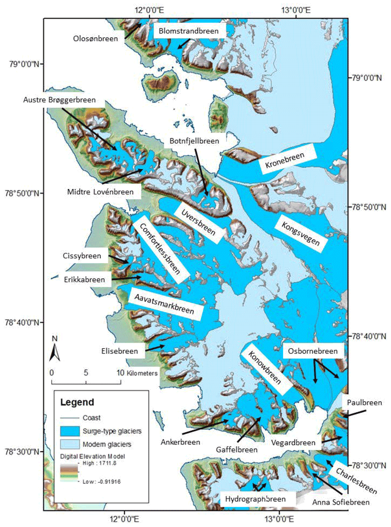
Figure 2Surge-type (labelled with their names) and non-surging glaciers of central western Spitsbergen. Large surge-type glaciers dominate (many of them with tidewater margins), accounting for roughly half of the glaciated area. Glacier outlines and DEM are from the Norwegian Polar Institute. The surge-type glaciers were identified from Sevestre's inventory of Svalbard surging glaciers (Sevestre, 2015).
The area is heavily glacierised, with 78 glaciers covering 69 % of the land area (Fig. 2). There are a wide range of valley and cirque glaciers, as well as 15 large marine-terminating valley or icefield outlet glaciers. The study area features 31 surge-type glaciers, which have phases of comparatively rapid flow (“surges”) interspersed with longer periods of slower flow (Benn and Evans, 2010). The surge-type glaciers in the study area have been identified either due to being observed during a surge or because they are associated with glacial or geomorphological features that are diagnostic of surging (Heïde Sevestre, personal communication, 2015).
Central western Spitsbergen has an Arctic maritime climate, which is typical for Svalbard and produces predominately polythermal bed conditions in all but the smallest of cirque glaciers (Nuth et al., 2007). The study area geology can be broadly divided into three categories: (1) metamorphic Precambrian and Caledonian Hecla Hoek basement around St. Jonsfjorden, to the north of Kongsfjorden, and in the mountains of Oscar II Land; (2) sedimentary Permian and Triassic platform cover on the Brøggerhalvøya peninsula; and (3) Tertiary and Quaternary deposits on the coastal plains of Oscar II Land (Dallmann, 2015; Fig. 1). Previous research has suggested that glacial trimlines can be influenced by the underlying geology (e.g. Kelly et al., 2004), so the varied geology of the study area may be expected to be associated with differing patterns of trimline expression and/or distribution.
2.1 Trimline mapping methodology and data sources
The trimlines of central western Spitsbergen were mapped from remotely sensed imagery using ArcGIS 10.1. The primary mapping was conducted using band 8 (panchromatic) of the Landsat 7 Enhanced Thematic Mapper + scene captured on 1 August 2015. To refine the trimline mapping and to assist in the classification of the modes of trimline expression, the 15 m resolution Landsat scene was compared with very high-resolution (40–50 cm) aerial imagery from the Norwegian Polar Institute (NPI). The aerial images were acquired by the NPI during the summers of 2008–2012. A 20 m resolution digital elevation model (DEM) was also used to provide elevation and slope information for the trimline features and to enable analysis of the surrounding topography. The DEM was produced by the NPI in 2014 from stereo aerial imagery.
Secondary data used in the mapping and analysis of the glacial trimlines included geological maps, acquired from the NPI, and modern glacier margin shapefiles, also acquired from the NPI and produced between 2001 and 2010. A list of the surge-type glaciers in central western Spitsbergen was compiled using Sevestre's Svalbard surging glacier inventory (Sevestre, 2015). Field photographs of several trimlines in central western Spitsbergen were acquired by Mona Henriksen and Camilla M. Rootes during July and August 2015.
All features that could be trimlines or other associated landforms, such as lateral moraines, were identified and mapped onto the Landsat image. Following the terminology outlined in Rootes and Clark (2020), these “apparent trimlines” were then investigated to identify any potentially non-glacial features. This involved consulting the NPI aerial imagery alongside geological and glacier margin maps to identify any apparent trimlines that were likely to be of geological origin, i.e. marking a fault line or rock boundary, or were probably debris-covered ice margins.
2.2 Classifying trimline expression
The new trimline expression classification scheme (Rootes and Clark, 2020; Fig. 3) was applied to the trimlines in the study area. The classification scheme was used to determine the primary mode of expression for each trimline feature and to separate the glacial trimlines from other associated linear landforms, such as moraines and ice marginal meltwater features (Fig. 3).

Figure 3The classification scheme used to determine the mode of expression for glacial trimlines in the study area (Rootes and Clark, 2020). No trimlines were classified in the “invisible trimlines” category. These would need to be identified by analysing soil or rock samples collected in the field, which was beyond the remit of the study. However, all of the remaining trimline expression categories were found to be present in central western Spitsbergen, as well as moraines and ice margin meltwater landforms.
The modes of trimline expression were identified by visual analysis using the Landsat scene and the high-resolution NPI aerial imagery. This technique generally allowed one or more of the expression categories to be easily identified for each trimline. In some cases, it was not possible to clearly identify the primary mode of trimline expression, in which case additional methods were applied. For example, a normalised difference vegetation index (NDVI), computed from the Landsat data, was used to identify the changes in vegetation that characterised some of the surface ageing trimlines in the study area. Other additional methods involved consulting true and false colour Landsat data composites, the DEM, and any available field photos.
The primary mapping identified 407 apparent trimlines, of which 11 were then found to be potentially not glaciogenic landforms. These features were excluded from further analysis, leaving a data set of 396 confirmed glacial trimlines or associated linear glacial features. Of these, 200 apparent trimlines were identified as either moraines or ice marginal meltwater landforms, leaving a final dataset of 196 confirmed glacial trimlines.
Classification of the final dataset determined that the most common mode of expression was as depositional trimlines, such as glacial drift limits, accounting for 93 features, 47 % of all trimlines in the study area. Erosional trimlines, such as limits of warm-based glacial erosion, were also very common; accounting for 90 features or 46 % of all trimlines in the study area. Other modes of expression were found significantly less common, with only eight trimlines expressed primarily as a discontinuity in slope landforms and just five expressed primarily as a contrast in surface ageing. However, both of these less common modes were commonly identified as secondary modes of expression, with either erosional or depositional identified as the feature's primary mode of expression. For example, trimlines primarily identified as depositional were often also found to include discontinuities in slope landforms, whilst primarily erosional trimlines are often associated with surface ageing contrasts. In total, 113 trimlines, representing 58 % of all trimlines in the study area, were identified as composite features that are linked to at least two different modes of expression.
So-called invisible trimlines (Fig. 3), those only apparent from field assessments of relative or absolute dating of the surfaces, were not investigated.
3.1 Trimline distribution and expression
Trimlines were found to be abundant and evenly distributed across the area (Fig. 4a) with most of the modern glaciers having at least one trimline. Four trimlines not associated with any modern glacier were identified: three on Brøggerhalvøya (Fig. 4b) and one in a cirque just west of Comfortlessbreen in Oscar II Land (Fig. 4c). These record the existence of glaciers that likely existed during the Little Ice Age cold event but have since disappeared.
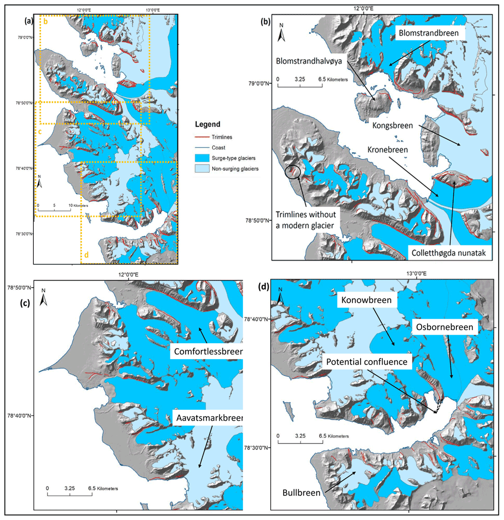
Figure 4Trimlines and glaciers in central western Spitsbergen. (a) Entire study area with areas covered by panels (b), (c) and (d) indicated in orange; (b) greater detail of Kongsfjorden and the Brøggerhalvøya peninsula; (c) coastal Oscar II Land; and (d) the area around St. Jonsfjorden. These maps show that trimlines are found throughout the ice-free areas of central western Spitsbergen, associated with most glaciers, with many glaciers linked to multiple trimlines. The glacier outlines and background DEM are from the NPI.
Further evidence for loss of ice mass in the study area is shown by the altitudinal sequences of trimlines associated with several of the larger glaciers, which indicate widespread glacial thinning. A particularly good example are the trimlines on Colletthøgda, defining a nunatak that is emerging as Kongsbreen and Kronebreen lower in elevation (Fig. 4b). Trimline evidence for frontal retreat of glaciers is apparent in that Bullbreen was once a marine-terminating tidewater glacier, but it has retreated and now terminates on land (Fig. 4d). On the coastal plains of Oscar II Land, trimlines along the lateral ice margins can be used in conjunction with the large lateral and frontal moraine complexes to demonstrate both glacial retreat and thinning in large outlet glaciers, such as Aavatsmarkbreen (Fig. 4c). Trimline evidence also points to former confluences between glaciers that are now distinct. For example, following the line of the trimlines of Konowbreen and Osbornebreen in St. Jonsfjorden allows a potential palaeo-confluence point to be identified (marked in Fig. 4d). In some cases, the distribution of trimlines suggests possible topographic pinning points, where the shape of the topography stabilised a glacier, such as the frontal margin of Blomstrandbreen on the island of Blomstrandhalvøya in Kongsfjorden (Fig. 4b).
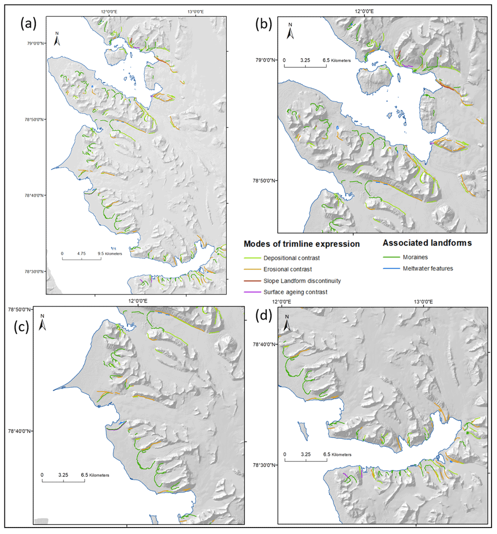
Figure 5Distribution of the different modes of trimline expression and associated ice marginal landforms. (a) Whole study area; (b) Kongsfjorden and Brøggerhalvøya; (c) coast of Oscar II Land; and (d) area around St. Jonsfjorden. Note that many slope landforms and surface ageing trimlines are not visible because the classification here is by the predominant mode of trimline expression, usually erosional or depositional.
Trimlines of all modes of expression are distributed throughout the study area (Fig. 5a). Depositional and erosional trimlines are often found associated with the same glacier and especially so around the surge-type and tidewater glaciers of St. Jonsfjorden (Fig. 5d) and Kongsfjorden (Fig. 5b). Surface ageing contrasts can also be found primarily in St. Jonsfjorden and Kongsfjorden but are particularly common as secondary classifications of erosional trimlines, in which form they are well distributed throughout the study area. Slope landform discontinuities are mainly found alone in Kongsfjorden and are most often identified as a secondary classification for depositional trimlines, in which form they are well distributed throughout the study area but remain the least common mode of trimline expression. Trimlines of all types are less common in the coastal plains in Oscar II Land, where limited numbers of mostly erosional and surface ageing trimlines are largely found on the lateral ice margins (Fig. 5c).
3.2 Factors influencing the distribution and expression
Trimlines are most commonly found (55 %) in the regions of the study area underlain by erosion-resistant Hecla Hoek metamorphic basement, which is found around St. Jonsfjorden, to the north of Kongsfjorden, and in the mountains of Oscar II Land. A further 39 % of trimlines are located on sedimentary Permian and Triassic platform cover on the Brøggerhalvøya peninsula, with just 6 % associated with the soft and highly erodible Tertiary and Quaternary deposits that make up the plains of Oscar II Land. This suggests that the resistance to erosion of the bedrock geology may have an influence over the distribution of glacial trimlines, a link that has been previously made (e.g. by Kelly et al., 2004) but which is fraught with the difficulty of disentangling geological from topographical factors given that the two so often co-vary.
Surface ageing contrasts are especially common (63 %) in regions underlain by the erosion-resistant Hecla Hoek basement. In the regions of softer Tertiary and Quaternary deposits, trimlines are relatively uncommon, but erosional trimlines exist in a slightly greater proportion (12 %) compared to all trimlines (6 %), as might be expected.
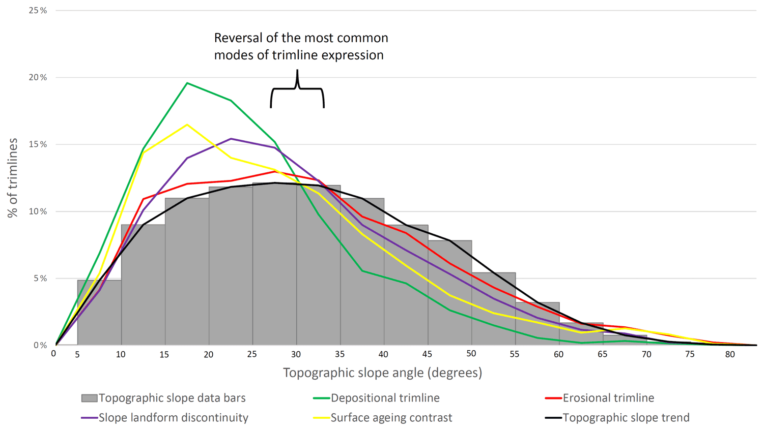
Figure 6Comparison of types of trimline expression (coloured lines) against the slope angle of the ice-free host landscape (bars and black line). Trimlines of all expressions tend to exist on slightly shallower than average slopes in the study area and with notable preferences per type of trimline expression. There is a reversal in the most common mode of trimline expression at around 30∘; below this most trimlines are depositional, whereas the trimlines on steeper slopes are more likely to be expressed as contrasts in erosion, as slope landforms or by surface ageing.
Slope angle appears to be potentially relevant in influencing the distribution of trimlines and their expression. Trimlines are found across almost the full range of ice-free topographic slopes in the study area but are more common on lower slopes (10–30∘) than the typical range of ice-free slope angles (15–35∘) (Fig. 6). Trimlines found on slopes steeper than 30∘ tend to be either erosional, slope landform discontinuities or surface ageing trimlines (Fig. 6). Depositional trimlines can occasionally be found on these steeper slopes, but, as expected, this mode of trimline expression is predominantly found on shallower slopes (< 30∘) (Fig. 6). This reversal in the most common mode of trimline expression at a slope angle of around 30∘ may indicate a relationship between topographic slope and the processes of trimline formation or preservation for specific modes of trimline expression.
Trimlines have been previously described as landforms that can form above the equilibrium line altitude (ELA), making them an important tool for reconstructing palaeo-ice surfaces in glacier accumulation areas (Kelly et al., 2004). The local modern ELA in the study area is thought to be at an elevation of 350 m a.s.l. (Nuth et al., 2007), and 8 % of trimline features were found above this elevation. However, the majority of trimlines are thought to be LIA in origin, when the ELA would likely have been lower. The local ELA at the peak of the LIA is estimated to be at around 273 m a.s.l. (Rootes, 2018). Of the trimlines in the study area, 20 % are located above this altitude. Our mapping thus supports previous findings that trimlines can indeed be formed above the ELA. Depositional trimlines (19 %) and slope landform discontinuities (22 %) are slightly more common above the LIA ELA than erosional trimlines or surface ageing contrasts (11 %), the majority of which are found in the LIA ablation zone.
Regarding glaciological factors potentially influencing timeline expression, the study area usefully contains a mix of marine-terminating tidewater (19 %) and terrestrially terminating glaciers, as well as surge-type (40 %) and non-surging glaciers. The majority (53 %), however, are terrestrial and non-surging. These glaciers will be termed “normal” glaciers to distinguish them from “tidewater” or “surge-type” glaciers.
It might be expected that larger glaciers, having longer perimeters, might produce more trimlines. However, whilst there is a weak correlation between glacier size and number of trimlines, neither glacier area nor glacier length is strongly related to the number of trimlines a glacier produces (r2 < 0.3). This appears to be due to a high degree of variability in the number of trimlines associated with medium and large glaciers, which have lengths > 5 km and areas > 25 000 km2. This variability suggests that another glaciological variable, possibly glacier type, is more important than glacier size for controlling the number of trimlines associated with medium and large glaciers.
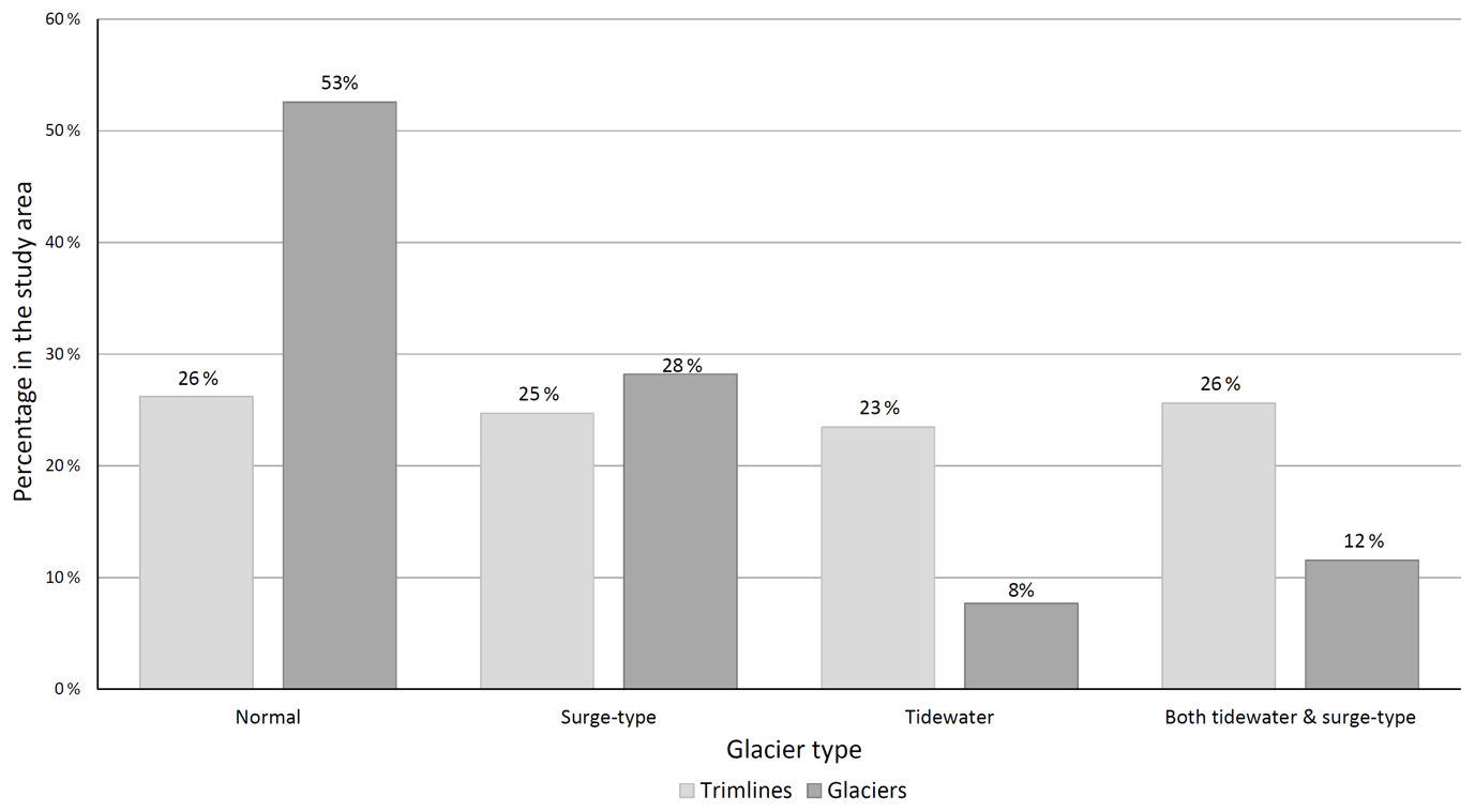
Figure 7Variation in number of trimlines compared with glacier type, scaled according the abundance of each glacier type in the study area. The main signals are that normal glaciers have fewer trimlines than would be expected and that tidewater glaciers (surge and non-surge) have more than expected given the prevalence of these glacier types in the study area.
The number of trimline features associated with each glacier type was compared to the relative abundance of that glacier type in the study area (Fig. 7). This shows that normal glaciers, despite being the most common type of glacier in the study area (53 %), have a lower proportion of trimlines (26 %) than the other glacier types. Both tidewater and tidewater surge-type glaciers, on the other hand, produce many more trimlines than would be expected given the proportion of these glaciers in the study area. Tidewater glaciers account for 23 % of all trimline features but only 8 % of study area glaciers, whilst tidewater surge-type glaciers produce 26 % of all trimlines from 12 % of glaciers. This suggests that the behaviour or glaciology of tidewater glaciers may promote trimline formation and/or preservation.
Comparing the mode of trimline expression to the type of glacier also suggests a connection between glacier type and how trimlines are expressed. Depositional trimlines exist across all glacier types in roughly equal proportion to their relative abundance, but some other modes of expression are associated with particular glacier types. Erosional trimlines and surface ageing contrasts are slightly more commonly associated with surge-type glaciers compared to non-surging glaciers, but a much stronger connection appears to exist between these modes of trimline expression and tidewater glaciers. Tidewater glaciers, both surge-type and non-surging, are associated with 38 % of all trimlines, but these are predominately erosional trimlines (62 %) or surface ageing contrasts (60 %). Marine-terminating glaciers appear to promote the formation or preservation of these particular modes of trimline expression.
It is clear that the distribution of glacial trimlines in the area records a wealth of information about the former size, shape and configuration of the local glaciers and is a valuable record of glacier recession.
4.1 Insights into trimline formation and preservation
Glacial trimlines have been shown to be present both above the modern ELA and above the LIA ELA in central western Spitsbergen. This supports previous suggestions that trimlines can form in the accumulation areas of glaciers (Kelly et al., 2004) and makes these landforms valuable constraints on the vertical dimensions of palaeo-ice masses. This is important for 3D reconstructions and enables the potential to determine rates of thinning in both the ablation and accumulation areas.
Geology, topography and glacier type all appear to influence the distribution and expression of glacial trimlines in central western Spitsbergen. This suggests that these factors may act as controls over either the processes of trimline formation, their preservation or both. Whilst difficult to disentangle between these variables, it appears that underlying geology and glacier type exert a stronger influence than topography on the distribution and expression of glacial trimlines. That trimlines of all expressions are found across nearly the full range of topographic slope angles in the study area may indicate that slope angle is not a strong control over the formation and preservation of glacial trimlines. Since topographic slope may be linked to the rates and mechanics of ice flow and the rates of erosion or deposition of a glacier, it could be that any relationship between trimlines and topographic slope is more a reflection of glaciology than topography.
Alternatively, the location of shallow slope angles within glacial valleys, rather than the slope angle itself, could be the primary influence of topography over glacial trimlines. For example, depositional trimlines may only form where there is sufficient glacially transported material to build a drift limit, which may only be the case at the downstream end of the valley, coinciding with the location of shallower slope angles.
Geology appears to exert a stronger influence than topography, with a clear link identifying a higher prevalence of trimlines in areas of more resistant bedrock. This suggests that trimlines may be better preserved in these environments, a point also made by Kelly et al. (2004) in their study of trimlines in the European Alps. Kelly et al. (2004) also found that erosional trimlines in particular were more common in areas of more resistant bedrock. Erosional trimlines often manifest as a boundary between areas of glacial erosion and regions of periglacial weathering. Therefore, these features may not preserve well in more erodible sediments, where other processes (e.g. fluvial action, mass wasting) could remove or cover erosional trimlines. However, this study has found that, whilst no trimlines were particularly common in the areas of the most easily eroded geology, erosional trimlines were actually the most common mode of expression in these regions. It is hypothesised that this may be due to the relatively young LIA age of the trimlines in central western Spitsbergen compared to the older Last Glacial Maximum trimlines studied by Kelly et al. (2004). It may be that erosional trimlines form relatively easily in areas of more erodible geology but that they are not well preserved in these settings, explaining their relative abundance in these settings on Svalbard compared to areas with older trimline features. The lack of other modes of trimline expression in the coastal area of Oscar II Land, where the geology is very erodible, could indicate that the formation or preservation of most trimlines is hampered by less resistant rocks and sediments. In particular, surface ageing contrasts are likely to take a long time to form and may either not form at all or not be preserved in more rapidly eroding environments, which may explain why these features are markedly more common in the areas of resistant Hecla Hoek basement. Slope landform discontinuities require the presence of existing slope landforms, such as talus cones or gullies, in order to form. These landforms are perhaps less likely to form in areas with softer bedrock because the topography is more likely to be subdued, without steep slopes that encourage the mass wasting and fluvial processes required to form slope landforms.
The finding that tidewater glaciers produced more trimlines than terrestrial glaciers might be due to their greater ice flow velocities, which promote higher levels of glacial erosion and create more material that is then available for glacial deposition. Whilst tidewater surge-type glaciers produced larger numbers of trimlines than might be expected from the number of glaciers, the same is not true of terrestrial surge-type glaciers (Fig. 7). This might be because surge-type glaciers only have high velocities for short periods of time, generally 3–10 years for Svalbard surge-type glaciers, with lower velocities during quiescent phases of 50–500 years (Sevestre and Benn, 2015; Dowdeswell et al., 1991). It appears that high ice flow velocities do not promote greater numbers of trimlines unless velocities are sustained for extended periods of time, as is the case for most tidewater glaciers but not for terrestrial surge-type glaciers.
Erosional and surface ageing trimlines are much more likely to be associated with tidewater glaciers, both surge-type and non-surging. This connection is probably due to the high velocities of these glaciers which promote the processes of glacial erosion that produce these modes of trimline expression.
In summary, we have identified some potentially useful links between the distribution of glacial trimlines, different modes of trimline expression, the underlying geology and the type of glacier. These relationships, if found to hold in further research in a wider range of settings, could enable a more confident interpretation of trimlines and may enable more information to be extracted from them, analogous to landsystem models that have been constructed for terrestrial (Evans and Rea, 2003) and tidewater (Ottesen et al., 2008) surging glaciers in Svalbard. Can trimlines be reliably added to such models?
4.2 Assessment of the trimline expression classification
A new classification scheme for trimline expression (Fig. 3; Rootes and Clark, 2020) was applied here in a case study. No trimlines were identified that could not be matched with one of the modes of trimline expression listed in the classification scheme. In all cases, remotely sensed satellite and aerial images were the primary data used to identify trimline expression, which was carried out by eye. Even when using the lower-resolution (15 m) Landsat imagery, the system worked well and was accurate when compared to the higher-resolution (40–50 cm) aerial images. Identification of the mode of trimline expression using satellite imagery was aided by the use of minor post-processing to produce composite images, particularly true and false colour images and to conduct NDVI analyses. The use of the digital elevation model (DEM) also assisted in identifying the mode of trimline expression, particularly by altering the angle of illumination in relief shading tools across the trimline. It is therefore recommended that the trimline expression classification system is used with aerial imagery where possible, but it can be applied to lower-resolution satellite imagery, in which DEMs and compound images can be utilised to aid the classification process.
Whilst it was generally possible to separate the different modes of trimline expression, a majority of trimlines (58 %) were found to be expressed in more than one way – these features are referred to as “composite trimlines”. The composite trimlines were classified according to their most dominant expression, which was generally easy to identify, but this was necessarily a subjective decision. The most common composite trimlines were dominantly erosional or depositional contrasts, combined with either slope landform discontinuities or surface ageing contrasts. Although the slope landform and surface ageing modes of trimline expression were most commonly used as secondary classifications, both of these modes of expression were found as the sole classification for some trimline features. This suggests that it is worth continuing to identify these modes of expression as distinct from erosional or depositional trimlines.
Overall, the trimline expression classification system was easy to use with both satellite and aerial imagery, although it is best used with higher-resolution images. Utilising DEMs and composite images works well to improve the accuracy of trimline expression classification without significantly adding to the workload required. The insights drawn from exploring the expression of trimlines in central western Spitsbergen suggest that more widespread consideration of the expression of glacial trimlines is likely to be worthwhile. Therefore, the expression classification presented in Rootes and Clark (2020) is recommended as a tool to explore glacial trimline expression, although it would benefit from being tested in more locations. Whilst more time consuming for large areas, field investigation of trimlines can include other types of evidence not visible from remotely sensed data, such as the variable spreads of erratic blocks or striae inscribed on bedrock.
Previous research into glacial trimlines has generally not considered the full range of possible trimline expressions, and little attempt has been made to explore the processes of trimline formation and preservation. Rootes and Clark (2020) reviewed the literature of glacial trimline research and suggested a new classification scheme for the various modes of trimline expression (Fig. 3). Here we applied this classification scheme for the first time, using it to investigate glacial trimlines in central western Spitsbergen. Trimlines and associated ice marginal landforms were mapped from aerial and satellite imagery (Fig. 4a) and classified according to the expression classification presented by Rootes and Clark (2020) (Fig. 5a). The classification was found to be straightforward to apply to the remotely sensed imagery and included all of the observable modes of trimline expression in the study area. It is suggested that further applications of the trimline expression classification in a wider range of settings may prove fruitful at illuminating processes of trimline formation and preservation, an area that has seen only limited research.
Preliminary exploration of the possible factors influencing trimline distribution and expression found that the type of glacier and geology, particularly bedrock erodibility, appears to exert control over the distribution and expression of glacial trimlines. Topographic factors were found to have less impact. The findings of this study suggest that analysis of the expression and distribution of glacial trimlines has the potential to shed light on the type of glacier that formed the trimlines, potentially enabling the identification of surge-type and tidewater glaciers in Quaternary settings. This study has also confirmed that trimlines can be formed above the ELA, supporting the conclusions of previous research and validating the use of these features as indicators of palaeo-ice thickness in the accumulation area.
A better understanding of trimline formation and preservation could lead to a significant expansion in the potential uses for glacial trimlines in palaeoglaciological reconstructions. Where previously trimlines have been used only as a constraint on the ice margin position and as a measure of ice thickness, they can now potentially be used to diagnose the type of glacier, but further research is required to confirm this.
GIS data of the identified trimlines are not yet available because analysis is ongoing but will be available via a data repository or by request from the second author.
CMR was responsible for the conceptualisation, methodology, investigation, formal analysis, and writing the original draft and producing the figures. CDC was responsible for the conceptualisation, methodology, writing (review, editing and additions), for supervising the PhD, and for submitting and handling the paper.
The contact author has declared that neither they nor their co-author has any competing interests.
Publisher’s note: Copernicus Publications remains neutral with regard to jurisdictional claims in published maps and institutional affiliations.
Camilla M. Rootes carried out this work whilst in receipt of a PhD scholarship awarded to her by the Faculty of Social Sciences at the University of Sheffield, and she gratefully acknowledges this support. This work has benefited from funding from the European Research Council (ERC) under the European Union's Horizon 2020 research and innovation programme as part of the PalGlac project (grant agreement no. 787263).
This research was supported by a University of Sheffield PhD scholarship scheme and with funding from the European Research Council (ERC) under the European Union's Horizon 2020 research and innovation programme as part of the PalGlac project to Christopher D. Clark (grant agreement no. 787263).
The article processing charge was funded by the Quaternary scientific community, as represented by the host institution of EGQSJ, the German Quaternary Association (DEUQUA).
This paper was edited by Christopher Lüthgens and reviewed by Margot Böse and one anonymous referee.
Ballantyne, C. K.: Extent and deglacial chronology of the last British-Irish Ice Sheet: implications of exposure dating using cosmogenic isotopes, J. Quat. Sci., 25, 515–534, 2010.
Barr, I. D. and Lovell, H.: A review of topographic controls on moraine distribution, Geomorphology, 226, 44–64, 2014.
Benn, D. I. and Evans, D. J.: Glaciers and glaciation, Hodder Education, ISBN 9781138458130, 2010.
Cooley, S. W.: Degradation of moraine slopes with age in Quaternary moraines of eastern California, in: Geological Society of America Abstracts with Programs, p. 1, Geological Society of America, https://our.unc.edu/abstract/cooley-degradation-of-moraine-slopes-with-age-in-quaternary-moraines-of-eastern-ca/ (last access: 7 June 2022), 2012.
Dallmann W. K. (Ed.): Geoscience Atlas of Svalbard, Norwegian Polar Institute, Report 148, Tromsø, http://hdl.handle.net/11250/2580810 (last access: 7 June 2022), 2015.
Dowdeswell, J., Hamilton, G., and Hagen, J.: The duration of the active phase on surge type glaciers: Contrasts between Svalbard and other regions, J. Glaciol., 37, 388–400, 1991.
Evans, D. and Rea, B.: Glacial Landsystems, in: Glacial Landsystems, edited by: Evans, D. J. A., Arnold, London, 259–288, ISBN 9780203784976, 2003.
Farnsworth, W. R., Allaart, L., Ingólfsson, Ó., Alexanderson, H., Forwick, M., Noormets, R., Retelle, M., and Schomacker, A.: Holocene glacial history of Svalbard: Status, perspectives and challenges, Earth-Sci. Rev., 208, 103249, https://doi.org/10.1016/j.earscirev.2020.103249, 2020.
Flink, A. E., Noormets, R., Kirchner, N., Benn, D. I., Luckman, A., and Lovell, H.: The evolution of a submarine landform record following recent and multiple surges of Tunabreen glacier, Svalbard, Quat. Sci. Rev., 108, 37–50, 2015.
Ingólfsson, Ó.: Fingerprints of Quaternary glaciations on Svalbard, Geological Society, London, Special Publications, 354, 15–31, https://doi.org/10.1144/SP354.2, 2011.
Kelly, M. A., Buoncristiani, J.-F., and Schlüchter, C.: A reconstruction of the last glacial maximum (LGM) ice-surface geometry in the western Swiss Alps and contiguous Alpine regions in Italy and France, Eclogae Geol. Helv., 97, 57–75, 2004.
Kohler, J., James, T. D., Murray, T., Nuth, C., Brandt, O., Barrand, N. E., Aas, H. F., and Luckman, A.: Acceleration in thinning rate on western Svalbard glaciers, Geophys. Res. Lett., 34, L18502, https://doi.org/10.1029/2007GL030681, 2007.
Lønne, I. and Lyså, A.: Deglaciation dynamics following the Little Ice Age on Svalbard: Implications for shaping of landscapes at high latitudes, Geomorphology, 72, 300–319, 2005.
Lukas, S.: Processes of annual moraine formation at a temperate alpine valley glacier: insights into glacier dynamics and climatic controls, Boreas, 41, 463–480, 2012.
Lukas, S., Graf, A., Coray, S., and Schlüchter, C.: Genesis, stability and preservation potential of large lateral moraines of Alpine valley glaciers – towards a unifying theory based on Findelengletscher, Switzerland, Quat. Sci. Rev., 38, 27–48, 2012.
Mangerud, J. and Landvik, J. Y.: Younger Dryas cirque glaciers in western Spitsbergen: smaller than during the Little Ice Age, Boreas, 36, 278–285, 2007.
Navarro, F. J., Glazovsky, A. F., Macheret, Y. Y., Vasilenko, E. V., Corcuera, M. I., and Cuadrado, M. L.: Ice-volume changes (1936–1990) and structure of Aldegondabreen, Spitsbergen, Ann. Glaciol., 42, 158–162, 2005.
Nuth, C., Kohler, J., Aas, H. F., Brandt, O., and Hagen, J. O.: Glacier geometry and elevation changes on Svalbard (1936–90): a baseline dataset, Ann. Glaciol., 46, 106–116, 2007.
Ottesen, D., Dowdeswell, J. A., Benn, D. I., Kristensen, L., Christiansen, H. H., Christensen, O., Hansen, L., Lebesbye, E., Forwick, M., and Vorren, T. O.: Submarine landforms characteristic of glacier surges in two Spitsbergen fjords, Quat. Sci. Rev., 27, 1583–1599, 2008.
Reinardy, B. T., Leighton, I., and Marx, P. J.: Glacier thermal regime linked to processes of annual moraine formation at Midtdalsbreen, southern Norway, Boreas, 42, 896–911, 2013.
Rootes, C. M.: The nature and use of trimlines for analysing 3-dimensional glacier change in rugged terrain, PhD thesis, unpublished, The University of Sheffield, 2018.
Rootes, C. M. and Clark, C. D.: Glacial trimlines to identify former ice margins and subglacial thermal boundaries: A review and classification scheme for trimline expression, Earth-Sci. Rev., 210, 103355, https://doi.org/10.1016/j.earscirev.2020.103355, 2020.
Sevestre, H.: Surge-type glaciers: controls, processes and distribution, PhD thesis, unpublished, The University Centre in Svalbard & University of Oslo, 2015.
Sevestre, H. and Benn, D. I.: Climatic and geometric controls on the global distribution of surge-type glaciers: implications for a unifying model of surging, J. Glaciol., 61, 646–662, 2015.
Ziaja, W.: Response of the Nordenskiöld Land (Spitsbergen) glaciers Grumantbreen, Håbergbreen and Dryadbreen to the climate warming after the Little Ice Age, Ann. Glaciol., 42, 189–194, 2005.