Articles | Volume 71, issue 2
https://doi.org/10.5194/egqsj-71-267-2022
Research article
 | 
22 Dec 2022
Research article |  | 22 Dec 2022

Tunnel valleys in the southeastern North Sea: more data, more complexity

Arne Lohrberg, Jens Schneider von Deimling, Henrik Grob, Kai-Frederik Lenz, and Sebastian Krastel
How to cite

Lohrberg, A., Schneider von Deimling, J., Grob, H., Lenz, K.-F., and Krastel, S.: Tunnel valleys in the southeastern North Sea: more data, more complexity, E&G Quaternary Sci. J., 71, 267–274, https://doi.org/10.5194/egqsj-71-267-2022, 2022.

Abstract

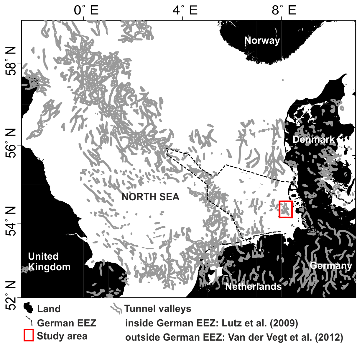
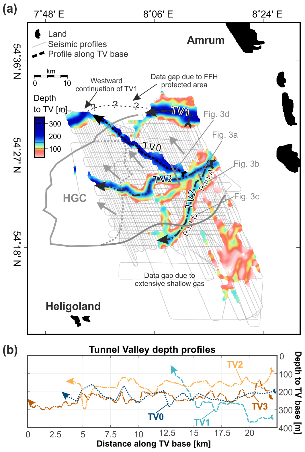
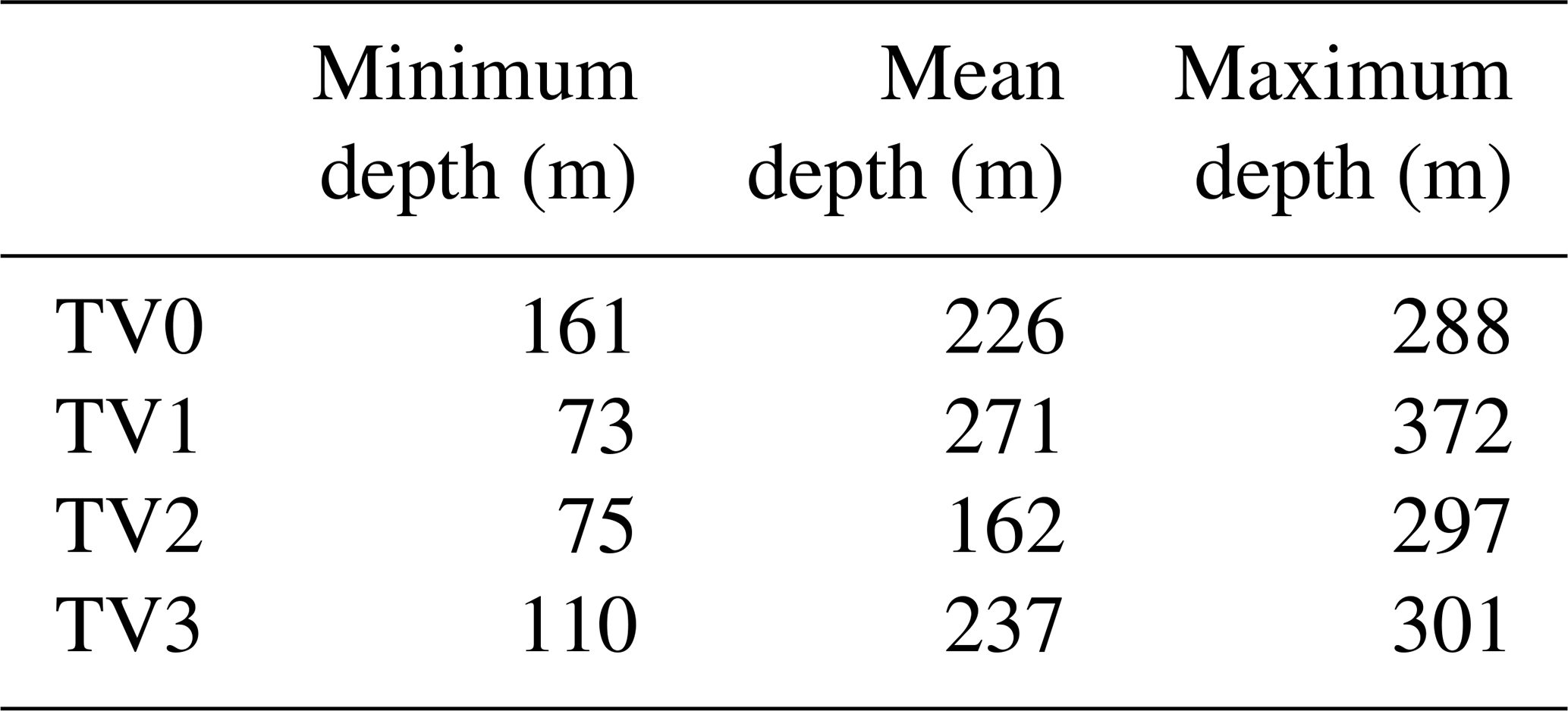
Large Pleistocene ice sheets have produced glacial structures both at and below the surface in northern Europe. Some of the largest and most erosive structures are so-called tunnel valleys (TVs): large and deep channels (typically up to 5 km wide and up to 400 m deep, with lengths up to 100 km), which formed below ice sheets. Although the subject of many studies, the details of their formation and fill are still not well understood. Here, we present an update on the distribution of TVs in the southeastern North Sea between Amrum and Heligoland based on a very dense grid of high-resolution 2D multi-channel reflection seismic data (400 m line spacing). The known tunnel valleys (TV1–TV3) in that area can now be traced in greater detail and further westwards, which results in an increased resolution and coverage of their distribution. Additionally, we were able to identify an even deeper and older tunnel valley, TV0, whose orientation parallels the thrust direction of the Heligoland Glacitectonic Complex (HGC). This observation implies a formation of TV0 before the HGC during an early-Elsterian or pre-Elsterian ice advance. For the first time, we acquired high-resolution longitudinal seismic profiles following the thalweg of known TVs. These longitudinal profiles offer clear indications of an incision during high-pressure bank-full conditions. The fill indicates sedimentation in an early high-energy environment for the lower part and a subsequent low-energy environment for the upper part. Our results demonstrate that a very dense profile spacing is required to decipher the complex incisions of TVs during multiple ice advances in a specific region. We also demonstrate that the time- and cost-effective acquisition of high-resolution 2D reflection seismic data holds the potential to further our understanding of the incision and filling mechanisms as well as of the distribution, complexity and incision depths of TVs in different geological settings.

Kurzfassung

Große pleistozäne Eisschilde haben in Nordeuropa glaziale Strukturen sowohl an der Oberfläche als auch unter der Oberfläche hinterlassen. Einige der größten und erosivsten Strukturen sind sogenannte Tunneltäler (TV); große und tiefe Rinnen (typischerweise bis zu 5 km breit, bis zu 400 m tief, mit einer Länge von bis zu 100 km), die sich unter Eisschilden gebildet haben. Die Bedingungen ihrer Entstehung und Verfüllung sind jedoch noch immer nicht genau verstanden. Hier zeigen wir eine Erweiterung der Verteilung von Tunneltälern in der südöstlichen Nordsee zwischen Amrum und Helgoland auf der Grundlage eines sehr dichten Netzes von hochauflösenden 2D-Mehrkanal-Reflexionsseismikdaten (400 m Profilabstand). Die bekannten Tunneltäler (TV1–TV3) in diesem Gebiet können nun detaillierter und weiter westlich verfolgt werden, was zu einer erhöhten Auflösung und Abdeckung ihrer Verteilung führt. Darüber hinaus konnten wir ein tieferes und älteres Tunneltal TV0 identifizieren, dessen Ausrichtung parallel zur Schubrichtung des Helgoland Glazialtektonischen Komplex (HGC) verläuft. Diese Beobachtung deutet auf eine Entstehung von TV0 vor dem HGC während eines früh- oder vor-elsterzeitlichen Eisvorstoßes hin. Zum ersten Mal haben wir hochauflösende seismische Profile genau entlang des Verlaufs der bekannten Tunneltäler aufgenommen. Diese Längsprofile liefern eindeutige Hinweise auf einen Einschnitt unter hohen Drücken. Die Füllung deutet auf eine Sedimentation während einer frühen hochenergetischen Phase für den unteren Teil und einer nachfolgenden niederenergetischen Phase für den oberen Teil hin. Unsere Ergebnisse zeigen, dass ein sehr dichter Profilabstand erforderlich ist, um die komplexen Einschnitte von Tunneltälern während mehrerer Eisvorstöße in einer ausgewählten Region zu entschlüsseln. Wir zeigen auch, dass die zeit- und kosteneffiziente Erfassung von hochauflösenden 2D-reflexionsseismischen Daten das Potenzial hat, unser Verständnis für die Erosions- und Füllmechanismen sowie für die Verteilung, Komplexität und Einschnitttiefen von Tunneltälern in verschiedenen geologischen Umgebungen zu verbessern.

Dates
1 Introduction

Extensive seismic studies have shown a high abundance of subglacially produced channels – so-called tunnel valleys (TVs) – in many regions of the North Sea (Fig. 1; Huuse and Lykke-Andersen, 2000; Lonergan et al., 2006; Kristensen et al., 2007; Lutz et al., 2009; Andersen et al., 2012; Hepp et al., 2012; Stewart et al., 2013; Lohrberg et al., 2020; Kirkham et al., 2021). TVs typically have widths of 1 to 5 km, incision depths of up to 400 m and lengths of up to 100 km (van der Vegt et al., 2012). Widths of up to 10 km and depths of up to 500 m have been observed locally in the North Sea (Ottesen et al., 2020). In the German sector of the North Sea in particular, Lutz et al. (2009) reported lengths of up to 60 km, widths of up to 8 km and depths of up to 400 m. Most of these TVs are now filled with sediments and often buried beneath a drape of glacial and interglacial deposits. The evaluation of their distribution with respect to different subsoil conditions may provide details on their incision process assuming that glacial conditions may have been comparable for larger regions of the North Sea. Constraints on the maximum incision depth and widths of TVs are needed to evaluate the long-term stability and safety of subsurface storage sites in formerly glaciated terrain due to the potential of direct hydraulic connections to otherwise sealed systems as a consequence of erosion and subsequent filling. Considering that glaciations of similar magnitude to those of the Pleistocene are likely to occur in the future (Loutre and Berger, 2000), this factor has increased in significance during the site selection process for radioactive waste. This is due to the fact that radioactive waste has half-lives of millions of years, such that German legislation requires safe storage for at least 1 million years.

https://egqsj.copernicus.org/articles/71/267/2022/egqsj-71-267-2022-f01

Figure 1Location of the study area and distribution of tunnel valleys (TVs) in the North Sea and adjacent countries (adapted from Lohrberg et al., 2020).

Many stages of advancing and retreating ice sheets are known from the Pleistocene and correlated with the so-called marine isotope stages (MISs) derived from the analysis of ice and sediment cores all over the globe. Using the MISs, the remnants of glacially produced structures were used to correlate the cover of ice sheets in different regions during different stages of glaciations. In particular, the Scandinavian Ice Sheet (SIS) advanced into the North Sea during MIS 2 (Weichsel), MIS 6–8 (Saale), MIS 10 (Elster) and possibly MIS 16 (Cromer) (Ehlers, 1990; Ehlers et al., 2011; Batchelor et al., 2019). Only the latest glaciation during MIS 2 did not result in the full coverage of the North Sea as evidence for Weichselian ice sheets is missing in the southeastern North Sea (Batchelor et al., 2019).

Based on 3D seismic data, several authors showed that TVs often cross-cut and that they exist in different stratigraphic levels, such that a sequence of their formation can be derived (Kristensen et al., 2007, 2008; Stewart and Lonergan, 2011; Kirkham et al., 2021). In fact, Stewart and Lonergan (2011) were able to show that the formation of all TVs in their study area in the central North Sea can be correlated with at least seven phases of ice advance-and-retreat cycles in different directions. These results imply that TVs tend to form in multiple phases during a number of ice advances. As a consequence, a clear attribution of single TVs to the maximum extents of the three major ice advances in the North Sea (i.e. Elster, Saale and Weichsel) is not feasible. Instead, the occurrence of different phases of TVs likely represents a multitude of different ice advances and ice lobes in a specific area (Kehew et al., 1999).

The multitude of extensive 3D and high-resolution 2D seismic data provided good detail on the distribution of TVs in the North Sea (Huuse and Lykke-Andersen, 2000; Kristensen et al., 2007; Lutz et al., 2009; Stewart et al., 2013; Ottesen et al., 2020). Yet, this distribution has wide blank spots where costly 3D seismic data are not available and where 2D seismic data were acquired with a focus on potentially hydrocarbon-bearing structures hundreds of metres deeper than Pleistocene sediments. Extensive high-resolution 2D seismic studies using dense profile spacing of 800 m or less were able to show that a high-density 2D approach is well suited to assessing buried TVs (Hepp et al., 2012; Lohrberg et al., 2020). Here, we provide an update of the tunnel valley distribution between Amrum and Heligoland in the southeastern North Sea (Lohrberg et al., 2020; Fig. 2a). For the first time, we have acquired longitudinal seismic profiles following the thalweg of known TVs to image their fill over several kilometres in high resolution and to evaluate existing hypotheses for the incision and filling mechanism.

https://egqsj.copernicus.org/articles/71/267/2022/egqsj-71-267-2022-f02

Figure 2Overview of the study area. (a) Detailed distribution of large tunnel valleys (TVs) in the study area in the form of a depth grid based on all available high-resolution 2D reflection seismic profiles (with the sea level as depth reference). The limits of the Heligoland Glacitectonic Complex (HGC) are plotted for reference, where the arrows indicate the thrust direction towards the northwest (Winsemann et al., 2020; Lohrberg et al., 2022). (b) Depth profiles for the base of TV1–TV3 inferred from longitudinal seismic profiles following the thalweg of the TVs. Note that the depth profile for TV0 has been generated from the updated tunnel valley grid as it was unknown during data acquisition.

2 Materials and methods

We acquired 2D reflection seismic data to image subsurface structures and landforms from 0 to 800 ms two-way travel time (approximately 600 m) beneath the seafloor between Amrum and Heligoland in the southeastern North Sea. During cruise AL496 with R/V Alkor in July 2017, we acquired a total of 1058 km of 2D high-resolution multi-channel reflection seismic data in a closely spaced 2D grid covering approximately 800 km2 with a mean profile spacing of 800 m. During cruise MSM98/2 with R/V Maria S. Merian in February 2021, we acquired an additional 1600 km of 2D high-resolution multi-channel reflection seismic data filling the gaps of the previous survey (AL496) to achieve a combined line spacing of approx. 400 m and to extend the data set westwards. Based on earlier results (Lohrberg et al., 2020), we were able to plan selected survey lines precisely along the thalweg of known TVs to produce longitudinal seismic profiles.

The acquisition setup and data processing were highly similar for both surveys, and details are described in Lohrberg et al. (2020, 2022). We used a sound velocity of 1600 m s−1 for the depth conversion for lack of a detailed velocity model, and depths are provided in reference to the water level. The frequencies used to image the subsurface range between 70 and 1000 Hz with the main frequency around 300 Hz, which results in a vertical resolution in the metre range for the upper tens of metres below the seafloor, whereas the resolution decreases with increasing penetration due to the absorption of high frequencies.

The fully processed seismic sections were loaded into IHS Markit Kingdom software (2018) for interpretation. The Kingdom software was used to trace the horizons and the morphology of the subsurface landforms. The horizons were then exported for interpolation and plotting using the Generic Mapping Tools (GMT) open-source software.

3 Results

We updated our previous results for the distribution of TVs for the study area (Lohrberg et al., 2020) using the newly acquired data, which resulted in an updated map (Fig. 2a). Due to the increased profile density, we were able to close gaps that previously led to an ambiguous tracing of the TVs. Although similar to the results of Lohrberg et al. (2020), the updated map allows for the tracing of previously identified TV1, TV2 and TV3 in greater detail and approx. 10 km farther towards the west. Based on the updated map, we are confident that we imaged the westward continuation of TV1 in the northwest of the study area (Fig. 2a). Furthermore, TV2 can now be traced along its thalweg over 17 km and TV3 can now be traced along 22 km (Fig. 2b). Owing to the increased profile density, we were able to identify a new tunnel valley, TV0, which lies in a deeper stratigraphic level than TV1–TV3. The average depth of its thalweg is around 250 m, and the thalweg shows minor undulation. The fill of TV0 shows less stratification, yet it can be separated into a lower and an upper part in some profiles, despite strongly undulating reflectors in its upper part. Its flanks show more gentle slopes than the flanks of TV1–TV3, and both its beginning and its end have been crossed and eroded by other TVs. In contrast to TV1–TV3, TV0 does not show clear “shoulders” at its top, and its orientation differs. TV0 is oriented in a SE–NW direction and therefore parallels the identified thrust direction of the Heligoland Glacitectonic Complex (HGC) towards the northwest postulated in that area (Fig. 2; Winsemann et al., 2020; Lohrberg et al., 2022).

https://egqsj.copernicus.org/articles/71/267/2022/egqsj-71-267-2022-f03

Figure 3Seismic sections showing transverse and longitudinal profiles of a tunnel valley (TV2). The location of the profiles is indicated in Fig. 2a. (a) Typical transverse profile imaging TV2 perpendicular to its thalweg. (b) Part A and (c) Part B of a longitudinal profile following the thalweg of TV2 known from earlier results. (d) Transverse profile imaging TV0 and TV3 perpendicular to their thalweg. Turns of the ship needed to follow the TV introduce a slight decrease into the imaging quality and are marked in the figure. TV#e# refers to the respective erosional base of the respective upper or lower fill of the TV denoted as TV#f#, where # denotes a number.

Download

For the first time, we were able to generate high-resolution seismic profiles oriented along the thalweg of TVs by planning profiles based on earlier results (Lohrberg et al., 2020). Figure 3a shows a typical transverse profile of TV2 in which the TV infill can be delineated into two parts based on its acoustic properties (TV2f1 and TV2f2). Figure 3b and c display longitudinal profiles following TV2's thalweg, in which we traced the base of the two fills (TV2e1 and TV2e2). From Fig. 3b and c it is evident that TV2's thalweg (TV2e1) significantly undulates along the profile. The depth profiles for the thalwegs of TV1–TV3 are shown in Fig. 2b for comparison, and Table 1 provides basic values for the incision depth with respect to sea level. Based on our data, it is clear that TV2 incised through Miocene and late Paleogene strata while overcoming significant barriers of over 75 m height difference during incision (Fig. 3b and c). Part A of the longitudinal profile following TV2 (Fig. 3b) shows increased undulation and partly very deep incision of the thalweg. The dip of the thalweg parallels the dip of the underlying strata in limited areas with frequent deeper incisions on several occasions (Fig. 3b and c). The base of the upper fill (TV2f2) follows this trend and undulates more strongly in areas of deeper incision (Fig. 3b). Part B further towards the west of the study area shows slightly less undulation of the thalweg and an almost flat base of the upper fill (TV2f2; Fig. 3c). Neither TV2f1 nor TV2f2 shows a distinct stratigraphic pattern, except for a faint layering, which follows TV2e2. Excluding the undulation of the thalweg (TV2e1), the mean incision depth of TV2 is close to 160 m over the whole course of the TV, despite a significant dip of the underlying strata towards the west (Fig. 3b and c).

Table 1Basic values for the incision depth of the largest TVs in the study area with respect to sea level.

Download Print Version | Download XLSX

4 Discussion and conclusions

Different incision mechanisms have been described for TVs, and there has long been a debate about whether the incision could be explained with fluvial erosion (Donovan, 1972; Salomonsen, 1995; Sørensen and Michelsen, 1995) or whether pressurized subglacial erosion is the more likely mechanism (Jentzsch, 1884; Kuster and Meyer, 1979; Piotrowski, 1994). Our high-resolution longitudinal profiles along a single-incision TV show that the incision has overcome significant morphological highs of over 75 m over a 500 m distance, which is a significant gradient when compared to earlier studies by Stewart et al. (2013), who showed a maximum gradient of approx. 100 m over a 1 km distance. These large gradients are impossible to reconcile with a gravity-driven fluvial erosion, as any water flow would stagnate at either of the morphological barriers (Ó Cofaigh, 1996; van der Vegt et al., 2012). Therefore, we conclude that fluvial erosion is not the primary process that led to the formation of the TVs in our study area. Instead, we conclude and confirm interpretations that bank-full pressurized drainage beneath an ice sheet was responsible for their formation (Piotrowski, 1994; Huuse and Lykke-Andersen, 2000) as bank-full conditions would be capable of overflowing such barriers. High hydraulic heads beneath kilometre-thick ice sheets in combination with abrasion at their base provided a high efficiency for the erosion of the underlying strata. Based on the morphology of the thalweg and on the lower fill of the TVs alone, we are unable to answer whether the incision followed a “catastrophic” or rather a longer-term “steady-state” erosion process. Yet, the strongly undulating thalweg and barriers can be seen as strong indications of different stages of catastrophic erosion during different cycles of glacier retreat and advance, which would directly control the meltwater pressures at the base. Because of these observations, we consider a catastrophic meltwater outburst scenario more likely than steady-state erosion of the thalweg.

Following their incision, most TVs of the North Sea have been filled. Contrary to our expectation, we do not observe patterns that are a diagnostic for specific sedimentary processes in the fill of the TVs along their thalweg, except for a segmentation into an upper part with increased stratification and a lower part with decreased or absent stratification (TV2f1, TV2f2; Fig. 3b and c). In particular, we do not observe clinoforms or other structures postulated before as a diagnostic for the process of “backfilling” (Praeg, 1996), which refers to the near-simultaneous up-ice-directed meltwater erosion and deposition of the soil during ice sheet retreat. Rather the increased stratification in the fill's upper part (TV2f2) indicates a contemporaneous filling of the valley in a low-energy environment, possibly paralleling water level rise during melting ice sheets (Piotrowski, 1994; Huuse and Lykke-Andersen, 2000; Stewart et al., 2012; van der Vegt et al., 2012). Considering the decreased stratification in the lower part of the fill (TV2f1), we consider it likely that the early/lower fill of the TVs was deposited in a high-energy environment, which explains larger and less sorted grain sizes, such as coarse sands, gravels and boulders, being often observed in drilling campaigns in northern Germany (Hepp et al., 2012). The absence of glaciotectonic deformation along the thalweg precludes the sedimentation of TV2f1 and TV2f2 during the ice advance (van der Vegt et al., 2012). Consequently, we see evidence only for the hypothesis of filling during ice retreat in a glaciomarine or glaciolacustrine environment.

Owing to the increased density of seismic profiles, we were able to identify the hitherto unknown deep tunnel valley TV0. Likely due to a subsequent overriding ice sheet, TV0's shoulders were eroded, and only its middle and lower parts are preserved. Yet, its NW–SE orientation can be clearly derived from the data. This orientation parallels the thrust direction postulated for the HGC (Winsemann et al., 2020; Lohrberg et al., 2022). Combining its deeper stratigraphic location with thrusts occurring stratigraphically higher/later than the top of TV0, it seems likely that its incision dates back to the same ice lobe responsible for the formation of the HGC or is older (Fig. 2a). The clear separation from TV1–TV3, both in depth and in orientation, also indicates a substantial time between the formation of TV0 and TV1–TV3 as observed for other TVs in the North Sea (Stewart and Lonergan, 2011). These observations further strengthen the conclusion that an early-Elsterian or pre-Elsterian ice lobe reached the study area from the southeast (Winsemann et al., 2020; Lohrberg et al., 2022). Consequently, these chronospatial relationships indicate that TV0 may reflect this early-Elsterian or pre-Elsterian ice advance into the southeastern North Sea. Considering recent modelling results for global ice sheets (Fig. 4; Batchelor et al., 2019), we hypothesize that TV0 may be a relic of the Cromer glaciation (MIS 16). These considerations show that the distributions and the depth of TVs are major factors when trying to attribute their formation to specific glaciations in specific regions. Furthermore, the anomalous fill of TVs dictates that detailed knowledge of their distribution and depth as well as sedimentological composition is critical for offshore operations, such as construction sites for wind turbines or infrastructure for carbon capture and storage (CCS).

https://egqsj.copernicus.org/articles/71/267/2022/egqsj-71-267-2022-f04

Figure 4Reconstruction of MIS 16 ice sheets for the Northern Hemisphere (adapted from Batchelor et al., 2019).

It is relevant to understand the mechanisms of erosion and filling of TVs to understand their impact on the subsurface during future glaciations. In particular, the maximum incision depth of TVs is the most important number for radioactive waste repositories, as a potential storage location needs to be protected from erosion during climate extremes in the upcoming 1 Myr. To find this number, as many TVs as possible have to be examined for their incision depth. Our examples are representative of a large area of the North Sea where TVs have incised Neogene sands and clays, thereby providing an estimate of the maximum incision depth in Cenozoic sediments.

Equally important is the distribution of TVs as their fill may act as aquifers and thus lead to hydraulic connections between otherwise isolated aquifers in greater depths (BURVAL Working Group, 2009). Our results show that a very dense profile spacing and high resolution of reflection seismic data are essential to decipher the complexity and distribution of TVs for a specific region. In this regard, the possibility of acquiring such data in the marine realm is unmatched by land-based measurements. Therefore, marine seismic surveys offer a unique opportunity to increase our understanding of the formation, filling and distribution pattern of TVs. This opportunity should be further exploited to answer open questions, such as a potential spatial correlation of TVs with widespread salt tectonics, and to improve our understanding of these highly erosive features to ensure the long-term protection of radioactive waste repositories.

Data availability

The data that support the findings of this study are available from the corresponding author upon request. The data will also be made publicly available through the PANGAEA data repository.

Author contributions

AL wrote the article, guided data acquisition and processed the data used for the article. JSvD and SK led the data acquisition, which was carried out by AL, HG and KFL. HG and SK provided valuable input for the streamlining of the article. The project administration was handled by JSvD and SK. All authors contributed valuable comments, discussions and guidance for the improvement of this article.

Competing interests

The contact author has declared that none of the authors has any competing interests.

Disclaimer

Publisher’s note: Copernicus Publications remains neutral with regard to jurisdictional claims in published maps and institutional affiliations.

Special issue statement

This article is part of the special issue “Subglacial erosional landforms and their relevance for the long-term safety of a radioactive waste repository”. It is the result of a virtual workshop held in December 2021.

Acknowledgements

We would like to thank the Schleswig-Holstein Agency for Coastal Defence, National Park and Marine Conservation (LKN.SH) and the State Agency for Agriculture, Environment and Rural Areas of Schleswig-Holstein (LLUR) for funding this work as part of the project “Nordfriesland Süd – the geological/sedimentological architecture and habitat distribution in the Wadden Sea – Shelf between the Amrum Bank and the Eider Channel (North Sea)”. IHS Markit (Kingdom) and Schlumberger (Vista Desktop Seismic Data Processing) provided free academic licenses at Kiel University.

Additionally, we would like to thank the crew of R/V Maria S. Merian during expedition MSM98/2 and the technicians as well as the students who helped with the data acquisition.

We would also like to thank Daniel Hepp, Lukas Gegg and the anonymous reviewer for helpful suggestions that substantially improved the manuscript.

Financial support

This research has been supported by the state Schleswig-Holstein (funding programme Open Access Publikationsfonds).

Review statement

This paper was edited by Jörg Lang and reviewed by Daniel Hepp, Lukas Gegg and one anonymous referee.

References

Andersen, T. R., Huuse, M., Jørgensen, F., and Christensen, S.: Seismic investigations of buried tunnel valleys on- and offshore Denmark, Geol. Soc. Spec. Publ., 368, 129–144, https://doi.org/10.1144/SP368.14, 2012. 

Batchelor, C. L., Margold, M., Krapp, M., Murton, D. K., Dalton, A. S., Gibbard, P. L., Stokes, C. R., Murton, J. B., and Manica, A.: The configuration of Northern Hemisphere ice sheets through the Quaternary, Nat. Commun., 10, 1–10, https://doi.org/10.1038/s41467-019-11601-2, 2019. 

BURVAL Working Group: Buried Quaternary valleys – a geophysical approach, Z. Dtsch. Ges. Geowiss., 160, 237–247, https://doi.org/10.1127/1860-1804/2009/0160-0237, 2009. 

Donovan, D. T.: The geology and origin of the Silver Pit and other closed basins in the North Sea, Proc. Yorksh. Geol. Soc., 39, 267–293, 1972. 

Ehlers, J.: Reconstructing the Dynamics of the North-West European Pleistocene Ice Sheets, Quat. Sci. Rev., 9, 71–83, 1990. 

Ehlers, J., Grube, A., Stephan, H. J., and Wansa, S.: Pleistocene glaciations of North Germany-New results, Dev. Quat. Sci., 15, 149–162, https://doi.org/10.1016/B978-0-444-53447-7.00013-1, 2011. 

Hepp, D. A., Hebbeln, D., Kreiter, S., Keil, H., Bathmann, C., Ehlers, J., and Mörz, T.: An east-west-trending Quaternary tunnel valley in the south-eastern North Sea and its seismic-sedimentological interpretation, J. Quat. Sci., 27, 844–853, https://doi.org/10.1002/jqs.2599, 2012. 

Huuse, M. and Lykke-Andersen, H.: Overdeepened Quaternary valleys in the eastern Danish North Sea: Morphology and origin, Quat. Sci. Rev., 19, 1233–1253, https://doi.org/10.1016/S0277-3791(99)00103-1, 2000. 

Jentzsch, A.: Über die Bildung der preussischen Seeen., Zeitschrift der Dtsch. Geol. Gesellschaft, 36, 699–702, 1884. 

Kehew, A. E., Nicks, L. P., and Straw, W. T.: Palimpsest tunnel valleys: Evidence for relative timing of advances in an interlobate area of the Laurentide ice sheet, Ann. Glaciol., 28, 47–52, https://doi.org/10.3189/172756499781821940, 1999. 

Kirkham, J. D., Hogan, K. A., Larter, R. D., Self, E., Games, K., Huuse, M., Stewart, M. A., Ottesen, D., Arnold, N. S., and Dowdeswell, J. A.: Tunnel valley infill and genesis revealed by high-resolution 3-D seismic data, Geology, 49, 1516–1520, https://doi.org/10.1130/G49048.1, 2021. 

Kristensen, T. B., Huuse, M., Piotrowski, J. A., and Clausen, O. R.: A morphometric analysis of tunnel valleys in the eastern North Sea based on 3D seismic data, J. Quat. Sci., 22, 801–815, https://doi.org/10.1002/jqs.1123​​​​​​​, 2007. 

Kristensen, T. B., Piotrowski, J. A., Huuse, M., Clausen, O. R., and Hamberg, L.: Time-transgressive tunnel valley formation indicated by infill sediment structure, North Sea – the role of glaciohydraulic supercooling, Earth Surf. Proc. Land., 33, 546–559, https://doi.org/10.1002/esp.1668, 2008. 

Kuster, H. and Meyer, K.-D.: Glaziäre Rinnen im mittleren und nördlichen Niedersachsen, E&G Quaternary Sci. J., 29, 135–156, https://doi.org/10.3285/eg.29.1.12, 1979. 

Lohrberg, A., Schwarzer, K., Unverricht, D., Omlin, A., and Krastel, S.: Architecture of tunnel valleys in the southeastern North Sea: new insights from high-resolution seismic imaging, J. Quat. Sci., 35, 892–906, https://doi.org/10.1002/jqs.3244, 2020. 

Lohrberg, A., Krastel, S., Unverricht, D., and Schwarzer, K.: The Heligoland Glacitectonic Complex in the southeastern North Sea: indicators of a pre- or early-Elsterian ice margin, Boreas, 51, 10000117, https://doi.org/10.1111/bor.12551, 2022. 

Lonergan, L., Maidment, S. C. R., and Collier, J. S.: Pleistocene subglacial tunnel valleys in the central North Sea basin: 3-D morphology and evolution, J. Quat. Sci., 21, 891–903, https://doi.org/10.1002/jqs.1015, 2006. 

Loutre, M. F. and Berger, A.: Future climatic changes: Are we entering an exceptionally long interglacial?, Clim. Change, 46, 61–90, https://doi.org/10.1023/a:1005559827189, 2000. 

Lutz, R., Kalka, S., Gaedicke, C., Reinhardt, L., and Winsemann, J.: Pleistocene tunnel valleys in the German North Sea: spatial distribution and morphology, Z. Dtsch. Ges. Geowiss., 160, 225–235, https://doi.org/10.1127/1860-1804/2009/0160-0225, 2009. 

Ó Cofaigh, C.: Tunnel Valley Genesis, Encycl. Environ. Chang., 20, 1–19, https://doi.org/10.4135/9781446247501.n4006, 1996. 

Ottesen, D., Stewart, M., Brönner, M., and Batchelor, C. L.: Tunnel valleys of the central and northern North Sea (56 N to 62 N): Distribution and characteristics, Mar. Geol., 425, 106199, https://doi.org/10.1016/j.margeo.2020.106199, 2020. 

Piotrowski, J. A.: Tunnel-valley formation in northwest Germany-geology, mechanisms of formation and subglacial bed conditions for the Bornhöved tunnel valley, Sediment. Geol., 89, 107–141, https://doi.org/10.1016/0037-0738(94)90086-8, 1994.  

Praeg, D.: Morphology, stratigraphy and genesis of buried Mid-Pleistocene tunnel-valleys in the Southern North Sea Basin, doctoral thesis, University of Edinburgh, United Kingdom, 1996. 

Salomonsen, I.: Origin of a deep buried valley system in Pleistocene deposits of the eastern central North Sea, in: Proceedings of the 2nd Symposium on: Marine Geology – Geology of the North Sea and Skagerrak, 7–8 October 1993, Aarhus, Denmark, 7–19, https://doi.org/10.34194/seriec.v12.7106, 1995. 

Sørensen, J. C. and Michelsen, O.: Upper Cenozoic sequences in the southeastern North Sea Basin, Bull. Geol. Soc. Denmark, 42, 74–95, https://doi.org/10.37570/bgsd-1995-42-08, 1995. 

Stewart, M., Lonergan, L., and Hampson, G.: 3D seismic analysis of buried tunnel valleys in the Central North Sea: tunnel valley fill sedimentary architecture, Geol. Soc. London, Spec. Publ., 368, 173–184, https://doi.org/10.1144/SP368.9, 2012. 

Stewart, M. A. and Lonergan, L.: Seven glacial cycles in the middle-late Pleistocene of northwest Europe: Geomorphic evidence from buried tunnel valleys, Geology, 39, 283–286, https://doi.org/10.1130/G31631.1, 2011. 

Stewart, M. A., Lonergan, L., and Hampson, G.: 3D seismic analysis of buried tunnel valleys in the central North Sea: Morphology, cross-cutting generations and glacial history, Quat. Sci. Rev., 72, 1–17, https://doi.org/10.1016/j.quascirev.2013.03.016, 2013. 

van der Vegt, P., Janszen, A., and Moscariello, A.: Tunnel valleys: current knowledge and future perspectives, Geol. Soc. London, Spec. Publ., 368, 75–97, https://doi.org/10.1144/SP368.13, 2012. 

Winsemann, J., Koopmann, H., Tanner, D. C., Lutz, R., Lang, J., Brandes, C., and Gaedicke, C.: Seismic interpretation and structural restoration of the Heligoland glaciotectonic thrust-fault complex: Implications for multiple deformation during (pre-)Elsterian to Warthian ice advances into the southern North Sea Basin, Quat. Sci. Rev., 227, 1–15, https://doi.org/10.1016/j.quascirev.2019.106068, 2020. 

Download
Short summary
We present an update on the distribution of tunnel valleys in the southeastern North Sea between Amrum and Heligoland based on active seismic data. Our results demonstrate that very dense grids of seismic profiles are needed to understand the distribution and the formation of tunnel valleys in a given region. We also demonstrate that acquiring offshore active seismic data is time- and cost-effective to learn more about the formation and filling of tunnel valleys in different geological settings.