the Creative Commons Attribution 4.0 License.
the Creative Commons Attribution 4.0 License.
 | 05 Sep 2023
The loess landscapes of the Lower Rhine Embayment as (geo-)archeological archives – insights and challenges from a geomorphological and sedimentological perspective
Frank Lehmkuhl
Philipp Schulte
Wolfgang Römer
Stephan Pötter
Lehmkuhl, F., Schulte, P., Römer, W., and Pötter, S.: The loess landscapes of the Lower Rhine Embayment as (geo-)archeological archives – insights and challenges from a geomorphological and sedimentological perspective, E&G Quaternary Sci. J., 72, 203–218, https://doi.org/10.5194/egqsj-72-203-2023, 2023.
Archeological and geoscientific research in loess landscapes remains challenging due to erosional discordances and the relocation of sediments by fluvial erosion and slope wash. The Lower Rhine Embayment (LRE) can serve as a blueprint for archeological and paleoenvironmental research in loess landscapes of Central Europe. The accumulation of wind-blown dust; paleosols developed therein; and the archeological artifacts preserved in loess, colluvial or alluvial sediments are evidence of the Pleistocene and Holocene dynamics of the landscape. Geomorphologic processes in different and specific relief positions must be considered different processes that transform and relocate sediments and archeological remains. Besides aeolian accumulation, erosion and deflation have also transformed the landscape of the LRE. These include fluvial slope wash, gully formation, colluviation, and periglacial processes such as solifluction, cryoturbation and the formation of ice wedge pseudomorphs. In addition, other post-depositional processes, including weathering and soil formation, modify the sedimentary record. In light of the landscape evolution from more hilly landscapes to the flat, agriculturally used terrain we see today, we highlight the relevance and importance of different geomorphological and soil processes including their impacts and challenges for archeological and geoscientific studies.
Archäologische und geowissenschaftliche Forschung ist in Lösslandschaften aufgrund von Erosionsdiskordanzen und der Verlagerung von Sedimenten durch fluviale Erosion bis heute eine Herausforderung. Die Niederrheinische Bucht kann als Blaupause für die archäologische und paläoökologische Forschung in mitteleuropäischen Lösslandschaften dienen. Die Akkumulation von Staub, darin entwickelte Paläoböden sowie archäologische Artefakte, welche im Löss und den korrelaten Sedimenten wie Kolluvien und Auenlehmen erhalten geblieben sind, liefern wichtige Hinweise für die pleistozäne und holozäne Landschaftsdynamik. All diese Indizien können helfen, die Paläoumweltbedingungen früherer Siedlungen zu verstehen. Die verschiedenen geomorphologischen Prozesse und deren spezifische Reliefposition müssen berücksichtigt werden, da Lösssedimente und darin enthaltene archäologische Artefakte durch diese Prozesse umgewandelt und verlagert werden können. Neben der äolischen Akkumulation haben auch Erosion und Deflation die Landschaft der Niederrheinischen Bucht verändert. Dies sind insbesondere fluviale Hangabspülungen, Erosionsgullies, Kolluvien und periglaziale Prozesse wie Solifluktion, Kryoturbation und die Bildung von Eiskeilpseudomorphosen. Darüber hinaus führen Prozesse nach der Ablagerung, einschließlich Verwitterung und Bodenbildung, zu Veränderungen in den Sedimentarchiven. Vor dem Hintergrund der Landschaftsentwicklung von vorwiegend hügeligen Landschaften hin zum flachen, landwirtschaftlich genutzten Gelände, wie wir es heute vorfinden, beleuchten wir die Relevanz und Bedeutung verschiedener geomorphologischer und bodenkundlicher Prozesse sowie deren Auswirkungen und Herausforderungen für archäologische und geowissenschaftliche Untersuchungen und Studien.
- Article
(6871 KB) - Full-text XML
- BibTeX
- EndNote


Dedicated to Prof. J. Richter on the occasion of his retirement.
In the last few decades, interest in geoarcheology among geoscientists has grown, leading to increased collaboration between archeologists and geoscientists in loess research (Chu and Nett, 2021). Pioneering studies in the 1980s and 1990s inter alia integrated stratigraphic, sedimentological and archeological data from the southern Limburg (the Netherlands) to reconstruct Middle to Late Pleistocene environments and human behavior (van Kolfschoten and Roebroeks, 1985; Vandenberghe et al., 1993). Although geoarcheology always aimed at the involvement of expertise by specialists from both scientific branches, the implementations of geoscientific data in archeological contexts changed throughout time. Sedimentary archives changed, in the view of (geo-)archeologists, from the inanimate bed of archeological finds to a part of the habitat of our ancestors, influencing their cultural evolution and behavior (see Chu and Nett, 2021, and references therein).
Generally, the bonds between loess research and Paleolithic archeology are tight. This is due to the relatively high number of archeological find spots in European loess regions in comparison to other archives of terrestrial sediments. This abundance is related to several anthropogenic and natural factors (e.g., Boemke et al., 2022). Loess landscapes in Central Europe are linked to Pleistocene steppic or tundra biomes (Lehmkuhl et al., 2021), which were important habitats for hunter–gatherer subsistence. These environments were most likely ideal hunting grounds and supplied early modern humans with enough nutrition through droves of large mammals (Sirocko et al., 2016). Given its aeolian origin and rapid accumulation of dust, loess provides favorable conditions for a good preservation of open-air sites such as the famous sites of Krems-Wachtberg (Einwögerer et al., 2006) and Willendorf in Austria (Nigst et al., 2014), Dolní Věstonice in Czechia (Formicola et al., 2001), and Rheindahlen in the Lower Rhine Embayment (LRE) (Bosinski, 1966). These sites are preserved due to their thick loess cover, which protected the archeological inventory from atmospheric influences and relocation processes.
In the early 2000s, archeologists and geoscientists from the University of Cologne and the RWTH Aachen University started to collaborate. This resulted in several joint projects such as the CRC 806 “Our Way to Europe” between 2009 and 2021 focusing especially on the last glacial cycle (e.g., Fischer et al., 2021, 2019, 2017; Lehmkuhl et al., 2018, 2016; Zens et al., 2018). Joint work, especially on Holocene reworked colluvial and alluvial sequences with a (geo-)archeological focus, provides further results on the changes in geomorphic processes, sedimentation and soil development. The latter processes were caused and intensified by the changes in land use by agriculture societies since the Neolithic period. Several geoarcheological projects, including PhD monographs, have focused on Holocene colluvial and alluvial sediments in the LRE as part of these projects (e.g., Gerz, 2017; Protze, 2014; Schmidt-Wygasch, 2011; Schulz, 2007).
Loess in Western and Central Europe formed mainly during cold stages of the Pleistocene. Loess consists of wind-blown dust which was trapped by topographical barriers (Antoine et al., 2016; Lehmkuhl et al., 2016) or by the vegetation cover (Zech et al., 2012). Post-depositional processes, summarized under the term loessification (Pécsi, 1990), lead to the unique characteristics of loess, such as the high porosity, the vertical stability when dry or the high fertility of soils developing on loess (Sprafke and Obreht, 2016). Colder and drier periods during glacials and stadials enabled dust accumulation, while soil formation resulting from chemical weathering occurred during the warmer and wetter intervals such as interglacials and interstadials. The cyclicity of the environmental conditions in the Pleistocene led to alterations of loess layers and paleosols, so-called loess–paleosol sequences (LPSs). Therefore, loess deposits are valuable archives for climate and landscape evolution in the Pleistocene (Antoine et al., 2009). The characteristics of LPSs record local to regional imprints of global climatic fluctuations (Obreht et al., 2017).
However, the preservation of loess and the conservation of potential archeological findings embedded in loess depend strongly on the geomorphological setting (Antoine et al., 2016; Lehmkuhl et al., 2016). The high erodibility of loess may lead to large hiatuses and differences in the local stratigraphy (Fenn et al., 2020; Obreht et al., 2015; Steup and Fuchs, 2017). In humid climates, where precipitation mainly occurs as rain, LPSs are prone to relocation and reworking, as well as soil formation processes. During the Pleistocene, the landscapes in Central and Eastern Europe were additionally shaped by periglacial processes, such as cryoturbation or solifluction and also by aeolian deflation (Antoine et al., 2016; Lehmkuhl et al., 2021; Zens et al., 2018). These processes can also affect the archeological assemblage. Within the last few years, there has been an increasing interest in archeological open-air sites lacking stratigraphic integrity, especially in loess landscapes (Chu et al., 2019; Fitzsimmons et al., 2020), as they help to improve our knowledge about Paleolithic occupation patterns.
The Lower Rhine Embayment (LRE) is an important study area for Pleistocene environmental dynamics and human behavior in Central Europe. As a typical part of the oceanic-influenced northern European loess belt, the LRE has been subjected to numerous geomorphological, stratigraphic and archeological research activities within the last decades (e.g., Fischer et al., 2017; Geilenbrügge, 2010; Gerlach, 2006; Kels, 2007; Lehmkuhl et al., 2021, 2016; Meurers-Balke et al., 1999; Pötter et al., 2023; Schirmer, 2016; Zimmermann, 2012; Zimmermann et al., 2005). Loess and geoarcheological research benefited from numerous excavations resulting from past and ongoing quarrying activities in clay, marl and loess pits; in brickyards; and from the large opencast lignite mining at Hambach, Inden and Garzweiler (Fig. 1).
The landscape of the LRE is strongly affected by human impact. Since the Neolithic, anthropogenic activity has transformed the landscape by agricultural and various infrastructural measures. Human interferences accelerated markedly from the Industrial Revolution onwards and were in particular enhanced by mining activities. Early mining and quarrying activities in the LRE include the development of marl and clay pits and brickyards. Since the 20th century, opencast lignite mining has been carried out. These exposures provide insights into the structure and stratigraphy of loess sections, as well as evidence for and findings of human occupation. The density of archeological findings in loess landscapes is strongly biased by these anthropogenic factors. On the one hand, the construction of infrastructure or settlements, as well as mining activity, increases the number of finds due to excavating activity (Boemke et al., 2022; Gerlach, 2006). On the other hand, these activities potentially destroy archeological open-air sites. However, archeological artifacts may be undetectable and inaccessible under thick loess cover, even with geophysical prospection methods (Scharl et al., 2021).
The objective of this study is to review and cast light on the sedimentary history of loess in the LRE, including Pleistocene accumulation, relocation processes and Holocene soil erosion. This includes processes which could be summarized as site formation processes (see Waters and Kuehn, 1996). The study is based on five selected LPSs from various geomorphological settings and discusses climatic and anthropogenic influences which have affected these deposits during the Holocene. Challenges and perspectives for geoarcheological research in the LRE are highlighted based on the site formation processes derived from a review of published research as well as our own research.
The Lower Rhine Embayment (LRE) is situated in North Rhine-Westphalia, Germany, in the northern foreland of the Rhenish massif (Fig. 1). The LRE is part of the western European rift system (Ahorner, 1962; Lehmkuhl et al., 2016; Schirmer, 2003, 1990). It is a tectonic fracture zone dominated by relative subsidence with tectonic graben, horsts and half-horst structures. In the south, the LRE is bordered by the Eifel Mountains with elevations up to more than 600 m a.s.l. (above sea level). To the north, the LRE opens towards the North German Plain and Westphalian lowlands, with elevations from ∼ 160 m a.s.l. in the south to less than 40 m a.s.l. in the north. The flat topography is interrupted by fluvial valleys and horst structures with elevations of more than 200 m a.s.l. (Boenigk and Frechen, 2006). Northwest- to southeast-striking normal faults are dominant and divide the LRE into several blocks with different rates of vertical movement and lateral tilting (Ahorner, 1962). The highest subsidence occurs in the eastern part of the major geological blocks (Ahorner, 1962; Klostermann, 1992). High subsidence favored high sedimentation rates of Pleistocene deposits, which mainly consist of fluvial and aeolian sediments overlying Paleogene to Neogene sands (Klostermann, 1992). However, tectonic structures appear to be of subordinate importance for the distribution of aeolian deposits. Instead, there is a strong differentiation in grain size from northwest to southeast at the northern margin of the northern European loess belt (Lehmkuhl et al., 2021). Quaternary fluvial deposits are derived from the river systems of Meuse and Rhine, whereas the aeolian deposits can be differentiated in vast loess covers in the south, thinner loess towards the north, and sandy loess and aeolian sand to the northwest (Fig. 1; Lehmkuhl et al., 2018). The thickness of loess deposits overlying older bedrock and Pleistocene terraces depends on the geomorphological and tectonic setting. The larger rivers incised in Early and Middle Quaternary deposits, and in these valleys Late Quaternary fluvial, colluvial and alluvial deposits were accumulated.
The LRE is part of the northern European loess belt, which extends from western France through Belgium, Germany and Poland to Ukraine and Russia. This region preserves the most diversified pedosedimentary records in Europe (Lehmkuhl et al., 2021, 2016). The variability in the environmental conditions during the Pleistocene influenced the deposits of the LRE. The deposits exhibit a complex stratigraphy with erosional unconformities and permafrost features such as ice wedge pseudomorphs or cryoturbation features, as well as thermokarst erosional features. Within recent years, several authors published updated stratigraphic frameworks for the Lower Rhine loess (Fischer et al., 2019; Lehmkuhl et al., 2016; Schirmer, 2016; Zens et al., 2018). These studies include detailed descriptions of single stratigraphic units, their most important properties and characteristics, and their supposed chronostratigraphic position (Fig. 2). The most recent research activities have concentrated on the neighboring LPS of Remagen–Schwalbenberg south of the LRE. This LPS is situated on the lower middle terrace of the Rhine River (LMT1 after Boenigk and Frechen, 2006; Fischer et al., 2021). New results provided one of the most spectacular high-resolution and well-dated loess cores of Central Europe (Fischer et al., 2021; Vinnepand et al., 2022). An overview of the most recent stratigraphic approaches and key marker horizons for the European loess and the LRE for the last glacial cycle is published in Lehmkuhl et al. (2016, 2021).
Recent annual precipitation in the LRE varies between 800 mm in the western part to 650 mm in the southeastern area in the rain shadow of the Eifel Mountains (Nilson, 2006). Whereas the mountainous areas are covered with forest, the nearby flat and mainly loess-covered areas have been dominated by agricultural use since the Neolithic (Zimmermann, 2012). Holocene climatic conditions enhanced weathering and pedogenic processes, mainly decalcification, clay formation and clay translocation. As a result of weathering and soil formation processes loess sediments were transformed into different soil types, ranging from initial calcic Regolsols towards Cambisols and Luvisols. Intense agricultural activity causes high soil erosion and consequently relocation of soils and sediments.
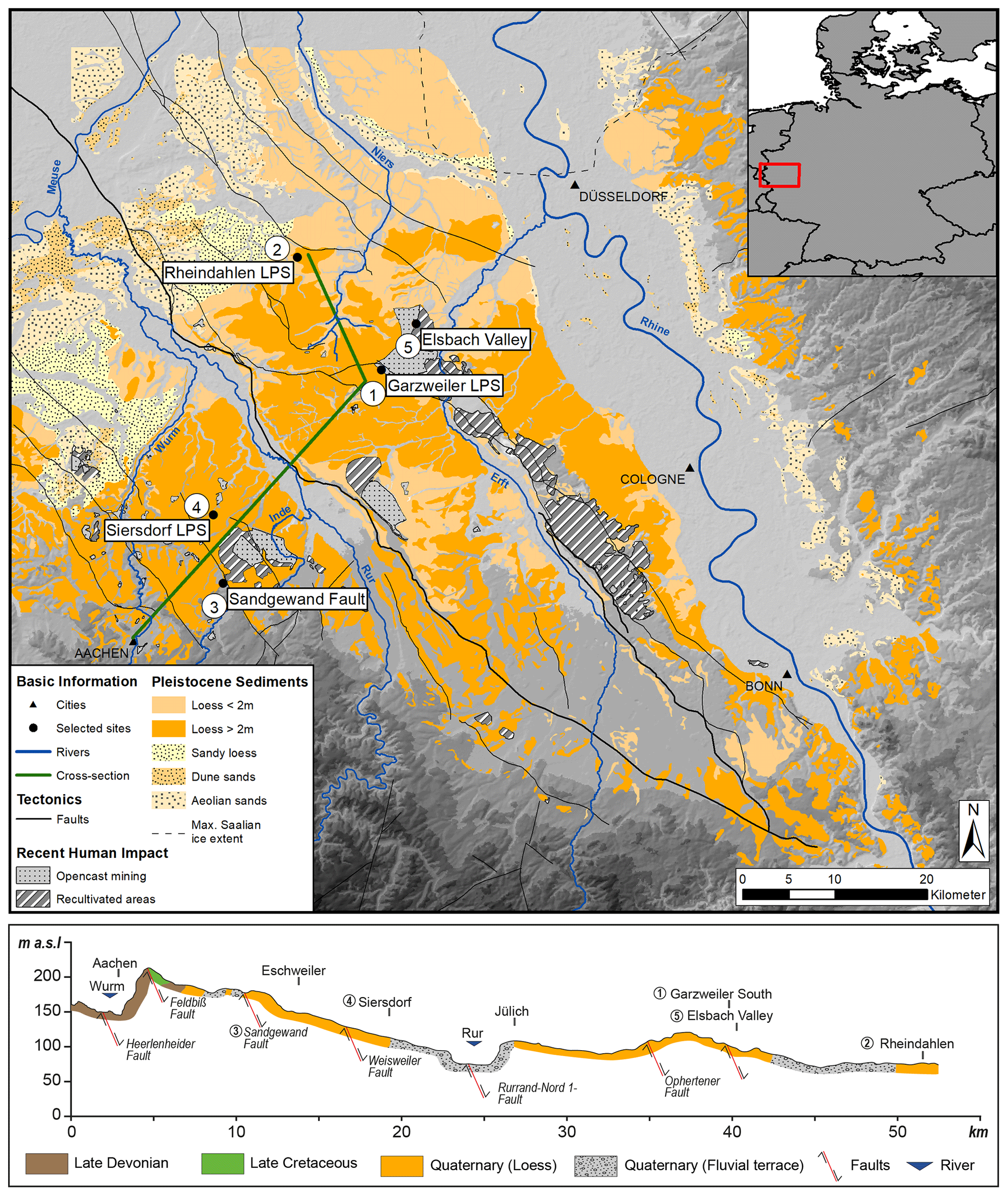
Figure 1Map with distribution of aeolian sediments in the Lower Rhine Embayment (modified after Lehmkuhl et al., 2016). The cross section shows the surface geology and fault lines. The five selected sites are examples for different geomorphological settings. Map and geological data based on the geological survey maps at 1:100 000 (Geological Survey of North Rhine-Westphalia, 2013) and the geological survey maps at 1:200 000 (Federal Institute for Geosciences and Natural Resources, 2002).
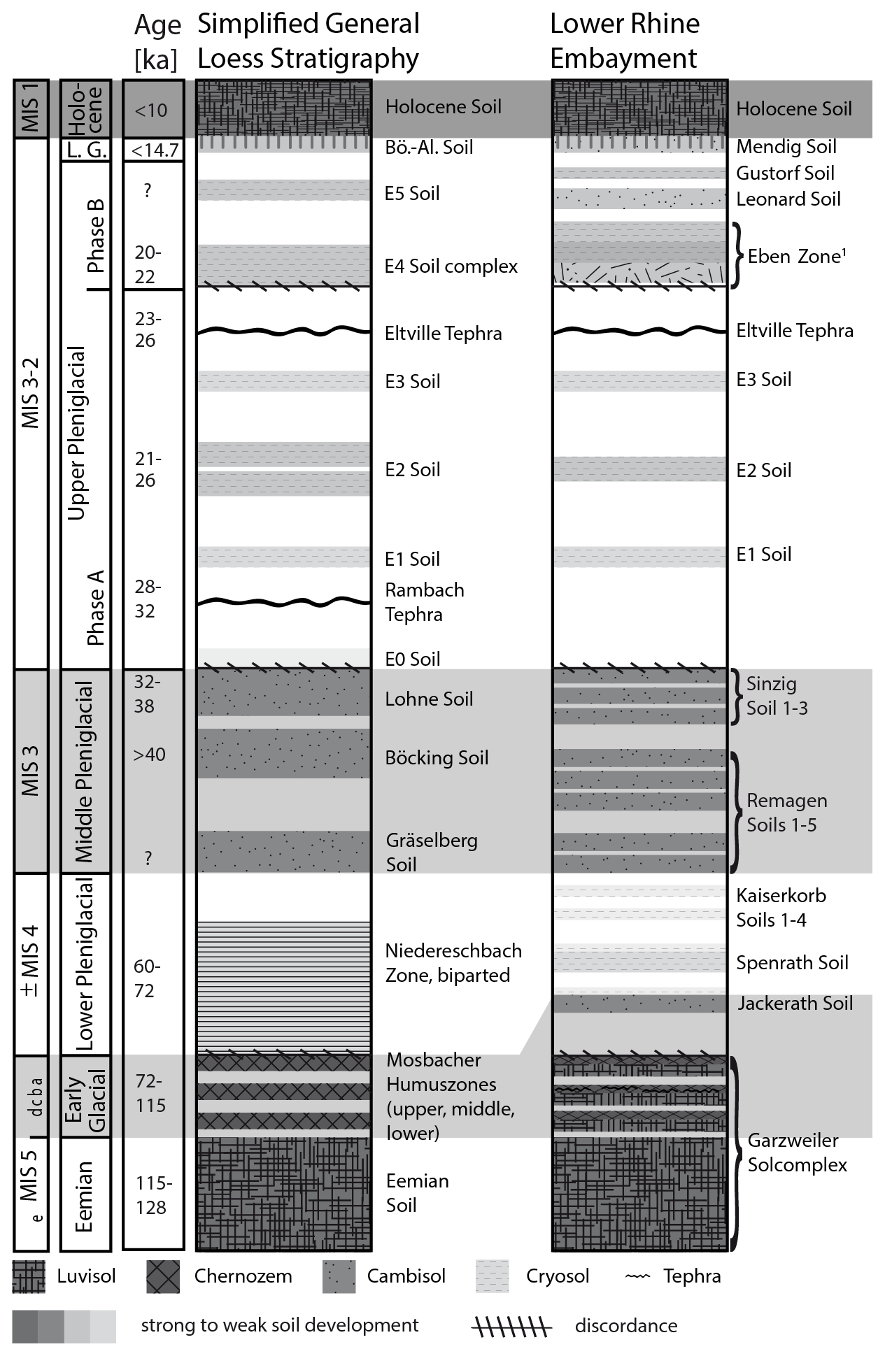
Figure 2Simplified western European loess stratigraphy and comparison with the local stratigraphy of the LRE (Lehmkuhl et al., 2016, modified). The Eben Zone contains the Kesselt Layer, Belmen and Elfgen soils (cf. Schirmer, 2016). The Loess stratigraphy is named according to the pedostratigraphic notation of Antoine et al. (2009, 2013). The Marine Isotopic Stages (MISs) are mentioned as an additional large-scale climatic orientation (without exact temporal correspondence for the LRE).
The Lower Rhine Embayment shows clear differences in the occurrence and properties of LPSs in relation to the (meso-)relief. Loess sequences in plateau-like positions, which are flat to undulating interfluve areas, tend to be shorter, shallower and more affected by erosion than sections in depressions, in paleochannels, on gentle inclined straight slopes and on slope toes. The latter are often covered by reworked sediments of older paleosols redeposited as heterogeneous, finely laminated colluvium (Lehmkuhl et al., 2016; Schirmer, 2016, and references therein). In order to demonstrate the different effects of the relocation and soil formation processes on the LPS as a function of the geomorphological setting, we selected five sites: these are Garzweiler, Rheindahlen, Sandgewand fault, Siersdorf and Elsbach Valley. Previously published stratigraphic data are re-evaluated and discussed in the context of the landscape dynamics of the LRE.
The long LPS exposed in the opencast lignite mine of Garzweiler (Fig. 3a) shows a typical Pleistocene stratigraphy of the LRE. Older deposits, dating back to the Middle Pleistocene, are usually decalcified and relatively dense. The younger, Late Pleistocene loess deposits show varying carbonate contents, mainly governed by weathering processes and leaching. In addition, fluvial erosion is displayed by gullies and small trough-shaped valleys. For a detailed analysis of the architecture and stratigraphy of the Garzweiler LPS, see Kels (2007).
The Rheindahlen LPS (Fig. 3b) is exposed in a former brickyard near the city of Mönchengladbach (Fig. 1). This sequence is a crucial archive for the LRE, as it additionally hosts some of the oldest stratified Middle Paleolithic artifacts in the LRE (Bosinski, 1966). The stratigraphy is condensed due to erosional processes. The plateau-like setting favored the preservation of Weichselian, Saalian and Elsterian loess sediments and interglacial and interstadial paleosols (Klostermann and Thissen, 1995).
Thin loess and periglacial cover beds were exposed at the Sandgewand fault (Fig. 3c) close to Eschweiler in the course of the construction of a pipeline. Here, the loess cover is very thin (less than 1 m) or in many cases absent. Pleniglacial silty sediments, including ice wedge pseudomorphs that cut through them, are adjacent in the upslope plateau setting. (Fig. 4a). Exposures along the slope of the Sandgewand fault (Fig. 4b) show alternating layers of shallow periglacial cover beds (debris layers) and weathered thin silty sediments in the following sequence from the base to the toe of the slope. The weathered debris of the Paleozoic basement of the exposure is covered by pebbles and gravels, possibly corresponding to the main terrace of the Early Pleistocene. There is a cover layer of solifluction debris (30 to 40 cm thick) with a hook-shaped form downslope from the Sandgewand fault. This downfaulted material is covered by thin silty sediments (30 to 10 cm) and a second periglacial debris layer (40 to 20 cm). Along the whole trench Holocene colluvial deposits and disturbed surfaces form the top of the sequence.
The Siersdorf LPS (Fig. 3d) shows the situation of a paleochannel incised into an old Pleistocene terrace (Knaak et al., 2021; Pötter et al., 2023). This channel was filled up during the Middle to early Upper Pleniglacial. After aeolian dust was trapped in a wet environment characterized by swampy conditions, loess and soil sediments were deposited by short-range fluvial relocation. The Upper Pleniglacial shows a rather typical sequence of marker horizons, such as the so-called Eben Zone (Fig. 2). Larger ice wedge pseudomorphs and frost crevasses extend from the Brabant loess into the upper part of the Hesbaye loess, indicating a cold and dry climate at the end of the last glacial cycle. The laminated Hesbaye loess contains also smaller ice wedge pseudomorphs.
The sequence exposed in the Elsbach Valley (Fig. 3e) provides a complex stratigraphy resulting from the superimposition of different Pleistocene and Holocene processes. This exposure was opened up and later completely removed by Garzweiler opencast mining. The trough-shaped valley head showed a sequence with several fluvial channels filled with aeolian and fluvial sediments. The loess deposit is dissected by numerous paleochannels that were filled with relocated Saalian sediments. These sediments are covered with small remnants of the Eemian soil on top. Based on a stratigraphic evaluation, it was eroded during the Lower Pleniglacial or Middle Pleniglacial. The completely missing Middle Pleniglacial reflects the “normal case” of the LRE. The Upper Pleniglacial is well preserved, and the Eben unconformity follows the paleochannel and eroded older sediments again in the middle part of the section (Lehmkuhl et al., 2016). During the Holocene the trough-shaped valley head was completely filled with more than 7 m of colluvial sediments, thereby reducing the relative relief and causing a flattening of the landscape. The processes were triggered and enhanced by climatic shifts but mainly by soil erosion and colluvation due to anthropogenic land use change and agriculture.
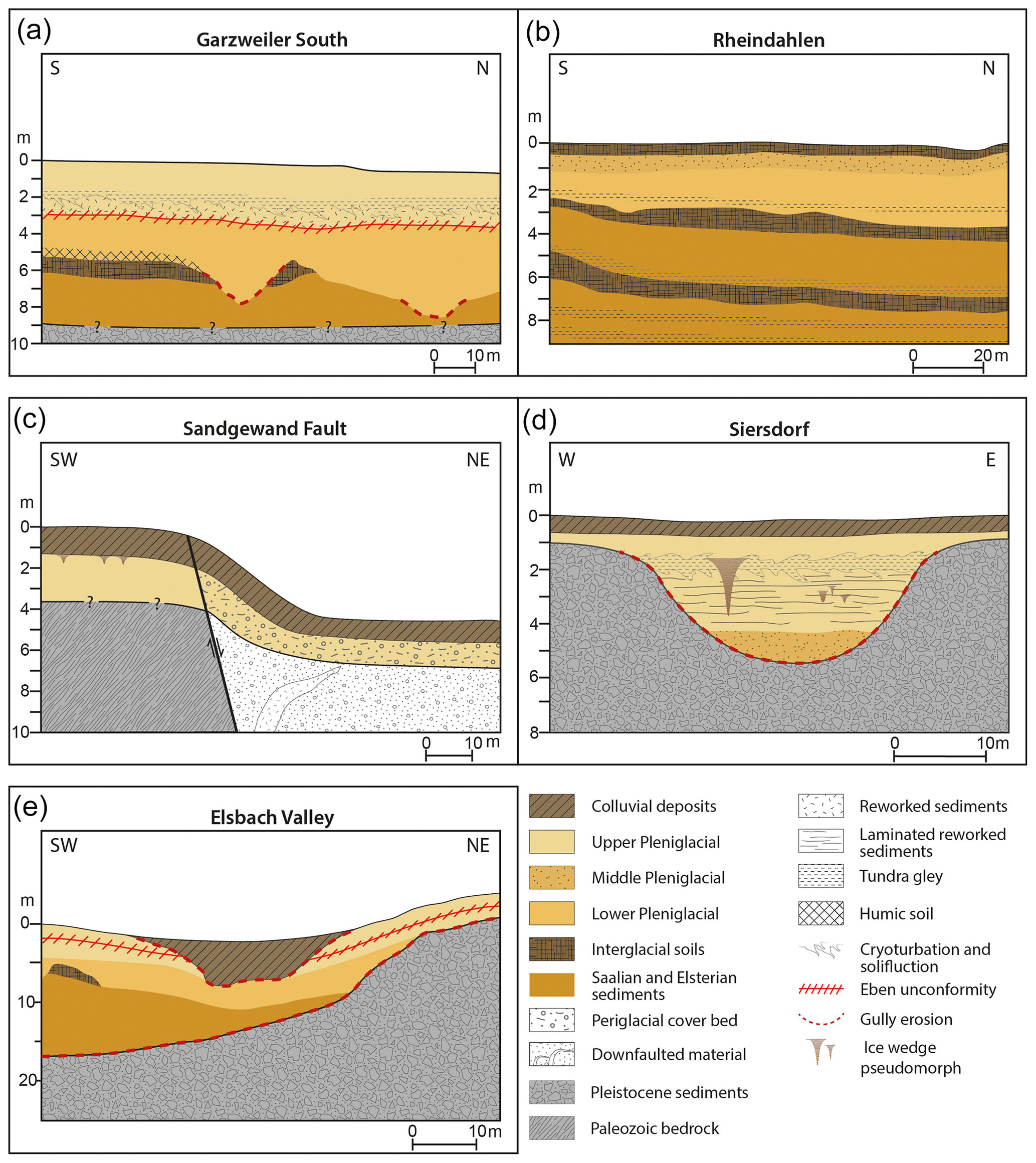
Figure 3Selected key sites. Further explanations are given in the text; for locations see Fig. 1.
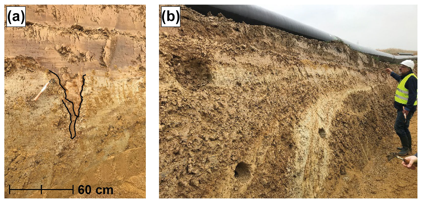
Figure 4Exposures in a trench close to the Sandgewand fault near Eschweiler (Figs. 1 and 3c) during pipeline construction. (a) Pleniglacial silty sediments including ice wedge pseudomorphs in the upslope plateau setting. (b) Slope position near the fault. A hook-shaped sequence of alternating layers of two shallow periglacial cover beds (debris layers) interbedded and topped by weathered thin silty sediments covers the weathered debris of the Paleozoic basement. In both images, Holocene colluvial deposits and disturbed surfaces form the top of the sequences (Photos: Frank Lehmkuhl, 2020).
Different landscape settings and related sediment sequences provide insights concerning the relation between typical geomorphological processes and the correlated sediment stratigraphy. The analysis of Pleistocene LPSs and Holocene colluvial and alluvial sediments enables the reconstruction of the paleoenvironmental evolution from the Middle Pleistocene onwards (Fig. 2).
4.1 Pleistocene settings, environments and processes
Loess landscapes are formed by a multitude of geomorphological and sedimentological processes. This so-called sedimentary history of loess is influenced not only by processes within the landscape itself, but also by processes in source regions for detrital material (Pötter, 2021). The most important sedimentological process in loess landscapes is dust accumulation (Pye, 1995, 1984), mostly on topographic barriers (Antoine et al., 2016; Leger, 1990; Lehmkuhl et al., 2016) or vegetation (Zech et al., 2012), so-called loessification (Sprafke and Obreht, 2016). However, post-depositional processes strongly shaped these landscapes during the Pleistocene and Holocene. These processes include
-
erosion and relocation due to fluvial processes (slope wash during the Pleistocene and slope wash and gully erosion in the Holocene)
-
permafrost-related processes including ice wedge pseudomorphs
-
solifluction and freezing–thawing processes including periglacial wash denudation
-
aeolian sedimentation and deflation in later times
-
soil formation during interglacials and interstadials.
In the following, we will evaluate the effect of these processes in the various geomorphological settings.
4.1.1 Geomorphological setting and Pleistocene processes
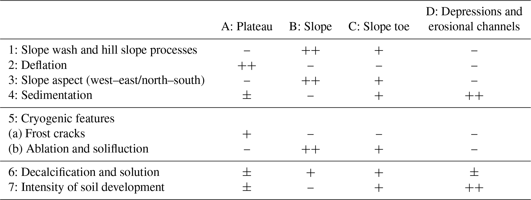
Lehmkuhl et al. (2016) defined four main geomorphological positions for LPSs in the LRE (Table 1): plateau-like areas, flat to undulating interfluve areas and flat-topped loess-covered fluvial terrace remnants, which are here named plateaus, slopes, slope toes, depressions and erosional channels. The most important factors affecting the characteristics of loess deposits are slope wash and hillslope processes, the slope aspect, dust accumulation and deflation, cryogenic processes, and solution and other processes of soil formation.
The geomorphologic setting has strongly influenced the processes in the Pleistocene. Table 1 summarizes the different processes and intensities of processes associated with the topographic settings. Loess, which is formed on a plateau-like position, is rarely eroded by slope wash due to the low gradients. However, deflation can play an important role in these positions, resulting in shorter, shallower and more condensed sequences. Deflation in plateau situations and interfluve areas often leads to erosional hiatuses. Additionally, these sequences are often affected by frost and desiccation cracks (see examples in Lehmkuhl, 2016). LPSs in slope positions are affected by intense erosion and relocation processes (Table 1). Slope wash during the Pleistocene was most likely related to nivation, i.e., snow accumulation and thawing. During large parts of the Pleistocene periglacial conditions in the LRE resulted in solifluction as a denudative slope process. Bedrock areas favored the formation of periglacial cover beds. Solifluction starts at slope gradients as low as 2∘ (see French, 2017, and references therein) and can give rise to marked unconformities in the LPS. Especially the LRE, as a humid loess landscape region (cf. Lehmkuhl et al., 2016, 2021), was prone to intense relocation processes on slopes such as solifluction. Therefore, depressions and slope toes are mainly composed of relocated loess instead of pure aeolian deposits. For example, the Eben unconformity and the following Kesselt Layer provide evidence for slope erosion and denudation resulting in a hiatus and for drier periods in ice wedge pseudomorphs (Fig. 5). Most studied loess sequences are, however, situated either on slope toes or in depressions and filled paleochannels. As dust on slope toes is often accumulated on the leeward topographic barrier of the valley (east-facing slope), the asymmetric valleys of the periglacial loess belt favored the accumulation of loess (Antoine et al., 2016; Lehmkuhl et al., 2021, 2016). The importance of topographical barriers and depressions in loess formation was highlighted by several authors (Antoine et al., 2016; Leger, 1990; Lehmkuhl et al., 2021, 2016; Mason et al., 1999; Muhs, 2013). The slope aspect also reveals that dust was mainly deposited on eastern (lee) sites. Very often asymmetric (periglacial) valleys strengthened this process. The formation of loess has been affected by soil processes and colluviation in depressions and at slope toes.
Table 1Processes in loess landscapes in relation to the relief. The impact of different processes according to the position of loess sections from weak (−), medium (±), strong (+) to very strong (). Modified according to Lehmkuhl et al. (2016).
4.1.2 Middle Pleistocene deposits and processes
Middle Pleistocene loess deposits are rarely found in the LRE. Most (pedo-)sedimentary features of pre-Saalian age, i.e., older than Marine Isotope Stage (MIS) 6, are only preserved in specific geomorphological situations. Type localities for pre-Saalian loess in the LRE are, e.g., the Rheindahlen and Erkelenz LPSs (Schirmer, 2002). In adjacent regions in southern Limburg in the Netherlands and Belgium, the Kesselt–Op de Schans and Hezerwater LPSs provide chronostratigraphic sequences reaching back up to MIS 12 (Meijs, 2002; Meijs et al., 2013; van Baelen, 2017; Vanmonfort et al., 1998). Although in special situations Middle Pleistocene deposits may account for up to 25 % of the sedimentary budget (Kels and Schirmer, 2011), the relatively poor preservation of Middle Pleistocene loess in the LRE is due to several factors. Firstly, the paleogeography of the European loess belt changed substantially throughout the Pleistocene. During the Elsterian glaciation, vast proglacial lakes in northern Central Europe reduced the size of important potential deflation areas. These areas could not serve as dust sources (Lehmkuhl et al., 2021). Secondly, the depositional milieu of aeolian sediments in the European loess belt shifted southwards due to the greater extent of the Middle Pleistocene continental ice sheets compared to the Late Pleistocene ones. During the Saalian glaciation, e.g., the ice extent reached the LRE, with margins near the city of Düsseldorf (Fig. 1, extent modified according to Ehlers et al., 2011). Aeolian cover sands and sand dunes were formed in the vicinity of the ice sheets, comparable to the Late Pleistocene European sand belt, and loess deposits developed to the south (southwest) (Kalińska-Nartiša et al., 2015; Lehmkuhl et al., 2016; Zeeberg, 1998). Thirdly, the Middle Pleistocene loess deposits of the LRE were strongly affected by erosion, reworking, relocation and re-deposition during later stages. The vastest extent of Pleistocene continental ice sheets occurred during the penultimate glacial (MIS 6; Ehlers et al., 2011). During the glacial advances, older loess deposits were reworked and eroded. In contrast, in the Late Pleistocene, the margin of the continental ice sheets was further north, and the LRE was under the influence of permafrost (Andrieux et al., 2016; Lehmkuhl et al., 2021; Vandenberghe et al., 2014), which contributed to a reworking of the loess deposits (see Sect. 4.1.3).
The Middle Pleistocene loess deposits of neighboring southern Limburg show characteristic features related to the paleogeography. According to van Baelen (2017) and Meijs et al. (2013), Kesselt–Op de Schans exhibits a local chronostratigraphic sequence which can be attributed to MIS 8 and 9. Due to the vicinity of the continental ice sheets, these deposits can be characterized as sandy loess. Loess deposits in the LRE associated with the Saalian glacial period are relatively homogenous when compared stratigraphically with Late Glacial loess (see Sect. 4.1.3). The deposits mainly consist of solifluidal and colluvial loess packages. The onset of Saalian loess formation took place after an extensive landscape reorganization with almost complete erosion of older loess deposits, associated with the so-called Wetterau discordance (Schirmer, 2002). The Saalian sequences in the LRE and adjacent regions generally show relatively high contents of fine sand, indicating a nearby source area, such as the glaciofluvial outwash plains of the Drenthe stadial ice sheets (Lehmkuhl et al., 2017).
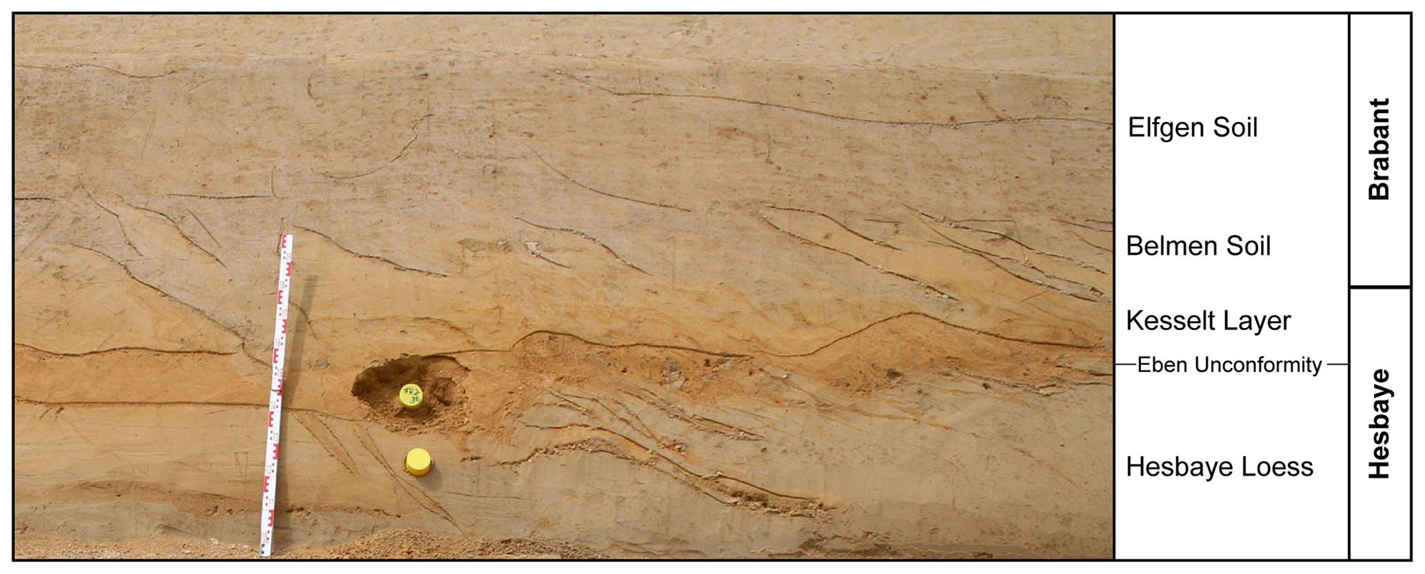
Figure 5The Eben Zone including the Kesselt Layer in the valley head of the Elsbach creek. The ice wedge pseudomorphs disturb the horizon of the underlying Eben unconformity. Photo: Frank Lehmkuhl.
The oldest loess sequences related to the penultimate Saalian glacial cycle in the LRE are found in the Garzweiler lignite mine (e.g., Kels, 2007) and in Rheindahlen. Additionally, Middle Paleolithic archeological findings were reported, for example, from the nearby region near Maastricht, the Netherlands; in Hezerwater at Veldwezelt (Vanmonfort et al., 1998); and in the brickyard quarry Kesselt–Op de Schans. Inden-Altdorf in the LRE revealed the first open-site habitation features with associated hearths and stone tools for the Middle Paleolithic in Central Europe (Pawlik and Thissen, 2017). These sites are ideally located as they provide access to fluvial gravel of the old Meuse River terraces, which contain a large number of flint pebbles as a high-quality raw material source of flint. For the Middle Paleolithic site of Inden-Altdorf unfortunately the geomorphological setting, sedimentation and the dating methods of the site are not described in detail. Pawlik and Thissen (2017) stated that this site dates to an earlier phase of MIS 5, between ca. 120–100 ka and the time of early Neanderthals in Europe.
4.1.3 Late Pleistocene deposits and processes
The Late Pleistocene and especially the last glacial period are imprinted in the LRE as a highly complex pedostratigraphic succession (see Fig. 2; Antoine et al., 2016; Lehmkuhl et al., 2021, 2016). This complex stratigraphy is, e.g., due to large erosional gaps which were formed during climatic transitions. Therefore, complete Late Pleistocene loess archives are rare (Lehmkuhl et al., 2016; Zens et al., 2018). After the Eemian interglacial, Chernozem-like humic soils were formed under steppe-like environmental conditions. This was followed by a transition to colder and more continental conditions, which are reflected in the respective loess stratigraphy (e.g., Haesaerts et al., 2016; Schirmer, 2016; Semmel, 1998). The first phases of the last glacial cycle are characterized by redeposited finely laminated sediments, while the loess packages contain several thin and weakly developed tundra gleys and humic soils (Zens et al., 2018). The most recent loess layer in this subdomain contains two sedimentary facies: the niveo-aeolian (cold-humid) and the homogenous loess (cold-arid). They were termed Hesbaye and Brabant loess in Belgium and the Lower Rhine Embayment (e.g., Haesaerts et al., 2016; Schirmer, 2016) and can be also observed in northern France (Antoine et al., 2016).
As mentioned above, the LRE was affected by a variety of geomorphological processes (Table 1). These processes were mainly governed by the prevalence of periglacial conditions combined with the more oceanic climate of the LRE. Compared to loess domains further east with a more continental climate, permafrost features such as ice wedge pseudomorphs prevail (Jary, 2009).
In the lowlands of the LRE, between the Rur and Rhine rivers, there are large loess plateaus (flat to undulating interfluve areas). The loess often covers Pleistocene river terraces, as in the case of the Rheindahlen (Bosinski, 1966) or parts of the Garzweiler LPS (Kels, 2007). Slope processes such as solifluction are subordinate in plateau environments (Table 1). However, LPSs in such settings can be affected by other processes triggered or enhanced by periglacial conditions. Frost crack formation or cryoturbation are important post-depositional alteration processes in plateau environments, influencing pedofeatures formed in situ such as clay cutanes (Martin Kehl, personal communication, December 2022).
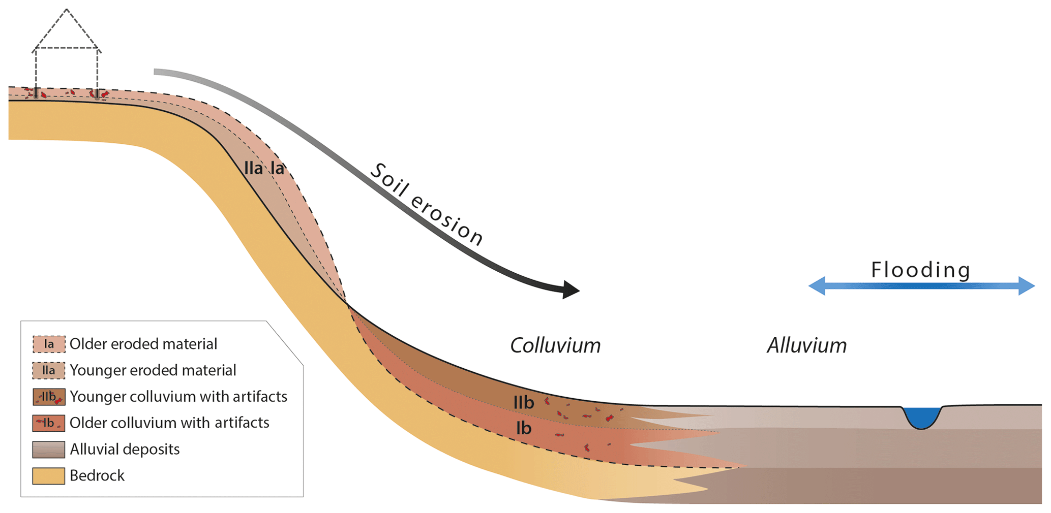
Figure 6Simplified sketch of the acceleration of soil erosion and the development of colluvium due to the onset of agriculture since the Neolithic Revolution and Metal Ages. This soil erosion also enhanced floodplain sediments (alluvium). Archeological finds are relocated and buried under colluvial sediments. Redrawn and modified according to Gerlach (2006).
Solifluction was one of the dominant processes in slope positions (Table 1). This is evident in parts of the long section of the Garzweiler LPS or the Elsbach Valley with a gradient of more than 2∘. In addition, the location at the Sandgewand fault exposure near Eschweiler provides evidence for strong downslope movements of thin layers of loess derivates and debris of periglacial cover beds, indicating wet and cold conditions (Figs. 3, 4). At the slope position the sedimentary sequences were reworked twice by solifluction, probably during the Pleniglacial and, again, during the Younger Dryas.
Depressions and (dry) valleys are specific settings which act as sediment sinks for aeolian dust and reworked sediments. This is indicated in the Siersdorf LPS. In this LPS the Middle to Upper Pleniglacial sequence developed in an incised channel of a Middle Pleistocene river terrace (Pötter et al., 2023). Depressions and paleochannels influence not only sedimentary processes, but also (micro-)hydroclimatic conditions. In Siersdorf, the channel setting favored the development of wet, swampy conditions, with periodic semi-terrestrial conditions during the late Middle Pleniglacial. After this episode, however, the channel acted as a sink for relocated soil sediments, which were deposited in the early Upper Pleniglacial. Subsequently, aeolian accumulation resumed producing a typical Upper Pleniglacial succession, including the Eben Zone and unaltered, high-glacial loess (Pötter et al., 2023).
4.2 Holocene morphodynamics and human interferences
Since the Late Pleistocene (Bolling–Allerød oscillation), rapid warming has resulted in a denser vegetation cover and in soil development. This warm period was interrupted by the cooling event of the Younger Dryas. Due to the dense vegetation cover since the beginning of the Holocene, the rates of geomorphologic processes on the land surface in Central Europe were reduced and the morphodynamic activity was weaker as compared to the Pleistocene. Natural Holocene processes are characterized by soil development and in generally moderate fluvial erosion and accumulation, especially in the floodplains.
Human societies have interfered with the landscapes and soils by different agricultural practices and land use changes, especially since the onset of agriculture in the Neolithic period. The effects of land use on highly erodible loess were often associated with severe soil erosion including the development of gullies and colluvial accumulations. At the same time soil erosion resulted in an increased sediment supply to the rivers, thereby enhancing the accumulation of floodplain and alluvial deposits (Fig. 6). These deposits often serve as indications for climate or land use change. As a consequence of the increasing agricultural land use since the Neolithic Revolution, soil erosion was associated with the development of colluvial deposits at foot slopes. In particular colluviation was enhanced during the Metal Ages and the Middle Ages. An additional consequence was that archeological remains and finds were destroyed, relocated and buried under colluvial sediments.
In the Lower Rhine Embayment, as in other parts of Central Europe, there are several main periods of colluvial deposition or colluviation. Increased colluviation occurred during the Metal Ages, Roman times, medieval times and modern times (see Table 2). Four main periods associated with alluvial and floodplain deposition can be distinguished (see Table 2). The depositional periods of colluvial sedimentation can be distinguished using an interdisciplinary approach including granulometric, geochemical and archeological methods (Protze, 2014).
Especially during the Metal Ages and High Middle Ages erosion is clearly detectable. In the woodlands the production of charcoal and firewood, as well as grazing activities, led to a strong deforestation. In addition, the development of mining and related industries in the 15th to 16th centuries, as well as the increase in these activities in the 19th century, resulted in a high contamination of floodplain deposits. Different periods of minor soil erosion can be distinguished since medieval times. Socioeconomic effects and the increase in grassland resulted in a reduction in soil erosion (Nilson, 2006; Schmidt-Wygasch, 2011).
The floodplain or overbank sediments, consisting mainly of silty material, were deposited on the valley floors near rivers and alluvial systems. Below these silty deposits, coarser Pleistocene deposits are composed mainly of gravels interspersed with sandy layers and sandy lenses. As silty accumulations are less resistant to erosion they are often removed during floods. Deposits in abandoned channels, gullies or depressions are usually better preserved than plain accumulations. Particularly overbank deposits are often associated with human activity and can preserve important paleogeographical information (Kalicki, 2000).
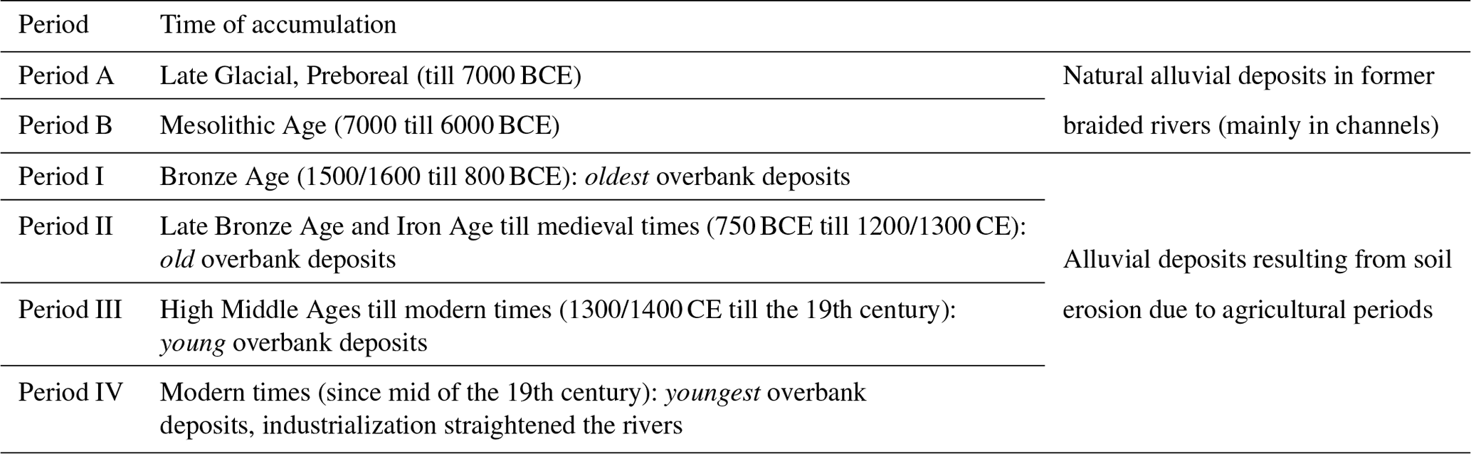
Schmidt-Wygasch (2011) demonstrated for the lower reaches of the Inde River in the LRE that the first overbank deposits above the Pleistocene gravel layer of the lower terrace were accumulated in the Late Glacial and the Preboreal periods (A and B in Table 2). These loamy deposits resulted from land cover change at the transition from the Pleistocene to Holocene, which was associated with a change from braided river systems to meandering rivers incising into more cohesive material. There apparent lack of floodplain sedimentation in the early Holocene and Neolithic Age (Atlantic period) was associated with widespread soil development. The lack of floodplain sedimentation and soil formation is an indication of low soil erosion and therefore low sedimentation.
The first period characterized by enhanced soil erosion started in the Bronze Age (Subboreal) with the onset of more intensive land use. The clearance and agriculture supported the sediment transport to the rivers and floodplains and the accumulation of overbank deposits. Beginning with this time Schmidt-Wygasch (2011) distinguished four periods of widespread accumulations of overbank or floodplain deposits (I–IV in Table 1): (I) the beginning of agriculture since Neolithic times and enhanced land use during the Metal Ages, (II) the enhanced impact of agriculture and soil erosion in Bronze Age times, (III) the period of maximum soil erosion in the medieval times including the first acceleration in the beginning of the 19th century, and (IV) modern times since the middle of the 19th century including the Great Acceleration after World War II with modern agriculture and channelized rivers and creeks. All periods of enhanced soil erosion are human induced and resulted from land cover change by agriculture (anthropogenic origin). The maximum accumulation of floodplain deposits occurred in periods II and III. Figure 7 shows the accumulation of floodplain sediments in the lower reaches of the Inde River above a layer with Roman roof tiles (tegula) above abandoned river channels. This indicates more than 2 m of floodplain aggradation during the last 2000 years of such a small river in loess landscapes. Since the end of the 19th century the rivers were straightened and river banks were increasingly protected by embankments (Wolf et al., 2021). These changes were associated with a more concentrated and enhanced discharge, which in turn, resulted in reduced accumulation rates on the floodplains. Concerning the human interferences in river systems since the end of the 19th century, Wolf et al. (2021) were able to distinguish several periods of land use change and river (water) management.
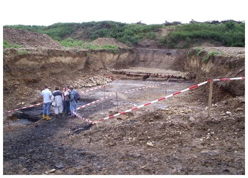
Figure 7Exposure in the fore field of the lignite mining in the floodplain deposits of the (old) Inde River. Roman archeological layer with roof tiles (tegula) was buried by more than 2 m of overbank deposits. Beyond the people two small river channels are visible. Within the first small step wooden posts as fortification against lateral erosion were found. In the background the loess-covered middle terrace with a Roman villa rustica on top is situated. Photo: Frank Lehmkuhl (2008).
Table 2Time of accumulation of the overbank deposits. Adapted and modified from Schmidt-Wygasch (2011).
Loess is one of the main terrestrial archives of Pleistocene landscapes and environments and therefore has an important connection to the preservation and interpretation of Paleolithic sites (Chu and Nett, 2021). These authors summarized the current trends and future directions in Pleistocene geoarcheology of European loess. They stated that loess records are unique insofar as they can address broad-scale spatiotemporal changes, but they can also provide windows into brief moments in time.
The low-energy deposition of Late Pleistocene loess-forming dust is known to finely preserve archeological sites with minimal spatial redistribution that can often be refitted to an impressive degree (Roebroeks et al., 1997; Vallin et al., 2001) and are even occasionally suitable for use-wear and residue analyses (Pawlik and Thissen, 2017; Sano, 2012; Wilczyński et al., 2020). Loess records are also excellent repositories of faunal prey, fire features, pits, habitation structures and early hominid burials that provide singular insights into local hominid behavioral patterns (see Chu and Nett, 2021, and references therein). The thickness and temporal resolution of the loess cover vary depending on the relief position. In the LRE this is related to the distribution of different tectonic blocks, the Pleistocene terraces and the distribution of bedrock. The sequences are often incomplete in their temporal resolution due to erosional discordances.
Fault scarps and terrace edges have been smoothed by geomorphic processes, such as solifluction and slope wash. As shown by Lehmkuhl et al. (2015) the depth of the Eemian Rocourt soil complex varies between 1 and 5 m below the surface.
Toward the north and west the aeolian deposits coarsen to sandy loess and sand. The coarsening is a function of the northern loess margin and the distribution of Neogene and Paleogene sands and the proximity of the formerly braided Meuse River system in the west which acted as additional local sand sources. During the maximum extent of the ice sheets in the penultimate glacial cycle (see the extent of the Saalian ice in Fig. 1), the ice margin extended much further south and consequently the loess facies is much coarser. All of the older deposits may have been subjected to reworking and repositioning during later periods. Middle Pleistocene loess can be found in the LRE just in a few places, especially in depressions and on higher terraces.
The complex response of the geomorphic process system continued through the Holocene and was amplified by human interferences, resulting in soil erosion and in the deposition of colluvial and alluvial sequences. These processes destroyed upslope archeological remains but preserved several sequences with valuable information on human occupation and land use change at the slope toe and in depressions.
The study of the Pleistocene and Holocene geomorphologic dynamics in the different relief settings provides for geoscientists and archeologists an analytical tool for reconstructing the settlement, the environment and the landscape evolution. The analysis of the different intensities of erosion, relocation, redeposition and transformation processes with respect to the different temporal and spatial scales remains a challenging task in loess research. In addition, loess deposits have undergone post-depositional alterations such as weathering, bioturbation and pedogenesis that obscure anthropogenic evidence. Understanding the relationship between relief position and geomorphic processes enables a more comprehensive analysis of the complex stratigraphy of the LPSs and of sedimentary environments which are related to the (paleo-)relief. Understanding these relationships will allow the consideration of environmental differences in relation to relief position in archeological studies. Therefore, loess research requires interdisciplinary research, especially between archeologists and geomorphologists.
Loess is a valuable archive for archeological findings and provides evidence of the paleoenvironmental setting of human settlements. In addition, the timing of human occupation and the paleoclimate evolution can be disentangled through the analysis of LPSs. Marker layers and different dating techniques help to constrain the timing. Landscapes in the northern European loess belt and especially in humid periglacial environments not only have been shaped by the formation of widespread loess deposits during the Middle and Late Pleistocene but have also been subjected to reworking processes by periglacial and fluvial processes. In addition, active tectonics since the Pleistocene have influenced the thickness and preservation of loess in the LRE. During periods of less intensive land use in the early Holocene, soils developed on more or less stable land surfaces. As loess landscapes provide very fertile soils, they are among the first regions to undergo Neolithic agriculture. However, with the onset of agriculture and changes in land use, soil erosion caused enormous sediment relocations and relief changes. Colluvial and alluvial sediments resulting from soil erosion provide an additional archive of landscape evolution. They contain archeological findings from the Neolithic period onwards. All these different geomorphological processes have contributed to smoothing of the more pronounced paleo-relief of the LRE. The flat landscape we find today is the result of the natural and human-enhanced geomorphic processes that must be considered in loess and archeological research.
All data are provided in the tables and figures of this paper and are available upon request to the corresponding author.
FL: conceptualization, supervision, writing and design of the original draft, funding acquisition. PS: validation, writing original draft, visualization. WR: validation, writing original draft, data curation. SP: validation, writing original draft, data curation.
All authors contributed to the discussion and interpretation of the results and reviewed and edited the manuscript.
The contact author has declared that none of the authors has any competing interests.
Publisher’s note: Copernicus Publications remains neutral with regard to jurisdictional claims in published maps and institutional affiliations.
We would like to thank Max Formen and Viktor Schaubert for their help with the figures. Discussions with numerous colleagues from loess research, geology and archeology, especially during the joint research in the frame of the CRC 806 “Our Way to Europe” and with Renate Gerlach and Jürgen Richter, are acknowledged.
This open-access publication was funded by the RWTH Aachen University.
This paper was edited by Christopher Lüthgens and reviewed by Ludwig Zoeller and one anonymous referee.
Ahorner, L.: Untersuchungen zur quartären Bruchtektonik der Niederrheinischen Bucht, E&G Quaternary Sci. J., 13, 24–105, https://doi.org/10.3285/eg.13.1.04, 1962.
Andrieux, E., Bertran, P., and Saito, K.: Spatial analysis of the French Pleistocene permafrost by a GIS database: French Pleistocene permafrost database, Permafrost Periglac., 27, 17–30, https://doi.org/10.1002/ppp.1856, 2016.
Antoine, P., Rousseau, D.-D., Moine, O., Kunesch, S., Hatté, C., Lang, A., Tissoux, H., and Zöller, L.: Rapid and cyclic aeolian deposition during the Last Glacial in European loess: a high-resolution record from Nussloch, Germany, Quaternary Sci. Rev., 28, 2955–2973, https://doi.org/10.1016/j.quascirev.2009.08.001, 2009.
Antoine, P., Rousseau, D.-D., Degeai, J.-P., Moine, O., Lagroix, F., Kreutzer, S., Fuchs, M., Hatté, C., Gauthier, C., Svoboda, J., and Lisá, L.: High-resolution record of the environmental response to climatic variations during the Last Interglacial–Glacial cycle in Central Europe: the loess-palaeosol sequence of Dolní Věstonice (Czech Republic), Quaternary Sci. Rev., 67, 17–38, https://doi.org/10.1016/j.quascirev.2013.01.014, 2013.
Antoine, P., Coutard, S., Guerin, G., Deschodt, L., Goval, E., Locht, J.-L., and Paris, C.: Upper Pleistocene loess-palaeosol records from Northern France in the European context: Environmental background and dating of the Middle Palaeolithic, Quaternary Int., 411, 4–24, https://doi.org/10.1016/j.quaint.2015.11.036, 2016.
Boemke, B., Einwögerer, T., Händel, M., and Lehmkuhl, F.: Upper Palaeolithic site probability in Lower Austria – a geoarchaeological multi-factor approach, J. Maps, 1–9, https://doi.org/10.1080/17445647.2021.2009926, 2022.
Boenigk, W. and Frechen, M.: The Pliocene and Quaternary fluvial archives of the Rhine system, Quaternary Sci. Rev., 25, 550–574, https://doi.org/10.1016/j.quascirev.2005.01.018, 2006.
Bosinski, G.: Der paläolithische Fundplatz Rheindahlen, Ziegelei Dreesen-Westwand, Bonner Jahrbücher, 318–343 Seiten, https://doi.org/10.11588/BJB.1965.0.73843, 1966.
Chu, W. and Nett, J. J.: The past in dust: current trends and future directions in Pleistocene geoarcheology of European loess, J. Quaternary Sci., 36, 1279–1292, https://doi.org/10.1002/jqs.3388, 2021.
Chu, W., Pötter, S., Doboş, A., Albert, T., Klasen, N., Ciornei, A., Bösken, J. J., and Schulte, P.: Geoarchaeology and geochronology of the Upper Palaeolithic site of Temere?ti Dealu Vinii, Banat, Romania: Site formation processes and human activity of an open-air locality, Quartär, 66, 111–134, https://doi.org/10.7485/QU66_5, 2019.
Ehlers, J., Gibbard, P. L., and Hughes, P. D.: Quaternary Glaciations – Extent and Chronology, Elsevier, Amsterdam, 1126 pp., 77–101, 2011.
Einwögerer, T., Friesinger, H., Händel, M., Neugebauer-Maresch, C., Simon, U., and Teschler-Nicola, M.: Upper Palaeolithic infant burials, Nature, 444, 285–285, https://doi.org/10.1038/444285a, 2006.
Federal Institute for Geosciences and Natural Resources © 2002. General Geological Map of Germany 1:200,000 (GUEK200) – CC 5502 Cologne. Hannover.
Fenn, K., Durcan, J. A., Thomas, D. S. G., Millar, I. L., and Marković, S. B.: Re-analysis of late Quaternary dust mass accumulation rates in Serbia using new luminescence chronology for loess–palaeosol sequence at Surduk, Borea, 49, 634–652, https://doi.org/10.1111/bor.12445, 2020.
Fischer, P., Hambach, U., Klasen, N., Schulte, P., Zeeden, C., Steininger, F., Lehmkuhl, F., Gerlach, R., and Radtke, U.: Landscape instability at the end of MIS 3 in western Central Europe: evidence from a multi proxy study on a Loess-Palaeosol-Sequence from the eastern Lower Rhine Embayment, Germany, Quaternary Int., 502, Part A, 119–136, https://doi.org/10.1016/j.quaint.2017.09.008, 2017.
Fischer, P., Hambach, U., Klasen, N., Schulte, P., Zeeden, C., Steininger, F., Lehmkuhl, F., Gerlach, R., and Radtke, U.: Landscape instability at the end of MIS 3 in western Central Europe: evidence from a multi proxy study on a Loess-Palaeosol-Sequence from the eastern Lower Rhine Embayment, Germany, Quaternary Int., 502, 119–136, https://doi.org/10.1016/j.quaint.2017.09.008, 2019.
Fischer, P., Jöris, O., Fitzsimmons, K. E., Vinnepand, M., Prud'homme, C., Schulte, P., Hatté, C., Hambach, U., Lindauer, S., Zeeden, C., Peric, Z., Lehmkuhl, F., Wunderlich, T., Wilken, D., Schirmer, W., and Vött, A.: Millennial-scale terrestrial ecosystem responses to Upper Pleistocene climatic changes: 4D-reconstruction of the Schwalbenberg Loess-Palaeosol-Sequence (Middle Rhine Valley, Germany), CATENA, 196, 104913, https://doi.org/10.1016/j.catena.2020.104913, 2021.
Fitzsimmons, K. E., Doboş, A., Probst, M., and Iovita, R.: Thinking Outside the Box at Open-Air Archeological Contexts: Examples From Loess Landscapes in Southeast Romania, Front. Earth Sci., 8, 561207, https://doi.org/10.3389/feart.2020.561207, 2020.
Formicola, V., Pontrandolfi, A., and Svoboda, J.: The Upper Paleolithic triple burial of Dolni Vestonice: Pathology and funerary behavior, Am. J. Phys. Anthropol., 115, 372–379, https://doi.org/10.1002/ajpa.1093, 2001.
French, H. M.: The periglacial environment, Fourth Edn., Wiley, Blackwell, Hoboken, NJ, 1 pp., https://doi.org/10.1002/9781118684931, 2017.
Geilenbrügge, U.: Ausgrabungen und Forschungen zu den Metallzeiten im rheinischen Braunkohlenrevier, in: Materialien zur Bodendenkmalpflege, Braunkohlenarchäologie im Rheinland, vol. 21, edited by: Kunow, J., 53–58, 2010.
Gerlach, R.: Holozän: Die Umgestaltung der Landschaft durch den Menschen seit dem Neolithikum, in: Urgeschichte im Rheinland, edited by: Kunow, J. and Wegner, H., Köln, 87–98, 190 pp. 2006.
Gerz, J.: Prähistorische Mensch-Umwelt-Interaktionen im Spiegel von Kolluvien und Befundböden in zwei Löss-Altsiedellandschaften mit unterschiedlicher Boden- und Kulturgeschichte (Schwarzerderegion bei Halle/Saale und Parabraunerderegion Niederrheinische Bucht), Köln, https://kups.ub.uni-koeln.de/7529/ (last access: August 2023), 2017.
Haesaerts, P., Damblon, F., Gerasimenko, N., Spagna, P., and Pirson, S.: The Late Pleistocene loess-palaeosol sequence of Middle Belgium, Quaternary Int., 411, 25–43, https://doi.org/10.1016/j.quaint.2016.02.012, 2016.
Jary, Z.: Periglacial markers within the Late Pleistocene loess–palaeosol sequences in Poland and Western Ukraine, Quaternary Int., 198, 124–135, https://doi.org/10.1016/j.quaint.2008.01.008, 2009.
Kalicki, T.: Grain size of the overbank deposits as carriers of paleogeographical information, Quaternary Int., 72, 107–114, https://doi.org/10.1016/S1040-6182(00)00026-4, 2000.
Kalińska-Nartiša, E., Thiel, C., Nartišs, M., Buylaert, J.-P., and Murray, A. S.: Age and sedimentary record of inland eolian sediments in Lithuania, NE European Sand Belt, Quaternary Res., 84, 82–95, https://doi.org/10.1016/j.yqres.2015.04.001, 2015.
Kels, H.: Bau und Bilanzierung der Lössdecke am westlichen Niederrhein, https://docserv.uni-duesseldorf.de/servlets/DocumentServlet?id=3628 (last access: August 2023), 2007.
Kels, H. and Schirmer, W.: Relation of loess units and prehistoric ind density in the Garzweiler open-cast mine, Lower Rhine, E&G Quaternary Sci. J., 59, 59–65, https://doi.org/10.3285/eg.59.1-2.05, 2011.
Klostermann, J.: Das Quartär der Niederrheinischen Bucht, Geologisches Landesamt Nordrhein-Westfalen, Krefeld, 1–200, 1992.
Klostermann, J. and Thissen, J.: Die stratigraphische Stellung des Lößprofils von Mönchengladbach-Rheindahlen (Niederrhein), E&G Quaternary Sci. J., 45, 42–58, https://doi.org/10.3285/eg.45.1.05, 1995.
Knaak, M., Becker, S., Steffens, W., Mustereit, B., Hartkopf-Fröder, C., Prinz, L., Stichling, S., Schulte, P., and Lehmkuhl, F.: Boden des Jahres 2021 – ein Lössprofil auf der Aldenhovener Lössplatte, in: Archäologie im Rheinland 2020, Nünnerich-Asmus, Oppenheim, ISBN 978-3-96176-162-3, 2021.
Leger, M.: Loess landforms, Quaternary Int., 7–8, 53–61, https://doi.org/10.1016/1040-6182(90)90038-6, 1990.
Lehmkuhl, F.: Modern and past periglacial features in Central Asia and their implication for paleoclimate reconstructions, Prog. Phys. Geog.: Earth and Environment, 40, 369–391, https://doi.org/10.1177/0309133315615778, 2016.
Lehmkuhl, F., Wirtz, S., Falk, D., and Kels, H.: Geowissenschaftliche Untersuchungen zur Landschaftsentwicklung im Tagebau Garzweiler – LANU-Projekt 2012–2014, in: Archäologie im Rheinland 2014, edited by: Kunow, J. and Trier, M., Theiss Verlag, Stuttgart, 64–66, ISBN 978-3-8062-3214-1, 2015.
Lehmkuhl, F., Zens, J., Krauß, L., Schulte, P., and Kels, H.: Loess-paleosol sequences at the northern European loess belt in Germany: Distribution, geomorphology and stratigraphy, Quaternary Sci. Rev., 153, 11–30, https://doi.org/10.1016/j.quascirev.2016.10.008, 2016.
Lehmkuhl, F., Schulte, P., and Zens, J.: Sedimentological investigation of the stratigraphic sequence., in: The Lower to Middle Palaeolithic Transition in Northwestern Europe: Evidence from Kesselt-Op de Schans, Leuven University Press, 70–76, ISBN 9789462700987, 2017.
Lehmkuhl, F., Pötter, S., Pauligk, A., and Bösken, J.: Loess and other Quaternary sediments in Germany, J. Maps, 14, 330–340, https://doi.org/10.1080/17445647.2018.1473817, 2018.
Lehmkuhl, F., Nett, J. J., Pötter, S., Schulte, P., Sprafke, T., Jary, Z., Antoine, P., Wacha, L., Wolf, D., Zerboni, A., Hošek, J., Marković, S. B., Obreht, I., Sümegi, P., Veres, D., Zeeden, C., Boemke, B., Schaubert, V., Viehweger, J., and Hambach, U.: Loess landscapes of Europe – Mapping, geomorphology, and zonal differentiation, Earth-Sci. Rev., 215, 103496, https://doi.org/10.1016/j.earscirev.2020.103496, 2021.
Mason, J. A., Nater, E. A., Zanner, C. W., and Bell, J. C.: A new model of topographic effects on the distribution of loess, Geomorphology, 28, 223–236, https://doi.org/10.1016/S0169-555X(98)00112-3, 1999.
Meijs, E. P. M.: Loess stratigraphy in Dutch and Belgian Limburg, E&G Quaternary Sci. J., 51, 115–131, https://doi.org/10.3285/eg.51.1.08, 2002.
Meijs, E. P. M., van Peer, P., and de Warrimont, J. P. L. M. N.: Geomorphologic context and proposed chronostratigraphic position of Lower Palaeolithic artefacts from the Op de Schans pit near Kesselt (Belgium) to the west of Maastricht, Neth. J. Geosci., 91, 137–157, https://doi.org/10.1017/S0016774600001554, 2013.
Meurers-Balke, J., Kalis, A. J., Gerlach, R., and Jürgens, A.: Landschafts-und Siedlungsgeschichte des Rheinlandes, in: Knörzer K, editor. PflanzenSpuren. Archäobotanik im Rheinland: Agrarlandschaft und Nutzpflanzen im Wandel der Zeiten. Köln, Bonn: Rheinland-Verlag, Kommission bei R. Habelt, 11–66, 1999.
Muhs, D. R.: 11.9 Loess and its Geomorphic, Stratigraphic, and Paleoclimatic Significance in the Quaternary, in: Treatise on Geomorphology, Elsevier, 149–183, https://doi.org/10.1016/B978-0-12-374739-6.00302-X, 2013.
Nigst, P. R., Haesaerts, P., Damblon, F., Frank-Fellner, C., Mallol, C., Viola, B., Götzinger, M., Niven, L., Trnka, G., and Hublin, J.-J.: Early modern human settlement of Europe north of the Alps occurred 43,500 years ago in a cold steppe-type environment, P. Natl. Acad. Sci. USA, 111, 14394–14399, https://doi.org/10.1073/pnas.1412201111, 2014.
Nilson, E.: Räumlich-strukturelle und zeitlich-dynamische Aspekte des Landnutzungswandels im Dreiländereck Belgien-Niederlande-Deutschland: eine Analyse mittels eines multitemporalen, multifaktoriellen und grenzübergreifenden Geographischen Informationssystems, Publikationsserver der RWTH Aachen University, http://darwin.bth.rwth-aachen.de/opus3/volltexte/2006/1612/ (last access: August 2023), 2006.
Obreht, I., Zeeden, C., Schulte, P., Hambach, U., Eckmeier, E., Timar-Gabor, A., and Lehmkuhl, F.: Aeolian dynamics at the Orlovat loess–paleosol sequence, northern Serbia, based on detailed textural and geochemical evidence, Aeolian Res., 18, 69–81, https://doi.org/10.1016/j.aeolia.2015.06.004, 2015.
Obreht, I., Hambach, U., Veres, D., Zeeden, C., Bösken, J., Stevens, T., Marković, S. B., Klasen, N., Brill, D., Burow, C., and Lehmkuhl, F.: Shift of large-scale atmospheric systems over Europe during late MIS 3 and implications for Modern Human dispersal, Sci. Rep., 7, 5848, https://doi.org/10.1038/s41598-017-06285-x, 2017.
Pawlik, A. and Thissen, J.: Traceological analysis of “unusual” wear traces on lithic artefacts from the Middle Palaeolithic site Inden-Altdorf and the functional context of the site, Quaternary Int., 427, 104–127, https://doi.org/10.1016/j.quaint.2015.11.125, 2017.
Pécsi, M.: Loess is not just the accumulation of dust, Quaternary Int., 7, 1–21, 1990.
Pötter, S.: The sedimentary history of loess: sources, deposition, and reworking of aeolian sediments as indicators for palaeoenvironmental changes in the Danube Basin, PhD Thesis, RWTH Aachen University, Aachen, 231 pp., https://doi.org/10.18154/RWTH-2021-05739, 2021.
Pötter, S., Seeger, K., Richter, C., Brill, D., Knaak, M., Lehmkuhl, F., and Schulte, P.: Pleniglacial dynamics in an oceanic central European loess landscape, E&G Quaternary Sci. J., 72, 77–94, https://doi.org/10.5194/egqsj-72-77-2023, 2023.
Protze, J.: Eine Mensch gemachte Landschaft“ – Diachrone, geochemische und sedimentologische Untersuchungen an anthropogen beeinflussten Sedimenten und Böden der Niederrheinischen Lössbörde, Aachen, 2014.
Pye, K.: Loess, Prog. Phys. Geog.: Earth and Environment, 8, 176–217, https://doi.org/10.1177/030913338400800202, 1984.
Pye, K.: The nature, origin and accumulation of loess, Quaternary Sci. Rev., 14, 653–667, https://doi.org/10.1016/0277-3791(95)00047-X, 1995.
Roebroeks, W., Kolen, J., Van Poecke, M., and Van gijn, A.: “Site J”: an early Weichselian (Middle Palaeolithic) flint scatter at Maastricht-Belvedere, The Netherlands, pal, 9, 143–172, https://doi.org/10.3406/pal.1997.1231, 1997.
Sano, K.: Functional variability in the Magdalenian of north-western Europe: A lithic microwear analysis of the Gönnersdorf K-II assemblage, Quaternary Int., 272–273, 264–274, https://doi.org/10.1016/j.quaint.2012.02.057, 2012.
Scharl, S., Amelung, W., Bömke, B., Gerlach, R., Lauer, F., Lehmkuhl, F., Lehndorf, E., Maier, M., Schmidt, I., Szya, S., and Zimmermann, A.: Human-environment interaction, in: The Journey of Modern Humans from Africa to Europe, edited by: Litt, T., Richter, J., and Schäbitz, F., Culture-Environmental Interaction and Mobility, 175–203, 2021.
Schirmer, W.: Schwalbenberg südlich Remagen, Rheingeschichte zwischen Mosel und Maas.–deuqua-Führer, 1, 105–108, ISBN 3926963042, 1990.
Schirmer, W.: Compendium of the Rhein loess sequence, Terra Nostra, 10, 8–23, 2002.
Schirmer, W.: Die Eben-Zone im Oberwürmlöss zwischen Maas und Rhein, in: Landschaftsgeschichte im Europäischen Rheinland, Vol. 4, edited by: Schirmer, W., LIT Verlag, Münster, 351–416, 2003.
Schirmer, W.: Late Pleistocene loess of the Lower Rhine, Quaternary Int., 411, 44–61, https://doi.org/10.1016/j.quaint.2016.01.034, 2016.
Schmidt-Wygasch, C.: Neue Untersuchungen zur holozänen Genese des Unterlaufs der Inde - Chronostratigraphische Differenzierung der Auelehme unter besonderer Berücksichtigung der Montangeschichte der Voreifel, Aachen, PhD thesis, https://publications.rwth-aachen.de/record/459435/files/3842.pdf (last access: August 2023), 2011.
Schulz, W.: Die Kolluvien der westlichen Kölner Bucht – Gliederung, Entstehungszeit und geomorphologische Bedeutung, PhD thesis http://nbn-resolving.de/urn:nbn:de:hbz:38-19656 (last access: August 2023), 2007.
Semmel, A.: Zur paläopedologischen Grundgliederung des älteren Würmlösses in Mitteleuropa, Mitteilungen deutscher bodenkundlichen Gesellschaft, 88, 449–452, 1998.
Sirocko, F., Knapp, H., Dreher, F., Förster, M. W., Albert, J., Brunck, H., Veres, D., Dietrich, S., Zech, M., Hambach, U., Röhner, M., Rudert, S., Schwibus, K., Adams, C., and Sigl, P.: The ELSA-Vegetation-Stack: Reconstruction of Landscape Evolution Zones (LEZ) from laminated Eifel maar sediments of the last 60,000years, Global Planet. Change, 142, 108–135, https://doi.org/10.1016/j.gloplacha.2016.03.005, 2016.
Sprafke, T. and Obreht, I.: Loess: Rock, sediment or soil – What is missing for its definition?, Quaternary Int., 399, 198–207, https://doi.org/10.1016/j.quaint.2015.03.033, 2016.
Steup, R. and Fuchs, M.: The loess sequence at Münzenberg (Wetterau/Germany): A reinterpretation based on new luminescence dating results, Zeitschrift für Geomorphologie, Supplementary Issues, 61, 101–120, https://doi.org/10.1127/zfg_suppl/2016/0408, 2017.
Vallin, L., Masson, B., and Caspar, J.-P.: Taphonomy at Hermies, France: A Mousterian Knapping Site in a Loessic Context, J. Field Archaeol., 28, 419–436, https://doi.org/10.1179/jfa.2001.28.3-4.419, 2001.
van Baelen, A.: The Lower to Middle Palaeolithic Transition in Northwestern Europe: Evidence from Kesselt-Op de Schans, 01 Edn., Leuven University Press, Leuven, Belgium, 242 pp., ISBN 9789462700987, 2017.
Vandenberghe, J., Roebroeks, W., and van Kolfschoten, T.: Maastricht-Belvédère: stratigraphy, palaeoenvironment and archaeology of the Middle and Late Pleistocene deposits. Part II, Mededelingen Rijks Geologische Dienst, 47, 1–91, 1993.
Vandenberghe, J., French, H. M., Gorbunov, A., Marchenko, S., Velichko, A. A., Jin, H., Cui, Z., Zhang, T., and Wan, X.: The Last Permafrost Maximum (LPM) map of the Northern Hemisphere: permafrost extent and mean annual air temperatures, 25-17 ka BP: The Last Permafrost Maximum (LPM) map of the Northern Hemisphere, Boreas, 43, 652–666, https://doi.org/10.1111/bor.12070, 2014.
van Kolfschoten, T. and Roebroeks, W.: Maastricht-Belvédère: stratigraphy, palaeoenvironment and archaeology of the Middle and Late Pleistocene deposits, Mededelingen Rijks Geologische Dienst, 39, 1–121, 1985.
Vanmonfort, B., Vermeersch, P. M., Groenendijk, A. J., Meijs, E., De Warrimont, J.-P., and Gullentops, F.: The middle palaeolithic site of Hezerwater at Veldwezelt, Belgian Limburg, Notae Praehistoricae, 18, 5–11, 1998.
Vinnepand, M., Fischer, P., Jöris, O., Hambach, U., Zeeden, C., Schulte, P., Fitzsimmons, K. E., Prud'homme, C., Perić, Z., Schirmer, W., Lehmkuhl, F., Fiedler, S., and Vött, A.: Decoding geochemical signals of the Schwalbenberg Loess-Palaeosol-Sequences — A key to Upper Pleistocene ecosystem responses to climate changes in western Central Europe, CATENA, 212, 106076, https://doi.org/10.1016/j.catena.2022.106076, 2022.
Waters, M. R. and Kuehn, D. D.: The geoarchaeology of place: The effect of geological processes on the preservation and interpretation of the archaeological record, Am. Antiquity, 61, 483–497, 1996.
Wilczyński, J., Žaár, O., Nemergut, A., Kufel-Diakowska, B., Hoyo, M. M., Mroczek, P., Páll-Gergely, B., Oberc, T., and Lengyel, G.: The Upper Palaeolithic at Trenčianske Bohuslavice, Western Carpathians, Slovakia, J. Field Archaeol., 45, 270–292, https://doi.org/10.1080/00934690.2020.1733334, 2020.
Wolf, S., Esser, V., Schüttrumpf, H., and Lehmkuhl, F.: Influence of 200 years of water resource management on a typical central European river. Does industrialization straighten a river?, Environ. Sci. Eur., 33, 15, https://doi.org/10.1186/s12302-021-00460-8, 2021.
Zech, M., Rass, S., Buggle, B., Löscher, M., and Zöller, L.: Reconstruction of the late Quaternary paleoenvironments of the Nussloch loess paleosol sequence, Germany, using n-alkane biomarkers, Quaternary Res., 78, 226–235, https://doi.org/10.1016/j.yqres.2012.05.006, 2012.
Zeeberg, J.: The European sand belt in eastern Europe – and comparison of Late Glacial dune orientation with GCM simulation results, Boreas, 27, 127–139, https://doi.org/10.1111/j.1502-3885.1998.tb00873.x, 1998.
Zens, J., Schulte, P., Klasen, N., Krauß, L., Pirson, S., Burow, C., Brill, D., Eckmeier, E., Kels, H., Zeeden, C., Spagna, P., and Lehmkuhl, F.: OSL chronologies of paleoenvironmental dynamics recorded by loess-paleosol sequences from Europe: Case studies from the Rhine-Meuse area and the Neckar Basin, Palaeogeogr. Palaeocl., 509, 105–125, https://doi.org/10.1016/j.palaeo.2017.07.019, 2018.
Zimmermann, A.: Cultural cycles in Central Europe during the Holocene, Quaternary Int., 274, 251–258, https://doi.org/10.1016/j.quaint.2012.05.014, 2012.
Zimmermann, A., Meurers-Balke, J., and Kalis, A. J.: Das Neolithikum im Rheinland: Die Ausbreitung des Neolithikums und das Verhältnis der frühen Bauern zu den spätmesolithischen Sammlerinnen und Jägern, Bonner Jahrbücher, 1–63, 2005.
- How to cite
- Abstract
- Kurzfassung
- Dedication
- Introduction
- Study area
- Selected sites and their geomorphological and sedimentological setting in the LRE
- Pleistocene and Holocene processes in the Lower Rhine Embayment
- Implications for archeological research in loess landscapes
- Conclusions
- Data availability
- Author contributions
- Competing interests
- Disclaimer
- Acknowledgements
- Financial support
- Review statement
- References