 | 04 Dec 2023
Geometry, chronology and dynamics of the last Pleistocene glaciation of the Black Forest


Supervisor: Frank Preusser (University of Freiburg)
Co-supervisor: Stefan Hergarten (University of Freiburg)
Dissertation online: https://doi.org/10.6094/UNIFR/241069
Atmospheric circulation patterns over Europe during the Late Pleistocene remain insufficiently understood. One of the central questions in this debate is whether humid airflow from the Mediterranean Sea triggered the marine oxygen isotope stage-2 maximum advance of glaciers (at around 26–24 ka) in the European Alps that had their main accumulation area south of the main weather divide in this mountain range. If this southerly airflow hypothesis is correct, the southern Black Forest (southern Germany) would have been in a leeward position with respect to the Alps and little precipitation would have been available for ice build-up. Therefore, it is likely that the four interconnected ice caps in this region reached their Late Pleistocene maximum extent asynchronously with the glaciers in the Alps. As an age determination of the last glaciation maximum in the southern Black Forest is still pending, this assumption cannot yet be verified. The general trend towards warmer climatic conditions during the last glacial termination was punctuated by rapid drops in temperature, leading to successive periods of ice-marginal stability and moraine formation in the Variscan ranges of central Europe. Precipitation patterns in central Europe during this period remain largely elusive. Precipitation reconstructions with data from former glaciers can fill this gap, but they require additional data on the evolution of glaciers in the Variscan ranges in central Europe. This particularly applies to the southern Black Forest, where ice-marginal landforms have hitherto not been directly dated. This study addresses these issues by reconstructing the last glaciation of this region.
Digital elevation models (DEMs) derived from light detection and ranging data (xy resolution: 1 m) were first systematically used to map glacial landforms in the southern Black Forest. The results were confirmed during extensive field surveys. Geomorphological mapping in the region NW of the highest summit of the Black Forest, Feldberg (1493 m above sea level (a.s.l.)), revealed that some previously described moraines must be rejected, whereas other moraines were mapped for the first time. These findings underline that thorough geomorphological investigations are always needed prior to the application of dating methods (Hofmann et al., 2020).
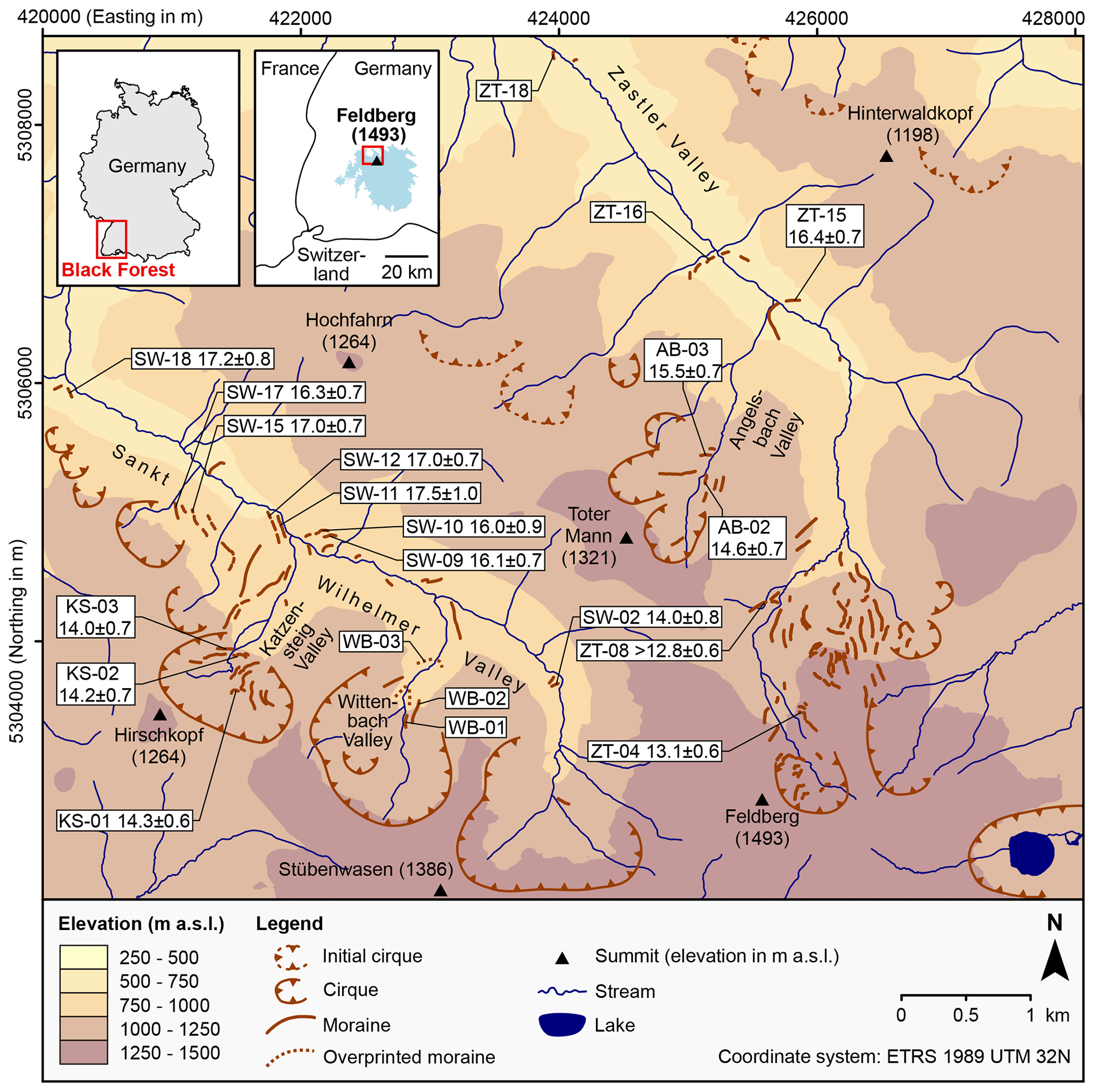
Figure 1Glacial landforms in the region NW of Feldberg (Hofmann et al., 2020, 2022, 2023). CRE ages of moraines and external uncertainties (Hofmann et al., 2022, 2023) are given in thousands of years (ka) before 2010 CE and ka, respectively. The inset maps show the location of the Black Forest and the Late Pleistocene maximum ice extent (light-blue polygon) according to Hemmerle et al. (2016).
Large boulders on moraines and erratic boulders were selected for 10Be cosmic-ray exposure (CRE) dating. As numerous sampling sites lay in heavily forested areas, topographic shielding factors were determined with DEMs following Li (2018) and the guidelines of Hofmann (2022). According to preliminary CRE ages of erratic boulders and moraine boulders SE of Feldberg, glacier retreat from the Late Pleistocene maximum position may have been underway by ∼ 21 ka at the latest. This working hypothesis needs to be confirmed with additional data. In the region NW of Feldberg (Fig. 1), the timing of this glacial phase remains currently unknown. The presumably oldest moraines in the Zastler Valley were devoid of suitable boulders for dating (Fig. 1). In the neighbouring Sankt Wilhelmer Valley, moraines at the Late Pleistocene maximum position have probably not been preserved. CRE ages of moraines NE of Feldberg cluster around 17–16, 15–14 and 13 ka, indicating three distinct periods of successive ice-marginal stability during the last deglaciation (Fig. 1; Hofmann et al., 2022, 2023).
Reconstructing DEMs of glacier surfaces and equilibrium line altitudes (ELAs) revealed that, during the period of valley glaciation in the region NW of Feldberg (by 17–16 ka at the latest), the ELAs varied between 1140 and 1160 m a.s.l. During the subsequent period of cirque glaciation (no later than 15–14 ka), the ELAs of glaciers ranged from 1150 to 1210 m a.s.l. with no clear spatial trend across the studied valleys. Varying sizes of snow drift and avalanche catchments of glaciers explain the best spatial variations in ELAs. Due to the strong effect of these processes on ELAs and large errors in the precipitation–temperature equation used, additional work is needed for realistic and more precise estimates of annual precipitation (Hofmann et al., 2022, 2023).
This study allowed for reconstructing the Late Pleistocene glacial history of the southern Black Forest in unprecedented detail. The high potential for climate reconstructions warrants further studies in this region. They should particularly focus on obtaining additional data on the Late Pleistocene glaciation maximum and on extracting a climatic signal from ELAs of glaciers.