the Creative Commons Attribution 4.0 License.
the Creative Commons Attribution 4.0 License.
 | 18 Jul 2024
Older than expected: fluvial aggradation of the Rhine's main terrace at Kärlich dated around 1.5 Ma by electron spin resonance
Mathieu Duval
María Jesús Alonso Escarza
Gilles Rixhon
- Article
(4157 KB) - Full-text XML
-
Supplement
(546 KB) - BibTeX
- EndNote


Bartz, M., Duval, M., Alonso Escarza, M. J., and Rixhon, G.: Older than expected: fluvial aggradation of the Rhine's main terrace at Kärlich dated around 1.5 Ma by electron spin resonance, E&G Quaternary Sci. J., 73, 139–144, https://doi.org/10.5194/egqsj-73-139-2024, 2024.
The Mülheim–Kärlich clay pit (Kärlich hereinafter) is located along the Middle Rhine Valley (MRV), about 10 km north-westward of the city of Koblenz (Fig. 1a). Owing to its > 30 m thick Quaternary sequence (Fig. 1b), it perhaps represents the most significant sedimentary profile along this entire valley reach. The sequence provides key information on long-term landscape evolution in the MRV, including successive fluvial aggradation phases related to the so-called main terraces of the Rhine and the Moselle (e.g. Boenigk and Frechen, 2006, 1998), and is also relevant for its archaeological and palaeoenvironmental record (e.g. Gaudzinski et al., 1996). Despite this importance, the quality of chronological constraints on the whole Quaternary sequence is far from being uniform (Fig. 1b). dating of three tephra layers interspersed in loess and loess-like sediments yields ages ranging from ∼ 0.47 to ∼ 0.36 Ma (Van Den Bogaard et al., 1989; Gallant et al., 2014; Fig. 1b) for the upper part of the Middle Pleistocene sequence. Whilst intermediate units can be tentatively correlated to Marine Isotope Stages (MISs) 16–12 based on biostratigraphy and on the composition of volcanic mineral assemblages (Boenigk and Frechen, 1998), there is no numerical age control on the fluvial sequence at the base (Fig. 1b). It is merely constrained by questionable palaeomagnetic data suggesting a minimum age of 0.77 Ma (all geomagnetic boundaries are from Channell et al., 2020), corresponding to the Brunhes–Matuyama boundary (e.g. Boenigk and Frechen, 1998). Altogether, the lack of a reliable chronological framework for the fluvial units is highly problematic since Rhine deposits at Kärlich were often used as a reference site for a key terrace level in the Quaternary evolution of the river, the so-called main terraces (Boenigk and Frechen, 2006). This study thus aims to fill this gap by applying electron spin resonance (ESR) dating of quartz grains from two sediment samples of the Rhine's main terrace. This new age control further refines the whole Kärlich chronostratigraphy and numerically constrains, for the first time, the aggradation time of key terrace deposits along the MRV.
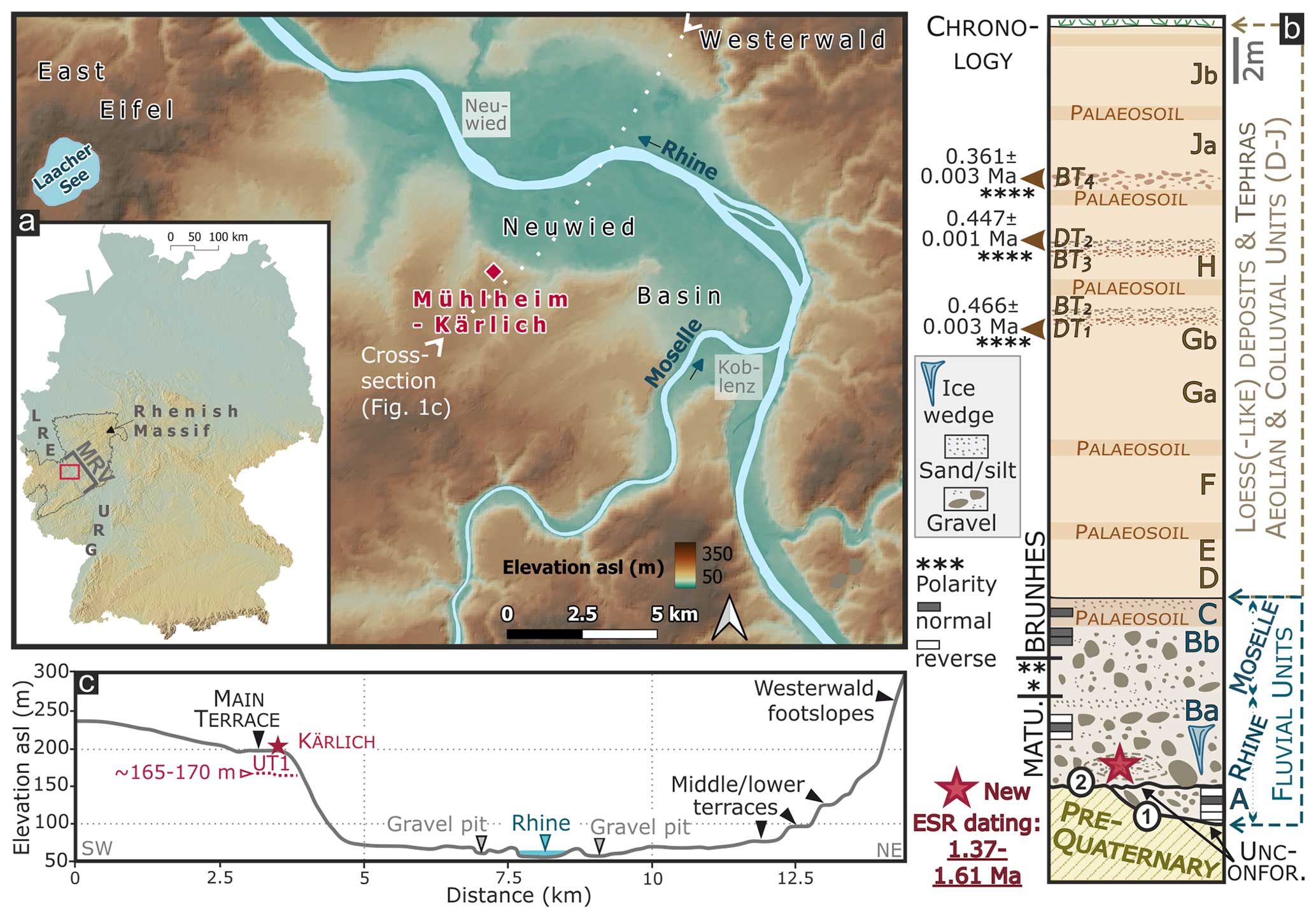
Figure 1(a) Location map of the Kärlich site in the Neuwied Basin. Insert: location of the Neuwied Basin along the Middle Rhine Valley (MRV) in Germany (Lower Rhine Embayment – LRE, Upper Rhine Graben – URG). DEMs from Sonny (sonny.4lima.de) and Copernicus (doi:10.5270/ESA-c5d3d65) are used. (b) The simplified log and chronology of the Quaternary sedimentary sequence (units A to J) at Kärlich are adapted from Van Kolfschoten and Turner (1996), with the red star indicating the ESR sample location (modified after Boenigk and Frechen, 1998; Van Kolfschoten and Turner, 1996; and Gallant et al., 2014). DT1–2 and BT2–4 refer to tephra layers according to Gallant et al. (2014). ∗ Boenigk and Frechen (1998), Van Kolfschoten and Turner (1996), Schirmer (1990), and Gallant et al. (2014). (c) Cross-section of the Rhine Valley across the Neuwied Basin, highlighting the prominence of the main terrace (UT1, sampled at Kärlich) in the fluvial landscape. Palaeomagnetic data and their tentative correlation to the geomagnetic polarity timescale should be treated with caution (see main text).
2.1 Geomorphological setting
The ∼ 120 km long MRV is the reach deeply incised into Palaeozoic rocks of the uplifted Rhenish Massif, and the Neuwied Basin is roughly located at its mid-length (Fig. 1a). Over Plio–Quaternary timescales, this basin has experienced less uplift than the upstream and downstream reaches, resulting in a smaller vertical spacing in the Rhine terrace sequence along this ∼ 25 km long reach (Boenigk and Frechen, 2006). Among this sequence (Fig. 1c), the main terrace complex (i.e. “upper terraces” of Boenigk and Frechen, 2006) (i) is composed of three well-developed, closely spaced terrace levels and (ii) forms a clear morphological transition across all major valleys draining the Rhenish Massif (i.e. upper broad vs. lower narrow valley walls; Fig. 1c). It thereby represents a widespread geomorphologic marker probably related to a massif-wide tectonic pulse (e.g. Rixhon and Demoulin, 2018). Rhine sediments identified at the base of the Quaternary sequence at Kärlich are traditionally assigned to the main terrace's older level (e.g. Gaudzinski et al., 1996), or Ältere Hauptterrasse, also labelled UT1 (Fig. 1c; Boenigk and Frechen, 2006).
2.2 Quaternary sequence
The Kärlich pit is located in the western part of the Neuwied Basin (50° N, 7° E; Fig. 1a). While the top-surface elevation lies at ∼ 200 m a.s.l. (Fig. 1c), the overall thickness of Quaternary sediments slightly exceeds 30 m (Figs. 1b, 2a). As normal faulting related to tectonic activity of the Neuwied Basin affects the pre-Quaternary sequence and the basal fluvial gravels (Fig. 2b), elevation of the contact between Neogene and Quaternary sediments roughly ranges between 165 and 170 m a.s.l. (Fig. 1c). The lithostratigraphical units of Brunnacker et al. (1969) for the Quaternary sequence are still in use today (i.e. A–J from bottom to top). Units A, B, and C are all fluvial, and their overall thickness can reach 10 m (Fig. 2a). Two unconformities occur between Neogene sediments and fluvial units (Fig. 1b): the first one at the base of unit A and the second one at the top of unit A/base of unit B. Based on clast lithological and heavy-mineral analyses, units A–Ba and units Bb–C are attributed to the Rhine and the Moselle, respectively, with a mixed layer in between (Boenigk and Frechen, 2006). Abundant ice-rafted debris (Fig. 2c) and ice-wedge pseudomorphs (Fig. 1b) are observed at the base and top of Ba, respectively (Boenigk and Frechen, 1998; Fig. 1b). The main reverse-to-normal magnetic polarity change was positioned either at the boundary between the Rhine deposits (unit Ba) and the coarse Moselle (or mixed) deposits (unit Bb; e.g. Gaudzinski et al., 1996) or within the latter, more upward in the sequence (e.g. Van Kolfschoten and Turner, 1996; Fig. 1b). Units D–J are composed of alternating loess, loess-like, and slope deposits as well as tephras (Boenigk and Frechen, 1998). Various units (from A to J) have also delivered mammal fossil remains and lithic artefacts (see Supplement).
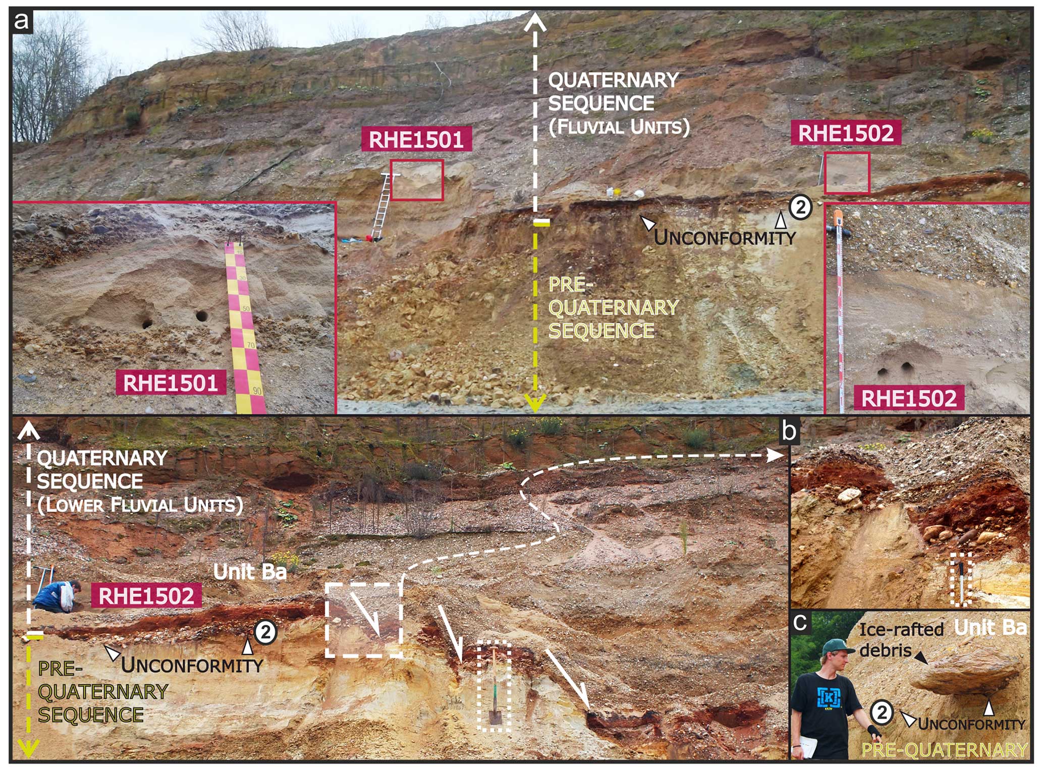
Figure 2Field pictures of the Kärlich site. (a, b) Position of the two ESR samples (vertically and horizontally distant by ∼ 0.7–0.8 m and ∼ 10 m, respectively) in sand lenses belonging to Rhine terrace sediments overlying the second unconformity (2; Fig. 1b) and avoiding the normal faulting (white downward arrows) affecting the pre-Quaternary sequence and basal fluvial deposits. (c) Ice-rafted debris located at the very base of unit Ba (all photos: G. Rixhon; scales – a: ladder, b: spade and pen, c: person).
Two ESR samples (RHE1501 and RHE1502) were collected in December 2015 from two sand lenses overlying the second unconformity (Fig. 2a). They were collected in unit Ba, i.e. the Rhine's older main terrace (UT1; Fig. 2b). Sample preparation and ESR dose evaluation were performed at the University of Cologne (Germany) and the National Research Centre on Human Evolution (CENIEH; Burgos, Spain), respectively. Quartz grains (100–250 µm) were dated via the multiple-aliquot additive-dose (MAAD) method and following the multiple-centre (MC; aluminium (Al) and titanium (Ti) centres) approach (Toyoda et al., 2000). A detailed description and explanation of the ESR methodology can be found in the Supplement.
4.1 Equivalent dose (DE) assessment
The Al and Ti signals show relatively strong intensities (Fig. 3a) and return consistent dose estimates for both samples (Table S1 in the Supplement). In accordance with the MC approach, these results show that the Al signal was most likely fully reset (i.e. reset up to its residual, unbleachable, ESR intensity) during sediment transport. Weighted-mean combined Al–Ti DE values of 2405±145 Gy (RHE1501) and 2163±158 Gy (RHE1502) can be calculated. The quality and reliability of the fitting results (Fig. 3b) are thoroughly discussed in the Supplement.
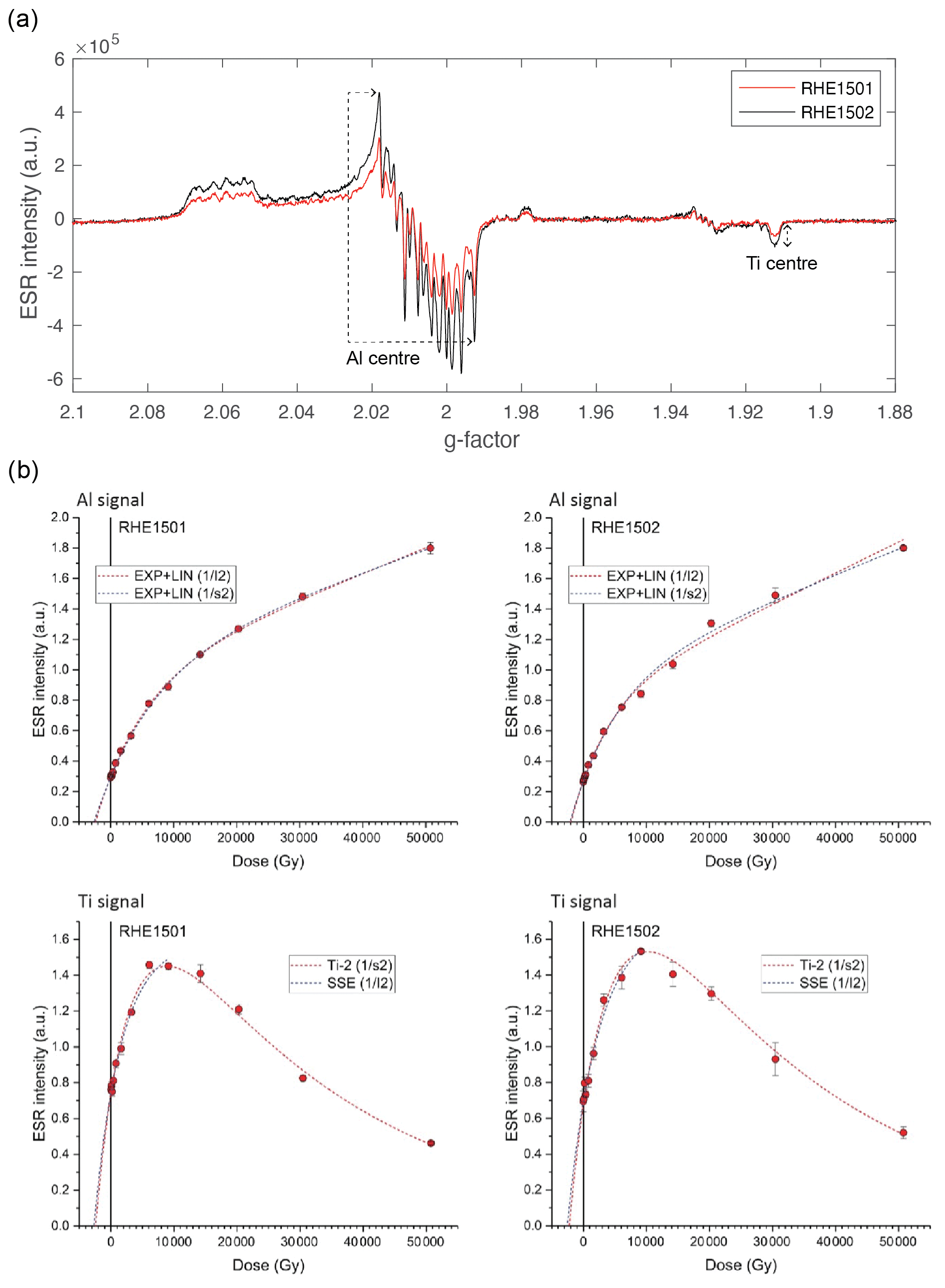
Figure 3(a) ESR spectra of the natural signals of samples RHE1501 (red) and RHE1502 (black). Al and Ti ESR intensity extraction is indicated by the dashed arrows. (b) ESR dose response curves of Al (top) and Ti (bottom) signals in samples RHE1501 (left) and RHE1502 (right).
4.2 Dose rate consideration
Sample RHE1501 shows higher radioelement concentrations and gamma dose rate (by ∼ 20 %) compared to RHE1502 (Table 1). The gamma dose rate values derived from in situ measurements and laboratory analyses are consistent for sample RHE1502, whereas they differ by ∼ 23 % for RHE1501. This difference most likely originates from the heterogeneity of the surrounding environment (Fig. 2a), since a activity ratio close to unity (within ±5 %; Table 1) indicates that the 238U decay chain is in secular equilibrium (for both samples).
4.3 ESR age estimates
ESR age calculations are based on two geomorphologic scenarios (Table 1), accounting for two extreme cosmic dose rate evaluations. We consider a burial depth either under ∼ 8 m of fluvial deposits only (scenario A; minimum age estimate) or under the ∼ 30 m thick Quaternary sequence (scenario B; maximum age estimate). Samples RHE1501 and RHE1502 yield ESR ages of 1.39±0.11 (A) and 1.44±0.11 (B) and 1.51±0.13 (A) and 1.58±0.14 Ma (B), respectively (Table 1). For each scenario, the results of the two samples agree at 1σ. As both samples were collected from unit Ba, average ages of 1.45±0.08 (A) and 1.51±0.10 Ma (B) can be calculated. Both scenarios provide consistent results, showing that the uncertainty in the cosmic dose rate has a limited impact on the calculated ESR ages. Considering the 1σ standard deviations of the average ages, we thus assume an aggradation time for the base of UT1 ranging between 1.37 and 1.61 Ma (Fig. 1b).
Table 1ESR age estimates and dose rate components. Details can be found in the Supplement. Errors are 1σ.
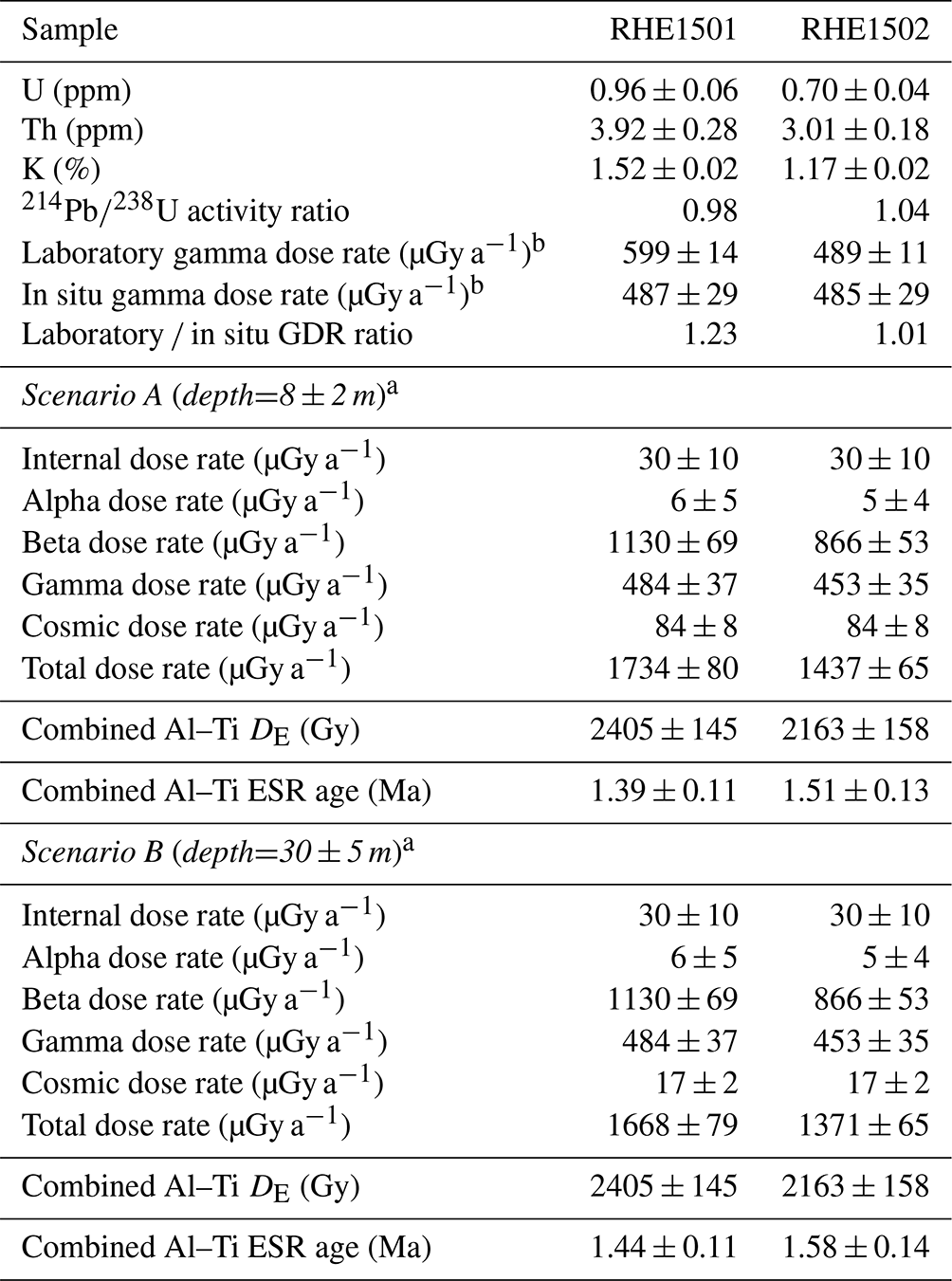
a Depths below the top of fluvial deposits and the top of the whole sequence were
estimated to be 8±2 m (minimum depth) and 30±5 m (maximum depth), respectively. b Based on the measured water content.
The new consistent ESR age estimates obtained from the basal part of the Quaternary deposits at Kärlich have far-reaching implications at different geomorphic scales.
At the profile scale, ESR dating helps to further refine the chronostratigraphy of the whole sequence by providing, for the first time, an aggradation time around 1.5 Ma for the Rhine deposits (unit Ba). On the one hand, new age estimates are compatible with the ages constraining multiple tephra depositions in the overlying Middle Pleistocene sequence (Fig. 1b). On the other hand, they introduce a ∼ 0.7 Myr time gap with the long-lasting chronological interpretations inferred from palaeomagnetic measurements performed in the fluvial units and strongly call these into question. Almost all previous studies have agreed on a reverse-to-normal polarity change assigned to the Brunhes–Matuyama boundary (Fig. 1b), positioned either at the boundary between the Rhine and Moselle deposits (i.e. ; e.g. Schirmer, 1990; Gaudzinski et al., 1996; Boenigk and Frechen, 1998) or within Bb (e.g. Van Den Bogaard et al., 1989; Van Kolfschoten and Turner, 1996). If the ESR chronology is partly compatible with the palaeomagnetic results by correlating the reverse polarity identified in units A and Ba to the Matuyama Chron, any further chronological interpretation would be very speculative given obvious limitations inherent to previous palaeomagnetic datasets. These limitations involve not only the very low sampling resolution (e.g. Fromm, 1987, only measured eight samples dispersed throughout all fluvial units) but also the impossibility to critically assess the quality of the dataset due to insufficient reporting details. In any case, our new numerical age estimates call for future dating efforts to refine the overall chronostratigraphy. This also entails more complete palaeomagnetic measurements, in accordance with the standards of the field (e.g. Opdyke and Channell, 1996).
At the valley scale, the 1.37–1.61 Ma time span dating the onset of the aggradation episode related to the Rhine's oldest main terrace (i.e. UT1) encompasses MISs 55 to 44 (Cohen and Gibbard, 2019). Moreover, ice-wedge pseudomorphs and other cryoturbations observed in the upper part of unit Ba (Boenigk and Frechen, 1998) along with abundant ice-rafted debris at its base (Fig. 2c) strongly point to UT1 formation during cold conditions, i.e. MISs 54, 52, 50, 48, 46, or 44. On the one hand, this new age attribution matches Schirmer's (1990) interpretation, for whom this unit represents the oldest evidence of full glacial conditions along the MRV, well. On the other hand, it clearly casts doubt on the usual correlation found in the literature between UT1 and MIS19 (e.g. Boenigk and Frechen, 2006). UT1 aggradation, hence the formation of the MRV's main terraces, is much older than previously thought. In any case, our new numerical age estimates call for future dating efforts to better constrain the formation time span of the Rhine's main terrace complex, not only along the MRV but also in the Lower Rhine Embayment where it is recognised as well (Fig. 1a; Boenigk and Frechen, 2006).
At the regional scale, our new age estimates must be compared to the few existing ones for fluvial deposits building the main terrace complex of the main rivers draining the Rhenish–Ardennes Massif. First, ESR dating (based only on the Al centre though) allocates an age of ∼ 1.2 Ma to the younger level of the main terrace perched above the Moselle–Saar confluence further upstream in the Rhenish Massif (Cordier et al., 2012). While this numerical result should be regarded as a maximum possible age (as per the MC approach), it does not seem incompatible with the present results given the ∼ 0.2–0.3 Myr time gap between UT1 along the MRV and Moselle–Saar's younger main terrace. Second, cosmogenic-nuclide age estimates exist for the younger main terrace in the Ardennian Meuse catchment located in eastern Belgium (i.e. the western part of the Rhenish Massif). Regardless of the method and the sampling location used along the main trunk or the main intra-massif tributaries, i.e. 10Be and 26Al depth profiles in fluvial terrace deposits (Rixhon et al., 2011) or burial dating of alluvium trapped in cave levels correlated to the younger main terrace (Rixhon et al., 2020), all age estimates indicate a formation during the Middle Pleistocene. Owing (partly) to the new results presented here, we highlight, for the first time, a massif-wide chronological discrepancy. Age control on the widespread geomorphologic marker that is the main terrace complex seems to reveal a time lag of several hundreds of kiloyears between the Massif's south-eastern part drained by the Rhine and Moselle (Germany) and its north-western part crossed by the Meuse (Belgium). Whether this diachronous fluvial incision argues for Demoulin and Hallot's (2009) hypothesis of a Quaternary uplift wave migrating northward throughout the whole Rhenish–Ardennes Massif requires, anew, more numerical age estimates on key geomorphologic markers.
To sum up, this short contribution presenting the first ESR ages on optically bleached quartz grains from Kärlich highlights (i) the need for numerical dating methods and (ii) the usefulness of ESR dating via the MC approach in providing robust chronological tie points in Quaternary sedimentary sequences. Our consistent results provide a first constraint on the aggradation time of a key geomorphologic marker along the MRV. Further dating of the main terrace complex, especially its lower level (i.e. younger main terrace), and of other terrace subsets, located both above and below this complex in the terrace staircase, is in progress with the aim of better understanding long-term fluvial responses to complex interplays between tectonic and climatic forcing.
All data are shown in this express report and its Supplement.
The supplement related to this article is available online at: https://doi.org/10.5194/egqsj-73-139-2024-supplement.
GR and MD initiated the project. MB received funding from the Horizon 2020 Programme of the EU (Iperion HS). MB, MD, and GR took part in the field trip and wrote the paper. MJAE carried out the ESR measurements. MJAE, MD, and MB evaluated the ESR data.
At least one of the (co-)authors is a member of the editorial board of E&G Quaternary Science Journal and a guest member of the editorial board for the special issue “Quaternary research in times of change – inspired by INQUA Roma 2023”. The peer-review process was guided by an independent editor, and the authors also have no other competing interests to declare.
Publisher’s note: Copernicus Publications remains neutral with regard to jurisdictional claims made in the text, published maps, institutional affiliations, or any other geographical representation in this paper. While Copernicus Publications makes every effort to include appropriate place names, the final responsibility lies with the authors.
This article is part of the special issue “Quaternary research in times of change – inspired by INQUA Roma 2023”. It is a result of the INQUA conference, Rome, Italy, 14–20 July 2023.
Financial support by the access to research infrastructures activity in the Horizon 2020 Programme of the EU (IPERION HS grant agreement no. 871034) is gratefully acknowledged. This work is associated with the following grants: (i) PID2021-123092NB-C22, funded by MCIN/AEI/10.13039/501100011033/ and the ERDF's A Way of Making Europe project, and (ii) RYC2018-025221-I, funded by MCIN/AEI/10.13039/501100011033 and the ESF's Investing in Your Future project. Anja Zander (University of Cologne) is gratefully acknowledged for carrying out the HRGS analyses. We thank Olaf Jöris for the constructive review.
This research has been supported by the Horizon 2020 Programme (IPERION HS grant agreement no. 871034).
This paper was edited by Ingmar Unkel and reviewed by Olaf Jöris.
Boenigk, W. and Frechen, M.: The Pliocene and Quaternary fluvial archives of the Rhine system, Quaternary Sci. Rev., 25, 550–574, https://doi.org/10.1016/j.quascirev.2005.01.018, 2006.
Boenigk, W. and Frechen, M.: Zur Geologie der Deckschichten von Kärlich/Mittelrhein, Eiszeitalter und Gegenwart, 48, 38–49, 1998.
Brunnacker, K., Streit, R., and Schirmer, W.: Der Aufbau der Quartär-Profile von Kärlich /Neuwieder Becken (Mittelthein), Naturhistor. Museum, 8, 102–133, 1969.
Channell, J. E. T., Singer, B. S., and Jicha, B. R.: Timing of Quaternary geomagnetic reversals and excursions in volcanic and sedimentary archives, Quaternaary Sci. Rev., 228, 106114, https://doi.org/10.1016/j.quascirev.2019.106114, 2020.
Cohen, K. M. and Gibbard, P. L.: Global chronostratigraphical correlation table for the last 2.7 million years, version 2019 QI-500, Quaternay Int., 500, 20–31, https://doi.org/10.1016/j.quaint.2019.03.009, 2019.
Cordier, S., Harmand, D., Lauer, T., Voinchet, P., Bahain, J. J., and Frechen, M.: Geochronological reconstruction of the Pleistocene evolution of the Sarre valley (France and Germany) using OSL and ESR dating techniques, Geomorphology, 165–166, 91–106, https://doi.org/10.1016/j.geomorph.2011.12.038, 2012.
Demoulin, A. and Hallot, E.: Shape and amount of the Quaternary uplift of the western Rhenish shield and the Ardennes (western Europe), Tectonophysics, 474, 696–708, https://doi.org/10.1016/j.tecto.2009.05.015, 2009.
Fromm, K.: Paläomagnetische Bestimmungen zur Korrelierung altpleistozäner Terrassen des Mittelrheins, Mainzer Geowiss. Mitt., 16, 7–29, 1987.
Gallant, C. E., Candy, I., Van Den Bogaard, P., Silva, B. N., and Turner, E.: Stable isotopic evidence for Middle Pleistocene environmental change from a loess-paleosol sequence: Kärlich, Germany, Boreas, 43, 818–833, https://doi.org/10.1111/bor.12065, 2014.
Gaudzinski, S., Bittmann, F., Boenigk, W., Frechen, M., and Van Kolfschoten, T.: Palaeoecology and Archaeology of the Kärlich–Seeufer Open-Air Site (Middle Pleistocene) in the Central Rhineland, Germany, Quaternary Res., 46, 319–334, https://doi.org/10.1006/qres.1996.0070, 1996.
Opdyke, N. D. and Channell, J. E. T.: Magnetic stratigraphy, Academic press, 346 pp., 1996.
Rixhon, G. and Demoulin, A.: The Picturesque Ardennian Valleys: Plio-Quaternary Incision of the Drainage System in the Uplifting Ardenne, in:Landscapes and Landforms of Belgium and Luxembourg, edited by: Demoulin, A., Springer International Publishing, Cham, 159–175 pp., https://doi.org/10.1007/978-3-319-58239-9_10, 2018.
Rixhon, G., Braucher, R., Bourlès, D., Siame, L., Bovy, B., and Demoulin, A.: Quaternary river incision in NE Ardennes (Belgium) – Insights from 10Be/26Al dating of river terraces, Quat. Geochronol., 6, 273–284, https://doi.org/10.1016/j.quageo.2010.11.001, 2011.
Rixhon, G., Braucher, R., Bourlès, D.L., Peeters, A., Demoulin, A., and Leanni, L.: Plio-Quaternary landscape evolution in the uplifted Ardennes: New insights from 26Al/10Be data from cave-deposited alluvium (Meuse catchment, E. Belgium), Geomorphology, 371, 107424, https://doi.org/10.1016/j.geomorph.2020.107424, 2020.
Schirmer, W.: Rheingeschichte zwischen Mosel und Maas, Deuqua-Führer, 1, 60–67 pp., 1990.
Toyoda, S., Voinchet, P., Falguères, C., Dolo, J. M., and Laurent, M.: Bleaching of ESR signals by the sunlight: a laboratory experiment for establishing the ESR dating of sediments, Appl. Ra. Isotop., 52, 1357–1362, https://doi.org/10.1016/S0969-8043(00)00095-6, 2000.
Van Den Bogaard, C., Van Den Bogaard, P., and Schmincke, H.-U.: Quartärgeologisch-tephrostratigraphische Neuaufnahme und Interpretation des Pleistozänprofils Kärlich, E&G Quaternary Sci. J., 39, 62–86, https://doi.org/10.3285/eg.39.1.08, 1989.
Van Kolfschoten, T. and Turner, E.: Early Middle Pleistocene mammalian faunas from Kärlich and Miesenheim I and their biostratigraphical implications, 1st Edn, CRC Press, https://hdl.handle.net/1887/10036 (last access: November 2023), 1996.