the Creative Commons Attribution 4.0 License.
the Creative Commons Attribution 4.0 License.
 | 16 Oct 2024
The Holocene evolution of the fluvial system of the southern Hessische Ried (Upper Rhine Graben, Germany) and its role for the use of the river Landgraben as a waterway during Roman times
Thomas Becker
Dennis Wilken
Peter Fischer
Timo Willershäuser
Lea Obrocki
Henrik Schäfer
Markus Scholz
Olaf Bubenzer
Bertil Mächtle
Andreas Vött
Appel, E., Becker, T., Wilken, D., Fischer, P., Willershäuser, T., Obrocki, L., Schäfer, H., Scholz, M., Bubenzer, O., Mächtle, B., and Vött, A.: The Holocene evolution of the fluvial system of the southern Hessische Ried (Upper Rhine Graben, Germany) and its role for the use of the river Landgraben as a waterway during Roman times, E&G Quaternary Sci. J., 73, 179–202, https://doi.org/10.5194/egqsj-73-179-2024, 2024.
Intensive human intervention in the natural drainage system of the Hessische Ried (Upper Rhine Graben, Germany) resulted in the transformation of a large wetland into an intensively used cultural landscape. At least since the first century CE, when Romans conducted early river regulation and water management, the natural water network has experienced extensive anthropogenic re-organisation. The LandGraben project focuses on the reconstruction of the natural and anthropogenic watercourse systems along the river Landgraben, a tributary to the river Rhine in the northern Hessische Ried. Several rivers from the southern Hessische Ried could have fed the river Landgraben during Roman times via the meandering Palaeo-Neckar depression, thus increasing both length and discharge of the Roman waterway.
In this study, we present results of our investigations within the southern Hessische Ried to reconstruct the former channel network that was used by Romans for the transportation of troops, wares and border security. Our approach integrates the use of high-resolution digital elevation models (DEMs) as a base for geophysical measurements (electrical resistivity tomography, ERT), direct push sensing and sediment coring in combination with sedimentological and geochemical analyses of the encountered sedimentary units. Local chronostratigraphies were established based on radiocarbon dating.
Based on our results, we are able to differentiate a palimpsest of several abandoned fluvial channels throughout the southern Hessische Ried and to reconstruct the spatio-temporal development of the corresponding fluvial systems. Chronostratigraphic data show that the Palaeo-Neckar stopped flowing through the Hessische Ried around 10 000 cal BCE. Moreover, we found that the river Weschnitz, the largest of the possible Landgraben tributaries, stopped flowing through the Palaeo-Neckar depression at ca. 3000 cal BCE. Instead, it took a right-angled shortcut westwards to the river Rhine, north of the city of Lorsch. For the first time, we present geomorphological evidence that the river Weschnitz was not diverted by the Romans as speculated so far. This is corroborated by numerous wooden posts of human-made construction crossing an E–W running water course at the modern Weschnitz knee, with the oldest posts being dendrochronologically dated to the fourth and third millennia BCE. We further argue that the river Winkelbach/Lauter formed its knee towards the river Rhine and thus left the Palaeo-Neckar depression not later than the second century CE but most probably even contemporaneously with the formation of the Weschnitz diversion. In the case of the Winkelbach/Lauter, a high-energy flood event presumably related to strong rainfall and/or meltwater processes in the Odenwald Mountains is assumed to be responsible for the initiation of the new, diverted water course. With regard to the Landgraben and its use as a waterway within the Roman fluvioscape of the Hessische Ried, we therefore conclude that the Romans successfully collected water from several smaller rivers, such as from the rivers Modau and Darmbach and from even smaller tributaries, to make the river Landgraben a navigable waterway. The rivers Weschnitz and Winkelbach/Lauter, however, did not contribute any water to the Landgraben system during Roman times.
Umfangreiche menschliche Eingriffe in das natürliche Entwässerungssystem des Hessischen Rieds (Oberrheingraben, Deutschland) führten zur Umwandlung eines weiträumigen Feuchtgebiets in eine intensiv genutzte Kulturlandschaft. Spätestens seit dem 1. Jahrhundert n. Chr., als die Römer Regulierungsmaßnahmen an Flüssen ergriffen, wurde das natürliche Gewässernetz tiefgründig umgestaltet. Das LandGraben-Projekt befasst sich mit der Rekonstruktion der natürlichen und anthropogenen Gewässerstrukturen entlang des Landgrabens, einem Nebenfluss des Rheins im nördlichen Hessischen Ried. Mehrere Flüsse aus dem südlichen Hessischen Ried könnten den Landgraben während der Römerzeit über die Altneckarniederung gespeist haben und damit sowohl die Länge als auch den Abfluss der römischen Wasserstraße vergrößert haben.
Diese Studie stellt die Rekonstruktion des ehemaligen Flussnetzes vor, das von den Römern für den Transport von Truppen, Waren und zur Grenzsicherung genutzt wurde. Unser Ansatz kombiniert hochauflösende digitale Geländemodelle, geophysikalische Messungen (Geoelektrische Widerstandstomographie), Direct Push Sensing und Sedimentkernbohrungen in Verbindung mit sedimentologischen und geochemischen Analysen der vorliegenden Sedimenteinheiten. Lokale Chronostratigraphien wurden auf der Grundlage von Radiokohlenstoffdatierungen erstellt.
Basierend auf unseren Ergebnissen konnte zwischen verschiedenen verlandeten Flussrinnen im südlichen Hessischen Ried differenziert und die raum-zeitliche Entwicklung der entsprechenden fluvialen Systeme rekonstruiert werden. Chronostratigraphische Daten zeigen, dass der Altneckar um ca. 10 000 v. Chr. aufhörte, durch das Hessische Ried zu entwässern. Bereits um ca. 3000 v. Chr. verließ die Weschnitz, der größte der möglichen Landgrabenzuflüsse, die Altneckar-Niederung. Stattdessen nahm sie nördlich von Lorsch eine rechtwinklige Abkürzung westwärts zum Rhein. Damit ist erstmals geomorphologisch nachgewiesen, dass die Weschnitz nicht, wie bisher vermutet, von den Römern umgeleitet wurde. Diese Annahme wird durch das Vorhandensein zahlreicher Holzpfähle unterstützt, die der Überquerung eines in Ost-West Richtung verlaufenden Fließgewässers am heutigen Weschnitzknie dienten. Für die ältesten dieser Pfähle liegen dendrochronologische Datierungen in das 4. und 3. Jahrtausend v. Chr. vor. Weiterhin konnte festgestellt werden, dass der Winkelbach bzw. die Lauter die Altneckar-Niederung jedenfalls vor dem 2. Jh. n. Chr. in Richtung Rhein verlassen hat und sein Knie bildete. Höchstwahrscheinlich geschah dies wesentlich früher, nämlich gleichzeitig mit der Entstehung des Weschnitzknies. Im Falle der Laufänderung von Winkelbach bzw. Lauter wird ein hochenergetisches Überflutungsereignis, vermutlich im Zusammenhang mit starken Niederschlägen und/oder Schmelzwasserprozessen im Odenwald verantwortlich gemacht. Im Hinblick auf den Landgraben und seine Nutzung als Wasserstraße in der römischen Flusslandschaft des Hessischen Rieds lässt sich festhalten, dass die Römer das Wasser mehrerer kleinerer Flüsse, unter anderem der Modau, des Darmbachs sowie weiterer kleinerer Nebenflüsse, sammelten, um den Landgraben schiffbar zu machen. Die Flüsse Weschnitz und Winkelbach bzw. Lauter hingegen führten dem Landgrabensystem in römischer Zeit kein Wasser zu.
- Article
(16559 KB) - Full-text XML
-
Supplement
(2329 KB) - BibTeX
- EndNote


The fluvial system of the Hessische Ried (Upper Rhine Graben, Hessen, Germany) has undergone massive human interventions during the past millennia. These processes resulted in the transformation of a large natural floodplain into an artificially structured and intensively used cultural landscape. Notably, the Romans conducted early river regulation and water management measures since the first century CE (Hanel, 1995). For them, the control over small rivers was crucial to provide access to, develop and maintain new territories in Germania magna. In some cases, modifications of natural river channels were necessary to keep a steady supply for newly built castra (small military fortresses), vici (civil settlements), and villae rusticae (agricultural manors) and to connect them to strategically important centres, like the large castrum (legionary base) of Mogontiacum (Mainz). There are numerous indications of such Roman river manipulations along the river Landgraben, a small, partially canalised river that runs through the northern Hessische Ried today. The river Landgraben initially follows the Palaeo-Neckar depression and then leaves this predefined structure, heading directly towards the river Rhine. Originally thought to have been built by Landgraf (Landgrave) Georg I (1567–1596), construction work along the river Landgraben in the 1930s revealed evidence of a Roman canalisation between the Roman fortress Auf Esch near Groß-Gerau in the east and the river Rhine in the west, connecting the military site with Mogontiacum (Hanel, 1995; Maurer, 2011). Archaeological evidence included Roman ceramic fragments excavated from the former riverbed and wooden stakes found along several hundreds of metres parallel to the river, likely functioning as bank reinforcements (Wettlaufer, 1934, 1937, quoted from Hanel 1995).
For the transportation of heavy wares such as large barrels that were, for example, found at the Roman fortress Auf Esch (Wenzel, 2009), road transport through the swampy Ried (German for swamp with reed) was difficult and more expensive, making waterways the preferred transportation routes. Thus, the depth, width and water volume of the river Landgraben must have been sufficient for the transportation of heavy loads using barges. Therefore, the main objective is to clarify whether or not the hydrogeographical constellation was different during Roman times.
Today, the largest tributary to the river Landgraben is the river Darmbach, disemboguing only ca. 2 km upstream of the Roman fortress Auf Esch. However, it has been hypothesised that during Roman times the Palaeo-Neckar river channel held more and larger rivers than today (Wagner, 1990; Maurer, 2011), which would have made the accessibility of the Hessische Ried via the river Landgraben much easier.
At present, there are three notable rivers that stem from the Odenwald Mountains, flow into the Palaeo-Neckar flood plain and then leave it to take a shorter route to the river Rhine. From south to north these are the rivers Weschnitz, Winkelbach/Lauter and Modau, leaving the Palaeo-Neckar channel ca. 26, 22 and 14 km south of the Roman fortress Auf Esch, respectively.
The main objective of this study is to reconstruct the spatio-temporal evolution of the fluvial system in the southern Hessische Ried, especially regarding (i) the river Weschnitz and the formation of the Weschnitz knee to the north of the city of Lorsch and (ii) the river Winkelbach (called Lauter within the Odenwald Mountains) and the formation of the Winkelbach knee near the city of Bensheim, in order to determine the role of these rivers concerning the flow conditions and the navigability of the river Landgraben during Roman times. Geoarchaeological, geophysical, sedimentological and geochronological investigations were carried out in three different study areas, namely in the area of the knee of the present river Weschnitz, in the downstream section of the river Winkelbach/Lauter and in the Palaeo-Neckar river channel near Alsbach-Hähnlein.
2.1 Geological and geomorphological overview
The Hessische Ried is situated in the northern Upper Rhine Graben between the river Rhine in the west, the river Main in the north, the Odenwald Mountains in the east and the river Neckar in the south. The Upper Rhine Graben is an area of subsidence whose tectonic activity began in the Eocene and continues to this day. The negative landform created by the rift system was filled with marine; brackish; lacustrine; and, starting in the Late Miocene, fluvial sediments (Eberle et al., 2017). During the Pleistocene, the Rhine deposited large amounts of sediment in the graben structure. The finer sandy fractions were blown out by prevailing Pleistocene westerly winds (Holzhauer et al., 2017). The sandy fraction accumulated in the form of parabolic dunes in the eastern Upper Rhine Graben. The river Rhine cut itself deeper into the unconsolidated sediments, creating terraces (Schmitt and Steuer, 1974; Erkens et al., 2009; Holzhauer et al., 2017; Pflanz et al., 2022). A late Weichselian Rhine terrace generation exists in the Hessische Ried, namely the Obere Niederterrasse (Upper Lower Terrace, t6 terrace; Dambeck, 2005; Erkens et al., 2009), which is depicted in the relative elevation model (Fig. 1, the terrace edge is visible as the transition between turquoise and white). In the wider study area, three meander generations of the river Rhine were formed since the early Holocene (Dambeck, 2005; Erkens et al., 2009). In former times, the river Neckar ran parallel to the Rhine from Heidelberg in the south to Trebur in the north. This Palaeo-Neckar riverbed is a relict landform, as today the Neckar flows into the Rhine near Mannheim to the west of Heidelberg, shortening its course by ca. 40 km linear distance (Fig. 1; Engel et al., 2022; Dambeck and Thiemeyer, 2002). The geological and geomorphological makeup of the Hessische Ried from west to east can be summarised as follows: Holocene Rhine floodplain, Pleistocene Upper Lower Terrace with Pleistocene aeolian sands and dune fields, Palaeo-Neckar floodplain, and Odenwald Mountains (Fig. 1).
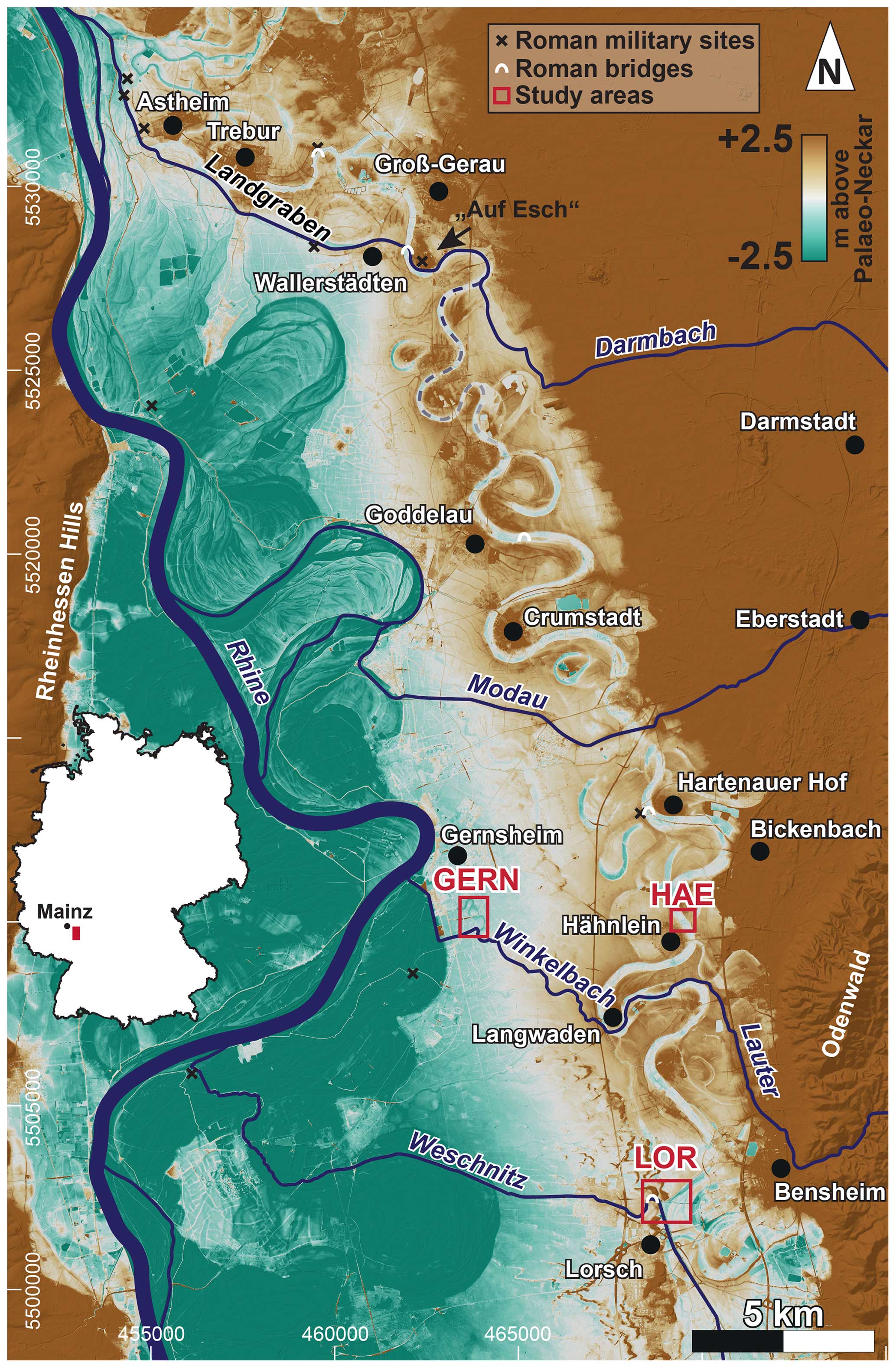
Figure 1Relative elevation model of the Palaeo-Neckar depression between Lorsch and Trebur. DEM source: HVBG 2023.
2.2 Climate and groundwater development
The climate of the Hessische Ried is characterised by warm summers and mild winters, with average annual temperatures of 11 °C and an average accumulated precipitation of 653 mm a−1 (derived from averaged individual monthly values of 1993–2022: Darmstadt, Frankfurt and Mannheim; Deutscher Wetterdienst, 2023). Precipitation generally increases from west to east and so does the climatic water balance (P–ET), which is overall positive (Ahner et al., 2013). With an average accumulated precipitation of up to 1100 mm a−1 (derived from annual values of 1992–2021; DWD Climate Data Center (CDC), 2023), the western Odenwald Mountains contribute major parts of the catchment runoff of the smaller Ried rivers. When Romans advanced into the Hessische Ried, precipitation in central Europe was likely higher than today. Drier conditions in the third century CE were followed by wetter climate during the following century (“Late Roman Pluvial” as described by Büntgen et al., 2011, 2021). Tree ring width data from the Upper Rhine Graben indicate that this was associated with high groundwater levels (Tegel et al., 2020).
Once a consistently wet and water-rich landscape, some agricultural and forested areas in the Hessische Ried are today characterised by artificial irrigation and groundwater infiltration required to secure the drinking water supply for the Rhine–Main area (Regierungspräsidium Darmstadt, 2020). The anthropogenic lowering of the groundwater table in the Hessische Ried began at the latest with the melioration measures of Landgraf Georg I in the late 16th century, during which the Landgraben was also remodelled (Anonymous, 1794; Noack, 1966). Also, the Rhine rectification (1817–1876) by Johann Gottfried Tulla led to further groundwater lowering in the Hessische Ried (Rösch, 2009). By the end of the 19th century, new drainage ditches helped to considerably increase the crop yield in the Hessische Ried (Mangold, 1892). Vast and intensive melioration measures were implemented again during the Third Reich on the basis of the Generalkulturplan (general culture plan) between 1933 and 1939 (Hanel, 1995). Since the 1960s, the groundwater level in the Hessische Ried has been substantially lowered by the abstraction of drinking water for the Frankfurt metropolitan area (Hessisches Ministerium für Umwelt, ländlichen Raum und Verbraucherschutz, 2005).
2.3 Fluvial development
2.3.1 Palaeo-Neckar
The Palaeo-Neckar used to flow into the river Rhine close to Trebur. Its former riverbed is up to 300 m wide and clearly visible in the field and through remote sensing. Mangold (1892) was the first to investigate the old course of the river Neckar using geodetic and sedimentological methods. He concluded that the Neckar moved its mouth into the Rhine after the Pleistocene because its channel was not filled with aeolian sands. More recently, the Neckar redirection was approximately dated to the transition between the Younger Dryas and the Preboreal (Bos et al., 2008). Following its abandonment, the smaller former Neckar tributaries (primarily Darmbach, Modau, Lauter and Weschnitz, from north to south) likely still used the Palaeo-Neckar bed – some authors even suggest until Roman times (Eckoldt, 1985; Wagner, 1990; Maurer, 2011).
2.3.2 Landgraben/Darmbach
The Landgraben is the northernmost tributary of the Palaeo-Neckar depression. From its source east of Darmstadt to where it meets the Palaeo-Neckar near Groß-Gerau it is called Darmbach and Landwehr (Fig. 2). Its total catchment area has a size of 145 km2 (watercourse identification number 23986; HLNUG, 2022). The Landgraben got its name in the 16th century when Landgraf Georg I (1567–1596 CE) initiated the construction of various canals with the aim of draining the Hessische Ried, making its lands more fertile and less prone to flooding (Herzberg, 1962; Noack, 1966). The Landgraben canals constructed at this time mostly ran in a straight line using the Palaeo-Neckar beds between Zwingenberg in the south and Wallerstädten in the north. To the west of Wallerstädten, the Landgraben leaves the Palaeo-Neckar, bending almost at a right angle across; crosses the Lower Rhine Terrace; and meets the Schwarzbach after approximately 6 km. Together they flow into the Rhine southwest of Ginsheim. Although both the 16th century version and the present version are called Landgraben, the only common course is the northernmost part, roughly between Groß-Gerau and Trebur. A map from 1561 CE shows that at least this northernmost section was not created by Landgraf Georg I but had already existed before, described as “river coming from Darmstadt” (Anonymous, 1561).
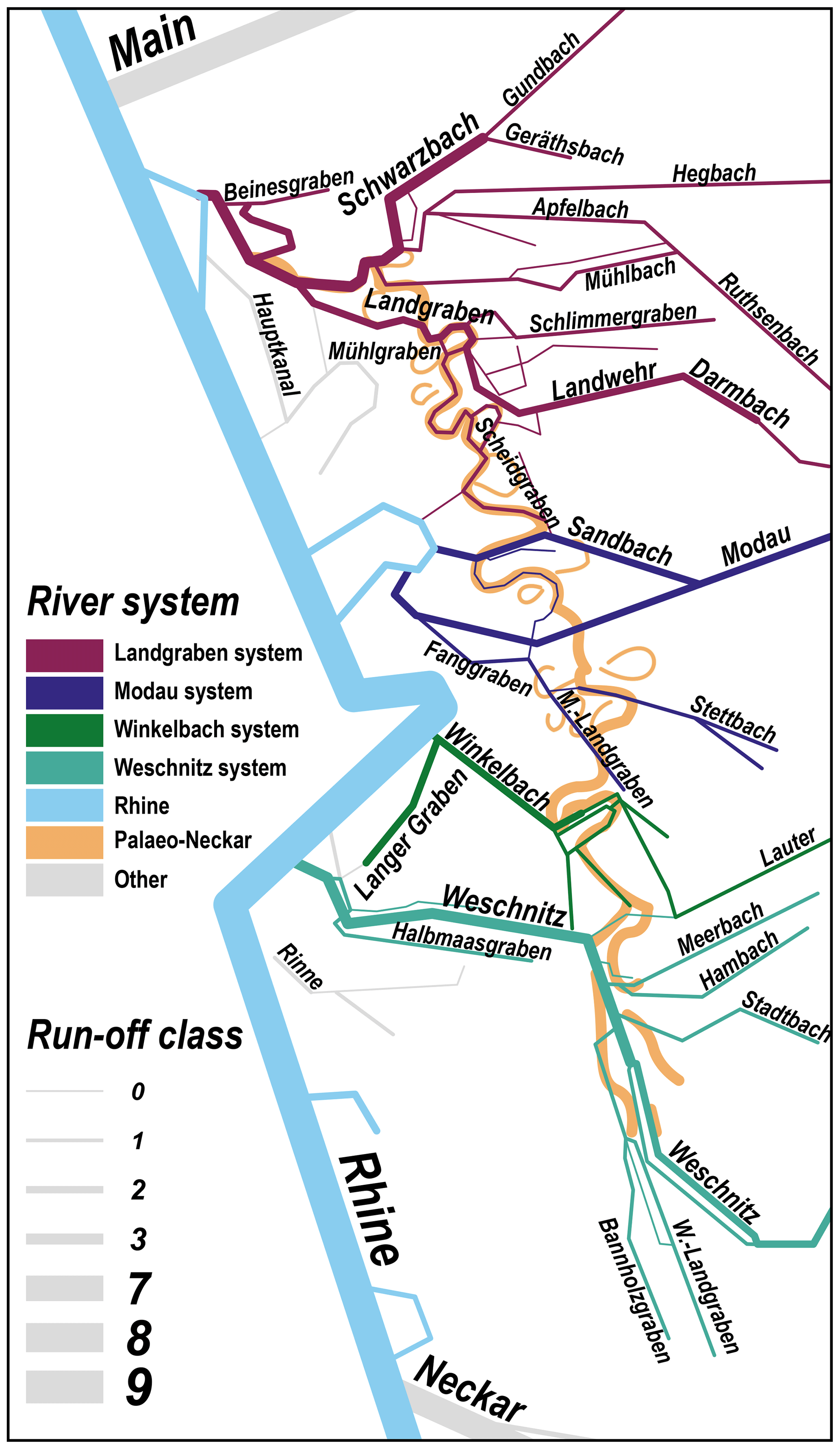
Figure 2Schematic map of current watercourses in the Hessische Ried. M.-Landgraben: Modau–Landgraben; W.-Landgraben: Weschnitz–Landgraben. Data source: HLNUG, 2022.
Due to numerous Roman finds, including wooden bank reinforcements along several hundreds of metres, discovered during cleansing measures in 1934 and 1937, Hanel (1995) suggests that this northern section of the Landgraben was engineered as a canal by the Romans. In addition, Roman bridge finds at the Landgraben (Fischer, 1978) and the burgus (plural burgi) of Trebur-Astheim, a fortified port (Heising, 2012; Becker et al., 2022; Wilken et al., 2023), clearly indicate that the river Landgraben itself was a navigable waterway during the fourth century CE. Recent geoarchaeological investigations in the environs of the burgus at Trebur-Astheim revealed that the Landgraben was finally abandoned in the sixth century CE at the latest (Appel et al., 2024).
The Darmbach is the largest tributary to the Landgraben. However, the Darmbach likely did not always reach the Landgraben. Between at least 1794 and 1882 its water percolated into the sands between Darmstadt and Griesheim, except during floods. From 1882 onwards, the Darmbach reached the Landgraben system again (Mangold, 1892). In recent times, the Darmstadt sewage treatment plant has contributed a large proportion of the Darmbach's water volume (Koenzen et al., 2021).
2.3.3 Modau
The source of the river Modau lies west of the village of Neunkirchen in the Odenwald Mountains. The total Modau catchment area is 205 km2 (watercourse identification number 23962; HLNUG, 2022). The river leaves the Odenwald Mountains at Eberstadt, flowing in a western direction. From here, the Modau turns southwest and crosses the Palaeo-Neckar depression almost perpendicularly while its subordinate branch, the Sandbach, runs 2.5 km along the Palaeo-Neckar course but opposite to its former flow direction. Both flow into the Kühkopf, an oxbow of the river Rhine.
Not much is known about former Modau courses. After the Neckar changed its path in the early Holocene, the Modau likely followed its abandoned northern course together with other Odenwald rivers, namely the Winkelbach/Lauter and the Weschnitz (e.g. Eckoldt, 1985). The Sandbach existed at least since 1567 CE as a secondary branch (Anonymous, 1567) and is used today as a flood relief system for the Modau (Wasserverband Modaugebiet, 2016).
2.3.4 Winkelbach/Lauter
Also, the river Winkelbach/Lauter has its source in the Odenwald Mountains. It is called Lauter until it enters the Hessische Ried at the city of Bensheim (watercourse identification number 23954; HLNUG, 2022). The size of the Winkelbach catchment area is 118 km2. At the Rinnentorturm (channel gate tower) in the inner city of Bensheim, it bends to the north and later crosses the Palaeo-Neckar depression south of Langwaden in order to flow directly westward into the river Rhine.
At the Rinnentor in Bensheim, there is another flow option towards the west, the so-called Neuer Graben (New Ditch) which flows into the river Weschnitz at the so-called Wattenheimer Brücke (Wattenheim Bridge) right at the Weschnitz knee (Figs. 1 and 2). The Rinnentor was part of the medieval city wall from the 13th/14th century (Landesamt für Denkmalpflege Hessen, 2024) onwards. It was probably used like a switch to guide the Winkelbach either towards the north (Rhine) or towards the west (Weschnitz). In 1621, the river was redirected westward for a short time for defensive purposes at the beginning of the Thirty Years' War (Stoll, 1939).
2.3.5 Weschnitz
The Odenwald-born river Weschnitz enters the Hessische Ried in the city of Weinheim and flows northwards to the north of Lorsch, where it takes a sharp turn westwards. Here, at the Weschnitz knee, it breaks through a belt of parabolic dunes and, after ca. 17 km, flows into the Rhine close to the ruins of the Roman burgus Zullestein (Figs. 1 and 2). The size of the Weschnitz catchment area is 330 km2 (watercourse identification number 2394; HLNUG, 2022).
After the Neckar had changed its course shortly before the beginning of the Holocene, the Weschnitz still flowed northwards using the Palaeo-Neckar bed. Solving the question of when the Weschnitz left the Palaeo-Neckar bed towards the west and created its knee is one of the main topics of this paper. So far, there are some arguments that speak for a Weschnitz redirection during Roman times (e.g. Eckoldt, 1985) and other arguments that prioritise a redirection already during prehistoric times (e.g. Helfert, 2014). Between 1535 and 1544, a new Weschnitz was built parallel to the already existing old Weschnitz, dividing the river water between both beds (Koob, 1956). Recent river works along the Weschnitz are associated with renaturation measures, creating artificial meanders near the Wattenheimer Brücke (completed 1999 and 2007; Hartnagel et al., 2014), at the so-called Weschnitzinsel (Weschnitz Island, completed 2017; Hessische Landgesellschaft mbH, 2024) and between the villages of Einhausen and Biblis (planned).
To sum up, the knowledge of the Holocene development of the Odenwald rivers that feed the southern Hessische Ried is scarce. Historical information on fluvial aspects, if ever available, does not cover periods prior to the 16th century CE. Old maps of the region show that the general flow direction has been the same since around 1600 (Anonymous, 1600; Lichtenberg, 1712).
Apart from historical sources, archaeological bridge finds may also help to reconstruct palaeogeographical settings. In the Hessische Ried, wooden posts that possibly belonged to a bridge were found at the Wattenheimer Brücke and date back to the fourth millennium BCE (Hartnagel et al., 2014; Helfert, 2014). During Roman times, further bridges were built (Fig. 1), for example, close to Riedstadt-Goddelau (river bridge; Wagner, 1990), Wallerstädten (river bridge; Fischer, 1978) and Bickenbach (swamp bridge; Geyer et al., 1977; Göldner, 2002).
2.4 Settlement development
Sparse finds from the Hessische Ried indicate the presence of humans since the Palaeolithic. In contrast, numerous sites are known from the early Neolithic onwards. The area continued being inhabited throughout the Bronze Age and Iron Age (Fiedler, 1984; Breitwieser et al., 2006; Singer, 2006). The Hessische Ried was intensively settled during the Iron Age. Thus, when the Romans arrived, they found a largely deforested, agricultural landscape (Maurer, 2011).
During Roman times, the border between the Roman Empire and the territories east of the river Rhine, which were settled by a Germanic or Celtic indigenous population, was shifted forward to the east several times, with the Hessische Ried being part of the border region or close to it between 1 BCE/CE and 400 CE. After settlements on the right bank of the river Rhine prospered in the second century CE, internal political unrest and Germanic raids led to a retreat of the Romans from the region during the middle third of the third century. Settlements were abandoned at the latest with the fall of the Limes around 260 CE. Under the emperor Diocletian (284–305), the internal political tensions were largely eliminated and military structures stabilised, so the area on the right bank of the Rhine was resettled by Germanic tribes in the fourth century CE (Baatz, 2002b; Breitwieser et al., 2006). Throughout this period, the small Rhine tributaries played an important role in transportation (Baatz, 2002a; Becker, 2019). As an example, the river Weschnitz is believed to have been used to transport granite columns weighing up to 30 t from the Felsberg (Odenwald) and marble blocks from the quarry near Hochstädten-Auerbach to Trier for the extension of the Constantinian double basilica under Constantine the Great (306–337 CE) (Eckoldt, 1985; Jorns, 1985; Plößer, 1993). In order to keep the rivers navigable in the fourth century CE, Germanic settlers in the Hessische Ried (laeti) are believed to have cleaned the rivers and kept the towpaths clear (Nenninger, 2001). Valentinian I's fortress-building programme, which began in 369 CE, marked the fortification of the river Rhine as the border and included construction of the Zullestein and Astheim burgi, which were located at the mouths of the Weschnitz and Landgraben/Schwarzbach into the Rhine, respectively (Schleiermacher, 1942; Heising, 2012; Becker et al., 2022; Wilken et al., 2023). These burgi made it safe to land warships and transport ships on the eastern riverbank during late Roman conflictual times (Baatz and Herrmann, 2002; Maurer, 2012). Prams had a flat bottom and end ramps and thus combined a high loading capacity with a shallow draught of only few decimetres. Due to their design, they could be moored on the shore by “slipping on” (Wawrzinek, 2016).
The UNESCO world heritage of Lorsch Abbey was founded in 764 CE in the southern Hessische Ried in the immediate vicinity of the navigable river Weschnitz. Until 1248 it was an important supra-regional political, economic and cultural centre with a total of ca. 3800 properties between the North Sea and the Alps (Helfert, 2014; Schenk, 2021). The maintenance of the rivers as important transportation routes was continued in the Carolingian period, similar to the late Roman period, by local residents and later by ship guilds (Nenninger, 2001). From 1248, the monastery lost its supra-regional importance after being settled by Premonstratensians and was finally destroyed by Spanish troops in 1621 (Schefers, 2020). In 829 CE, the Königspfalz (royal palace) of Trebur was founded next to the Landgraben/Schwarzbach. This waterway certainly was of high importance for the choice of the location (Becker et al., 2024).
The reconstruction of the fluvial dynamics of the Palaeo-Neckar and its successors was accomplished through a multi-proxy approach. To identify palaeochannels within the Palaeo-Neckar depression, we calculated an elevation model relative to the Palaeo-Neckar using the IDW method with a 150 m chainage (after Coe, 2019) and 1 m resolution lidar images provided by HVBG (2023). We then used a multi-electrode geophysical device (Syscal R1 Plus Switch 48, Iris Instruments) to conduct electrical resistivity tomography (ERT) measurements based on a Wenner–Schlumberger configuration with an electrode spacing of 0.5 and 1 m for ERT transect HAE ERT 17 and for ERT transects HAE ERT 1, 2, 6 and 7, respectively. The ERT data were inverted and merged using the RES2DINV software.
Direct push logging (DP) was conducted at six locations (LOR DP 8; GERN DP 1; HAE DP 1, 3, 4, 5) with a 540MT system (Geoprobe) mounted on an automotive drill rig (type RS 0/2.3, Nordmeyer) using the HPT K6050 hydraulic profiling tool (HPT, Geoprobe). With this HPT system, we measured electrical conductivity (DP EC) by means of four vertically arranged electrodes in a Wenner array as well as the hydraulic injection pressure (DP HPT) through injecting water at a constant flow rate (McCall, 2011; Geoprobe Systems, 2015; Obrocki et al., 2020), with both parameters at a vertical resolution of 2 cm. DP EC values (mS m−1) were converted into electrical resistivity values (Ωm).
We recovered sediment cores from three different study areas, namely cores LOR 8A and LOR 11A near the Wattenheimer Brücke, core GERN 1A near Gernsheim, and cores HAE 1A and HAE 3A near Hähnlein in an abandoned Palaeo-Neckar channel. We used a coring system consisting of closed steel augers in combination with plastic inliners (50 mm diameter). Positions of DP and coring sites were determined with a differential global positioning system (HiPer V and MAGNET Field software, TOPCON).
After we opened, cleaned and photographed the sediment cores, geomorphological, sedimentological and pedological characteristics were described (Barsch et al., 2000; Ad-hoc-Arbeitsgruppe Boden, 2005). Sediment samples were extracted for grain size analysis using the Köhn method (Köhn, 1929; DIN ISO 11277, 2002) and the determination of loss-on-ignition (LOI) values at 550 °C (Schlichting et al., 1995; Blume et al., 2011).
We further determined colour, magnetic susceptibility and element concentrations on freshly opened sediment cores. We used the CM-600d portable spectrophotometer (Konica Minolta) at a vertical resolution of 1 cm to measure sediment colours in the CIELAB colour space, which consists of lightness (L*), red–green (a*) and yellow–blue (b*) values. Also, the volume-specific magnetic susceptibility (MS) was determined using the MS2K surface sensor (Bartington) at a resolution of 1 cm. Magnetic susceptibility is indicative of provenance as well as weathering processes (e.g. Scheidt et al., 2020). Moreover, we measured semi-quantitative concentrations of 33 elements using the portable X-ray fluorescence (XRF) device Niton XL3t GOLDD (Thermo Fisher Scientific) in soil mode (10 s main filter; 10 s high filter; 10 s low filter) at a 2 cm resolution. In addition, fluvial sands of cores HAE 1A and HAE 3A were measured in mineral mode (20 s main filter; 40 s light filter) with a resolution of 1 cm, yielding seven further elements. Data obtained by portable XRF devices are regarded as semi-quantitative and may show minor shifts when compared to other methods. However, normalised XRF data are commonly used in palaeoenvironmental studies, mostly in the form of element-to-element ratios independent from grain size; they provide high-resolution information on the chemical composition of sediments and changing environmental conditions (EPA, 2007; Chagué-Goff et al., 2017; Judd et al., 2017). For another eight bulk samples extracted from fluvial sands of cores HAE 1A and HAE 3A (Fig. 10), the carbonate content was determined using a Scheibler apparatus (e.g. Blume et al., 2011; DIN EN ISO 10693, 2014). Additionally, 0.4 g of the pulverised sample, together with 5.2 g lithium tetraborate, was melted and poured into a tablet form for measurements with the stationary XRF MagiX PRO (PANalytical).
Finally, accelerator mass spectrometry (AMS) radiocarbon analyses were conducted for 26 charcoal, wood and plant fragments at the Curt-Engelhorn-Zentrum Archäometrie gGmbH Mannheim (MAMS). The CALIB software version 8.20 with the IntCal20 calibration curve was used for calibration of the 14C ages (Stuiver and Reimer, 1993; Reimer et al., 2020).
Based on the geomorphological, sedimentological and geochemical analyses of sediment cores collected from the three study areas, Lorsch, Hähnlein and Gernsheim, different sedimentary units were identified and sedimentary facies were determined. Sedimentary units and facies found for the southern Hessische Ried are summarised in Fig. 3, including exemplary core photos, average grain size distribution, and box plots of geochemical and geophysical results of each unit.
-
Unit I. Fluvial channel fill subunits Ia (Lower Rhine Terrace facies), Ib (Palaeo-Neckar channel fill facies), Ic (LOR channel fill facies), Id (GERN channel fill facies) and Ie (HAE channel fill facies) were found at the base of each sediment core and consist mainly of medium sands with a mean total sand content of at least 93 %. Iron content, MS and LOI are generally low. While the DP EC is relatively low for all fluvial channel fill units, these subunits show variances in colour and in the ratios. Unit Ia shows the highest ratio (15.1 median), followed by unit Ib (8.1 median), Ie (3.0 median), Id (1.7 median) and finally unit Ic (0.7 median) (Fig. 3).
-
Unit II. Units IIa (stillwater facies), IIb (peat formation facies) and IIc (stillwater facies with temporary fluvial influence) represent typical siltation units and were found immediately on top of fluvial channel fill sediments. Sediments from these subunits show high LOI, DP HPT and DP EC values – considerably higher than those found for unit I. Subunit IIa mostly consists of silt and clay (89 %) and appears grey. Subunit IIb is made of dark-brown peat. Subunit IIc is very similar to subunit IIa but locally contains thin sand laminae (Fig. 3).
-
Unit III. Sediments of a flood plain facies, unit III, were found in sediment cores LOR 8A and LOR 11A. The clayey to silty sediment has a greyish-brown colour and shows an increased MS and very low values while LOI and DP EC are high (Fig. 3).
-
Unit IV. The anthropogenic infill facies of unit IV was found in sediment cores LOR 11A, GERN 1A, HAE 1A and HAE 3A, consisting of poorly sorted material of different colours, including ceramic fragments and organic material. LOI values are slightly increased compared to units I but lower than those found for units II and III (Fig. 3).
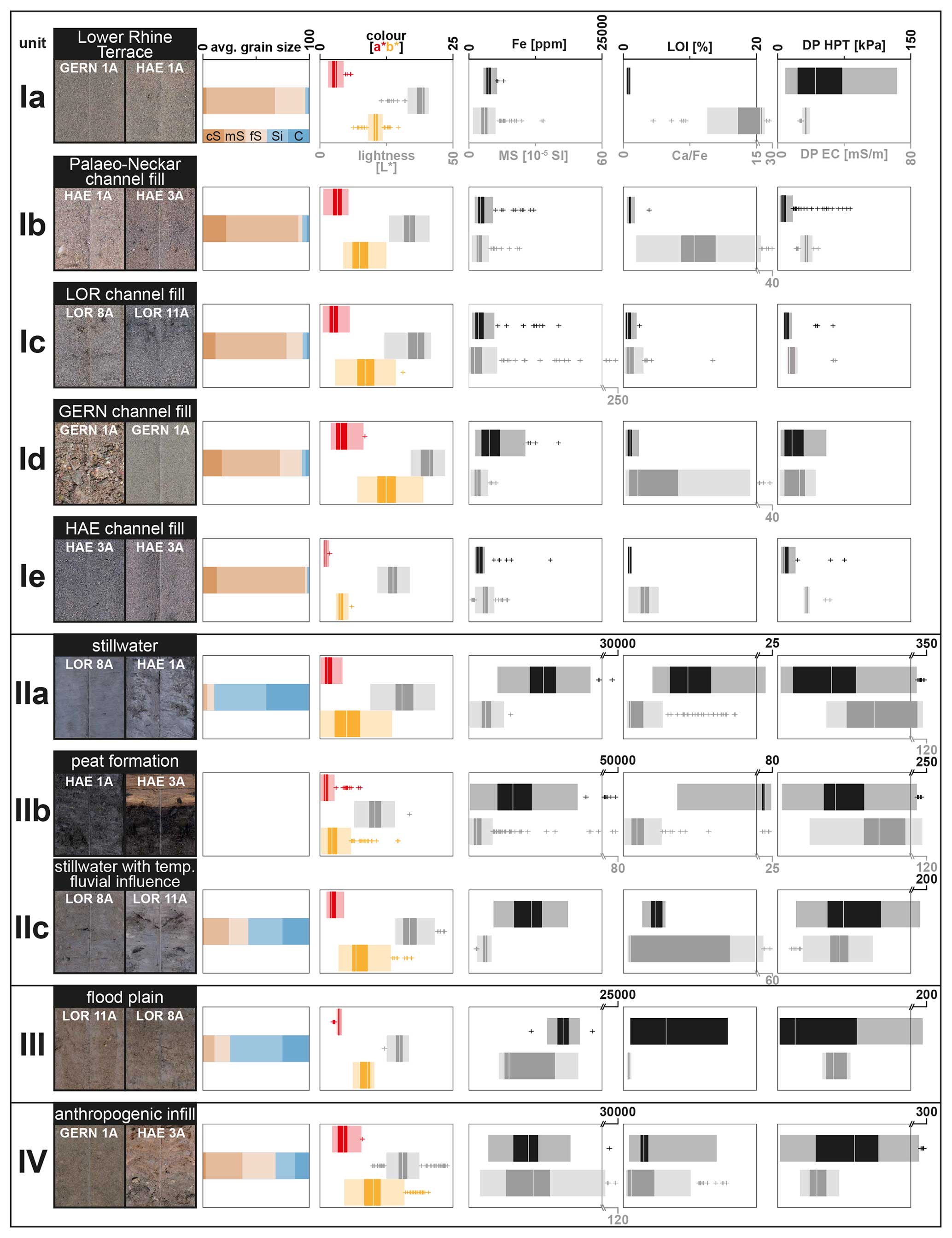
Figure 3Main sedimentary units and facies determined for sediment cores collected from the southern Hessische Ried showing representative sections of core photos, average grain size distribution (cS: coarse sand; mS: medium sand; fS: fine sand; Si: silt; C: clay), and box plots of selected geochemical and geophysical results.
More detailed information on the palaeoenvironmental proxies collected from each DP and coring site is depicted in Figs. 5, 7 and 10.
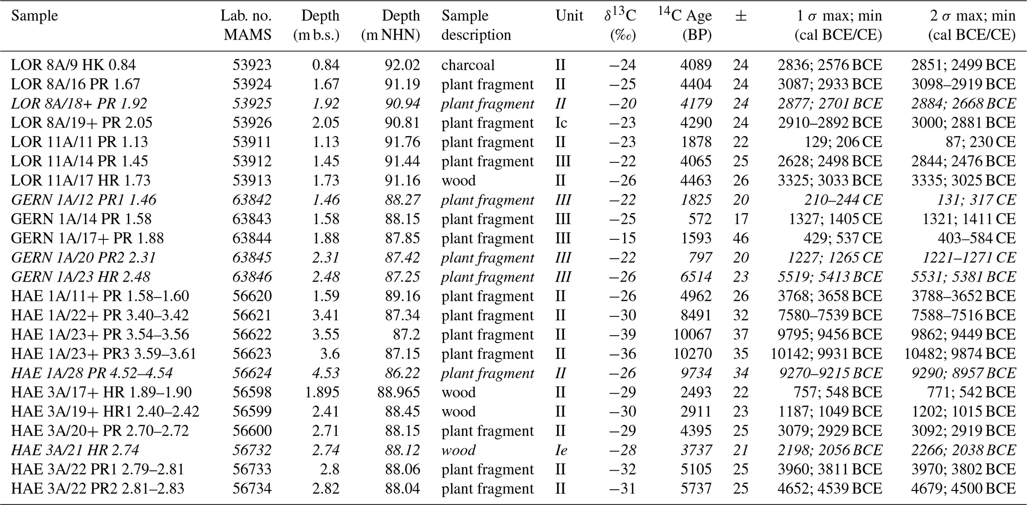
In Table 1, results of AMS radiocarbon dating of 23 samples are summarised. Further, 2σ-calibrated ages are given in their stratigraphic context in Figs. 5, 7 and 10. We exclude the results of six samples from further interpretation due to age inversions most possibly due to contamination by root penetration or reworking effects. See subsections for further explanation.
Table 1AMS radiocarbon analysis data with calibrated ages and unit affiliations. Sample with names printed in italics are not considered for interpretation due to age inversion (see text). A semicolon (;) separates the minimum and maximum calibrated ages in the case of multiple intersections of the age model with the calibration curve.
4.1 Lorsch (LOR)
The LOR study area is located northeast of the city of Lorsch and immediately east of the river Weschnitz close to the Wattenheimer Brücke (Fig. 4). The DEM shows the straightened, partly renatured Weschnitz (see Sect. 2.3.5) breaking through parabolic dunes and heading westward towards the river Rhine. In this area, the Palaeo-Neckar channel system is characterised by numerous meanders, most of which are influenced and modified by the Lauter alluvial fan and by numerous younger Weschnitz channels. The deepest depression in the LOR study area is called Wolfslache and runs parallel to the Neuer Graben, which flows straight and is dyked into the river Weschnitz near the Wattenheimer Brücke. We recovered sediment cores LOR 8A and LOR 11A with a length of 3 m each from the Wolfslache and Im Horst, respectively (Figs. 1 and 4).
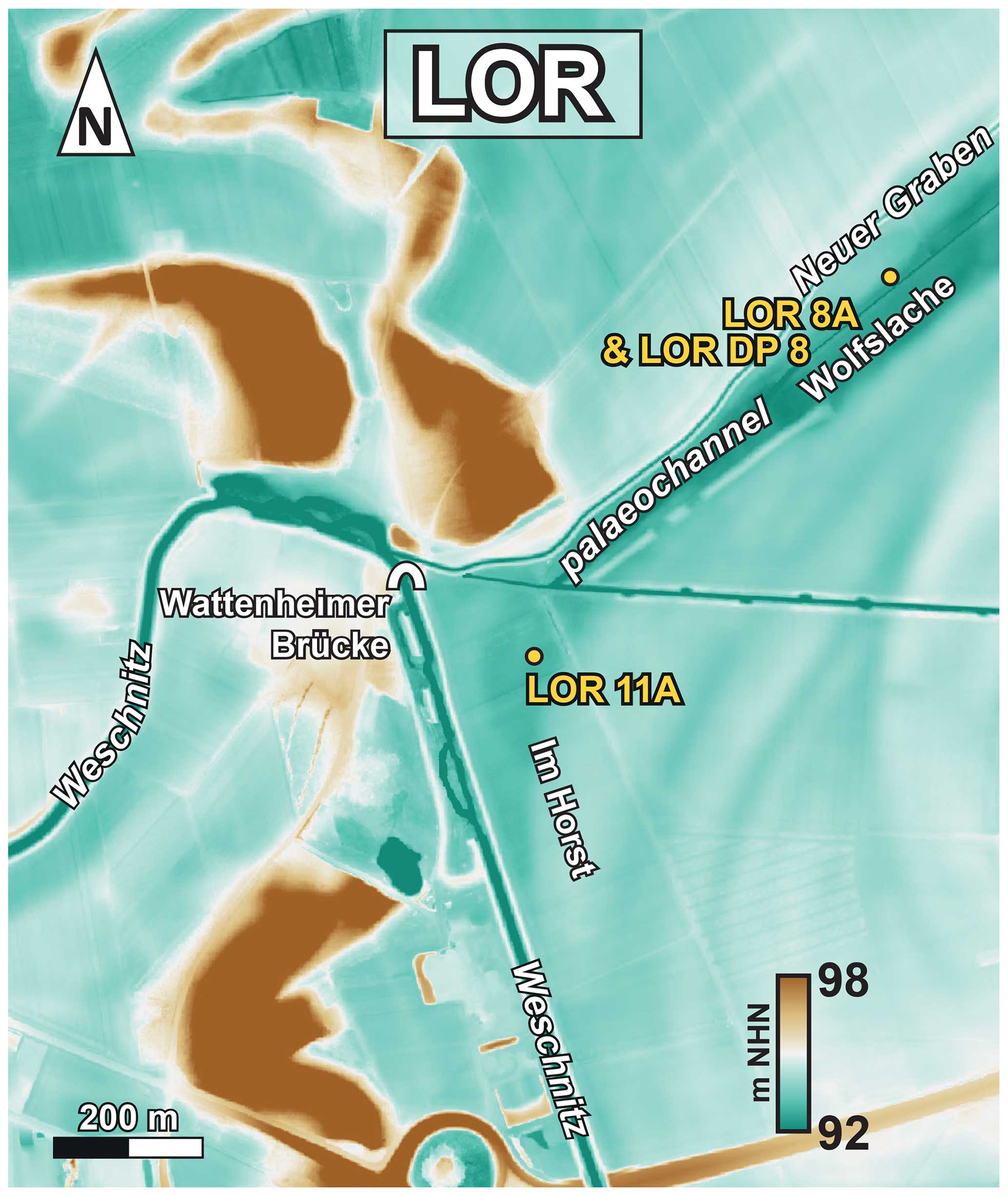
Figure 4DEM of the study area near Lorsch (LOR) with the location of sediment cores showing the Weschnitz knee leading the river in a westward direction across a belt of dunes. A former Weschnitz palaeochannel is called Wolfslache. DEM source: HVBG (2023).
Sediment cores LOR 8A and LOR 11A show fluvial medium sands of subunit Ic at their base. These sands are characterised by a low ratio ranging between 0.2 and 3.2. In core LOR 11A, the section between 2.62 and 2.30 m below surface (b.s.) shows a remarkably high iron content, accompanied by high MS and brightness values. In both cores, basal fluvial sands are followed by silt- to clay-dominated sediments of unit II in which a thin layer of subunit Ic fluvial sands is embedded. Also, fine and medium sands are marginally present. The ratio of unit III is generally low, with the exception of a striking peak in sediment core LOR 8A with a maximum of 12.6. The uppermost sedimentary unit III is characterised by silt-dominated floodplain sediments. In sediment core LOR 11A, however, unit IV sands are found between 0.70 and 0.41 m b.s. This layer has a high ratio up to 11.6 and particularly high L*, a* and b* values strongly differing from the basal sands of subunit Ic. In February 2021, the groundwater table was at 1.25 m b.s. at coring site LOR DP 8 (Fig. 5b). Calibrated radiocarbon ages for the study area of LOR reveal that the basal fluvial main phase (subunit Ic) ends shortly after 3335 and 3025 cal BCE (core LOR 11A) and at 3000–2881 cal BCE (LOR 8A), namely around 3000 cal BCE. The thin subunit Ic layer intersecting unit II muds represents a temporary reactivation of fluvial dynamics between 2844–2476 cal BCE and 3098–2919 cal BCE found for core LOR 11A and core LOR 8A, respectively (Fig. 5); it thus seems that this short reactivation did not occur later than 2900 cal BCE.
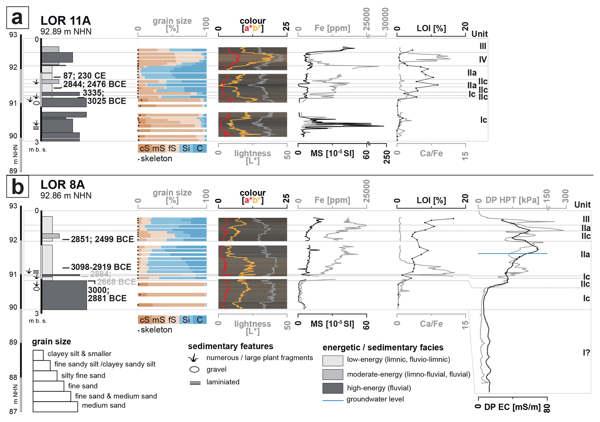
Figure 5Stratigraphy of sediment cores LOR 11A and LOR 8A with calibrated radiocarbon ages (2σ; radiocarbon ages in grey are not considered for interpretation), grain size and colour data, MS and Fe values, LOI and ratio, and DP HPT and DP EC data. Our data show that the Weschnitz river channel (subunit Ic) was no longer active after ca. 3000 cal BCE at both coring sites.
4.2 Gernsheim (GERN)
The GERN study area is located to the south of the town Gernsheim. Here, the modern Winkelbach, dyked and rectified, was shifted by 90° from its original channel into a human-made canal (Fig. 6). The DEM shows a ca. 15 m wide meandering depression accompanied by rectangular structures, so-called Ackerberge (farmland mounds; see e.g. Sabel and Dambeck, 2005; Stolz et al., 2012). ERT data suggest a single palaeochannel structure for the depression. Sediment core GERN 1A was recovered from the southernmost meander of the palaeo-Winkelbach down to a depth of 6 m b.s. (Fig. 6).
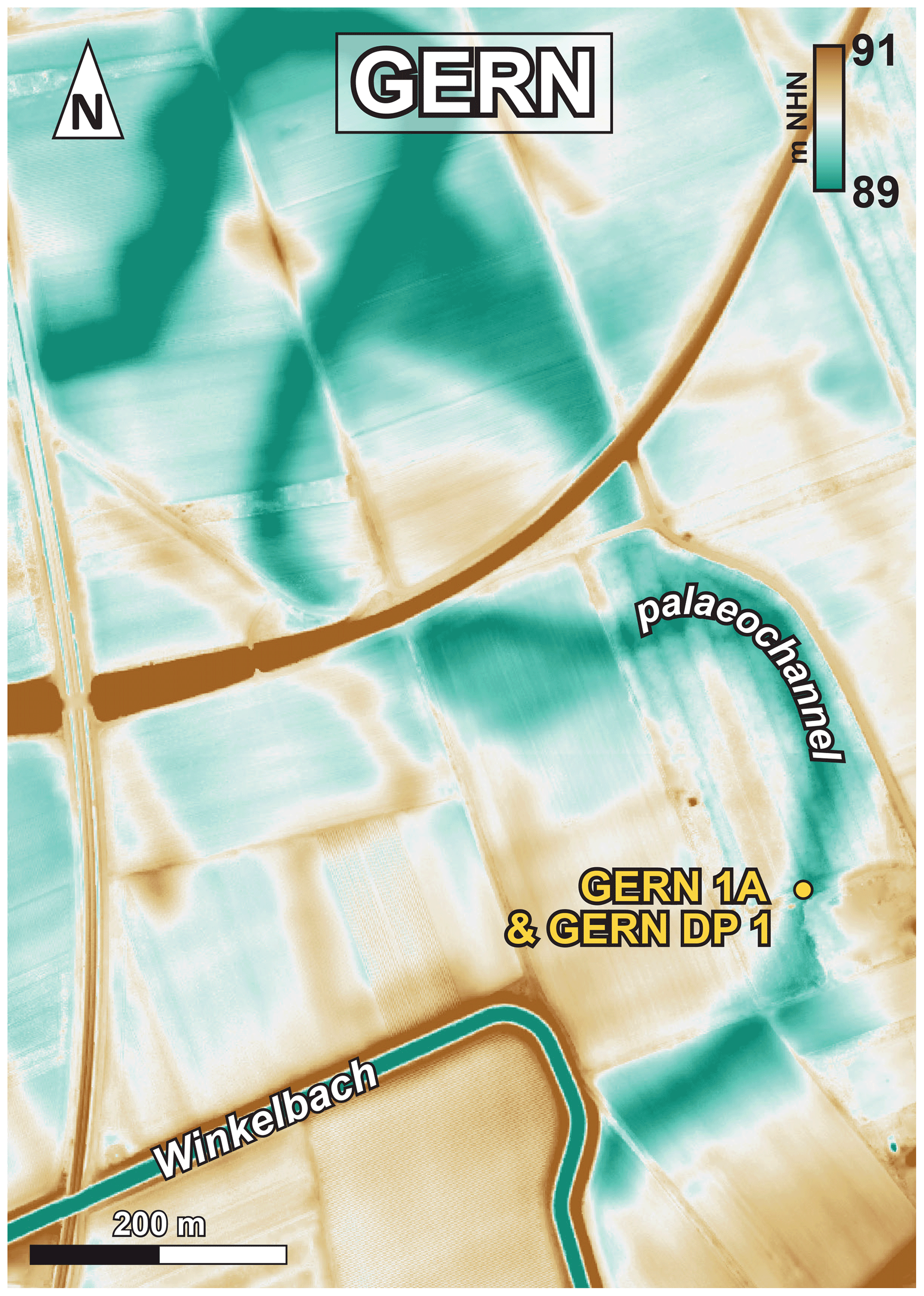
Figure 6DEM of the study area near Gernsheim (GERN) with coring site GERN 1A showing a palaeochannel leaving today's course of the Winkelbach to the northeast. DEM source: HVBG 2023.
At the base of sediment core GERN 1A, homogeneous Lower Rhine Terrace sands of subunit Ia were found. On top, we found sediments of the heterogeneous channel fill subunit Id, showing sections of both well-sorted medium sands and poorly rounded gravel in a sandy matrix. From 2.53 m b.s. upwards, unit III floodplain sediments dominate and include a 13 cm thick intersected subunit Id layer. Between 2.33 m and 1.86 m b.s., the ratio and L* value are exceptionally high. The uppermost section represents infill of unit IV material, including ceramic fragments. The groundwater table determined with the HPT system in February 2023 was at 3.64 m b.s.
The radiocarbon chronology obtained for sediment core GERN 1A contains several age inversions due to reworking effects. Nevertheless, our results show that the Winkelbach palaeomeander was still active in early modern times (after 1321–1411 cal CE). Channel dynamics are also evident for late Roman/early Medieval times (403–548 cal CE; Table 1, Fig. 7). Thick subunit Id sediments found on top of Lower Rhine Terrace sands therefore must have been deposited during Roman times or earlier.
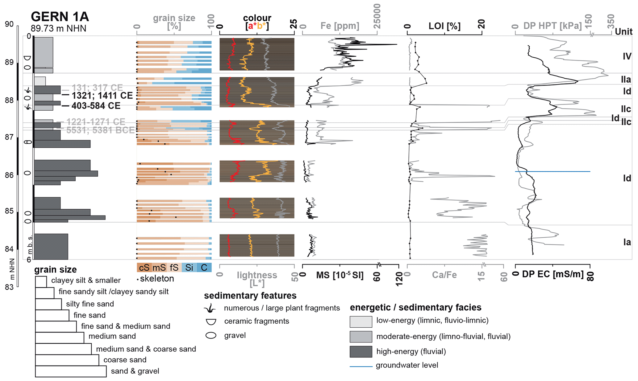
Figure 7Stratigraphy of sediment core GERN 1A with calibrated radiocarbon ages (2σ; radiocarbon ages in grey are not considered for interpretation), grain size and colour data, paired MS and Fe values, LOI and ratio, and DP HPT and DP EC data. Our data show that channel fill sands of subunit Id continue being deposited at least until ca. 1400 CE.
4.3 Hähnlein (HAE)
The HAE study area is located north of the village of Hähnlein and spans the entire width of the Palaeo-Neckar depression, which here is ca. 220 m wide. Within this depression, a ca. 25 m wide palaeochannel can be detected based on DEM data (Fig. 8). Additionally, a straight drainage ditch, also called Landgraben (Modau–Landgraben), flows parallel to the left bank of the Palaeo-Neckar depression (Fig. 8).
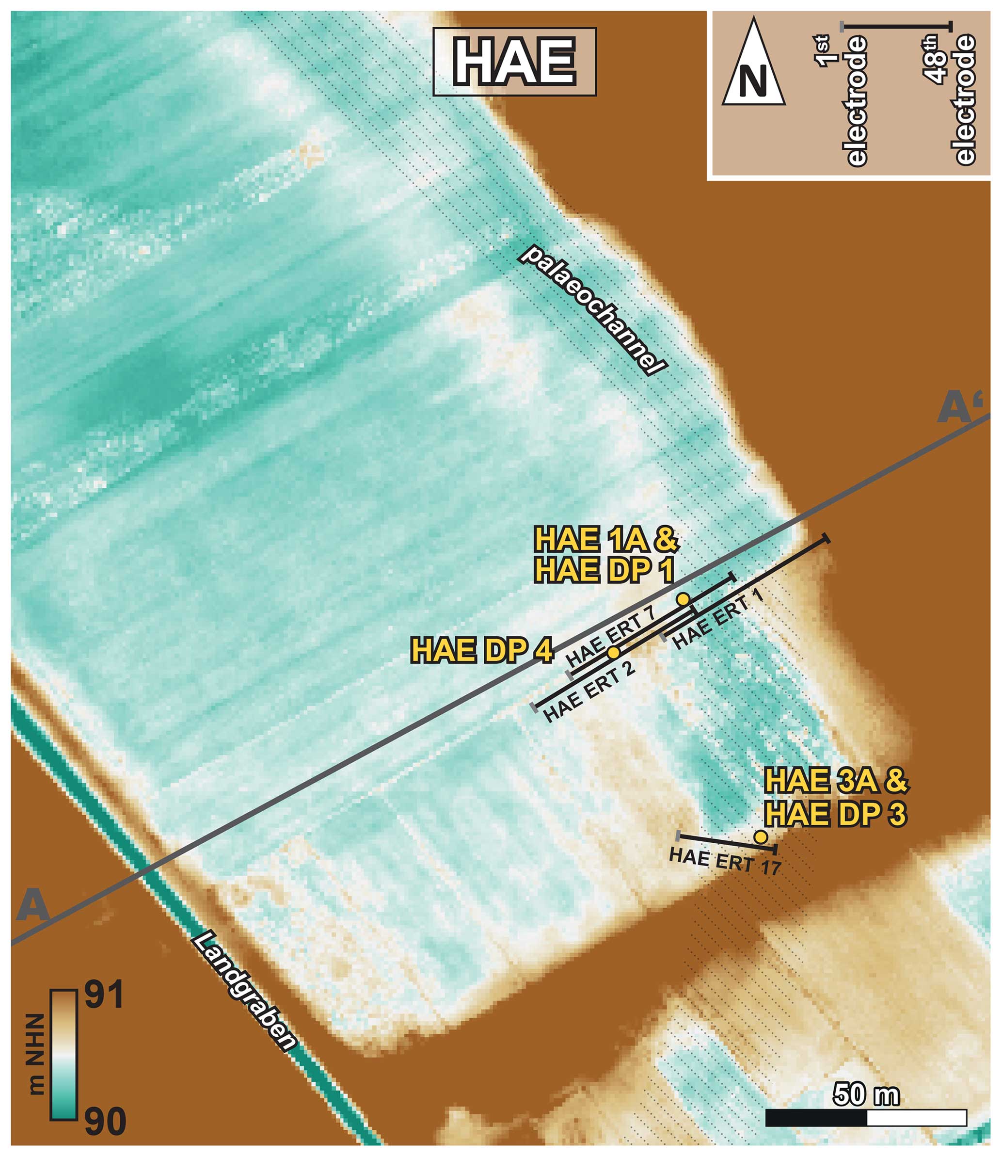
Figure 8DEM of the study area near Hähnlein (HAE) with the location of ERT transects, DP measurements and coring sites. A–A' marks the cross section depicted in Fig. 13. A small palaeochannel at the eastern fringe of the Palaeo-Neckar depression is discernible. DEM source: HVBG 2023.
The merged ERT transects HAE ERT 2, 7 and 1 represent a cross section through the eastern half of the Palaeo-Neckar depression covering the entire palaeochannel structure mentioned above (Fig. 8). ERT transects HAE ERT 6 and 17 focus on the western fringe of this channel (Fig. 8). All ERT transects show a zone of relatively high resistivity (> 46 Ωm) below a zone of lower resistivity (< 46 Ωm). The transition between these two zones clearly descends to the east. The coring site HAE 1A is situated where the low-resistivity zone is thickest. In contrast, the site HAE DP 4 is located where the low-resistivity zone is thinnest (Fig. 9). Site HAE 3A lies at the centre of the small palaeochannel visible in the DEM (Fig. 8). High-resolution DP EC data of HAE DP 4, 1 and 3 generally corroborate the results of ERT measurements but yield more detailed information on the vertical variability of the electrical resistivity as depicted in ERT depth sections.
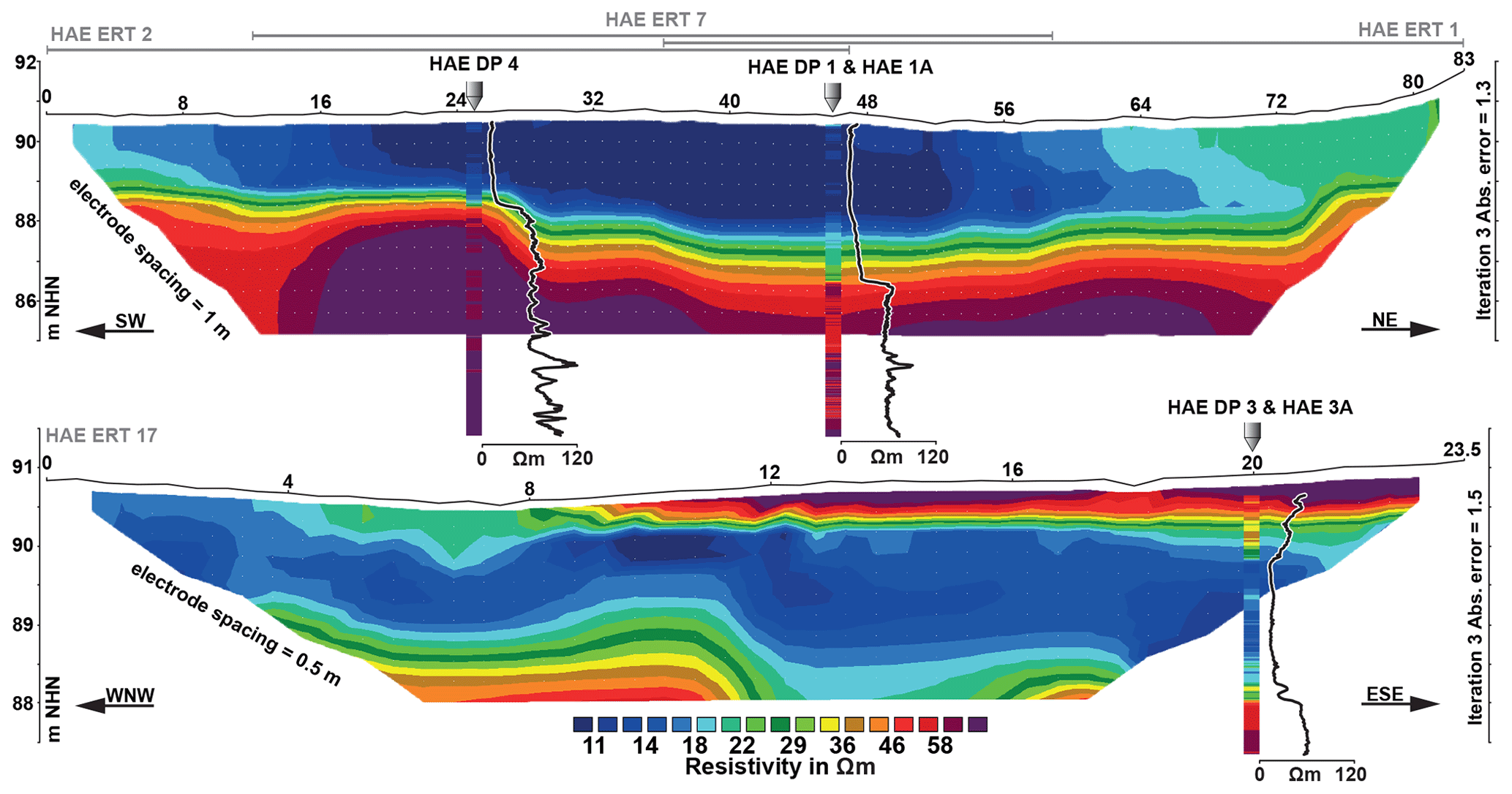
Figure 9Depth sections for selected ERT transects combined with results of DP EC measurements. For locations of ERT transects and coring sites, see Fig. 8.
Sediment core HAE 1A reaches a depth of 8 m and shows homogenous Lower Rhine Terrace medium sand (Ia) at its base followed by Palaeo-Neckar sand with higher portions of coarse sand and skeleton (Ib). Unit II mainly consists of silt at its base (subunit IIa) and is represented by peat (IIb) between 3.61 and 1.55 m b.s., which is then covered by silty clay (IIa) again. Within subunits IIa and IIb, iron concentrations are increased. Upcore, we found poorly sorted anthropogenic infill (unit IV) (Fig. 10a).
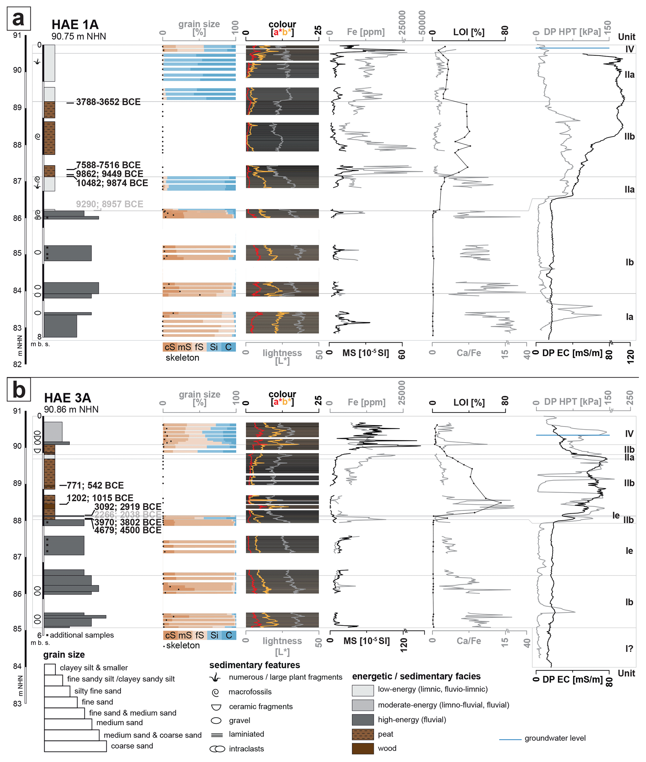
Figure 10Stratigraphy of sediment cores HAE 1A and HAE 3A with the location of additional samples, calibrated radiocarbon ages (2σ; radiocarbon ages in grey are not considered for interpretation), grain size and colour data, MS and Fe values, LOI and ratio, and DP HPT and DP EC data. Our data show that channel fill sands of subunit Ib and of subunit Ie stopped being deposited after ca. 10 000 cal BCE at site HAE 1A and after ca. 3000 cal BCE at site HAE 3A.
At site HAE 3A, the basal facies is represented by Palaeo-Neckar sands (subunit Ib). From 4.36 m b.s. upwards, we encountered very homogenous grey sands (subunit Ie). With a very sharp contact at 2.83 m b.s., subsequent peat formation (subunit IIb) starts and is only interrupted by a thin subunit Ie sand layer at 2.72–2.75 m b.s. Subunit IIb peat continues up to 1.00 m b.s., with its mineral content increasing towards the top. Thick and poorly sorted infill with ceramic fragments (unit IV) was found on top. In February 2022, the groundwater was encountered at 0.20 m b.s. at site HAE DP 1 and at 0.52 m b.s. at site HAE DP 3 (Fig. 10b).
Calibrated AMS radiocarbon ages for the basal peat in sediment core HAE 1A show that sediments of unit I were no longer deposited after 10 482–9874 cal BCE, when peat formation in the Palaeo-Neckar depression began. At site HAE 1A, peat growth continued until around 3788–3652 cal BCE. At coring site HAE 3A, in contrast, unit I sediments were covered by sands of subunit Ie until 3092–2919 cal BCE, when peat formation became dominant. At site HAE 3A, peat growth continues at least until 771–542 BCE (Fig. 10).
Grain size data show that both subunits Ib and Ie are well sorted; however, subunit Ie is sorted to a much higher degree because subunit Ib sands also contain considerable portions of coarse sand and also of silt and clay fractions (Fig. 11). In contrast, subunit Ie almost completely consists of medium sand.
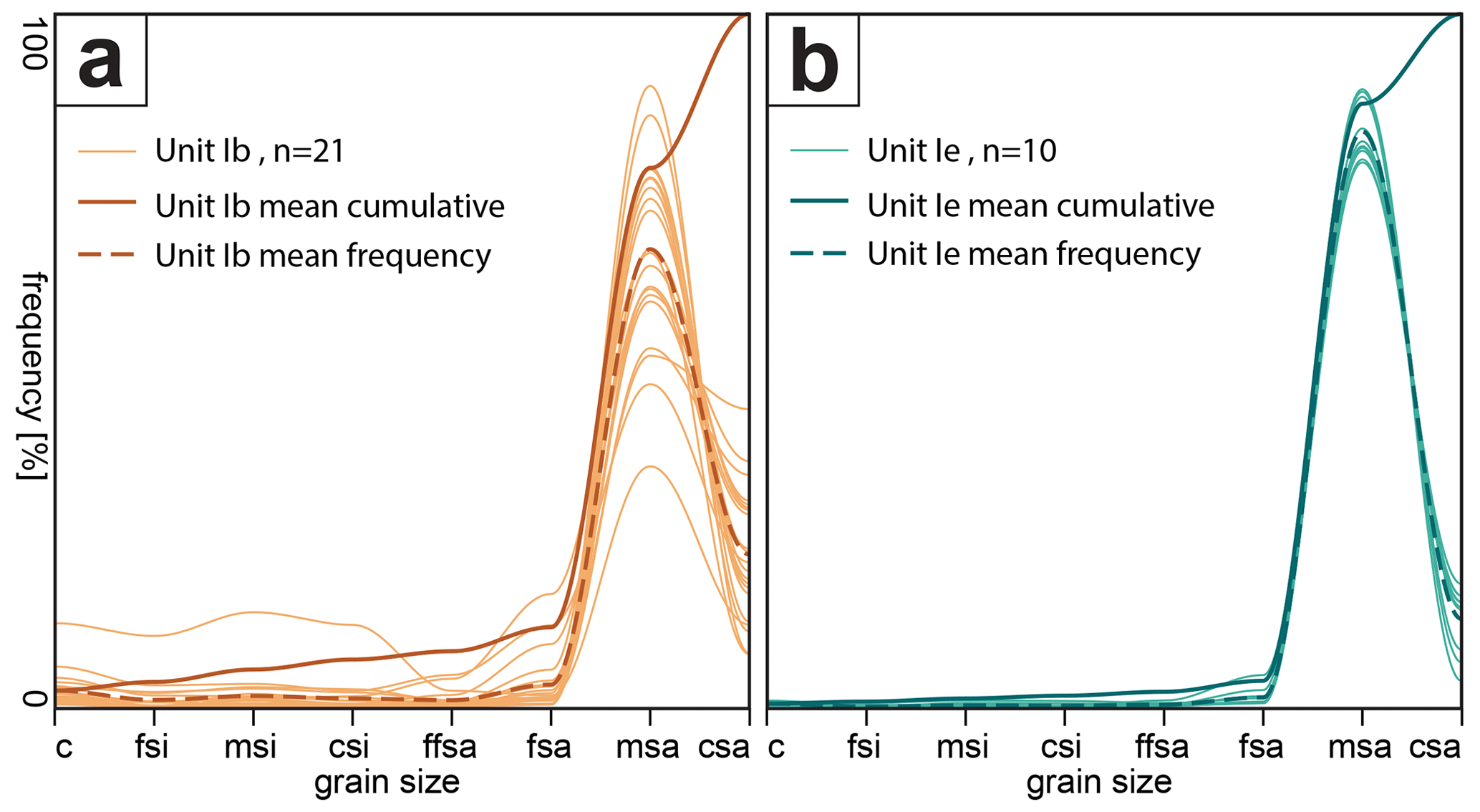
Figure 11Mean grain size data found for sedimentary subunits Ib (a) and Ie (b) based on samples from sediment cores HAE 1A and 3A, respectively.
In order to differentiate between subunit Ib and subunit Ie, we carried out detailed geochemical and spectrophotometric analyses based on samples collected from sediment cores HAE 1A and 3A. For sampling depths, see Fig. 10. Subunit Ib samples are characterised by higher CaO, TiO2, Al2O3 and CaCO3 contents compared to any samples from subunit Ie. Only the SiO content is partly higher in subunit Ie compared to subunit Ib (Fig. 12a, b and e). In addition, XRF measurements of Sr, Zr, Ca and Si revealed a much higher spectrum of concentrations for subunit Ib than for subunit Ie. Generally, medium to maximum values are always found for subunit Ib sands. The strongest differences were found for Ca: high concentrations are restricted to subunit Ib material, while subunit Ie sands only show minimum concentrations (Fig. 12c and d). The subunits Ib and Ie also strongly differ in terms of colour. a* and b* values show a lower spread in subunit Ie and are significantly lower than those of subunit Ib, which results in a more greyish colour (Fig. 12f).
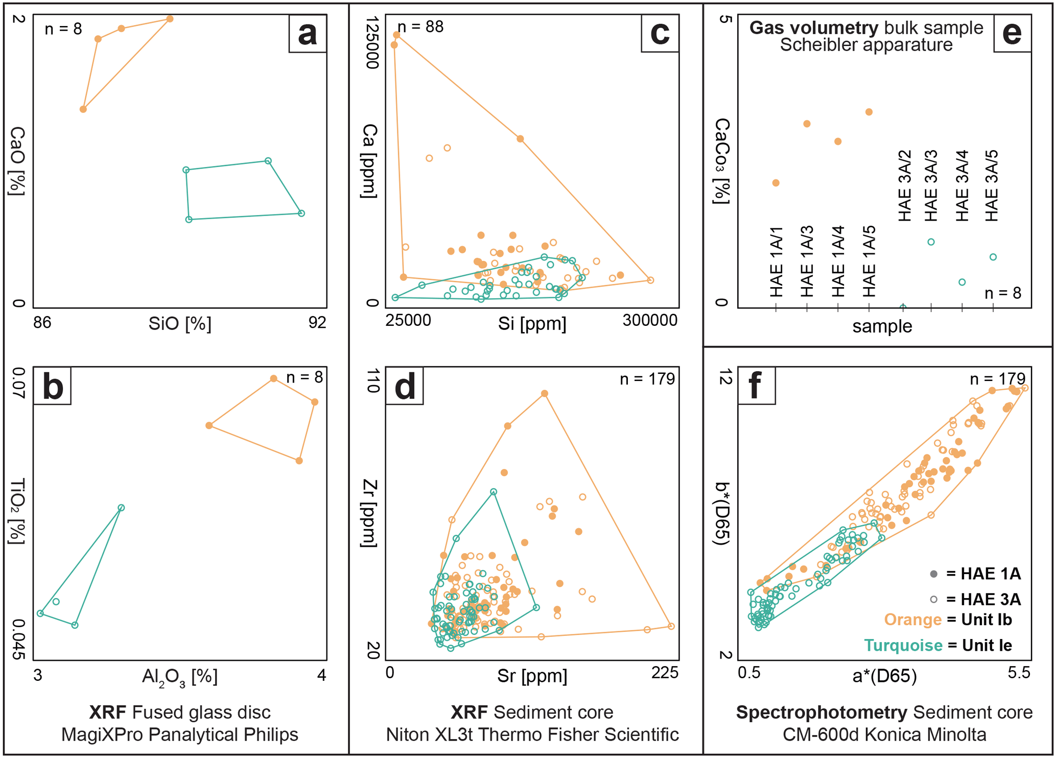
Figure 12Geochemical and geophysical properties of sediment samples from subunits Ib and Ie retrieved from sediment cores HAE 1A and HAE 3A.
5.1 Spatio-temporal reconstruction of the Weschnitz fluvial system
According to Bos et al. (2008, 70 ff.) the river Neckar palaeochannel system was used by the river Neckar itself until the transition between the Younger Dryas and the Preboreal (see also Dambeck and Bos, 2002; Dambeck and Thiemeyer, 2002; Dambeck, 2005; Engel et al., 2022). At Wasserbiblos near Riedstadt-Crumstadt, siltation of a former Neckar meander started shortly before ca. 11.1 to 10.2 ka cal BP (9.1–8.3 cal BCE), and at Großes Bruch near Groß-Gerau, the Palaeo-Neckar bed started to silt up between 10.5 and 10.3 ka cal BP (8.5–8.3 cal BCE; Bos et al., 2008: Table 1). By this time, the river Neckar had already shortened its course and continued to run directly westward from Heidelberg to the area of its present confluence with the river Rhine near Mannheim. The Palaeo-Neckar channel was subsequently filled up with mineral deposits and peat (Sauer, 1892; Herzberg, 1962; HLNUG, 2011). Detailed geoarchaeological studies in the environs of the Roman burgus near Trebur-Astheim revealed that the Lower Terrace sands of the river Rhine system in the northern Hessische Ried seem to have been deposited at least until the 10th millennium cal BCE (Appel et al., 2024). This is quasi-contemporaneous with the abandonment of the nearby Palaeo-Neckar channel (Bos et al., 2008; see above) at the transition between the Younger Dryas and the Preboreal.
The fluvial sands of subunit Ic encountered at coring sites LOR 8A and LOR 11A were dated much younger, namely to the time before ca. 3000 cal BCE. Moreover, they are restricted to a small palaeochannel inside the wide Palaeo-Neckar bed, so they cannot have been deposited by the river Neckar itself but rather by the river Weschnitz before it broke through the dunes in a western direction and created the present river knee (Fig. 4). Sediment cores LOR 8A and LOR 11A therefore confirm (i) continued fluvial activity by the Weschnitz river within the abandoned Palaeo-Neckar riverbed after ca. 10 000 cal BCE and (ii) a former northward flow direction of the river Weschnitz until its diversion around 3000 cal BCE.
At coring site LOR 11A the Weschnitz sediment shows laminae, banding and generally more variance in geochemical and geophysical measurement results, whereas the fluvial sands at site LOR 8A appear more homogenous (Fig. 5). The final fluvial channel activity stops quasi-simultaneously at both coring sites with the onset of siltation around ca. 3000 cal BCE, meaning that the river Weschnitz then left its north-facing bed and turned westwards across the dune belt.
The palaeo-Weschnitz that flowed within the Palaeo-Neckar system in a northern direction connected the study areas of Lorsch and Hähnlein. At Hähnlein, we found fluvial channel deposits at coring sites HAE 1A and HAE 3A. However, they differ in elevation, thickness, colour, sediment texture, and age and thus can be assigned to different river generations. Differences in sediment geochemistry at study site Hähnlein between subunit Ia, subunit Ib and subunit Ie can be directly assigned to different catchment areas. We found that the ratio works well to distinguish subunit Ib from subunit Ie. These differences can be directly traced back to the fact that the Neckar catchment with its dominating Mesozoic and Quaternary sedimentary rocks such as Muschelkalk, Gipskeuper, marl, or loess (LGRB, 2021) is in strong contrast to the Weschnitz catchment, which is made out of granites, granodiorites, gneiss and other rocks rich in amphibole of the crystalline Odenwald (Amstutz et al., 1975; Will et al., 2021; HLNUG, 2024b). XRF measurements on fused glass discs as well as gas volumetry results (for sampling depth see Fig. 10) corroborate these clearly distinguishable sources of fluvial sediments found at Hähnlein, namely high concentrations of Ca and CaCO3 for subunit Ib Palaeo-Neckar samples and high Si concentrations for subunit Ie palaeo-Weschnitz samples (Fig. 12c and e). Also, the difference in concentrations of Ti and Al, both resistant to weathering (Kabata-Pendias, 2011; Rothwell and Croudace, 2015), between subunit Ib and subunit Ie clearly denotes differing provenance areas. Regarding Zr and Sr, Fig. 12d shows that the spectrum of concentrations found for subunit Ib samples strongly exceeds the spectrum found for subunit Ie samples. This is because the catchment of the entire Neckar system also comprises crystalline rocks from the eastern Schwarzwald (also known the Black Forest) but is otherwise dominated by Mesozoic sedimentary rocks, while subunit Ie just represents the condensed crystalline Odenwald spectrum of the much smaller Weschnitz catchment. We further assume that the colour spectrometric differences between subunit Ib and subunit Ie (Fig. 12f) are not caused by post-sedimentary processes but rather reflect differences in source material. Finally, differences in grain size distribution document differences in the flow regime. Whereas Palaeo-Neckar subunit Ib sediments also comprise gravel and coarse sand indicating a larger flow variability and higher flow velocities, subunit Ie is almost perfectly sorted and exclusively made out of medium sand (Figs. 10 and 11). We thus conclude that river channel subunits Ib and Ie were nourished by rivers from strongly differing catchments, namely the wider Palaeo-Neckar catchment and the Weschnitz catchment, respectively.
The river Weschnitz fluvial activity (subunit Ie) at Hähnlein finally stopped at ca. 3000 cal BCE (3092–2919 cal BCE, Fig. 10), which corresponds to the cessation of the Weschnitz activity found for the Lorsch site LOR 8A (3000–2881 cal BCE, Fig. 5). Geomorphological studies at Lorsch and Hähnlein therefore prove for the first time that the river Weschnitz finally left its original channel in the Palaeo-Neckar system as early as around 3000 cal BCE. This means that the present course of the river Weschnitz directly to the west and crossing the dune field near the Wattenheimer Brücke seems to have been active since ca. 3000 cal BCE.
Based on DEM, ERT and DP prospection in conjunction with sedimentary and stratigraphic data, we were able to draw a schematic cross section of the Palaeo-Neckar depression at Hähnlein (Fig. 13). The basal boundary of the palaeo-Weschnitz channel fill sediment lies at 86.5 m NHN and the upper boundary lies at 88.1 m NHN. The basal boundary of the Palaeo-Neckar channel fill sediment for location HAE 1A lies at 83.9 m NHN and the upper boundary lies at 86.2 m NHN. ERT transects HAE ERT 2, 7 and 1 show that the latest Palaeo-Neckar channel within the depression is ca. 80 m wide and has its cut bank at the right edge of the Palaeo-Neckar depression. The location of the smaller palaeo-Weschnitz channel becomes visible in the DEM and is detectable in ERT transects HAE ERT 2, 7 and 1 as the elevated boundary between the high-resistivity zone and the low-resistivity zone. The palaeo-Weschnitz obviously did not incise into the Palaeo-Neckar sands but into stillwater sediments that accumulated in the Palaeo-Neckar depression after the river Neckar diversion that occurred in the 10th millennium BCE. We suggest that with the increased sinuosity of the palaeo-Weschnitz meander flowing in the oversized Palaeo-Neckar depression with low flow velocities, the palaeo-Weschnitz was not strong enough to erode Palaeo-Neckar sands and that river channel activity on the one hand and siltation of the large remaining Palaeo-Neckar depression on the other hand took place simultaneously.
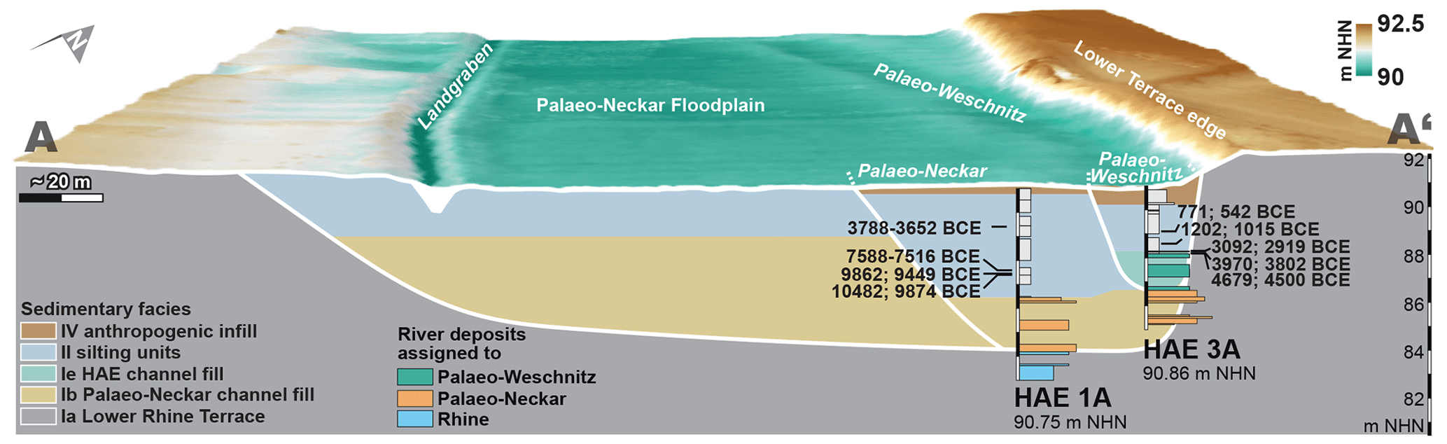
Figure 13Schematic cross section of the Hähnlein study area including DEM, DP, ERT and sediment core data (for location of cross section see Fig. 8). The Palaeo-Neckar stopped using the river channel around 10 000 cal BCE, whereas the river Weschnitz continued flowing northward and passing Hähnlein until 3000 cal BCE. DEM source: HVBG 2023.
After ca. 3000 cal BCE, there is a complete lack of river channel activity at sites HAE 1A and HAE 3A. In contrast, at site LOR 11A – close to the present Weschnitz course – we found evidence of temporary fluvial influence during Roman times (Fig. 5a). We assume that the sand layer found in the uppermost part of core LOR 11A represents artificial infill following clay extraction for the production of bricks and tiles. It is locally restricted to small strips that can be seen as vegetational anomalies in aerial photographs. Ziegeleien (brickyards) existed in the neighbouring towns of Lorsch and Biblis at least around the turn of the 18th century (Haass, 1795; Supp, 1820). The infilled sand shows clear differences in colour and geochemistry compared to subunit Ic. The Wolfslache around coring site LOR 8A rapidly silted up with sediments after it was abandoned by the river Weschnitz at ca. 3000 cal BCE. A conspicuous sand layer at site LOR 8A at ca. 1 m b.s. may reflect a temporary diversion of Lauter/Winkelbach water towards the Wattenheimer Brücke starting at the Rinnentorturm in the city of Bensheim (see Sect. 2.3.4).
The diversion of the Weschnitz to the west around 3000 cal BCE is corroborated by archaeological findings in the environs of the Wattenheimer Brücke (Figs. 1 and 4). In addition to Neolithic ceramic finds, wooden posts were uncovered during modern renaturation measures in 1999 and 2007 immediately west of the Wattenheimer Brücke and are interpreted as part of human-made construction measures to cross an E–W running water course of considerable width (Helfert, 2014). The oldest posts revealed dendrochronological and radiocarbon ages of ca. 3600, 3000, 2800 and 1700 BCE (Hartnagel et al., 2014; Helfert, 2014), implying that, in the absence of any other water courses, it was the river Weschnitz that must have followed this western course during these early times. The fact that the oldest post, dendrochronologically dated to 3578 BCE, is several hundred years older than the Weschnitz diversion based on geomorphological evidence presented in this study is interpreted as being related to the use of old wood for early constructions measures from ca. 3000 cal BCE onwards.
Still, the hypothesis that the river Weschnitz was only diverted during Roman times in the fourth century CE in order to produce a shortcut towards the river Rhine (Eckoldt, 1980, 1985) can be considered falsified based on geomorphological and geoarchaeological evidence. When the Romans arrived at the area of the Wattenheimer Brücke, the Weschnitz had already flowed westwards for almost 3 millennia as was already hypothesised by Helfert (2014, 104). Also, the idea that the river Weschnitz was diverted way after Roman times, namely in the 17th century CE as suggested by Siemers (2002), does not agree at all with our results.
5.2 Spatio-temporal reconstruction of the Winkelbach fluvial system
The base of sediment core GERN 1A is made out of Lower Rhine Terrace sands (subunit Ia) which appear similar to those encountered at site HAE 1A (Fig. 14). On top, we found badly sorted sand including abundant pieces of poorly rounded gravel (subunit Id). The latter does not seem transported by the river Rhine but rather transported for only a short distance from the Odenwald Mountains by the Winkelbach itself during an early phase of vivid fluvial activity that may be interpreted as high-energy discharge bound to extreme rainfall and/or runoff events. This channel generation seems to represent the first appearance of the Winkelbach flowing directly towards the Rhine after having crossed the Palaeo-Neckar depression, which had been abandoned by the Neckar at ca. 10 000 cal BCE. The palaeomeander visible in the DEM (Fig. 6) must have developed during a subsequent phase of more reduced but stable flow velocity as evidenced by its well-sorted basal sands and the subsequent sequence of siltation (subunit IIc). The uppermost part of core GERN 1A is made out of infill put in place by the local farmer in order to improve arable lands.
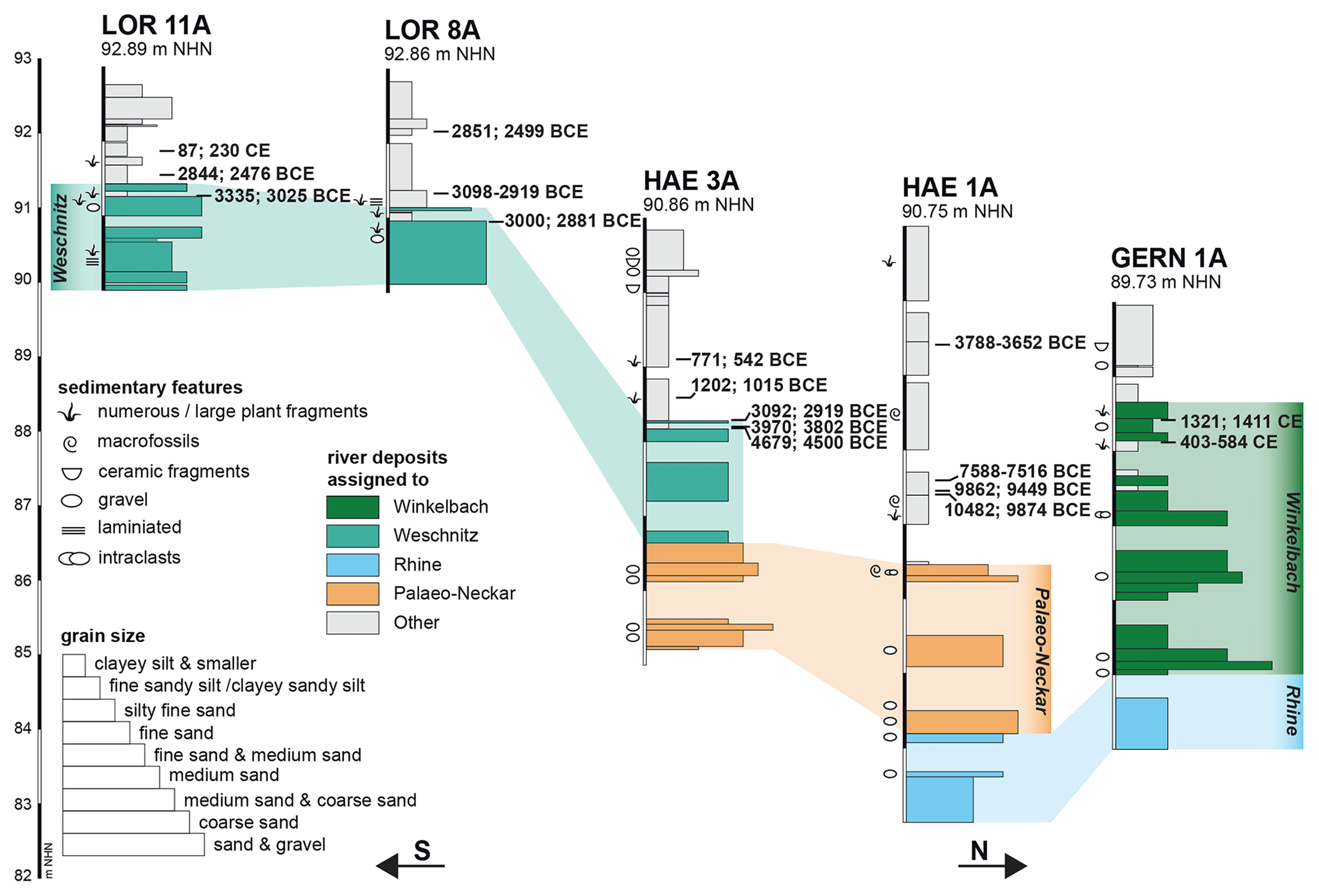
Figure 14Transect of sediment cores recovered from the southern Hessische Ried at sites Lorsch, Winkelbach/Lauter and Hähnlein with calibrated radiocarbon ages (2σ) and interpretation of the river systems. Fluvial activity at sites LOR and HAE stopped simultaneously at ca. 3000 cal BCE when the Weschnitz was diverted directly westwards at the Wattenheimer Brücke.
The majority of the collected samples yielded unreliable radiocarbon ages due to age inversions. The age of 5531–5381 cal BCE is considered reworked as, at that time, the river Weschnitz (including the Winkelbach/Lauter) still flowed northward and passed the Hähnlein site; the subsequent age of 1221–1271 cal CE is too young for this sampling depth, in contrast to two following older ages; also, the uppermost age of 131–317 cal CE is considered inverted due to reworking (Fig. 7). Based on the evaluation of the two remaining non-inverted, reliable radiocarbon ages (403–584 cal CE, 1321–1411 cal CE), the river channel of the Winkelbach encountered at site GERN 1A was still active during late Roman to early medieval times (403–584 cal CE) and kept this direction at least until late medieval times (1321–1411 cal CE) or even later as evidenced by fluvial sands dating to this time period.
Further information on the age of the diversion of the river Winkelbach/Lauter towards the river Rhine may be derived from archaeological finds of a Roman bridge across the Palaeo-Neckar depression to the west of Hartenauer Hof near Bickenbach (Fig. 1). Here, Geyer et al. (1977) excavated wooden posts of a 300 m long bridge, and Schmidt and Schwabedissen (1978; see also Becker, 1981) dated their cutting age to the year 145 CE based on dendrochronological analyses. Geyer et al. (1977) do not report on any findings of river channel sediments in conjunction with the Roman bridge near Bickenbach, so this bridge seems to have crossed the swampy Palaeo-Neckar depression rather than a (Winkelbach/Lauter) river channel. This infers that the Winkelbach/Lauter had left the Palaeo-Neckar depression at 145 CE at the latest.
As thick packages of heterogenous Winkelbach sediments are also present in the downcore sections of sediment core GERN 1A, it may be assumed that the Winkelbach has taken its direct way westwards to the river Rhine way before Roman times but still at or after ca. 3000 cal BCE, when the river Weschnitz (including the Winkelbach/Lauter) abandoned its river channel towards Hähnlein. Apart from this, the lower section of Winkelbach fluvial sediments documents at least two high-energy flood events with a subsequent return to normal discharge conditions with subunit Id being considerably more heterogeneous than other channel fill units, as already mentioned above. Since we did not find any fluvial channel deposits at Hähnlein for the time after ca. 3000 BCE, it seems unlikely that the formation of the knees of the rivers Weschnitz and Winkelbach occurred at different times. If these rivers left the Palaeo-Neckar bed at the same time, this would, however, imply a major flood event potentially related to heavy rainfall events and/or related to the melting of snow in the northwestern Odenwald Mountains. The very base of the Winkelbach channel fill at location GERN 1A represents a candidate for such a high-energy flood event and thus the initiation of knee formation. However, any supporting age determinations of this layer are so far not available (Fig. 15c).
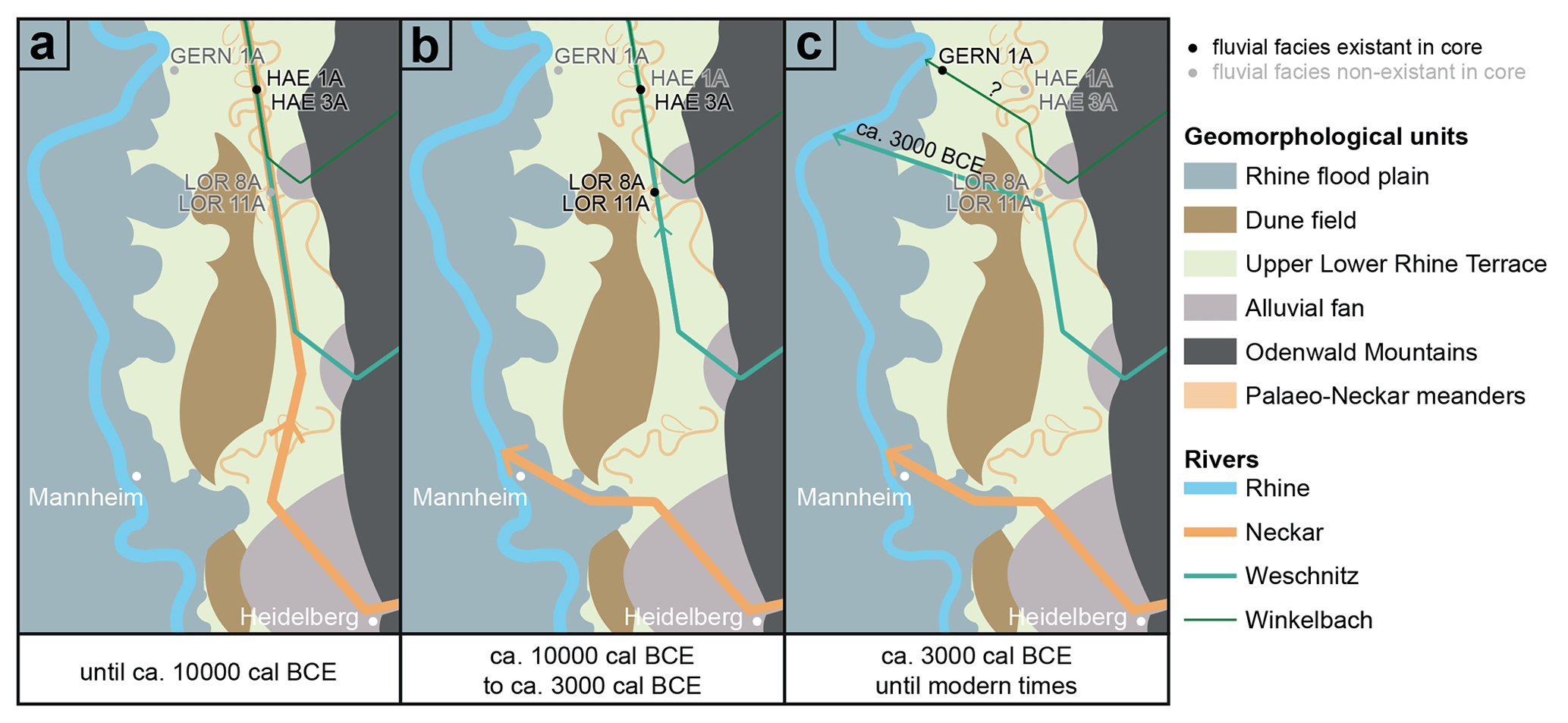
Figure 15Schematic spatio-temporal reconstruction of the fluvial evolution in the southern Hessische Ried with generalised geomorphological units and sediment core locations.
Fluvial activity at site GERN 1A finally stopped at 88.39 m NHN, when the right-angled modern Winkelbach diversion immediately southwest of the coring site was realised, probably between 1833–1836 when river regulation measures along the Winkelbach were carried out (Mangold, 1892) (Fig. 6).
5.3 Influence of the fluvial systems in the southern Hessische Ried on the navigability of the Roman Landgraben
As discussed in Sect. 5.1, the river Weschnitz had already left the Palaeo-Neckar around 3000 cal BCE by breaking through the dunes near Lorsch. Based on this, the Landgraben was not fed by Weschnitz waters during the Roman period. Also, the river Winkelbach seems to have already left the Palaeo-Neckar depression and thus the Landgraben system by 145 CE at the latest (Sect. 5.2). This means that the Landgraben of the late second century CE onwards also did not obtain water supply from the Winkelbach/Lauter. From the remaining tributaries to the Palaeo-Neckar depression towards the north, only the rivers Modau and Darmbach remain as potential feeders of the Landgraben system (Figs. 1 and 2). The Roman bridge that was excavated near Riedstadt-Goddelau (Fig. 1) is a possible indicator that the river Modau still followed the course of the Palaeo-Neckar depression during the Roman period because it is classified as a river bridge (Wagner, 1990). If so, the river Modau would have contributed its waters to the Landgraben system downstream to its confluence into the river Rhine.
It is likely that the river Darmbach was already a tributary to the Landgraben during Roman times, as it is still today. Combining the current catchment areas of both potential tributaries (145 km2 for the Landgraben/Darmbach before it flows into the river Schwarzbach and 109 km2 for the river Modau before it crosses the Palaeo-Neckar depression; HLNUG, 2022), the Roman Landgraben shows a catchment area of ca. 250 km2. The total discharge of the Darmbach in Roman times is difficult to estimate based on highly fluctuating discharge conditions due to modern wastewater management. If we assume that the discharge of the river Modau has stayed relatively stable over the past 2000 years, it would have contributed around 0.59 m3 s−1 (median daily discharge 1956–2023 at Modau monitoring station Eberstadt; HLNUG, 2024a) to the river Landgraben during Roman times. Moreover, high groundwater levels alone might even have been sufficient to make parts of the river Landgraben navigable by ship, as the groundwater level in the Hessische Ried was considerably reduced only during modern times. There is no reason to generally assume that the groundwater levels during Roman times were exceptionally lower (Büntgen et al., 2011, 2021; Tegel et al., 2020). Even shallow water depths between 0.3 and 0.7 m would have been sufficient to navigate the Landgraben with Roman barges and other keelless, flat-bottomed boats (Eckoldt, 1985; Hanel, 1995). Wettlaufer (1934, quoted from Hanel) reports that the canal bed of the bottom of the Roman Landgraben must have been at a depth of up to 4.3 m b.s. In the 1930s, wooden bank reinforcements were found along several hundreds of metres along the Landgraben (Hanel, 1995) that seem to have been built by the Romans to prevent flank collapses and rapid siltation of the waterway. Taking into account numerous findings of heavy wares at the Roman fortress Auf Esch (Wenzel, 2009), one has to assume that they were brought to the site by fluvial transport on the Landgraben. The existence of the Roman burgus at Trebur-Astheim (Appel et al., 2024) directly proves the navigability of the lower Landgraben/Schwarzbach. So far, there are no indications that the Romans undertook damming measures to temporarily heighten the discharge and thus water level of the Landgraben.
Since it is clear now that the rivers Weschnitz and Winkelbach did not contribute to the Landgraben system during Roman times, the Romans obviously managed to use multiple smaller rivers, such as the rivers Modau and Darmbach along with their even smaller tributaries, to make the Landgraben navigable.
We conducted geomorphological and geoarchaeological investigations in the southern Hessische Ried (Upper Rhine Graben, Germany) in order to reconstruct the Holocene hydrological network. The main objective was to clarify the hydrological contribution to the river Landgraben in the northern Hessische Ried along the Palaeo-Neckar depression during Roman times. This waterway was manipulated, modified, partly canalised and used for the transportation of troops and wares, as well as to ensure border security by the Romans. Based on a multi-method approach, we were able to reconstruct the Holocene development of the rivers Neckar, Weschnitz and Winkelbach/Lauter. Palaeochannel geomorphologies were detected based on DEM data, geophysical prospection by electrical resistivity tomography measurements (ERT) and direct push sensing. Sediment cores were retrieved from key sites and underwent detailed sedimentological, geochemical, mineralogical and geochronological analyses in the laboratory. We detected several palaeochannels and were able to assign them to different fluvial systems. The spatio-temporal fluvioscape of the southern Hessische Ried was reconstructed as follows.
- i.
The (Palaeo-)Neckar used to flow through the Hessische Ried until ca. 10 000 cal BCE. For the study area at Hähnlein, the width of its latest channel inside the ca. 220 m wide Palaeo-Neckar depression was reconstructed based on ERT and DP data to be ca. 80 m.
- ii.
The river Weschnitz, leaving the Odenwald Mountains at the modern city of Weinheim, used the Palaeo-Neckar depression to flow northward into the northern part of the Hessische Ried until ca. 3000 cal BCE. At that time, the river Weschnitz broke through the dunes near Lorsch, turning westward and creating the present knee, flowing directly into the river Rhine. Wooden remains of human-made construction to cross an E–W running water course in the immediate environs of the present the Weschnitz knee were dendrochronologically dated to the fourth and third millennia BCE (Hartnagel et al., 2014; Helfert, 2014), corroborating geoarchaeological results. Based on this, the diversion of the river Weschnitz was not the result of river manipulation during Roman or even later times, as speculated before. We did not find any evidence of whether the river Weschnitz diversion was initiated by man or caused by natural processes. However, based on our findings at the Winkelbach near Gernsheim, one may speculate that climatically triggered natural high-energy flood dynamics are more probable.
- iii.
The river Winkelbach/Lauter, together with the river Weschnitz, used the Palaeo-Neckar depression to flow northward. Based on geomorphological data, the river Winkelbach – similar to the river Weschnitz – later left the Palaeo-Neckar depression to cross the Lower Rhine Terrace to reach the river Rhine near Gernsheim. Our data suggest that the formation of the Winkelbach knee occurred not later than the second century CE; however, it seems more probable that this happened much earlier, namely simultaneously with the creation of the Weschnitz knee around 3000 cal BCE. Corresponding fluvial deposits let us assume that the river Winkelbach diversion was created during a high-energy flood event presumably related to strong rainfall and/or meltwater processes in the Odenwald Mountains.
- iv.
Neither the river Weschnitz nor the river Winkelbach/Lauter reached the northern Hessische Ried during Roman times. The river Landgraben was thus only fed by smaller rivers in the northern Hessische Ried, such as the river Modau and the river Darmbach. To ensure the navigability of the river Landgraben downstream to its confluence with the river Rhine near Trebur, the Romans therefore had to strictly control these rivers, collect water from smaller tributaries and guarantee the best possible efficiency of the river Landgraben by engineering measures.
The data that support the findings of this study are available from the authors upon request.
The supplement related to this article is available online at: https://doi.org/10.5194/egqsj-73-179-2024-supplement.
The concept of the study presented in this paper was developed by AV, EA and TB in the context of the interdisciplinary LandGraben project directed by TB, MS, DW and AV. Fieldwork and laboratory analyses were carried out by EA, LO, HS, PF, TW and AV. Data processing and analysis were carried out by EA. Figures and tables for this paper were created by EA. A first draft of the paper was written by EA and AV. All authors commented on and approved the paper.
The contact author has declared that none of the authors has any competing interests.
Publisher's note: Copernicus Publications remains neutral with regard to jurisdictional claims made in the text, published maps, institutional affiliations, or any other geographical representation in this paper. While Copernicus Publications makes every effort to include appropriate place names, the final responsibility lies with the authors.
This article is part of the special issue “Quaternary research in times of change – inspired by INQUA Roma 2023”. It is a result of the INQUA conference, Rome, Italy, 14–20 July 2023.
We thank Rudolf Schmitt (Georgenhof, Gernsheim) and other owners and tenants for allowing us to carry out fieldwork on their properties. We also thank Stephan Buhre, Institute of Geosciences at Johannes Gutenberg-Universität Mainz, for XRF analyses on fused glass discs.
This research has been supported by the Deutsche Forschungsgemeinschaft (DFG, project no. 491982391).
This open-access publication was funded by Johannes Gutenberg University Mainz.
This paper was edited by Julia Meister and reviewed by Thomas Roggenkamp and one anonymous referee.
Ad-hoc-Arbeitsgruppe Boden: Bodenkundliche Kartieranleitung, 5th edn., Hannover, 438 pp., 2005.
Ahner, J., Ahrends, B., Engel, F., Hansen, J., Hentschel, S., Hurling, R., Meesenburg, H., Mestemacher, U., Meyer, P., Möhring, B., Nagel, J., Pape, B., Rohde, M., Rumpf, H., Schmidt, M., Schmidt, M., Spellmann, H., and Sutmöller, J.: Waldentwicklungsszenarien für das Hessische Ried: Entscheidungsunterstützung vor dem Hintergrund sich beschleunigt ändernder Wasserhaushalts- und Klimabedingungen und den Anforderungen aus dem europäischen Schutzgebietssystem Natura 2000, edited by: Nordwestdeutsche Forstliche Versuchsanstalt, Univ.-Verl. Göttingen, Göttingen, 398 pp., https://doi.org/10.17875/gup2013-259, 2013.
Amstutz, G. C., Meisl, S., and Nickel, E. (Eds.): Mineralien und Gesteine im Odenwald. Beiträge zum heutigen Forschungsstand, 344 pp., https://epic.awi.de/id/eprint/34561/ (last access: 30 September 2024), 1975.
Anonymous: Stereographische Karte mit Ansichten von Nierstein, Oppenheim, Geinsheim, Wallerstädten, Trebur und Astheim, Staatsarchiv Darmstadt HStAD P1 Nr. 140, 1561.
Anonymous: Auerbach, Kellerei: Beforchung der Wiesen, Hofgüter, Äcker und Weingärten der Kellerei, errichtet 1567, Staatsarchiv Darmstadt C2 Nr. 8/1, 1567.
Anonymous: Charte oder ongefährer Entwurff des Fürstenthumbs Ober Hessen Darmbstadt, TU Darmstadt Mappe829_12, 1600.
Anonymous: Über die Austrocknung der Sümpfe und Verbesserung einiger sandiger Gegenden welche sich in der Obergrafschaft Cazenelnbogen zwischen dem Landgraben und dem Bergsträßer Gebirge befinden, Staatsarchiv Darmstadt D12 Nr. 45/8, 1794.
Appel, E., Becker, T., Wilken, D., Obrocki, L., Fischer, P., Willershäuser, T., Henselowsky, F., and Vött, A.: The Roman burgus at Trebur-Astheim and its relation to the Schwarzbach/Landgraben watercourse (Hessisches Ried, Germany) based on geophysical and geoarchaeological investigations, Zeitschrift für Geomorphologie [preprint], 20 pp., https://doi.org/10.1127/zfg/2024/0791, 2024.
Baatz, D.: Das Leben im Grenzland des Römerreichs, in: Die Römer in Hessen, edited by: Baatz, D. and Herrmann, F.-R., Nikol Verlagsgesellschaft, Hamburg, 84–156, 2002a.
Baatz, D.: Fall des Limes und Spätantike, in: Die Römer in Hessen, edited by: Baatz, D. and Herrmann, F.-R., Nikol Verlagsgesellschaft, Hamburg, 210–224, 2002b.
Baatz, D. and Herrmann, F.-R.: Die Römer in Hessen, 2nd edn., Nikol Verlagsgesellschaft, Hamburg, 531 pp., 2002.
Barsch, H., Billwitz, K., and Bork, H.-R. (Eds.): Arbeitsmethoden in Physiogeographie und Geoökologie, Klett-Perthes, Gotha, Stuttgart, 612 pp., 2000.
Becker, B.: Fällungsdaten römischer Bauhölzer anhand einer 2350jährigen süddeutschen Eichen-Jahrringchronologie, in: Fundberichte aus Baden-Württemberg, vol. 6, E. Schweizerbart'sche Verlagsbuchhandlung, Stuttgart, 369–386, https://doi.org/10.11588/fbbw.1981.0.26390, 1981.
Becker, T.: Wasserläufe als Verkehrswege am Limes, in: Interdisziplinäre Forschungen zum Limes, edited by: Matešić, S., wbg Theiss, Darmstadt, 162–177, 2019.
Becker, T., Braks, D., Kraft, W., Posselt, M., and Wolf, D.: Die Königspfalz Trebur. Gezielte Untersuchungen zur Struktur des frühmittelalterlichen Pfalzorts im Kreis Groß-Gerau., in: hessenARCHÄOLOGIE 2023, edited by: hessenARCHÄOLOGIE, wbg Theiss, Darmstadt, in press, 2024.
Becker, T., Obrocki, L., Wilken, D., Appel, E., Fischer, P., Willershäuser, T., and Vött, A.: Zur Anbidung des spätrömischen Burgus von Astheim. Geophysikalische und geoarchäologische Untersuchungen am Schwarzbach bei Trebur, Lkr. Groß-Gerau, in: hessenARCHÄOLOGIE 2021, edited by: hessenARCHÄOLOGIE, wbg Theiss, Darmstadt, 197–201, 2022.
Blume, H.-P., Stahr, K., and Leinweber, P.: Bodenkundliches Praktikum: eine Einführung in pedologisches Arbeiten für Ökologen, insbesondere Land- und Forstwirte, und für Geowissenschaftler, 3rd edn., Spektrum Akademischer Verlag, Heidelberg, 255 pp., 2011.
Bos, J. A. A., Dambeck, R., Kalis, A. J., Schweizer, A., and Thiemeyer, H.: Palaeoenvironmental changes and vegetation history of the northern Upper Rhine Graben (southwestern Germany) since the Lateglacial, Neth. J. Geosci.-Geol. En Mijnb., 87, 67–90, https://doi.org/10.1017/S0016774600024057, 2008.
Breitwieser, C., Göldner, H., and Helfert, M.: Von Jägern, Bauern und Eroberern: Bensheim in vorgeschichtlicher Zeit, in: Bensheim. Spuren der Geschichte., edited by: Maaß, R. and Berg, M., EditionDiesbach, Weinheim, 11–36, 2006.
Büntgen, U., Tegel, W., Nicolussi, K., McCormick, M., Frank, D., Trouet, V., Kaplan, J. O., Herzig, F., Heussner, K.-U., Wanner, H., Luterbacher, J., and Esper, J.: 2500 Years of European Climate Variability and Human Susceptibility, Science, 331, 578–582, https://doi.org/10.1126/science.1197175, 2011.
Büntgen, U., Urban, O., Krusic, P. J., Rybníček, M., Kolář, T., Kyncl, T., Ač, A., Koňasová, E., Čáslavský, J., Esper, J., Wagner, S., Saurer, M., Tegel, W., Dobrovolný, P., Cherubini, P., Reinig, F., and Trnka, M.: Recent European drought extremes beyond Common Era background variability, Nat. Geosci., 14, 190–196, https://doi.org/10.1038/s41561-021-00698-0, 2021.
Chagué-Goff, C., Szczuciński, W., and Shinozaki, T.: Applications of geochemistry in tsunami research: A review, Earth-Sci. Rev., 165, 203–244, https://doi.org/10.1016/j.earscirev.2016.12.003, 2017.
Coe, D.: Creating REMs in QGIS with the IDW Method, https://dancoecarto.com/creating-rems-in-qgis-the-idw-method (last access: 30 September 2024), 2019.
Dambeck, R.: Beiträge zur spät- und postglazialen Fluß- und Landschaftsgeschichte im nördlichen Oberrheingraben, Johann Wolfgang Goethe-Universität, Frankfurt am Main, 246 pp., 2005.
Dambeck, R. and Bos, J. A. A.: Late glacial and Early Holocene landscape evolution of the northern upper Rhine river valley, south-western Germany, Zeitschrift für Geomorphologie, Suppl. Issue 128, 101–127, 2002.
Dambeck, R. and Thiemeyer, H.: Fluvial history of the northern Upper Rhine River (southwestern Germany) during the Lateglacial and Holocene times, Quat. Int., 93–94, 53–63, https://doi.org/10.1016/S1040-6182(02)00006-X, 2002.
Deutscher Wetterdienst (Ed.): Historical monthly station observations (temperature, precipitaton, sunshine duration, wind and cloud cover) for Germany, https://opendata.dwd.de/climate_environment/CDC/observations_germany/climate/monthly/kl/ (last access: 6 November 2023), 2023.
DIN EN ISO 10693: Bodenbeschaffenheit – Bestimmung des Carbonatgehaltes – Volumetrisches Verfahren (ISO 10693:1995), 14 pp., https://doi.org/10.31030/2143356, 2014.
DIN ISO 11277: Bodenbeschaffenheit - Bestimmung der Partikelgrößenverteilung in Mineralböden – Verfahren mittels Siebung und Sedimentation, 38 pp., https://doi.org/10.31030/9283499, 2002.
DWD Climate Data Center (CDC): Jahressumme der Raster der monatlichen Niederschlagshöhe für Deutschland, Version v19.3., https://cdc.dwd.de/portal/?202209231028/mapview, last access: 8 November 2023.
Eberle, J., Eitel, B., Blümel, W. D., and Wittmann, P.: Deutschlands Süden – vom Erdmittelalter zur Gegenwart, Springer Berlin Heidelberg, Berlin, Heidelberg, https://doi.org/10.1007/978-3-662-54381-8, 2017.
Eckoldt, M.: Schiffahrt auf kleinen Flüssen Mitteleuropas in Römerzeit und Mittelalter, Stalling, Oldenburg, Hamburg, München, 119 pp., 1980.
Eckoldt, M.: Schiffahrt auf kleinen Flüssen. T. 2, Gewässer im Bereich des “Odenwaldneckars” im ersten Jahrtausend n. Chr., Dtsch. Schiffahrtsarchiv, 8, 101–116, http://nbn-resolving.de/urn:nbn:de:0168-ssoar-52427-4 (last access: 30 September 2024), 1985.
Engel, M., Henselowsky, F., Roth, F., Kadereit, A., Herzog, M., Hecht, S., Lindauer, S., Bubenzer, O., and Schukraft, G.: Fluvial activity of the late-glacial to Holocene “Bergstraßenneckar” in the Upper Rhine Graben near Heidelberg, Germany – first results, E&G Quaternary Sci. J., 71, 213–226, https://doi.org/10.5194/egqsj-71-213-2022, 2022.
EPA (United States Environmental Protection Agency): Field Portable X-Ray Fluorescence Spectrometry for the Determination of Elemental Concentrations in Soil and Sediment. Method 6200, 32 pp., 2007.
Erkens, G., Dambeck, R., Volleberg, K. P., Bouman, M. T. I. J., Bos, J. A. A., Cohen, K. M., Wallinga, J., and Hoek, W. Z.: Fluvial terrace formation in the northern Upper Rhine Graben during the last 20000 years as a result of allogenic controls and autogenic evolution, Geomorphology, 103, 476–495, https://doi.org/10.1016/j.geomorph.2008.07.021, 2009.
Fiedler, L.: Jungsteinzeit. Bandkeramische Kultur in Hessen, in: Geschichtlicher Atlas von Hessen. Text-und Erläuterungsband., edited by: Schwind, F., Marburg/Lahn, 19–22, 1984.
Fischer, N.: unpublizierter Grabungsbericht Wallerstädten 074, (OA hessenArchäologie, Außenstelle Darmstadt, EV DA 1978:0068), 1978.
Geoprobe Systems: Geoprobe Hydraulic Profiling Tool (HPT) System. Standard Operating Procedure., Tech. Bull., MK3137, 22 pp., 2015.
Geyer, W., Kandt, K., Kokes, I., and Schuler, H.: Die römische Sumpfbrücke bei Bickenbach (Kreis Darmstadt) mit einem Beitrag von Burghart Schmidt, in: Saalburg-Jahrbuch XXXIV, Walter de Gruyter, Berlin, New York, 29–41, 1977.
Göldner, H.: Schaurig ist's, übers Moor zu gehen. Untersuchungen an einem römischen Lager zwischen Allmendfeld (Landkreis Groß-Gerau) und Bickenbach (Landkreis Darmstadt-Dieburg) im Hessischen Ried., in: hessenARCHÄOLOGIE 2001, edited by: hessen-ARCHÄOLOGIE, Konrad-Theiss-Verlag, Darmstadt, 82–85, 2002.
Haass, J. H.: I. Bogen der angekündigten Situations-Charte, aufgenommen und gezeichnet durch Haass, Artillerie-Lieutenant zu Darmstadt (Kartenwerk zum 1. Koalitionskrieg). Blatt 4: Lampertheim, Heppenheim, Weinheim, http://www.landesarchiv-bw.de/plink/?f=1-1297816-8 (last access: 30 September 2024), 1795.
Hanel, N.: Ein Römischer Kanal zwischen dem Rhein und Gross-Gerau?, Archäol. Korresp., 25, 107–116, 1995.
Hartnagel, H., Helfert, M., Ramminger, B., and Westphal, T.: Vor- und frühgeschichtliche Pfahlsetzungen und Hölzer an der “Wattenheimer Brücke” bei Lorsch, Kr. Bergstraße, Fundberichte Aus Hess., 51/52, 55–78, 2014.
Heising, A.: Der Schiffslände-Burgus von Trebur-Astheim: Schicksal einer Kleinfestung in Spätantike und frühem Mittelalter, in: Das Gebaute und das Gedachte: Siedlungsform, Architektur und Gesellschaft in prähistorischen und antiken Kulturen, edited by: Raeck, W. and Steuernagel, D., Verlag Dr. Rudolf Habelt, Bonn, 151–166, 2012.
Helfert, M.: Die Weschnitz und die ecclesia sancti Petri. Zur Gründung des Klosters in Lorsch im frühen Mittelalter und zur topographischen Lage des sogenannten Altenmünsters, in: Lege artis: Festschrift für Hans-Markus von Kaenel, edited by: Kemmers, F., Maurer, T., and Rabe, B., Verlag Dr. R. Habelt GmbH, Bonn, 99–117, 2014.
Herzberg, A.: Ursachen und Auswirkungen der Veränderungen im Wasserhaushalt des Hessischen Rieds, Johann Wolfgang Goethe-Universität, Frankfurt am Main, 112 pp., 1962.
Hessische Landgesellschaft mbH: Die Weschnitzinsel von Lorsch. Projekfortschritt und Historie, https://archiv.weschnitzinsel.de/projektfortschritt.html, last access: 30 September 2024.
Hessisches Ministerium für Umwelt, ländlichen Raum und Verbraucherschutz (Ed.): Das Hessische Ried. Zwischen Vernässung und Trockenheit: eine komplexe wasserwirtschaftliche Problematik, Wiesbaden, 70 pp., 2005.
HLNUG (Hessisches Landesamt für Naturschutz, Umwelt und Geologie): Gewässernetzt DLM25, aufbereitet aus den ATKIS-Daten, mehrmals überarbeitet, mit zusätzlichen wasserwirtscahftlichen Attributen versehen, https://wrrl.hessen.de/mapapps/resources/apps/wrrl/index.html?lang=de (last access: 30 September 2024), 2022.
HLNUG (Hessisches Landesamt für Naturschutz, Umwelt und Geologie): Eberstadt Modau Gewässerdurchfluss Tagesmittelwerte. Messstellennummer 23960709, https://www.hlnug.de/static/pegel/wiskiweb3/webpublic/#/overview/Wasserstand/station/41310/Eberstadt/stationInfoHlnug (last access: 30 September 2024), 2024a.
HLNUG (Hessisches Landesamt für Naturschutz, Umwelt und Geologie): Geologische Übersichtskarte 1:300 000 (GÜK300) Geologie, https://www.hlnug.de/fileadmin/dokumente/geologie/geologie/guek300.pdf (last access: 30 September 2024), 2024b.
HLNUG (Hessisches Landesamt für Umwelt und Geologie) (Ed.): Erläuterungen zu den Bodenflächendaten von Hessen 1:25 000 (BFD25), Wiesbaden, 737 pp., 2011.
Holzhauer, I., Kadereit, A., Schukraft, G., Kromer, B., Bubenzer, O.: Spatially heterogeneous relief changes, soil formation and floodplain aggradation under human impact – a geomorphological study from the Upper Rhine Graben (SW Germany). Zeitschrift für Geomorphologie, Suppl. Issue 61, 1, 121-158, https://doi.org/10.1127/zfg_suppl/2017/0357, 2017.
HVBG (Hessische Verwaltung für Bodenmanagement und Geoinformation): Digitales Geländemodell (DGM1), 2023.
Jorns, W.: Welchen Weg benutzten die römischen Transporte?, in: Der Felsberg im Odenwald, edited by: Herrmann, F.-R., Landesamt für Denkmalpflege Hessen, Wiesbaden, 68–71, 1985.
Judd, K., Chagué-Goff, C., Goff, J., Gadd, P., Zawadzki, A., and Fierro, D.: Multi-proxy evidence for small historical tsunamis leaving little or no sedimentary record, Mar. Geol., 385, 204–215, https://doi.org/10.1016/j.margeo.2017.01.002, 2017.
Kabata-Pendias, A.: Trace Elements in Soils and Plants, 4th edn., CRC Press, Boca Raton, 520 pp., 2011.
Koenzen, U., Kimmerle, I., Rosen, C., Lieser, U., and Müller, F.: Beurteilung der Belastungssituation und Sanierungsmöglichkeiten des Landgrabens, 78 pp., 2021.
Köhn, M.: Korngrößenbestimmung mittels Pipettanalyse, Tonind.-Ztg., 55, 729–731, 1929.
Koob, F.: Die Weschnitz und ihre Probleme in den vergangenen Jahrhunderten, Heppenheim, 1956.
Landesamt für Denkmalpflege Hessen: Kulturdenkmäler in Hessen. Rinnentorturm, https://denkxweb.denkmalpflege-hessen.de/431/, last access: 30 September 2024.
Landesamt für Geologie, Rohstoffe und Bergbau: WMS LGRB-BW GÜK 300: Geologische Übersichtskarte 1:300000, https://services.lgrb-bw.de/index.phtml?REQUEST=GetCapabilities&SERVICE=WMS&VERSION=1.3.0&SERVICE_NAME=lgrb_uek350_geologie (last access: 24 January 2024), 2021.
Lichtenberg, J. P.: Der Lauf des Rheins mit seinen Krümmen zwischen Lampertheim und Erfelden mit Plänen zur Rheinbegradigung, Staatsarchiv Darmstadt P1 Nr. 415, 1712.
Mangold, A.: Die Alten Neckarbetten in der Rheinebene, Abh. Grossherzogl. Hess. Geol. Landesanst. Zu Darmstadt, 2, 57–114, 1892.
Maurer, T.: Das nördliche Hessische Ried in römischer Zeit. Untersuchungen zur Landschafts- und Siedlungsgeschichte im rechtsrheinischen Vorfeld von Mainz vom 1. bis 5. Jahrhundert n. Chr., Dr. Rudolf Habelt, Bonn, 450 pp., 2011.
Maurer, T.: Das Hessische Ried: Archäologie und Geschichte einer Landschaft an der Grenze des Römereichs, in: Die Römer im Rhein-Main-Gebiet, edited by: Ausbüttel, F. M., Krebs, U., and Maier, G., Theiss, Darmstadt, 67–90, 2012.
McCall, W.: Application of the Geoprobe HPT Logging System for Geo-Environmental Investigations, Geoprobe Tech. Bull., MK3184, 1–36, 2011.
Nenninger, M.: Die Römer und der Wald. Untersuchungen zum Umgang mit einem Naturraum am Beispiel der römischen Nordwestprovinzen, Stuttgart, 268 pp., 2001.
Noack, W.: Landgraf Georg I. von Hessen und die Obergrafschaft Katzenelnbogen (1567–1596), Historischer Verein für Hessen, Darmstadt, 242 pp., 1966.
Obrocki, L., Vött, A., Wilken, D., Fischer, P., Willershäuser, T., Koster, B., Lang, F., Papanikolaou, I., Rabbel, W., and Reicherter, K.: Tracing tsunami signatures of the AD 551 and AD 1303 tsunamis at the Gulf of Kyparissia (Peloponnese, Greece) using direct push in situ sensing techniques combined with geophysical studies, Sedimentology, 67, 1274–1308, https://doi.org/10.1111/sed.12555, 2020.
Pflanz, D., Kunz, A., Hornung, J., and Hinderer, M.: New insights into the age of aeolian sand deposition in the northern Upper Rhine Graben (Germany), Quat. Int., 625, 1–13, https://doi.org/10.1016/j.quaint.2022.03.019, 2022.
Plößer, H.: Der Felsberg im Odenwald. Felsenmeere und die (römischen) Werkstätten der Granitsteinindustrie, 5th edn., Odenwald-Verlag, Ober-Ramstadt/Modau, 80 pp., 1993.
Regierungspräsidium Darmstadt: Grundwasserbewirt-schaftungsplan Hessisches Ried, 6 pp., 2020.
Reimer, P. J., Austin, W. E. N., Bard, E., Bayliss, A., Blackwell, P. G., Bronk Ramsey, C., Butzin, M., Cheng, H., Edwards, R. L., Friedrich, M., Grootes, P. M., Guilderson, T. P., Hajdas, I., Heaton, T. J., Hogg, A. G., Hughen, K. A., Kromer, B., Manning, S. W., Muscheler, R., Palmer, J. G., Pearson, C., van der Plicht, J., Reimer, R. W., Richards, D. A., Scott, E. M., Southon, J. R., Turney, C. S. M., Wacker, L., Adolphi, F., Büntgen, U., Capano, M., Fahrni, S. M., Fogtmann-Schulz, A., Friedrich, R., Köhler, P., Kudsk, S., Miyake, F., Olsen, J., Reinig, F., Sakamoto, M., Sookdeo, A., and Talamo, S.: The IntCal20 Northern Hemisphere Radiocarbon Age Calibration Curve (0–55 cal kBP), Radiocarbon, 62, 725–757, https://doi.org/10.1017/RDC.2020.41, 2020.
Rösch, N.: Die Rheinbegradigung durch Johann Gottfried Tulla, Zfv-Zeitschrift für Geodäsie Geoinformation und Landmanagement, 4, 242–248, 2009.
Rothwell, R. G. and Croudace, I. W.: Twenty years of XRF core scanning marine sediments: What do geochemical proxies tell us?, in: Micro-XRF studies of sediment cores: Applications of a non-destructive tool for the environmental sciences, vol. 17, edited by: Croudace, I. W. and Rothwell, R. G., Springer Netherlands, Dordrecht, 25–102, https://doi.org/10.1007/978-94-017-9849-5, 2015.
Sabel, K.-J. and Dambeck, R.: Bodenlandschaften Südhessens, in: Jahrestagung der DBG 2005 in Marburg. Exkursionsführer, vol. 105, edited by: Felix-Henningsen, P., Kühn, C., and Opp, C., 52–67, 2005.
Sauer, U.: Die alten Neckarbetten in der Rheinebene, Glob. Illus. Zeitschrift für Länder Völkerkd., 62, 193–195, 1892.
Schefers, H.: Ein erster Blick auf eine Reiche Vergangenheit, https://www.kloster-lorsch.de/wp-content/uploads/2020/09/WEKL_Ein_erster_Blick_auf_eine_reiche_Vergangenheit.pdf (last access: 30 September 2024), 2020.
Scheidt, S., Hambach, U., Hao, Q., Rolf, C., and Wennrich, V.: Environmental signals of Pliocene-Pleistocene climatic changes in Central Europe: Insights from the mineral magnetic record of the Heidelberg Basin sedimentary infill (Germany), Global Planet. Change, 187, 103112, https://doi.org/10.1016/j.gloplacha.2020.103112, 2020.
Schenk, G. J.: Lorsch und das Wasser, Laureshamensia, 3, 34–57, 2021.
Schleiermacher, W.: Befestigte Schiffsländen Valentinians, Germania, 26, 191–195, https://doi.org/11588/ger.1942.42122, 1942.
Schlichting, E., Blume, H.-P., and Stahr, K.: Bodenkundliches Praktikum. Eine Einführung in pedologisches Arbeiten für Ökologen, insbesondere Land- und Forstwirte, und für Geowissenschaftler, 2nd edn., Blackwell Wissenschafts-Verlag, Berlin Wien, 295 pp., 1995.
Schmidt, B. and Schwabedissen, H.: Jahrringanalytische Untersuchungen an Eichen der römischen Zeit, Archäol. Korresp., 8, 331–337, 1978.
Schmitt, O. and Steuer, A.: Erläuterungen zur Geologischen Karte von Hessen 1:25 000, Blatt Nr. 6016 Groß-Gerau, 2nd edn., Wiesbaden, 27 pp., 1974.
Siemers, S.-H.: Von der karolingischen Handelssiedlung “Zullestein” zur Festung “Zum Stein” bei Biblis-Nordheim, Kreis Bergstrasse. Eine Auswertung der Funde der Ausgrabung “Schloßbuckel,” Mainz, 259 pp., 2002.
Singer, C.: Die Vegetation des nördlichen Hessischen Rieds während der Eisenzeit, der Römischen Kaiserzeit und dem Frühmittelalter. Pollenanalytische Untersuchungen zur vegetationsgeschichtlichen Rekonstruktion eines Natur- und Siedlungsraumes unter römsichem Einfluss, Johann Wolfgang Goethe-Universität, Frankfurt am Main, 114 pp., 2006.
Stoll, J.: Das alte Bensheim in Einzeldarstellungen, Bensheim, 118 pp., 1939.
Stolz, C., Böhnke, S., and Grunert, J.: Reconstructing 2500 years of land use history on the Kemel Heath (Kemeler Heide), southern Rhenish Massif, Germany, E&G Quaternary Sci. J., 61, 169–184, https://doi.org/10.3285/eg.61.2.05, 2012.
Stuiver, M. and Reimer, P. J.: Extended 14C data base and revised CALIB 3.0 14C age calibration program, Radiocarbon, 35, 215–230, https://doi.org/10.1017/S0033822200013904, 1993.
Supp, N.: Plan ueber die Weschnitz-Bach in dem Hochfuerst Hessen Darmstaetischen Territorium von mir gezeignet Nicolaus Supp, Staatsarchiv Darmstadt P1 Nr.184/1, 1820.
Tegel, W., Seim, A., Skiadaresis, G., Ljungqvist, F. C., Kahle, H.-P., Land, A., Muigg, B., Nicolussi, K., and Büntgen, U.: Higher groundwater levels in western Europe characterize warm periods in the Common Era, Sci. Rep., 10, 16284, https://doi.org/10.1038/s41598-020-73383-8, 2020.
Wagner, P.: Die Holzbrücken bei Riedstadt-Goddelau Kreis Groß-Gerau, Landesamt für Denkmalpflege Hessen, Wiesbaden, 171 pp., 1990.
Wasserverband Modaugebiet: Der Wasserverband Modaugebiet, https://modaugebiet.de/Modau_web.pdf (last access: 30 September 2024), 2016.
Wawrzinek, C.: Tore zur Welt. Häfen in der Antike., wbg Philipp von Zabern, Darmstadt, 224 pp., 2016.
Wenzel, C.: Groß-Gerau I: Der römische Vicus von Groß-Gerau, “Auf Esch”: Die Baubefunde des Kastellvicus und der Siedlung des 2.-3. Jahrhunderts, Dr. Rudolf Habelt, Frankfurt am Main, 430 pp., 2009.
Wettlaufer: Tagebuch Wettlaufer. Neue Altertumsfunde im Gerauer Land. Nr. 226. 1.1.1934, Ortsarchiv Landesamt für Denkmalpflege Hessen, Außenstelle Darmstadt, 1934.
Wettlaufer: Tagebuch Wettlaufer. Neue Altertumsfunde im Gerauer Land. Nr. 253. Juli 37, Ortsarchiv Landesamt für Denkmalpflege Hessen, Außenstelle Darmstadt, 1937.
Wilken, D., Appel, E., Fischer, P., Obrocki, L., Willershäuser, T., Bäumler, S., Becker, T., and Vött, A.: The Roman burgus of Trebur/Astheim in FDEMI multi-system data, in: Advances in On- and Offshore Archaeological Prospection, edited by: Wunderlich, T., Hadler, H., and Blankenfeldt, R., Universitätsverlag Kiel – Kiel University Publishing, Kiel, 591–600, https://doi.org/10.38072/978-3-928794-83-1/p60, 2023.
Will, T. M., Schmädicke, E., Ling, X.-X., Li, X.-H., and Li, Q.-L.: Geochronology, geochemistry and tectonic implications of Variscan granitic and dioritic rocks from the Odenwald-Spessart basement, Germany, Lithos, 404–405, 106454, https://doi.org/10.1016/j.lithos.2021.106454, 2021.