the Creative Commons Attribution 4.0 License.
the Creative Commons Attribution 4.0 License.
 | 20 May 2025
Great transitions in Donaumoos land reclamation (Bavaria, Germany) since the late 18th century – a palaeohydrological and historical perspective
Christoph Zielhofer
Marie Kaniecki
Anne Köhler
Vera Seeburg
Arnela Rollo
Laura Bergmann
Stefanie Berg
Barbara Stammel
Rita Gudermann
William J. Fletcher
Ulrike Werban
Anja Linstädter
Natascha Mehler
Zielhofer, C., Kaniecki, M., Köhler, A., Seeburg, V., Rollo, A., Bergmann, L., Berg, S., Stammel, B., Gudermann, R., Fletcher, W. J., Werban, U., Linstädter, A., and Mehler, N.: Great transitions in Donaumoos land reclamation (Bavaria, Germany) since the late 18th century – a palaeohydrological and historical perspective, E&G Quaternary Sci. J., 74, 105–124, https://doi.org/10.5194/egqsj-74-105-2025, 2025.
Systematic human intervention in wetlands has been taking place in central Europe for several centuries. The Donaumoos fen in Upper Bavaria, Germany, has been cultivated since 1788, resulting in the permanent loss of its natural state. The adjacent Danube River was straightened during the same period. This study presents a quantitative reconstruction over a 235-year-long time frame of the development of the natural Donaumoos fen and Danube River into a human-dominated landscape (anthroposphere). The selected quantitative proxies for the change in the socio-ecological system are the Donaumoos drainage ditch lengths and changes in Danube surface water area traced through the analysis of old maps. A multi-temporal series of old maps from 1788 to 2023 are used to document land reclamation in the Donaumoos and hydro-engineering activities in the Danube floodplain. A comparison of the quantitative data on the development of drainage ditch lengths with the state of research from written sources leads to the discovery of potential great transitions in floodplain and peatland changes and associated human drivers as well as consequences for society in the region. One phase of great transition with far-reaching human interventions spanned 1788 to 1794 and a second phase ran from 1907 to 1959. However, the phases of substantial transitions with river straightening, land reclamation and colonization were embedded in multi-decadal intervals of setbacks and socio-ecological stagnation. Regarding the future, an updated economic and ecological understanding of resources is difficult to implement for the Donaumoos because socio-ecological path dependencies present challenges for the sustainable development of the Donaumoos, in particular, the ongoing and self-reinforcing mechanism of peat subsidence in parallel with the ongoing pressure for drainage under continued agricultural use of the former fen.
In Mitteleuropa greift der Mensch seit Jahrhunderten systematisch und geplant in Feuchtgebiete ein. Das Donaumoos in Oberbayern wird seit 1788 kultiviert, wodurch es dauerhaft seinen natürlichen und ursprünglichen Zustand verloren hat. Die angrenzende Donau wurde im selben Zeitraum begradigt. Diese Studie liefert eine quantitative Rekonstruktion des natürlichen Donaumooses und der angrenzenden Donau hin zu einer vom Menschen geprägten Landschaft (Anthroposphäre) während der letzten 235 Jahre. Als quantitative Indikatoren für die Veränderung des sozionaturalen Schauplatzes wurden die Länge der Entwässerungsgräben im Donaumoos und die Wasseroberflache der Donau ausgewählt. Deren Zu- und Abnahmen wurden durch die diachrone Analyse von Altkarten ermittelt. Die multitemporale Altkartenserie von 1788 bis 2023 entschlüsselt die Landgewinnung im Donaumoos und die wasserbaulichen Aktivitäten zur Eingrenzung des Donaulaufes. Der Vergleich dieser quantitativen Daten mit dem Wissen aus historischen Quellen führt zur Entdeckung potenzieller großer Umbrüche in der Auen- und Moorgeschichte sowie deren Folgen für die Gesellschaft in der Region. Eine erste Phase großer Umbrüche mit weitreichenden menschlichen Eingriffen erstreckte sich zum Beginn von 1788 bis 1794, darauf folgte eine zweite Phase großen Umbruchs von 1907 bis 1959. Diese Phasen substanzieller Umbrüche mit Flussbegradigungen, Landgewinnung und Kolonisation waren eingebettet in jahrzehntelange Intervalle von Rückschlägen und sozial-ökologischer Stagnation. Für die Zukunft ist ein neu aufgestelltes, ökonomisches und ökologisches Ressourcenverständnis im Donaumoos nur schwer umsetzbar, da sozial-ökologische Pfadabhängigkeiten eine nachhaltige Entwicklung des Donaumooses blockieren. Dies gilt insbesondere für die fortlaufende Torfsackung, welche in Wechselwirkung steht zum anhaltenden Entwässerungsdruck bei sich fortsetzender Nutzung des ehemaligen Niedermoors durch die historisch etablierte, konventionelle Landwirtschaft.
- Article
(19004 KB) - Full-text XML
- BibTeX
- EndNote


Floodplains and peatlands are essential for carbon storage in the context of the global carbon cycle and thus are important buffers of human-induced global warming (Nichols and Peteet, 2019; Swinnen et al., 2020; Köhler et al., 2024). Intact floodplain and peatland ecosystems host rich and unique biodiversity (Blaus et al., 2021); both types have become very rare globally, including in central Europe (Kaiser et al., 2012; Werther et al., 2021). The continent of Europe has even seen the highest proportional loss of peatlands due to its long history of land use, high population density and climatically favourable conditions for reclamation (Tanneberger et al., 2021). Regarding the global carbon cycle, human drying up of peatlands over the past 300 years has shifted them from important carbon sinks to sources (Swindles et al., 2019). Furthermore, up to 95 % of central European floodplains have been extensively restructured or destroyed (Tockner et al., 2022). Floodplain rewilding and peatland rewetting programmes could improve ecological conditions and the provision of ecosystem functions and services considerably (Vermaat et al., 2016; Günther et al., 2020; Stammel et al., 2021). However, local actors often show resistance due to economic constraints, socio-ecological path dependencies that refer to processes where past activities block later adaptions (Wichmann and Nordt, 2024), and varying understanding and appreciation of resources (Gudermann, 2000; Squatriti, 2000; Zak et al., 2022). Floodplains and associated peatlands thus represent some of the most dynamic European cultural landscapes and as such are hotspots of debate with regard to both cultural and natural heritage (Werther et al., 2021). Although both socio-natural systems are linked hydro-geomorphologically, they have often been studied independently. Therefore, the question arises as to whether or when specific floodplains and adjacent peatlands must be understood as historical anthropospheres and which socio-ecological and sociocultural processes contributed to their development.
Central Europe features large areas of floodplain and adjacent peatland ecosystems, both of which developed during the Holocene as a result of partly coupled hydro-sedimentary processes (Tanneberger et al., 2021). Floodplain cultivation often dates back to the prehistoric period, with the medieval period seeing a further notable increase in human interventions such as reclamation measures, hydro-engineering, hydropower installations and improvement of inland navigation (Balasse et al., 2017; Brown et al., 2018; Werther et al., 2021; Zielhofer et al., 2022). However, adjacent peatlands generally remained in a near-natural condition for much longer. Starting regionally from the 11th or 12th century onwards (van de Ven, 1994; Campopiano and Curtis, 2013) and to a much wider extent in the early modern period, reclamation efforts increased significantly (Blackbourn, 2007; Haverkamp, 2011; Reinkemeier, 2013) in order to make these “wastelands” economically valuable (Zak et al., 2022). Not only were the measures connected with far-reaching interventions into the natural ecosystems (Schmid, 2016), but they also resulted in a socioeconomic change through mercantilist-motivated immigration (Peuplierung) (Niggemann, 2015). For example, in the case of Prussian floodplains and peatlands, market-oriented dairy farming was initiated successfully with the settlement of Dutch experts (Peters, 1989). However, in many regions a lack of knowledge with regard to the sustainable use of drained peatlands led to negative effects on potential agricultural production, e.g. via the process of soil desiccation. The harsh settlement conditions and the poor state of the first colonies are recurring themes in previous historical analyses (Peters, 1989). Both drainage works and peat cutting have also led to significant groundwater lowering in central European peatlands over the past 200–300 years (Czerwiński et al., 2021; Köhler et al., 2022; Zielhofer et al., 2022). These processes have resulted in a profound degradation of peatlands and their biodiversity, with negative consequences for critical ecosystem functions such as water retention and carbon sequestration (Manton et al., 2021). To date, although scattered research projects have been undertaken, there is still a general lack of knowledge about the ecological and sociocultural consequences of floodplain and peatland reclamation (Werther et al., 2021). In this context, interdisciplinary research by both natural scientists and humanists would help deepen the understanding of these unique socio-natural systems (Pierik, 2021).
Floodplains and peatlands can be seen as “sister ecosystems”, as they are characterized by partly similar hydrological regimes and water surplus with diffuse transitions between the two. However, their different cultivation history – with peatlands remaining much longer in a near-natural condition, as mentioned above – has left them as rather dissimilar sisters. The unequal timing of human interventions often resulted in an asynchrony of transition processes along the way to historical anthropospheres (Meybeck, 2003; Macklin and Lewin, 2019). To better understand such rapid and profound transitions, a valuable approach consists of focusing on the impact of historical interventions, preferably in spatiotemporal hotspots of land-use change (Hermy and Verheyen, 2007; Cui et al., 2014).
To study the process of probable “great transitions” from nature-dominated to human-dominated socio-natural systems, both suitable socio-ecological proxies and historical data are required for interdisciplinary research (Haidvogl et al., 2011; Winiwarter et al., 2013; Tarolli et al., 2019). Regarding floodplains and peatlands, the sedimentological and pedological preconditions make for high sensitivity towards anthropogenic disturbances (Botter et al., 2013; Pierik, 2021). Drainage works in peatlands in particular lead to irreversible great transitions such as peat compaction and subsidence and in turn an increase in socio-ecological risks as well (e.g. flooding) (Pierik, 2021).
The major aim of our interdisciplinary study is a retrospective assessment of drainage, land reclamation and hydro-engineering measures in the Greater Donaumoos Region, a palustrine and fluvial socio-natural system located in Bavaria, Germany (Fig. 1). Here, we reconstruct human interventions, specifically of building canals and ditches to drain the large Donaumoos fen, using an interdisciplinary approach. We synthesize the results of a quantitative analysis of old maps from the period ca. 1788 to 2023 and review secondary written sources to improve our understanding of past interventions into the local hydrological regime. Based on a synthesis of (1) the long-term reconstruction of the lengths of canals and drainage ditches in the Donaumoos, (2) the multi-temporal quantification of the Danube surface water area, and (3) the analysis of written sources, we aim to capture potential great transitions of this particular southern German fen and the adjacent Danube River structure towards a historical anthroposphere.
In this study we investigate a palustrine and fluvial socio-natural system in Bavaria that has been a spatiotemporal hotspot of land reclamation, colonization and hydro-engineering: the Greater Donaumoos Region, including the Danube floodplain between Neuburg an der (a.d.) Donau and Ingolstadt (Fig. 1).
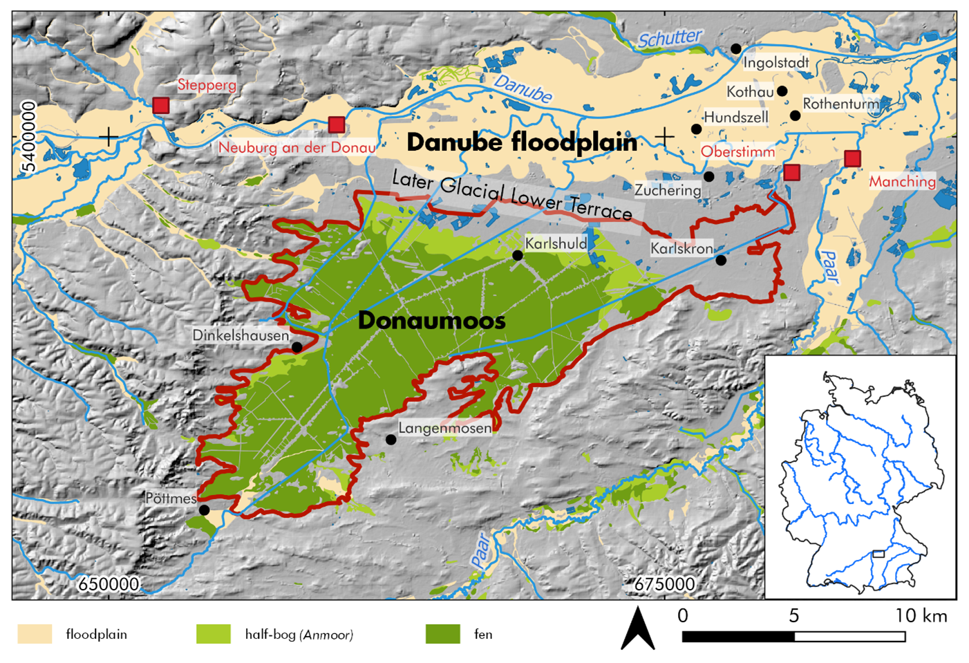
Figure 1Study area of the Greater Donaumoos Region with the Danube River between Neuburg a.d. Donau and Ingolstadt in the north and the Donaumoos fen (framed by red line) in the south. In the study area, long-term multi-temporal old-map analysis was conducted and compared with a review of written sources. Red place names indicate Celtic and Roman sites. Sources: Bavarian Environment Agency (2023); Bavarian Agency for Digitisation, High-Speed Internet and Surveying (2024); and Donaumoos Association (2000).
The Danube River and its southern tributaries drain the Molasse foreland basin and a part of the northern Limestone Alps. Within the selected study section (Fig. 1), the Danube floodplain is incised into the Danube Late Glacial Lower Terrace (Jerz and Schmidt-Kaler, 1999). After the formation of two Early to Middle Holocene terrace levels (Kleinschnitz and Krömer, 2003), a multi-channel meandering river developed with at least three early Subatlantic floodplain levels (Jerz and Peters, 2002). Dating from the early medieval period, a further four terrace stages can be distinguished (Schielein, 2010; Schielein and Schellmann, 2017) that are still inundated during major flood events. Late Holocene terraces feature partially silted-up oxbows (Jerz and Schmidt-Kaler, 1999). The adjacent Donaumoos (ca. 168 km2), the largest of the Bavarian fens, is an extensive fen south of the Danube River (Fig. 1). The Donaumoos is morphologically separated from the Danube floodplain by the flood-free Danube Late Glacial Lower Terrace (Fig. 1), but the hydrogeological connectivity resulted in the formation of a thick peat layer, up to 550 cm in the south (Kortfunke, 1992; Donaumoos Association, 2000; Haas and Cyffka, 2011).
The Celtic settlement (oppidum) at Manching, the Roman forts of Neuburg a.d. Donau and Oberstimm, and the Roman bridge at Stepperg (Fig. 1) highlight the early human intervention in the Danube floodplain (Wendling, 2013; Rieder and Tillmann, 1993). Ingolstadt was founded in the Carolingian period, and the floodplain ground had to be stabilized with wooden piles (Arauner et al., 2006). The first references to villages such as Rothenturm, Kothau and Hundszell (Fig. 1) in the written record relate to their establishment in the Danube floodplain during the 13th and 14th centuries (Nadler, 2004). However, because on the adjacent flood-free Danube Late Glacial Lower Terrace, settlements with names ending in “-ing” (e.g. Zuchering, Fig. 1) date to the early medieval period (Rieder, 1987), it is reasonable to assume that the villages in the Danube floodplain – or at least floodplain land use – originated earlier. The Donaumoos is first mentioned in a written source in 1197. Nobles of the Neuburg royal palace hunted in the area, and inhabitants of the surrounding villages grazed animals there (Nadler, 2004). The early medieval villages at the Donaumoos margins have been documented to only a limited extent (e.g. the burial grounds in Langenmosen and Dinkelshausen, Fig. 1). Although sporadic drainage works in order to gain pasture land were mentioned as early as the 15th century (von Stengel, 1791; Seeburg, 2021), systematic settlement of the Donaumoos fen did not begin before 1778, when Carl Theodor (1724–1799), Elector of Bavaria, ordered drainage works to pave the way for colonization (Nadler, 2004). The first colony – the early modern settlements in the newly drained Donaumoos fen were called colonies – was established in Karlskron in 1791 (Fig. 1). Within a few years, further settlements were founded in the Donaumoos and the fen was gradually drained. This was also the time when reliable mapping began, which can be used for the following evaluation.
3.1 Old-map analysis: review, map selection and critical plausibility check
The analysis of old maps enables the spatiotemporal reconstruction of past socio-natural dynamics. Furthermore, old maps have been used for palaeohydrological reconstructions in floodplains (Hohensinner et al., 2013). Along these lines, our working group has demonstrated the utility of old maps for reconstructing surface water areas in floodplains (Zielhofer et al., 2022). Because maps from the 18th century onwards with sufficient resolution are available for the Greater Donaumoos Region (e.g. von Stengel, 1791), we are able to comparatively evaluate past land reclamation and hydro-engineering efforts.
With the help of old maps, a multi-temporal reconstruction of the Donaumoos canal and drainage ditch network as well as the past Danube River courses and surface water areas over the last 235 years is possible. These proxies are measurable across time in all map series and document hydro-engineering activities in the Donaumoos fen and Danube floodplain. When we chose from among the available maps, attention was paid to their informative value in relation to the scientific question and to a suitable scale (Schuppert, 2013, p. 141). At preferred scales from 1:25 000 to 1:50 000, a selection of maps could be created, which enabled an analysis of 9 snapshots for the Danube floodplain and 10 for the Donaumoos over the last 235 years (Table 1). This covers the entire period from prior to the scheduled land reclamation to the present day. To ensure reusability, transparency and data quality, fundamental metadata for every newly generated digital map file were recorded in tabular form (Kaniecki et al., 2025) following the best-practice recommendations in Schmidt et al. (2024). Particularly with the selected maps of the 18th and early 19th centuries, it should be taken into account that the content depicted is also based on the specific objectives of the person(s) who produced the map (Dickmann, 2021, p. 86). Therefore, careful interpretation of the map content is necessary (Haidvogl et al., 2011, p. 174). According the regressive–iterative approach of Hohensinner et al. (2013), we evaluated the relevance of the historical situation of an older map for the temporally younger situations. This includes plausibility checks for the accuracy of the location of mapped canals and ditches by digitizing from the oldest to the youngest map series, and, in the case of uncertainties, a lidar-based digital elevation model (Bavarian Agency for Digitisation, High-Speed Internet and Surveying, 2024) was used for further checking. Furthermore, as a regressive–iterative process also requires the perspective from the youngest to the oldest stage, the plausibility check was also conducted in reverse order.
Table 1Overview of old and modern maps from the Greater Donaumoos Region (according to Kaniecki et al., 2025). The maps in the table were found to be suitable for the long-term reconstruction of Danube surface water areas and lengths of the Donaumoos canal and drainage ditch network according to position accuracy. This was also possible with some restrictions for the 1788–1808 map series. DM: Donaumoos; Da: Danube floodplain. Sources: (1) N.N. (1788); (2) von Riedl (1791); (3) N.N. (1794); (4) von Riedl (1799–1806); (5) von Riedl (1806); (6) Bayerisches Topographisches Bureau (1812–1867); (7) Königliche Unmittelbare Steuervermessungskommission (1859–1876); (8) Bayerisches Topographisches Bureau (1897); (9) Haushofer (1907); (10) Bayerisches Landesvermessungsamt (1955–1959); (11) Bayerisches Landesvermessungsamt (1982–1987); (12) Bavarian Agency for Digitisation, High-Speed Internet and Surveying (2023).
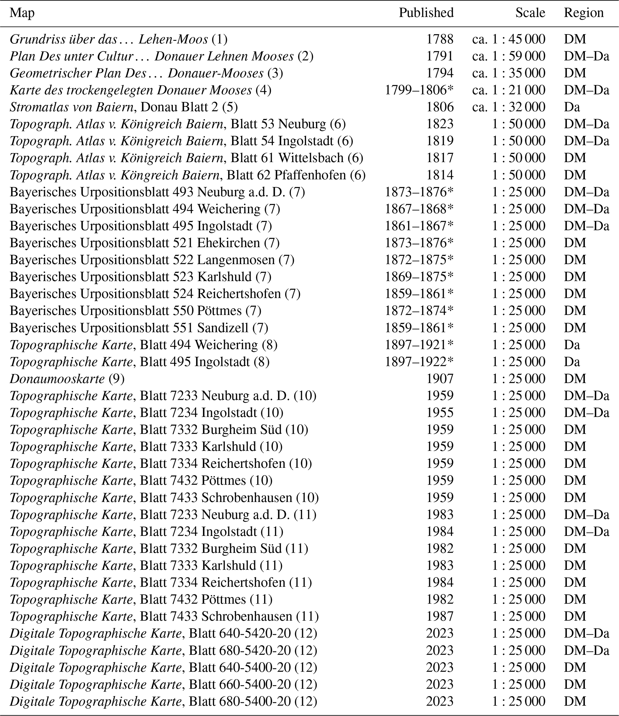
The asterisks (*) indicate probable uncertainty periods of the publication date or map production phases.
3.2 Old-map analysis: chronological classification of the old and topographic maps
The oldest map used here (N.N., 1788) was found in a file of the Donaumoosakten in the state archive of Augsburg. The archive states the file dates to 1788/1789. This is plausible as the commission that was entrusted with the task of draining the Donaumoos was installed in 1787. Furthermore, Stephan von Stengel wrote that, as of 1791, 8000 Tagwerke of the area (about 27 km2) had been drained, which is more than what is depicted in this map (Groening, 2001). This means the map must have been produced between 1787 and 1791.
The second map (von Riedl, 1791) appears in the book Die Austrocknung des Donaumooses (von Stengel, 1791) but was made by Adrian von Riedl. Both in the book and on the map the year 1791 is written, a good sign that this is in fact the year of creation.
The third map (N.N., 1794) is dated to the year 1794 by the Staatliche Bibliothek Neuburg an der Donau. The title indicates that the map shows the situation after the drainage was completed in the years 1790 to 1793. It cannot be that long after 1793 as only the first colony, Karlskron, is shown on the map. It is documented that four colonies existed as of 1794 (von Aretin, 1795), and these are not shown on the map.
The fourth map (von Riedl, 1799–1806) has no date of creation but shows some colonies, e.g. Untermaxfeld and Obermaxfeld. These were named after Max IV. Joseph, Bavarian elector from 1799 on, and therefore the map does not date from before 1799. It is also not younger than 1806 as this is the founding year of the Heinrichsheim colony, which is indicated on the map (Seeburg, 2021, p. 73).
The fifth map (von Riedl, 1806) can be dated to 1806 as the book states this year.
The chronological classification of the Topographical Atlas of the Kingdom of Bavaria (Topographischer Atlas vom Königreich Baiern, 1814–1823) (Table 1) is based on age information given on the individual map sheets (Bayerisches Topographisches Bureau, 1812–1867).
The chronological classification of the Bavarian original topographic survey (Bayerische Urpositionsblätter, 1859–1876) (Table 1) is based on age information given on the individual map sheets with regard to the period of the cartographic survey.
The production age of the Donaumooskarte is the same as the publication date of associated book (Haushofer, 1907). A map is included as an attachment in the book.
The ages of the sheet 494 Weichering (1897–1921) (Bayerisches Topographisches Bureau, 1897) and sheet 495 Ingolstadt (1897–1922) (Bayerisches Topographisches Bureau, 1897) topographic maps are based on the period from the cartographic survey to the publication date.
The chronological classification of the topographic maps (Topographische Karte, 1955–1959; Bayerisches Landesvermessungsamt, 1955–1959 and 1982–1987) refers to the date of publication indicated on the maps.
The age of the current digital topographic map (Bavarian Agency for Digitisation, High-Speed Internet and Surveying, 2023) is constantly updated. The processing status included in this analysis is from 2023.
3.3 Old-map analysis: georeferencing and data processing
Our method of old-map analysis involved digitizing old maps and applying geospatial techniques to align newly created vector data accurately with current geographical coordinates. The georeferencing and vectorization processes were conducted using the QGIS v.3.22.5 geoinformation system. The older maps (1788 to 1806) were rectified using ground control points based on stable features such as churches, road intersections and monuments. It was only from the 1870s onwards that the maps could be accurately aligned with known coordinates of the official map sheet grids. More detailed and additional information about the metadata, the georeferencing process and data access is documented in Kaniecki et al. (2025).
Essentially, the entire canal and drainage ditch network, which is shown on the maps, was digitized. The end of the canal's length was based on reaching the edge of the map, on reaching the border of the Donaumoos shown on the specific map or on the first point where a canal had clearly reached a natural watercourse. In the absence of a boundary on a map, the current Donaumoos extent and boundary defined by the Donaumoos Association (2000) were used.
The Danube River surface water area was vectorized according to the respective legends of the old maps. The Danube River course between Neuburg and Ingolstadt was taken into account. Only features that were clearly recognizable were traced as polygons. The extent of the polygons was traced to the map edge. Meander loops that are clearly part of the main Danube River course were vectorized. Former channels and loops that still have inflow but no outflow (and vice versa) were also vectorized. However, former channels and loops that are completely cut off from the main river course were not included to focus on hydro-engineering activities in the Danube River structure itself (Kaniecki et al., 2025).
3.4 Old-map analysis: integration into the historical context
The analysis of the quantitative old-map data with written sources offers an additional perspective for the interpretation of historical sources (Haidvogl et al., 2011, p. 175). The historical knowledge tapped here had mostly already been compiled within the framework of Bavarian regional history (Seeburg, 2021), specifically dealing with the cultivation of the Donaumoos between 1780 and 1830 while also providing a socio-historical perspective on land reclamation. Another study from the field of environmental history investigated the history of the cultivation and colonization of the Donaumoos (Schmid, 2016). In our study, for the first time the state of historical knowledge is linked to a quantitative old-map analysis, providing a new perspective on the environmental history of the Donaumoos land reclamation and human-induced Danube floodplain formation.
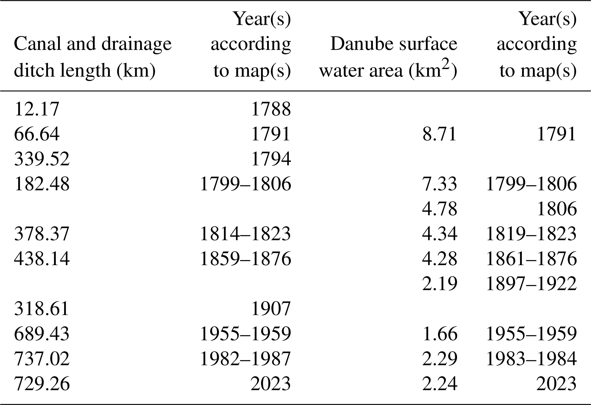
Table 2 summarizes the results of the vectorized canal lengths and the Danube surface water areas on maps spanning the time range from 1788 to 2023.
Table 2Canal and drainage ditch lengths and Danube surface water areas within the Greater Donaumoos Region.
4.1 Transformation of the Donaumoos
At the beginning of the draining of the Donaumoos in 1788, the canal length was 12.17 km, and as of 2023 it was 729.26 km. Our long-term analysis shows that the largest increases in the drainage ditch network occurred between 1788 and 1794 and between 1907 and 1959. The first construction project was a canal in the eastern Donaumoos, which is visible on the map from 1788 (Fig. 2a). This, around 5 km long, was the first section of the so-called main canal (Hauptkanal). A territorial border running south-west to north-east divides the Donaumoos in two. In the north-east of the Donaumoos, there is a second canal with a length of around 7 km. In addition, there are three documented canal courses from south-west to north-east through the centre of the Donaumoos, which are still in the planning stages.
In 1791, the network of drainage ditches and canals was expanded so that the total length was 66.64 km (Fig. 2b). At this point the Donaumoos was still divided into a Palatinate-Neuburg and a Bavarian territory although it was already administratively united. Additional canals expanded from the two original canal areas in the south-west and north-east. In the latter area the expansion was particularly pronounced around the later colonist villages of Karlskron. The canal courses that were initially planned in the central part of the Donaumoos were not implemented; alternative planned canal courses were documented on the old map. As before, the canals in the south-west and north-east were not connected to each other.
The map from 1794 (Fig. 2c) shows that long canals were added that crossed the entire Donaumoos. In the central area these are located on both sides of newly built straight roads. The Donaumoos was still divided into a Palatinate-Neuburg and a Bavarian territory. In some cases, canals had been built that had appeared on the map in 1791 as planned constructions. In 1794 the canal network was denser, particularly in the area of the new colonist village of Karlskron. It is noticeable that especially in the area of the old settlements on the western edges (Rohrenfels, Mitterhausen, Hollenbach, Ehekirchen) and southern edges (Walda, Schorn, Pöttmes, Grimolzhausen, Sandizell, Malzhausen, Langenmosen, Eppertshofen, Lampertshofen, Oberarnbach, Brunnen, Pobenhausen, Adelshausen, Reichertshofen) of the Donaumoos, a network of drainage ditches had developed. The drainage ditches in the area of the old settlements sometimes have arbitrary courses and do not appear to be centrally planned canal courses. It is also surprising that drainage work began in these challenging zones, where the areas were considered to be very wet and where there were very thick peat deposits.
Hardly any new canals appear on the 1799–1806 map (Fig. 3a). In fact, many smaller canals and drainage ditches no longer appear on the southern edge of the Donaumoos. These had either been abandoned or were not recorded. In any case, it is very noticeable that the total length of the canal network at 182.48 km is significantly shorter than the total length in the map from 1794 (Table 2).
The Topographical Atlas of the Kingdom of Bavaria (Topographischer Atlas vom Königreich Baiern, 1814–1823) (Fig. 3c) shows a significant increase in the canal network compared to 1799–1806 (Table 2), although the increase compared to 1794 is relatively small (Fig. 6). For the first time, many new canals appear in the northern Donaumoos around the colonist villages of Obermaxfeld and Stengelheim.
The Bavarian original topographic survey (Bayerische Urpositionsblätter, 1859–1876) (Fig. 4a) on the first exact scale of 1:25 000 shows only a slight increase in the canal network compared to 1814–1823 (Table 2) (Fig. 6).
In 1907, the total canal length had decreased relative to the preceding situation, resulting in a total length of 318.61 km (Fig. 4c). However, newly planned canals are shown on the map and the canal network is numbered.
In the map series from 1955 to 1959, the canal network grows significantly longer to 689.43 km (Figs. 5a and 6). Particularly in the central area of the Donaumoos, the network was laid out according to a plan and became denser. The map sheets from 1982–1987 (Fig. 5b) show that the trend towards increased density continued, which was accompanied by the network reaching its greatest length, 737.02 km (Fig. 6). As of 2023, the total length of canals and ditches had not changed significantly compared to the 1980s (Fig. 5c).
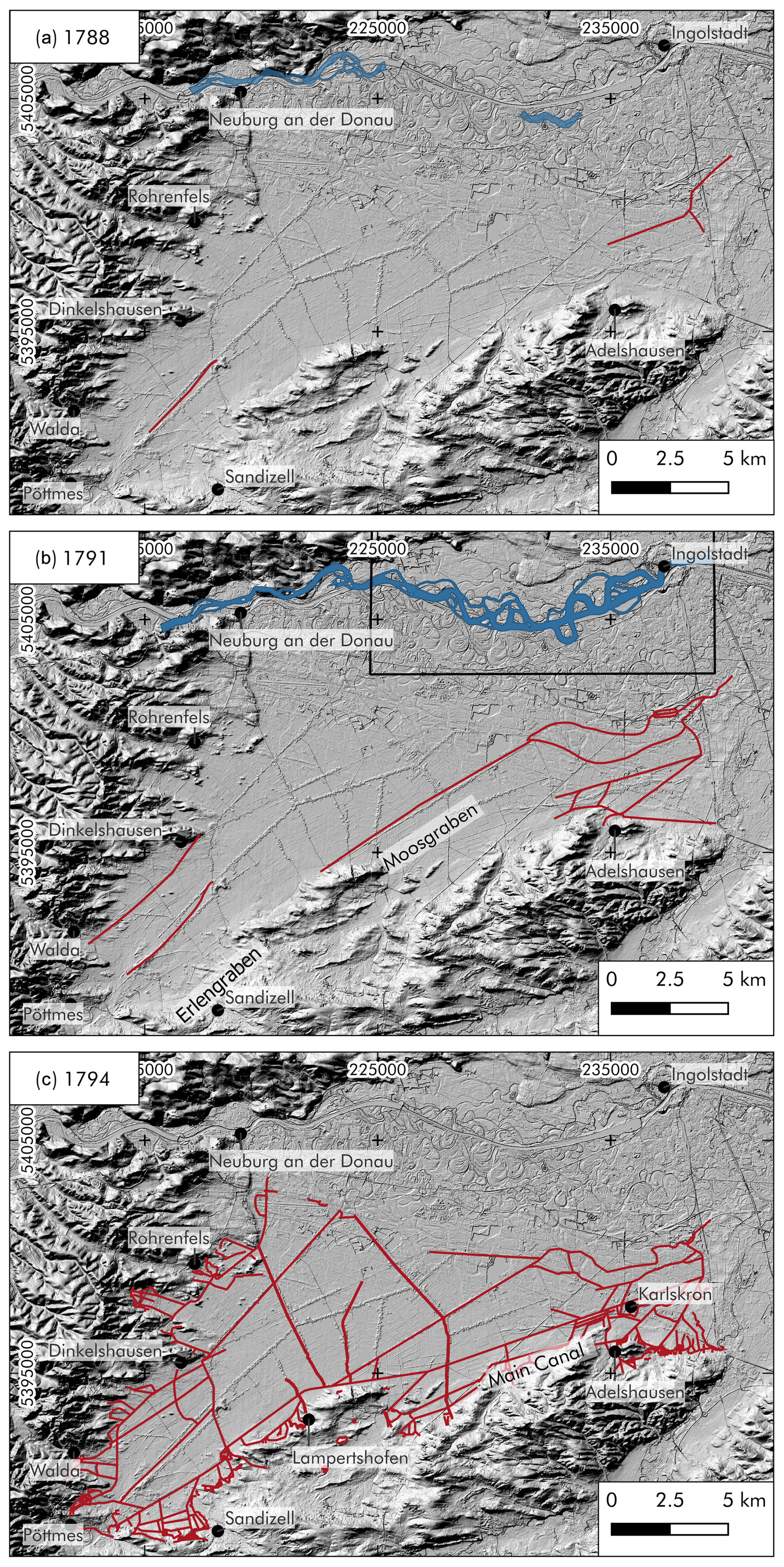
Figure 2Reconstructions of the Donaumoos canal and drainage ditch network and of the Danube surface water area from 1788 to 1794: (a) 1788 – Donaumoos, 12.17 km; (b) 1791 – Donaumoos, 66.64 km, and Danube, 8.71 km2; (c) 1794 – Donaumoos, 339.52 km.
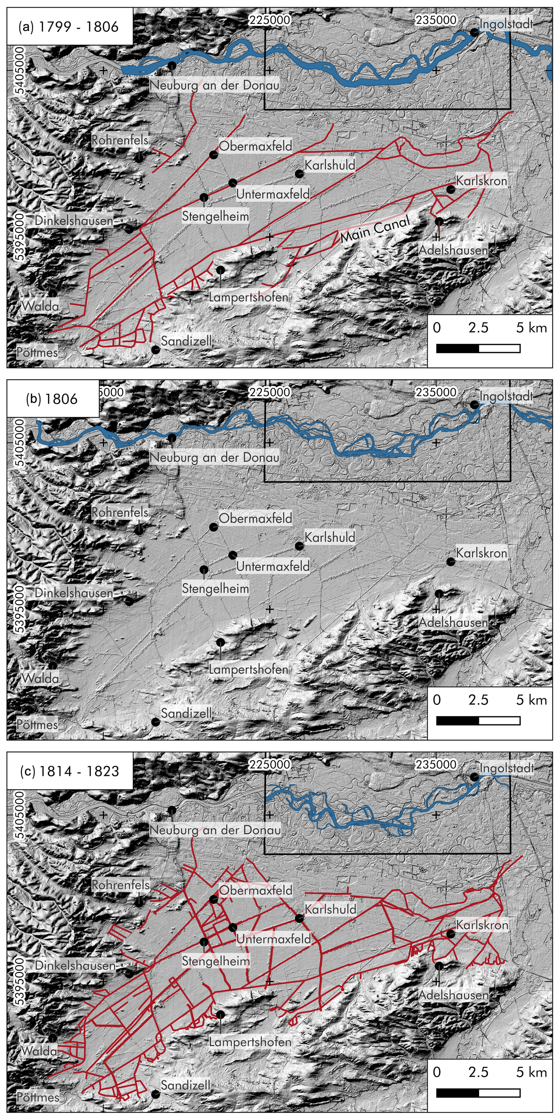
Figure 3Reconstructions of the Donaumoos canal and drainage ditch network and of the Danube surface water area from 1804 to 1820: (a) 1804 (1799–1806) – Donaumoos, 182.48 km, and Danube, 7.33 km2; (b) 1806 (1806–1809) – Danube, 4.78 km2; (c) 1820 (1814–1823) – Donaumoos, 378.37 km, and Danube, 4.34 km2.
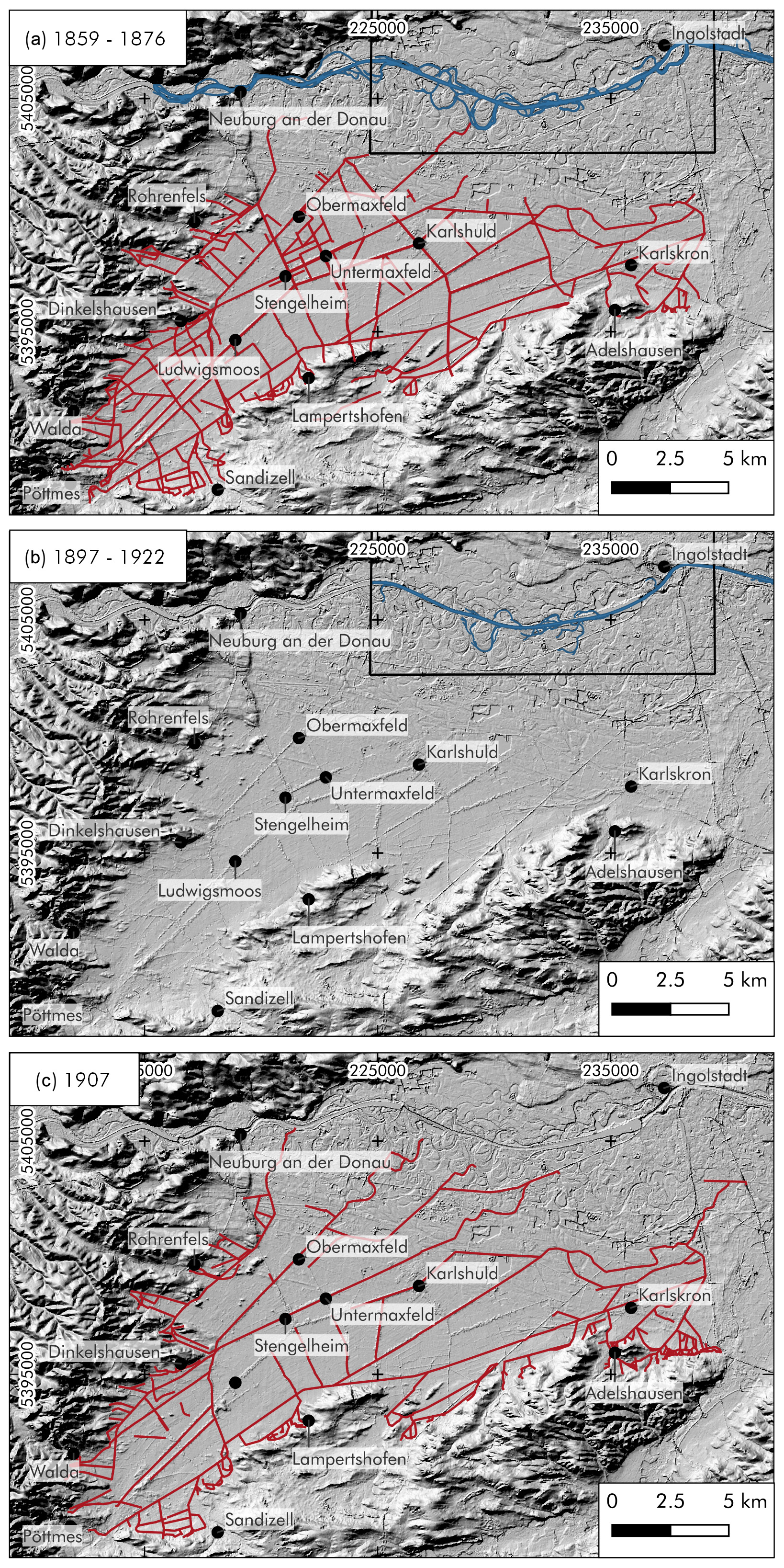
Figure 4Reconstructions of the Donaumoos canal and drainage ditch network and of the Danube surface water area from 1870 to 1907: (a) 1870 (1859–1876) – Donaumoos, 438.14 km, and Danube, 4.28 km2; (b) 1897 (1897–1922) – Danube, 2.18 km2; (c) 1907 – Donaumoos, 318.61 km.

Figure 5Reconstructions of the Donaumoos canal and drainage ditch network and of the Danube surface water area from 1955 to 2023: (a) 1955 (1955–1959) – Donaumoos, 689.43 km, and Danube, 1.66 km2; (b) 1984 (1982–1987) – Donaumoos, 737.02 km, and Danube, 2.29 km2; and (c) 2023 – Donaumoos, 729.26 km, and Danube, 2.24 km2.
4.2 Transformation of the Danube River
The quantification of the digitized Danube surface water areas within the Greater Donaumoos Region shows that they decreased significantly over the last 235 years. In 1791 the Danube had a surface water area of 8.71 km2 (Fig. 2b). At that time, the river structure was still slightly anastomosed. As of 2023 the surface water area had decreased to 2.24 km2 (Fig. 5c). Existing meanders receded, and the area of the actual river course became more and more straight over the period of study. The total area reached its lowest extent, 1.66 km2, in 1955 (Fig. 5a) but has increased since that time. Regarding the river structure, the greatest change is evident on the 1897 map (Fig. 4b). The course of the Danube no longer shows any meanders and has been completely straightened. In 2023, a slightly expanded river course appears east of Neuburg a.d. Donau and west of Ingolstadt (Fig. 5c).
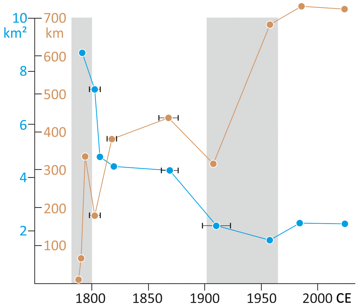
Figure 6Lengths of the Donaumoos canals and ditches (pale brown) and Danube surface water areas (cyan) from 1788 to 2023. The intervals indicate periods or uncertainties of the map production dates (see Sect. 3.2). Pale grey rectangles indicate phases with a particularly strong increase in canal and drainage ditch lengths (great transitions).
5.1 Donaumoos canal and ditch lengths and the historical context
The planning for the first large-scale cultivation of the Donaumoos took 3 years. For this purpose, a cultural commission was set up by Elector Karl Theodor in 1787, which surveyed, planned, mapped and supervised the drainage works. These works took the form of canal and ditch construction (Seeburg, 2021, pp. 60–62). On the one hand, this was only possible because of the unification of the Palatinate-Neuburg and the Electorate of Bavaria areas by the elector, which led to the abolition of the administrative border that ran right through the centre of the Donaumoos. Previously, the Donaumoos being split between two territories had proven to be an insurmountable obstacle for such an intervention. On the other hand, the initial problems of financing the land reclamation were solved by founding a stock corporation, clearing the way for the main work to begin in 1790 (Seeburg, 2021, pp. 57, 66).
The most important construction measure for the drainage was the construction of the main canal (Hauptkanal). With regard to drainage measures, the written sources distinguish between canals and ditches, although it is difficult to determine whether the distinction is based on the construction method, length or depth. It seems that in the 1790s all older watercourses that were not rivers were referred to as “ditches”, e.g. Erlengraben and Moosgraben. The new ones from the 1790s onwards were called canals. The ditches running parallel to the roads were exceptions (N.N., 1794). Von Pechmann (1832, pp. 38–42) generally refers to the new watercourses from the 1790s as canals. Only when the older ones were enlarged was the older designation of ditch sometimes retained. Von Aretin (1795, 65 ff.) uses both terms without providing a definition or clear differentiation. The construction method was quite simple. Ditches and canals were dug with shovels, and the banks of the larger ditches and canals were reinforced with timbers (von Pechmann, 1832, p. 109). The banks were often planted to prevent them from collapsing. The drainage measures took place before the colonies were established, so the labourers for these measures were not colonists but rather day labourers from the surrounding areas. The lighter work was carried out by children, and the heaviest labour was carried out by criminals and homeless people (von Aretin, 1795, pp. XIV–XV).
The construction of the main canal started in the east and then ran across the entire Donaumoos (Seeburg, 2021, p. 67). According to Schmid (2016, p. 398), the main canal was initially said to have reached a total length of 33 km. By vectorizing the main canal length from the map from 1794, this information could be roughly confirmed by the length that was generated, 31.6 km (Fig. 2c). The difference may be due to measurement methods that are inaccurate from today's perspective, as the historical written source used by Schmid (2016) dates from 1832 and the author had not personally witnessed the drainage measures, which had occurred 40 years earlier (von Pechmann, 1832, pp. 39–40).
The further development of the canal network took place around the main canal, from which further canals and drainage ditches were extended. Enclosure canals (Umfassungskanäle) (Seeburg, 2021, p. 62) were built to enclose the Donaumoos in order to be able to drain away the water escaping from the ditches. This hydro-engineering concept can also be seen on the maps. The first drainage ditches ran around the Donaumoos (Fig. 2b and c, maps from 1791 and 1794) and were subsequently connected to one another via smaller canals and drainage ditches and further expanded (Figs. 4c and 5a to c, maps from 1907 to 2023).
The drainage and settlement of the Donaumoos were considered to have been completed before 1800 (Seeburg, 2021, p. 72). So-called colonies, i.e. villages or settlements, were founded early on, starting in 1791, after 8000 Tagwerke (1 Tagwerk corresponds to 3408 m2; 8000 Tagwerke correspond to 27.26 km2) had been drained and levelled (von Stengel, 1791). In addition to people from the area surrounding the fen, settlers from more remote places also found a new home in the colonies. From around 1800 many colonists were refugees from the Rhenish Palatinate (Seeburg, 2021, p. 85).
A written source from 1806 states that the length of the entire canal and ditch network was already more than 350 km (von Kling, 1806, p. 30; Schmid, 2016, p. 398). Our measurements, which were made using the digitization of the canal lengths, based on the map from 1794, yielded a total length of approx. 339 km (Fig. 2c), which is close to that of the written source. However, in 1804, the total length was significantly lower at 182.48 km (Fig. 3a). It may be that the focus of the map (1799–1806) was only on the central Donaumoos area and not on the edges of the fen, so the map does not fully capture the lengths of the drainage ditches and canals. This is probably particularly true for the smaller drainage ditches. However, it is also possible that the contemporary written sources slightly exaggerated the ditch lengths in order to present the project in a better light. Furthermore, around 1800 the environmental conditions became more difficult. A wildfire with an area of 20 km2 is said to have penetrated up to 70 cm deep into the peat layer over a period of 1 week (Schmid, 2016, p. 402). These circumstances might also have been socio-ecological drivers of a decline in the length of the canals and drainage ditches (Figs. 2c and 3a).
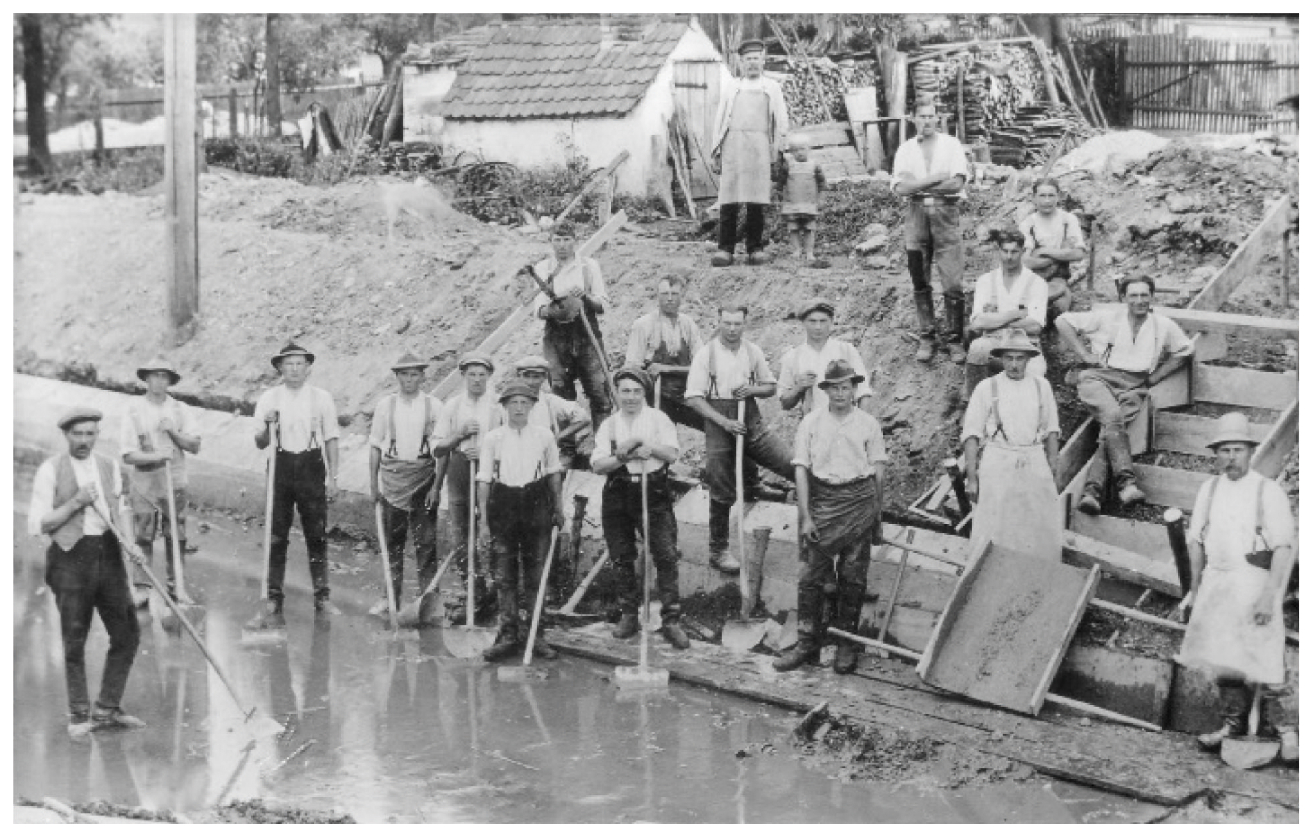
Figure 7Widening of the Ach River at Grabmühle in 1927 as part of the drainage measures. The Ach River is a left tributary of the Paar River (photograph: Archiv Stiftung Donaumoos, Inv. No. 1901).
Furthermore, in the first decades of the 19th century, the return of a portion of the Donaumoos to swampland was documented. A report from around 1820 ties the poor conditions to the neglected maintenance of the canals, drainage ditches and roads (Schmid, 2016, p. 403). This was a result of the low harvests and yields of the fields that had been allocated to the settlers: people did not have the opportunity to support themselves and their families using agricultural means and were often dependent on begging or even theft. In addition to this development, one reason was also the declining electoral – from 1806 royal – interest in the Donaumoos (Seeburg, 2021, p. 72). From 1817 onwards, plans for the reclamation of the Donaumoos were drawn up anew. Ditches were dug again, and some of them were expanded and made navigable. New colonies were founded, and settlers were recruited. They were now granted more land of their own, which was intended to make their living conditions easier through the enjoying of larger yields (Seeburg, 2021, pp. 76–78). The poor conditions were also to be countered by the Donaumoos Association (Donaumoos-Verein), founded in 1829. However, a storm in 1831 destroyed a large number of settlements and cultivated areas. The flooding of the Donaumoos caused the harvest to rot (Schmid, 2016, pp. 401–402). In the 2 decades prior to 1870, the canals and drainage ditches were used to carry out targeted irrigation and drainage. It was not clear which approach was best for the continued agricultural use and settlement of the Donaumoos (Schmid, 2016, p. 405).
The canal and drainage ditch networks around 1820 and 1870 show that not many hydro-engineering activities were carried out in the 19th century. In 1870, the length of canals and drainage ditches reached 438.14 km. The beginning of the 19th century to 1870 represents a period with low development comparatively speaking in the entire 235 years (Figs. 3c, 4a and 6). From 1788 to 1794 the length of the canals increased by around 330 km, whereas in the period from 1794 to 1870 the increase in the length of the canals and drainage ditches was only around 100 km, with a probable decline in 1804. The indecision about how to deal with the Donaumoos is probably also reflected in the low development of the canal network over this longer period. The establishment of colonies was accompanied by economic and ecological misjudgements, so Donaumoos colonization could be considered a failed endeavour until the 1850s (Koch, 2014).
By 1907, the network of canals and drainage ditches had decreased again, with the total length being 318.61 km (Fig. 4c). However, further development in the 20th and into the 21st century resulted in greater increases in the length of the drainage ditches. In 1900, the Mooskulturstelle, the state fen culture office, was established in Karlshuld, and it put in place a cultivation method adapted to the conditions of the Donaumoos that was more successful (Seitz, 1987, p. 154). The improvements and the application of mineral fertilizer led to an agricultural boom in the Donaumoos that saw the canal and drainage ditch network attain a total length of 689.43 km in 1959 (Fig. 5a). From 1907 to 1959 the greatest increase in drainage ditch length over the entire period occurred (Figs. 6 and 7). As a consequence of the drainage, there was ongoing peat subsidence, which was associated with reduced groundwater surface distances and moistened soils. This meant that deepening of the drainage ditches had to be carried out continuously even after 1959 (Seeburg, 2021, p. 79).
Rough calculations of peat losses showed that around 1970, a maximum value of up to 3 m of peat was removed and weathered over an investigated area of 60 km2, meaning that up to one-third of the total peat body was lost (Hoser, 2012, p. 231). With reference to the Donaumoos Association (2022), the Donaumoos peat subsidence can be quantified at least between 2013 and 2022. Accordingly, peat subsidence of more than 20 cm can be observed in the central part of the Donaumoos for this observation period, with mean annual subsidence rates between 1 and 2 cm.
A plan drawn up by the Bavarian State Parliament around 1970 was the first to take both agriculture and nature conservation into account in addressing the Donaumoos. The goals were a stable groundwater level and direct discharges into the Danube without a detour via small drainage ditches (Brenner, 1986). Nevertheless, from the measurement of the drainage ditch lengths on the topographic map from 1984, it is clear that the ditches must have been expanded. The total length of the network was 737.02 km as of that year (Fig. 5b). In addition, more locks were installed in the drainage ditches (Schmid, 2016, p. 405). It is clear that the overall increase in drainage ditch lengths only took place via short drainage ditches because no new long or complex canals and drainage ditches have been built since the 19th century.
The ecological report on the Donaumoos in 1987 was accompanied by recommendations for the restoration of the Donaumoos for the first time (Pfadenhauer et al., 1991). For this purpose, the Donaumoos Association (Donaumoos-Zweckverband) was founded in 1991 and the Donaumoos development concept was presented in 1999 (Donaumoos Association, 2000). The development concept dealt with the harmonization of agricultural use and settlement as well as flood and nature conservation in the Donaumoos and was drafted to address the next 30 years. Peat loss and peat subsidence were identified as the main issues for all mentioned interests. Therefore, the following two scenarios were developed showing the extremes:
-
Scenario 1 forgoes any hydraulic engineering measures and maintenance works in the Donaumoos and expects the area to become wet again due to ongoing peat subsidence and a subsequent decrease in the distance to the groundwater.
-
Scenario 2 attempts to keep the groundwater–surface distance stable, adapting to the peat subsidence through hydro-engineering measures.
In the development concept, a compromise between both scenarios was agreed upon as the guiding principle to be implemented. The intention was to divide the Donaumoos into different functional areas. The settlements and most intensively used arable land would receive flood protection measures, and the few typical wetland habitats would be rewetted and restored (Donaumoos Association, 2002). In general, agricultural land use is too intensive in most of the Donaumoos to allow reversion to a natural fen. Nevertheless, in the southern and western parts of the Donaumoos there are areas where the peat thickness is still high enough that restoration could produce a natural landscape. For the remaining areas, peat-saving, adapted use on rewetted peatland is planned, which is intended to prevent further peat subsidence (Donaumoos Association, 2002, p. 11). The measures to implement this development concept envisage not reducing the extent of the canals and ditches but rather integrating them (Donaumoos Association, 2002, p. 23). Since 2021, the development concept has been under revision as new issues have arisen. Crucially, there is not enough water for rewetting the entire Donaumoos. In the north, peat is fully degraded and, due to peat subsidence, flood risk is now a major problem. The drainage water is running more slowly in the direction to the Danube. Furthermore, there is a new fund of EUR 200 million from Bavaria for the rewetting of the Donaumoos, boosted by the growing importance of creating a major carbon sink (Donaumoos Association, 2022).
The digitized canal lengths from 2023 (Fig. 5c) show few changes compared to 1984. There is a decrease in drainage of around 8 km. The drainage ditch and canal network is therefore 729.26 km long, which exceeds the latest figure presented in the literature (Winterholler, 2020: 473 km). This may be due to the expanded inclusion of the very short and narrow drainage ditches that can be found on the current maps. A very few restoration works may exist as well.
5.2 Danube surface water areas and the historical context
A receiving body of water is necessary to drain the Donaumoos. From the beginning, water from the Donaumoos was diverted into the Danube River, which has also seen hydro-engineering changes in recent centuries (Cyffka and Haas, 2007). During the beginning of the Donaumoos reclamation, it was reported that five river meanders between Neuburg a.d. Donau and Ingolstadt were broken through as part of hydro-engineering measures, which straightened a section of the Danube and shortened it to a length of 18 km (Schmid, 2016, p. 398). These meander breakthroughs appear on the map from 1791 (Fig. 2b). In 1804, the Danube had a surface water area of 7.33 km2 in the floodplain section examined (Fig. 3a) and was already showing initial features of river straightening: there were no meanders on the south side of the main course of the river and the remaining meanders lay north of the Danube. The surface water area of the Danube decreased significantly after 1804, being 4.78 km2 in 1808. The map created that year shows that while the meanders on the north side of the Danube were not broken through, they had a narrower course (Fig. 3b). According to Weissbrod and Binder (2017), the river was further straightened after 1825, as a result of which the course of the Danube between Neuburg a.d. Donau and Ingolstadt was shortened by 17 %. This aligns with a further decrease in surface water area in 1819–1823 (Fig. 3c). On the 1870 map, despite the existence of some meanders, an almost completely straightened river course is evident (Fig. 4a) and the surface water area had decreased to 4.28 km2.
In 1836, consideration was first given to expanding the upper Danube from Ulm to Regensburg into a major shipping route (Baier, 1987, p. 110). The section between Neuburg and Ingolstadt was therefore part of this planning. However, the project was not pushed forward because the implementation encountered various problems. The gradient of the Danube would have led to a large number of dams, and with the construction of the railway line from Ulm to Regensburg, the need for a waterway for larger ships was no longer absolute (Baier, 1987, p. 110).
Between 1870 and 1897 the Danube was completely straightened (Fischer et al., 2013, p. 2). As a result, the river's surface water area decreased drastically to 2.18 km2. There were no longer any meanders, and the Danube only ran as a narrow river (Fig. 4b). With the straightening, the Danube was hydraulically separated from the original floodplain and finally technically blocked by dikes built between 1914 and 1926 (Weissbrod and Binder, 2017, p. 102). Due to the dikes and the subsequent incision of the Danube River, the regular floods (lower than 10-year flood event) could no longer reach the separated floodplain, the ecosystem of which has been severely impaired since then (Weissbrod and Binder, 2017, p. 102).
Around 1897, some small remnants of meanders could still be seen downstream of Ingolstadt, but these had completely disappeared by 1955. As a result, the Danube surface water area fell again to 1.66 km2 by 1955, reaching its lowest value in the period under study (Fig. 5a).
In 1970, two barrages were built near Bergheim and in front of Ingolstadt (Fischer et al., 2013, p. 2). The impoundment of the Danube led to a wider course of the river. As of 2023 the surface water area of the river stood at 2.24 km2 (Fig. 5c). The Danube therefore has a greater surface water area today than when it was straightened in 1897.
At the end of the 20th century, efforts towards ecological upgrading also emerged in the Danube floodplain. In 1990, strategies to restore the degraded Danube floodplain were considered, and they were implemented in 2010. However, the aim of this project was not to revitalize the main river course but rather to restore the Danube floodplain (Stammel et al., 2012). A floodplain stream running parallel to the Danube and fed with Danube water was built, which connected the oxbow lakes of the former Danube and gave the floodplain back flooding areas (Stammel et al., 2012). The straightened Danube remained unaffected.
6.1 Simultaneous developments in the Danube hydro-engineering and Donaumoos reclamation
The simultaneous developments – the decline in the Danube surface water area on the one hand and the increase in drainage ditches in the Donaumoos on the other – can be seen in Fig. 6. The close temporal coupling of the construction works can also be justified by the fact that the draining of the Donaumoos necessitated hydro-engineering activities in the Danube floodplain because the Danube River was where the water from the Donaumoos was to go. The earliest hydro-engineering activity in the Danube floodplain represents the prolongation of the Donaumoos main canal into the Sandrach, a former southern branch of the Danube River (Fig. 2a). The straightening of the Danube River was mainly justified as improving flood protection (Cyffka and Haas, 2007, p. 1) and fitted in well with the goal at the time of draining the Donaumoos in order to enable land reclamation. River straightening, which coincided with land reclamation, has been attested for other fens, such as the large Bourtanger Moor in Emsland (Haverkamp, 2011, p. 272) or the Great Ouse River basin in the East Anglian fens (Mostert, 2018; Pinder et al., 1997).
6.2 Socio-ecological path dependencies from a 235-year-long perspective
Looking at the history of the draining of the Donaumoos fen over the last 235 years, there is no evidence that the land reclamation process has gone smoothly. Problems arose from the lack of experience in drainage and colonization. In particular, the nutrient-poor soils and the difficult-to-control soil–water balance made growing conditions suboptimal (Seeburg, 2021). New improvement measures had to be implemented again and again, which in turn resulted in renewed peat subsidence (Schmid, 2016). The human interventions in the Donaumoos, as in multiple large wetland areas like the large Bourtanger Moor in Emsland (Haverkamp, 2011, p. 259) or in the Eider–Treene–Sorge lowland in Schleswig-Holstein (Reinkemeier, 2013, p. 167), led to drained wetlands. In addition, the floodplains of the receiving rivers have often lost their natural state. In these regions, cost-intensive and complex dismantling of embankments and restoration measures have been planned over the last few decades in order to promote land use that is more geared towards sustainability, climate neutrality and an increase in biodiversity (Donaumoos Association, 2002; Haverkamp, 2011, p. 276). In the Donaumoos, farmers often show resistance due to individual economic constraints. There is EUR 200 million in funding allocated to rewetting the fen and changing the current land use (Donaumoos Association, 2022), but the farmers are typically not in favour. These are the results of the former complex interactions between actors and their environment (Schmid, 2016; Seeburg, 2021) that have led to fundamental socio-ecological path dependencies that to this day have prevented the sustainable development or successful restoration of the Donaumoos.
6.3 Great transitions in the process of land reclamation
The socio-natural transition from the natural, intact Donaumoos fen to a palustrine anthroposphere did not occur continuously but was associated with great transitions. The first one was at the end of the 18th century, and the second was in the first half of the 20th century. In both, the canal and drainage ditch length in the Donaumoos increased noticeably (Fig. 6). These great transitions were characterized by centrally controlled planning and decision-making structures.
In the first great transition, a cultural commission was established by Elector Karl Theodor in 1787, with the power-specific unification of the Palatinate-Neuburg and the Electoral Bavarian areas being an important precondition (Seeburg, 2021). Initially, the most important construction measure for the drainage was the centrally planned construction of the so-called main canal (Hauptkanal) (Fig. 2c). However, there was also a large amount of drainage work, which at the implementation level probably took place more locally. What is striking is the high density of quite randomly aligned smaller drainage ditches in the immediate vicinity of the old settlements on the western and southern edges of the Donaumoos (Fig. 2c). The written sources contain much discussion about the construction works in the area of these settlements. Many polemic papers and complaints from long-time residents in these areas who wanted to prevent reclamation are extant (von Aretin, 1795, 1796; Groening, 2001; Drossbach, 2014). In addition to the numerous complaints, what is also known is that the cultural commission promised to hand over land as free property if the people concerned returned the previously loanable land to the cultural commission, which indeed happened most of the time (von Aretin, 1795; von Pechmann, 1832). There may have been additional benefits if local people also took part in the reclamation themselves, which could explain the rapid and great progress on the southern and western edges of the Donaumoos at that time. To this day, the bases for the people who work in the southern Donaumoos agricultural areas are often the villages outside the Donaumoos that existed prior to the beginning of the reclamation effort. The administrative boundaries of the communities extend into the southern Donaumoos, and the owners of the areas still largely reside in these villages, which therefore must have provided considerable resources during the first phase of Donaumoos reclamation.
The first great transition, which led to a canal length of 330 km by 1794, was followed by a period in the 19th century characterized by setbacks, misjudgement and crises (Koch, 2014). However, with the establishment of the Mooskulturstelle, a second great transition developed in the middle of the 20th century that was accompanied by an agricultural boom (Seitz, 1987) and is evidenced by an enlarged canal and ditch network with a total length of 689.43 km in 1959 (Fig. 6).
At a decadal to multi-decadal scale, it is noteworthy that the hydro-engineering activities to straighten the Danube River had a similar timeline to that of the Donaumoos canal and ditch constructions (Fig. 6). This is not the case in the Lower Havel River Region, where the Havel River hydro-engineering activities were temporally decoupled over a century from the initial land reclamation efforts in the adjacent peatlands that had begun earlier (Zielhofer et al., 2022).
The georeferencing, vectorization and long-term analysis of old maps provide comparative quantitative data sets for the Greater Donaumoos Region over a period of around 235 years. The multi-temporal reconstruction of the lengths of drainage ditches and canals shows that the density of the drainage ditch network has constantly increased. This process was not continuous, however, but was characterized by two distinct phases of expansion, one at the end of the 18th century and the other in the middle of the 20th century. The comparison of the map data sets with the written sources illustrates these specific phases of great transitions, as well as multi-decadal phases of neglect and exhaustion. The methods used to compare the quantitative data from the long-term old-map reconstruction with various written sources have proven to comprise an informative approach. In many cases, the quantitative results of digitization can be compared and impressively supported by the written sources.
The Donaumoos forms a cultural landscape that has experienced far-reaching change over the last 235 years. By draining the fen, the area was intended to be made usable for livestock farming and agriculture and to serve as a place for the settlement of colonists. The first drainage works starting around 1790 were completed at the beginning of the 19th century, and the intervention in the fen was carried out over a large area. The network of canals and drainage ditches was continually expanded through the 20th century so that the Donaumoos completely lost natural zones of ongoing peat formation. The agricultural use of the Donaumoos was accompanied by setbacks from the start, as new problems arose as a result of the drainage. The soils were not fertile, and the onset of peat subsidence repeatedly led to the groundwater–surface distance being too small. The resulting renewed drainage works led to an unsustainable positive feedback mechanism. Due to the long-term human impacts, the fen has been so altered that the existing socio-ecological path dependencies hardly allow any restoration.
In the last 235 years, the Danube River between Neuburg a.d. Donau and Ingolstadt has also been subject to major hydro-engineering changes. The straightening of the Danube River course was accompanied by severe declines in the Danube surface water area. With the embankments and the meander breakthroughs, the natural seasonal inundation of the floodplain was interrupted. Undertaken with the aim of securing a drainage outlet for the Donaumoos, straightening the Danube was also an important phase of the hydro-engineering measures within the context of the Donaumoos reclamation. The Danube was completely straightened in 1897 and was technically completely blocked in the 20th century with raised dams and the installation of weirs.
Overall, the historical reconstruction of the Greater Donaumoos Region towards a palustrine and fluvial anthroposphere allows us to understand the current problems resulting from socio-ecological path dependencies much better. In order to design solutions, it is important to first understand how the transformation of the Donaumoos took place. Especially in the present-day context of a changing understanding of natural resources, these past processes of land reclamation show that these have not been sustainable and solutions only succeed if they are associated with a benefit for the actors involved.
The data that support the findings of this study are available on PANGAEA: https://doi.org/10.1594/PANGAEA.973467 (Kaniecki et al., 2025).
CZ, AL, NM and UW formulated the overarching research goals and aims and are responsible for the acquisition of the financial support for the project leading to this publication. MK, AK, AR and CZ compiled the old-map metadata. MK, AK and AR applied QGIS to analyse and synthesize study data. MK, AK, AR, VS, LB and CZ conducted the investigation process and performed the data collection. MK, AK, AR and CZ developed the standardized multi-temporal old-map analysis. CZ and AK managed and coordinated the research activity. CZ and NM supervised research activity. AK, MK and CZ conducted data visualization.
CZ, AL, AR and VS wrote the original draft of the manuscript with contributions from all co-authors. BS and WF reviewed the original draft of the manuscript before the initial submission and added comments and revisions.
The contact author has declared that none of the authors has any competing interests.
Publisher's note: Copernicus Publications remains neutral with regard to jurisdictional claims made in the text, published maps, institutional affiliations, or any other geographical representation in this paper. While Copernicus Publications makes every effort to include appropriate place names, the final responsibility lies with the authors.
This article is part of the special issue “Floodplain architecture of fluvial anthropospheres”. It is not associated with a conference.
The reconstruction of reclamation, colonization and hydro-engineering in floodplains and peatlands is a key objective of the joint research DFG Priority Programme “On the Way to the Fluvial Anthroposphere” (SPP 2361). This study is part of the corresponding research sub-project “The Lower Havel River and Greater Donaumoos Regions: `Failed' or `successful' reclamation of floodplains and peatlands? – A comparative analysis”. The authors would like to thank the German Research Foundation (DFG) for funding the project. We would like to thank the Open Access Publication Fund of Leipzig University for covering the publication fees. We would like to thank Michelle Köhler and Adrian Löderbusch for their support in setting up a guide for georeferencing the old maps.
This research has been supported by the Deutsche Forschungsgemeinschaft (grant nos. 509915008; LI 1842/5-1, ME 3448/10-1, WE 5518/6-1, ZI 721/28).
This paper was edited by Lukas Werther and reviewed by Marco Panato and one anonymous referee.
Arauner, U., Trappe, M., and Riedel, G.: Stadtgeschichte im Flussbett. Die Rolle von Schutter und Donau, in: Vom Werden einer Stadt – Ingolstadt seit 806, edited by: Riedel, G. and Schönewald, B., Stadt Ingolstadt, Ingolstadt, Germany, 80–85, ISBN-10 3932113438, 2006.
Baier, P.: Die Donau als Schiffahrtsweg – Projekt zum Ausbau der Oberen Donau. In: Die Donau zwischen Lech und Altmühl – Geschichte und Gegenwart einer Kulturlandschaft, edited by: Bauer, H., Verlag Donau Courier, Ingolstadt, 110–114, ISBN10 3920253205, 1987.
Balasse, M., Bălăşescu, A., Tornero, C., Fremondeau, D., Hovsepyan, R., Gillis, R., and Popovici, D.: Investigating the scale of herding in Chalcolithic pastoral communities settled along the Danube River in the 5th millennium BC: A case study at Bordusani-Popina and Harsova-tell (Romania), Quaternary Int., 436, 29–40, https://doi.org/10.1016/j.quaint.2015.07.030, 2017.
Bavarian Agency for Digitisation, High-Speed Internet and Surveying (Bayerisches Landesamt für Digitalisierung, Breitband und Vermessung): Digitale Topographische Karte 1:25.000, https://geodaten.bayern.de/opengeodata/OpenDataDetail.html?pn=dtk25 (last access: 5 May 2024), 2023.
Bavarian Agency for Digitisation, High-Speed Internet and Surveying (Bayerisches Landesamt für Digitalisierung, Breitband und Vermessung: Digital elevation Model 1m (DEM), https://geodaten.bayern.de/opengeodata/OpenDataDetail.html?pn=dgm1 (last access: 18 September 2024), 2024.
Bavarian Environment Agency (Bayerisches Landesamt für Umwelt): Digital Geological Map 1:25,000, https://www.lfu.bayern.de/geologie/geo_karten_schriften/dgk25_uab/index.htm (last access: 17 September 2024), 2023.
Bayerisches Landesvermessungsamt: Topographische Karte 1:25.000, München, https://www.ldbv.bayern.de/produkte//historisch/tk.html (last access: 5 May 2024), 1955–1959.
Bayerisches Landesvermessungsamt: Topographische Karte 1:25.000, München, https://www.ldbv.bayern.de/produkte/historisch/tk.html (last access: 5 May 2024), 1982–1987.
Bayerisches Topographisches Bureau: Topographischer Atlas vom Königreich Baiern 1:50,000, München, https://www.bavarikon.de/object/bav:BSB-CMS-0000000000002414 (last access 25 February 2025), 1812–1867.
Bayerisches Topographisches Bureau: Topographische Karte von Bayern 1:25.000, München, https://www.ldbv.bayern.de/produkte//historisch/tk.html (last access: 5 May 2024), 1897.
Blackbourn, D.: The Conquest of Nature: Water, Landscape and the Making of Modern Germany, W. W. Norton & Company, London, UK, 480 pp., ISBN-10 0393329992, 2007.
Blaus, A., Reitalu, T., Poska, A., Vassiljev, J., and Veski, S.: Mire plant diversity change over the last 10,000 years: Importance of isostatic land uplift, climate and local conditions, J. Ecol., 109, 3634–3651, https://doi.org/10.1111/1365-2745.13742, 2021.
Botter, G., Basso, S., Rodriguez-Iturbe, I., and Rinaldo, A.: Resilience of river flow regimes, P. Natl. Acad. Sci. USA, 110, 12925–12930, https://doi.org/10.1073/pnas.1311920110, 2013.
Brenner, W.: Die Entwässerung des Donaumooses, in: Geschichtliche Entwicklung der Wasserwirtschaft und des Wasserbaus in Bayern Volume 1, edited by: Bayerisches Landesamt für Wasserwirtschaft and Technical University of Munich, Bayerisches Landesamt für Umwelt, Munich, 51–67, ISBN 978-3-930253-24-1, 1986.
Brown, A. G., Lespez, L., Sear, D. A., Macaire, J. J., Houben, P., Klimek, K., Brazier, E. E., Van Oost, K., and Pears, B.: Natural vs anthropogenic streams in Europe: History, ecology and implications for restoration, river-rewilding and riverine ecosystem services, Earth-Sci. Rev. 180, 185–205, https://doi.org/10.1016/j.earscirev.2018.02.001, 2018.
Campopiano, M. and Curtis, D.: Medieval land reclamation and the creation of new societies: Comparing Holland and the Po Valley, c. 800–c. 1500, J. Hist. Geogr. 44, 93–108, https://doi.org/10.1016/j.jhg.2013.10.004, 2013.
Cui, Q. Y., Gaillard, M. J., Lemdahl, G., Stenberg, L., Sugita, S., and Zernova, G: Historical land-use and landscape change in southern Sweden and implications for present and future biodiversity, Ecol. Evol. 4, 3555–3570, https://doi.org/10.1002/ece3.1198, 2014.
Cyffka, B. and Haas, F.: Dynamisierung der Donauauen zwischen Neuburg und Ingolstadt, Hydrobrief, 35, https://d-nb.info/99498636X/34 (last access: 6 May 2025), 2007.
Czerwiński, S. Guzowski, P., Lamentowicz, M., Gałka, M., Karpińska-Kołaczek, M., Poniat, R., Łokas, E., Diaconu, A.C., Schwarzer, J., Miecznik, M., and Kołaczek, P.: Environmental implications of past socioeconomic events in Greater Poland during the last 1200 years. Synthesis of paleoecological and historical data, Quaternary Sci. Rev., 259, 106902, https://doi.org/10.1016/j.quascirev.2021.106902, 2021.
Dickmann, F.: Aktuelle Ansätze landschaftlicher Repräsentationen in Karten, in: Die Landschaft interpretieren: Interdisziplinäre Ansätze, ZELT-Forum11, edited by: Kreisel, W. and Marsden, P. H., Universitätsverlag Göttingen, Göttingen, 85-92, ISBN 978-3-86395-495-65, 2021.
Donaumoos Association (Donaumoos-Zweckverband): Entwicklungskonzept Donaumoos, Neuburg a.d.D., Germany, https://www.donaumoos-zweckverband.de/downloads7ac7d43e (last access: 6 May 2025), 2000.
Donaumoos Association (Donaumoos-Zweckverband): Zukunft für das größte Niedermoor Süddeutschlands. Entwicklungskonzept-Donaumoos 2000–2030. 2. Auflage, Neuburg a.d.D., Germany, 32 p., https://cdn.website-editor.net/fb9d98f7187342bd8c848ad173637fd7/files/uploaded/1. Kurzfassung Entwicklungkonzept Donaumoos.pdf (last access: 7 May 2025), 2002.
Donaumoos Association (Donaumoos-Zweckverband): Donaumoos-Entwicklung bis 2030, https://www.donaumoos-zweckverband.de/dmzv-entwicklung-2030 (last access: 18 September 2024), 2022.
Drossbach, G.: Die Freiherren von Weveld und die Kultivierung des Donaumooses, in: Mensch und Moor. Zur Geschichte der Moornutzung in Bayern, edited by: Fassl, P. and Kettemann, O., Druckerzeugnisse des Schwäbischen Bauernhofmuseums Illerbeuren 24, Kronburg-Illerbeuren, Germany, ISBN-10 393191514X, 2014.
Fischer, P., Stammel, B., Lang, P., Schwab, A., and Cyffka, B.: Hydrologische Dynamik als Motor für die Renaturierung von Auenhabitaten an der Donau zwischen Neuburg und Ingolstadt. in: Fachtagung Ökohydraulik: Leben im, am und mit dem Fluss am 27. und 28. Juni 2013 in der Versuchsanstalt Obernach, edited by Lehrstuhl und Versuchsanstalt für Wasserbau und Wasserwirtschaft, TU München, München, Germany, 119–131, ISBN 978-3-943683-04-2, 2013.
Groening, M.: Karl Theodors stumme Revolution: Stephan Freiherr von Stengel, 1750-1822, und seine staats- und wirtschaftspolitischen Innovationen in Bayern, 1778–99, Verlag Regionalkultur, Ubstadt-Weiher, Germany, 256 p., ISBN 978-3-89735-113-4, 2001.
Gudermann, R.: Morastwelt und Paradies: Ökonomie und Ökologie in der Landwirtschaft am Beispiel der Meliorationen in Westfalen und Brandenburg (1830–1880), Ferdinand Schönigh, Paderborn, 577 p., ISBN 3-506-79607-0, 2000.
Günther, A., Barthelmes, A., Huth, V., Joosten, H., Jurasinski, G., Koebsch, F., and Couwenberg, J.: Prompt rewetting of drained peatlands reduces climate warming despite methane emissions, Nat. Commun. 11, 1644, https://doi.org/10.1038/s41467-020-15499-z, 2020.
Haas, F. and Cyffka, B.: Hydrologisch-bodenkundliche Untersuchungen und Konzepterstellungen zur Wiedervernässung im Moorkörperschutzgebiet Langenmosen. Aueninstitut Neuburg, Eichstätt, Germany, 79 p., https://cdn.website-editor.net/fb9d98f7187342bd8c848ad173637fd7/files/uploaded/Abschlussbericht%2520Langenmosen.pdf (last access: 15 September 2024), 2011.
Haidvogl, G., Hohensinner, S., and Preis, S.: Rekonstruktion historischer Flusslandschaften als Grundlage im Gewässermanagement – potential und limits, Österreichische Wasser- und Abfallwirtschaft 9, 174–182, https://doi.org/10.1007/s00506-011-0335-1, 2011.
Haushofer, M.: Die Entwässerung des Donaumooses bei Neuburg – hier die Verbesserung der wasserwirtschaftlichen Verhältnisse und Kulturzustände im Donaumoose (Donaumoos-Karte als Kartenbeilage), Lampart, Augsburg, Germany, 235 p., http://digital.bib-bvb.de/view/bvb_single/single.jsp?dvs=1746598356849~161&locale=de&VIEWER_URL=/view/bvb_single/single.jsp?&DELIVERY_RULE_ID=39&bfe=view/action/singleViewer.do?dvs=&frameId=1&usePid1=true&usePid2=true (last access: 7 May 2025), 1907.
Haverkamp, M.: Binnenkolonisierung, Moorkultivierung und Torfwirtschaft im Emsland unter besonderer Berücksichtigung des südlichen Bourtanger Moores–Entwicklungslinien und Forschungsstand, TELMA-Berichte der Deutschen Gesellschaft für Moor- und Torfkunde 41, 257–282, https://doi.org/10.23689/fidgeo-2993, 2011.
Hermy, M. and Verheyen, K.: Legacies of the past in the present-day forest biodiversity: A review of past land-use effects on forest plant species composition and diversity, Ecol. Res., 22, 361–371, https://doi.org/10.1007/978-4-431-73238-9_1, 2007.
Hohensinner, S., Sonnlechner, C., Schmid, M., and Winiwarter, V.: Two steps back, one step forward: Reconstructing the dynamic Danube riverscape under human influence in Vienna, Water Hist., 5, 121–143, https://doi.org/10.1007/s12685-013-0076-0, 2013.
Hoser, P.: Die Donaumooskultivierung und ihre Folgen. In: Umweltgeschichte in der Region, Forum–Suevicum 9, Beiträge zur Geschichte Ostschwabens und der benachbarten Regionen 9, edited by: Kiesling, R. and Scheffknecht, W., Narr Francke Attempto Verlag, Tübingen, Germany, ISBN-10 3867643210, 205–235, 2012.
Jerz, H. and Peters, M.: Flussdynamik der Donau bei Ingolstadt in vorgeschichtlicher, geschichtlicher und heutiger Zeit, Rundgespräche der Kommission für Ökologie, 24, 95–108, 2002.
Jerz, H. and Schmidt-Kaler, H.: GK 1:25000 von Bayern. Erläuterungen zum Blatt 7234 Ingolstadt, Bayerisches Geologisches Landesamt, München, Germany, https://www.bestellen.bayern.de/application/applstarter?APPL=eshop&DIR=eshop&ACTIONxSETVAL(artdtl_geo.htm,APGxNODENR:100492,AARTxNR:13082,AARTxNODENR:218046,USERxBODYURL:artdtl.htm,KATALOG:StMUG,AKATxNAME:StMUG,ALLE:x)=X (last access: 7 May 2025), 1999.
Kaiser, K., Lorenz, S., Germer, S., Juschus, O., Küster, M., Libra, J., Bens, O., and Hüttl, R. F.: Late Quaternary evolution of rivers, lakes and peatlands in northeast Germany reflecting past climatic and human impact – an overview, E&G Quaternary Sci. J., 61, 103–132, https://doi.org/10.3285/eg.61.2.01, 2012.
Kaniecki, M., Köhler, A., Seeburg, V., Mehler, N., and Zielhofer, C.: Historical mapping of canals and ditches and the Danube surface water area in the Greater Donaumoos Region over the last 235 years, Pangaea [data set], https://doi.org/10.1594/PANGAEA.973467, 2025.
Kleinschnitz, M. and Krömer, E.: GK 1:25000 von Bayern. Erläuterungen zum Blatt 7233 Neuburg/D., Bayerisches Geologisches Landesamt, München, Germany, https://www.bestellen.bayern.de/application/applstarter?APPL=eshop&DIR=eshop&ACTIONxSETVAL(artdtl_geo.htm,APGxNODENR:100492,AARTxNR:13096,AARTxNODENR:218538,USERxBODYURL:artdtl.htm,KATALOG:StMUG,AKATxNAME:StMUG,ALLE:x)=X (last access: 7 May 2025), 2003.
Koch, F.: Das Donaumoos, in: Mensch und Moor. Zur Geschichte der Moornutzung in Bayern, edited by: Fassl, P. and Kettemann, O., Druckerzeugnisse des Schwäbischen Bauernhofmuseums Illerbeuren 24, Kronburg-Illerbeuren, Germany, 51–65, ISBN-10 393191514X, 2014.
Köhler, A., Wanger-O'Neill, A., Rabiger-Völlmer, J., Herzig, F., Schneider, B., Nebel, S., Werban, U., Pohle, M., Kreck, M., Dietrich, P., Werther, L., Gronenborn, D., Berg, S., and Zielhofer, C.: A hydrological tipping point and onset of Neolithic wetland occupation in Pestenacker (Lech catchment, S Germany), Quaternary Sci. Rev., 278, 107370, https://doi.org/10.1016/j.quascirev.2022.107370, 2022.
Köhler, A., Werban, U., Pohle, P., Rabiger-Völlmer, J., Schneider, B., Wanger-O'Neill, A., Berg, S., Dietrich, P., and Zielhofer, C.: Determining carbon storage of a complex peat stratigraphy using non- and minimal-invasive geophysical prospection techniques (Verlorener Bach and Loosbach valleys, SW Germany), Geoderma, 452, 117095, https://doi.org/10.1016/j.geoderma.2024.117095, 2024.
Königliche Unmittelbare Steuervermessungskommission: Bayerische Uraufnahme, https://commons.wikimedia.org/wiki/Category:Bayerische_Uraufnahme?uselang=de (last access: 5 May 2024), 1859–1876.
Kortfunke, C.: Über die spät- und postglaziale Vegetationsgeschichte des Donaumooses und seiner Umgebung, Dissertationes Botanicae 184, Schweizerbart, Berlin/Stuttgart, Germany, 177 p., ISBN 978-3-443-64096-5, 1992.
N.N.: Grundriss über das sämt. Schrobenhausen Lehen-Moos, nebst den anliegenten Ortschaften (Staatsarchiv Augsburg, Donaumoosakten 497), 1788.
N.N.: Geometrischer Plan Des in einem grossen Sumpfe bestandenen, und in den Jahren 1790, 1791, 1792 und 1793 ganz Cultur-fähig, und trocken gelegten Donauer-Mooses. Staatliche Bibliothek Neuburg a.d.D., https://www.digitale-sammlungen.de/de/view/bsb00112998?page=2 (last access: 6 May 2024), 1794.
Nadler, M.: Neuburg an der Donau. Das Landgericht Neuburg und die Pfleggerichte Burgheim und Reichertshofen, Historischer Atlas von Bayern, Teil Schwaben I 16, München, Germany, https://www.deutsche-digitale-bibliothek.de/item/OQEGQPASIBQNXZ5XGV2RYBARGSHYCDLI (last access: 7 May 2025), 2004.
Nichols, J. E. and Peteet, D. M.: Rapid expansion of northern peatlands and doubled estimate of carbon storage, Nat. Geosci., 12, 917–921, https://doi.org/10.1038/s41561-019-0454-z, 2019.
Niggemann, U.: “Peuplierung” als merkantilistisches Instrument: Privilegierung von Einwanderern und staatlich gelenkte Ansiedlungen, in: Handbuch Staat und Migration in Deutschland seit dem 17. Jahrhundert, edited by: Oltmer, J., De Gruyter Oldenbourg, Berlin, Germany, 171–218, https://doi.org/10.1515/9783110345391, 2015.
Macklin, M. G. and Lewin, J.: River stresses in anthropogenic times: Large-scale global patterns and extended environmental timelines, Prog. Phys. Geogr. 43, 3–23, https://doi.org/10.1177/0309133318803013, 2019.
Manton, M., Makrickas, E., Banaszuk, P., Kołos, A., Kamocki, A., Grygoruk, M., Stachowicz, M., Jarašius, L., Zableckis, N., and Sendžikaitė, J.: Assessment and Spatial Planning for Peatland Conservation and Restoration: Europe's Trans-Border Neman River Basin as a Case Study, Land, 10, 174, https://doi.org/10.3390/land10020174, 2021.
Meybeck, M.: Global analysis of river systems: From Earth system controls to Anthropocene syndromes, Philos. Trans. R. Soc. B, 358, 1935–1955, https://doi.org/10.1098/rstb.2003.1379, 2003.
Mostert, E.: River basin management and community: the Great Ouse Basin, 1850–present, Int. J. River Basin Manage., 16, 51–59, https://doi.org/10.1080/15715124.2017.1339355, 2018.
Peters, J.: Historische Einführung: Neuholland von den Anfängen bis zur Mitte des 18. Jahrhunderts, in: Märkische Bauerntagebücher des 18. und 19. Jahrhunderts, edited by: Peters, J., Harnisch, H., and Enders, L., Franz Steiner Verlag, Weimar, Germany, 18–81, ISBN 978-3-8305-4345-9, 1989.
Pfadenhauer, J., Krüger, G. M., and Muhr, E.: Ökologisches Gutachten Donaumoos. Konzept zur künftigen Landschaftsentwicklung, Schriftenreihe, Bayerisches Landesamt für Umweltschutz 109, München, Germany, 88 p., https://www.deutsche-digitale-bibliothek.de/item/SM4XQUQXV4NDMFJ3Z4HW3XZN65IL3HUJ (last access: 7 May 2025), 1991.
Pierik, H. J.: Landscape changes and human–landscape interaction during the first millennium AD in the Netherlands, Neth. J. Geosci., 100, e11, https://doi.org/10.1017/njg.2021.8, 2021.
Pinder, L. C. V., Marker, A. F. H., Mann, R. H. K., Bass, J. A. B., and Copp, G. H.: The River Great Ouse, a highly eutrophic, slow-flowing, regulated, lowland river in eastern England, Regul. River, 13, 203–218, 1997.
Reinkemeier, P.: Moore in Schleswig-Holstein–Moorkultivierung, Moorkolonisation und Torfabbau, Schauplätze der Umweltgeschichte in Schleswig-Holstein, edited by: Collet, D. and Jakubowski-Tiessen, M., Universitätsverlag Göttingen, Göttingen, Germnay, 165–179, https://naturschutz.uni-goettingen.de/files/papers/222.pdf (last access: 19 September 2024), 2013.
Rieder, K. H.: Ein frühmittelalterliches Dorf bei Zuchering, in: Die Donau zwischen Lech und Altmühl, edited by: Bauer, H., Donau Courier, Ingolstadt, Germany, 18–31 pp., https://www.deutsche-digitale-bibliothek.de/item/C6XRNQGBFLETOEV4Q5J4REWLSCEEEP2I (last access: 7 May 2025), 1987.
Rieder, K. H. and Tillmann, A.: Neuburg an der Donau. Archäologie rund um den Stadtberg, Verlag Marie Leidorf, Buch am Erlbach, Germany, ISBN-10 3924734119, 1993.
Schielein, P.: Neuzeitliche Flusslaufverlagerungen des Lechs und der Donau im Lechmündungsgebiet – qualitative und quantitative Analysen historischer Karten, Bamberger Geographische Schriften 24, 215–241, https://www.uni-bamberg.de/fileadmin/geo2/Publikationen/BaGeogrSchri24_Schielein2010.pdf (last access: 17 September 2024), 2010.
Schielein, P. and Schellmann, G.: Erläuterungen zur quartärgeologischen Karte 1:25.000 des Lech- und Donautals auf Blatt 7231 Genderkingen, Bamberger Geographische Schriften SF 12, 171–192, https://www.uni-bamberg.de/fileadmin/geo2/Publikationen/Publik2017/7231_Genderkingen_Schielein_Schellmann_2016G.pdf (last access 17 September 2024), 2017.
Schmid, M.: Long-Term Risks of Colonization: The Bavarian `Donaumoos', in: Social Ecology. Society-Nature Relations across Time and Space, edited by: Haberl, H., Fischer-Kowalski, M., Krausmann, F., and Winiwarter, V., Human-Environment Interactions 5, Springer, Cham, 391–415, https://doi.org/10.1007/978-3-319-33326-7_19, 2016.
Schmidt, J., Voigt, A., Seeburg, V., Köhler, A., Offermann, M., Zielhofer, C., and Werther, L.: Georeferencing and other strategies to spatialise information from old maps. A collection of best practice recommendations/Georeferenzierung und andere Strategien zur Verräumlichung von Informationen aus Altkarten – ein Leitfaden, i.DAI.repo, Berlin, Germany, https://doi.org/10.34780/8XZW-GF31, 2024.
Schuppert, C.: GIS-gestützte historisch-geographische Untersuchungen frühkeltischer Fürstensitze in Südwestdeutschland, Forschungen und Berichte zur Vor- und Frühgeschichte in Baden-Württemberg 126, Landesamt für Denkmalpflege im Regierungspräsidium Stuttgart, 250 p., ISBN 978-3-8062-2885-4, 2013.
Seeburg, V.: Bodenkultivierung im Donaumoos. Ein Beitrag zur Umwelt- und Sozialgeschichte zwischen 1780 und 1830, FAU University Press, Erlangen, Germany, https://doi.org/10.25593/978-3-96147-468-4, 2021.
Seitz, R.: Das Donaumoos – Entstehung und Besiedelung einer Ausräumungslandschaft, in: Die Donau zwischen Lech und Altmühl – Geschichte und Gegenwart einer Kulturlandschaft, edited by: Bauer, H., Verlag Donau Courier, Ingolstadt, Germany, 150–155, ISBN 3920253205, 1987.
Stammel, B., Cyffka, B., Geist, J., Müller, M., Pander, J., Blasch, G., Fischer, P., Gruppe, A., Haas, F., Kilg, M., Lang, P., Schopf, R., Schwab, A., Utschik, H., and Weissbrod, M.: Floodplain restoration on the Upper Danube (Germany) by re-establishing water and sediment dynamics: A scientific monitoring as part of the implementation, River Syst., 20, 55–70, https://doi.org/10.1127/1868-5749/2011/020-0033, 2012.
Stammel, B., Fischer, C., Cyffka, B., Albert, C., Damm, C., Dehnhardt, A., Fischer, H., Foeckler, F., Gerstner, L., Hoffmann, T.G., Iwanowski, J., Kasperidus, H.D., Linnemann, K., Mehl, D., Podschun, S.A., Rayanov, M., Ritz, S., Rumm, A., Scholz, M., Schulz-Zunkel, C., Thiele, J., Venohr, M., Haaren, C. von, Pusch, M. T., and Gelhaus, M.: Assessing land use and flood management impacts on ecosystem services in a river landscape (Upper Danube, Germany), River Res. Appl., 37, 209–220, https://doi.org/10.1002/rra.3669, 2021.
Squatriti, P. (Ed.): Working with water in Medieval Europe, Technology and Change in History 3, De Gruyter Brill, Leiden, Netherlands, 446 p., ISBN 978-90-04-10680-2, 2000.
Swindles, G. T., Morris, P. J., Mullan, D. J., Payne, R. J., Roland, T. P., Amesbury, M. J., Lamentowicz, M., Turner, T. E., Gallego-Sala, A., Sim, T., Barr, I. D., Blaauw, M., Blundell, A., Chambers, F. M., Charman, D. J., Feurdean, A., Galloway, J. M., Gałka, M., Green, S. M., Kajukało, K., Karofeld, E., Korhola, A., Lamentowicz, Ł., Langdon, P., Marcisz, K., Mauquoy, D., Mazei, Y., McKeown, M. M., Mitchell, E. A. D., Novenko, E., Plunkett, G., Roe, H. M., Schoning, K., Sillasoo, Ü., Tsyganov, A. N., van der Linden, M., Väliranta, M., and Warner, B.: Widespread drying of European peatlands in recent centuries, Nat. Geosci., 12, 922–928, https://doi.org/10.1038/s41561-019-0462-z, 2019.
Swinnen, W., Broothaerts, N., Hoevers, R., and Verstraeten, G.: Anthropogenic legacy effects control sediment and organic carbon storage in temperate river floodplains, Catena, 195, 104897, https://doi.org/10.1016/j.catena.2020.104897, 2020.
Tanneberger, F., Moen, A., Barthelmes, A., Lewis, E., Miles, L., Sirin, A., Tegetmeyer, C., and Joosten, H.: Mires in Europe – Regional diversity, condition and protection, Diversity, 13, 381, https://doi.org/10.3390/d13080381, 2021.
Tarolli, P., Cao, W., Sofia, G., Evans, D., and Ellis, E. C.: From features to fingerprints: A general diagnostic framework for Anthropogenic geomorphology, Prog. Phys. Geogr., 43, 95–128, https://doi.org/10.1177/0309133318825284, 2019.
Tockner, K., Tonolla, D., Bremerich, V., Jähnig, S. C., Robinson, C. T., and Zarfl, C.: Introduction to European rivers, in: Rivers of Europe, 2nd edition, edited by: Tockner, K., Zarfl, C., and Robinson, C. T., Elsevier, London, UK, 1–26, https://doi.org/10.1016/B978-0-08-102612-0.00001-8, 2022.
van de Ven, G. P.: Manmade lowlands: History of water management and land reclamation in the Netherlands, Stichting Matrijs, Utrecht, Netherlands, ISBN-10 9053450300, 1994.
Vermaat, J. E., Wagtendonk, A. J., Brouwer, R., Sheremet, O., Ansink, E., Brockhoff, T., Plug, M., Hellsten, S., Aroviita, J., Tylec, L., Giełczewski, M., Kohut, L., Brabec, K., Haverkamp, J., Poppe, M., Böck, K., Coerssen, M., Segersten, J., and Hering, D.: Assessing the societal benefits of river restoration using the ecosystem services approach, Hydrobiologia, 769, 121–135, https://doi.org/10.1007/s10750-015-2482-z, 121-135, 2016.
von Aretin, J. G.: Aktenmässige Donaumoos-Kulturs-Geschichte. Churfürstlichen Donaumooskulturs-Kommißion, Schwan und Götz, Mannheim, Germany, https://www.bavarikon.de/object/bav:BSB-MDZ-00000BSB10982714?lang=de (last access: 7 May 2025), 1795.
von Aretin, J. G.: Vier wichtige Aktenstücke zur Kultursgeschichte des Donaumooses in Bayern. Ein Beytrag zu einer allgemeinen Kultursgeschichte diess Landes, Germanien, Augsburg, Germany, https://www.deutsche-digitale-bibliothek.de/item/UIKGJKV47XR6LJTOFQQIBCSH5M2M7JXM (last access: 7 May 2025), 1796.
von Kling, J. P.: Beschreibung eines Kulturversuches im Donaumoos, Joseph Lindauer, München, Germany, https://www.digitale-sammlungen.de/de/view/bsb10724022?q=Donaumoos&page=,1 (last access 7 May 2025), 1806.
von Pechmann, H.: Geschichte der Austrocknung und der Cultur des Donaumoores in Bayern, München, Stuttgart, Cotta'sche Verlagsbuchhandlung, Tübingen, Germany, https://books.google.de/books?id=q0VSAAAAcAAJ&hl=de (last access: 17 September 2024), 1832.
von Riedl, A.: Plan Des unter Cultur stehenden Churfürstlichen Schrobenhauser oder Donauer Lehnen Mooses, n.p., https://www.digitale-sammlungen.de/de/view/bsb10336154?page=22,23 (last access: 7 May 2025), 1791.
von Riedl, A.: Karte des trockengelegten Donauer Mooses dann der Chaussée von Poernbach Nach Neuburg, Joseph Lentner Verlag, München, Germany, https://www.bavarikon.de/object/bav:BSB-MAP-00000BSB00090588?p=1&cq=trockengelegten donaumoos&lang=de (last access: 6 May 2024), 1799–1806.
von Riedl, A.: Stromatlas von Baiern, München, Germany, https://www.bavarikon.de/object/bav:BSB-MAP-0002MAPP152QE103?lang=de (last access: 6 May 2024), 1806.
von Stengel, S.: Die Austrocknung des Donaumooses, München, Germany, https://www.digitale-sammlungen.de/de/details/bsb10336154 (last access: 7 May 2025), 1791.
Weissbrod, M. and Binder, F.: Auswirkung eines Staustufenbaus auf den Radialzuwachs von Stieleichen (Quercus robur L.) an der bayerischen Donau, Forstarchiv, 88, 102, 2017.
Wendling, H.: Manching reconsidered. New perspectives on settlement dynamics and urbanization in Iron Age Central Europe, Eur. J. Archaeol. 16, 459–490, https://doi.org/10.1179/1461957113Y.0000000031, 2013.
Werther, L., Mehler, N., Schenk, G. J., and Zielhofer, C.: On the way to the Fluvial Anthroposphere – Current limitations and perspectives of multidisciplinary research, Water, 13, 2188, https://doi.org/10.3390/w13162188, 2021.
Wichmann, S. and Nordt, A.: Unlocking the potential of peatlands and paludiculture to achieve Germany's climate targets: obstacles and major fields of action, Front. Clim., 6, 1380625, https://doi.org/10.3389/fclim.2024.1380625, 2024.
Winiwarter, V., Schmid, M., and Dressel, G.: Looking at half a millennium of co-existence. The Danube in Vienna as a socio-natural site, Water Hist., 5, 101–119, https://doi.org/10.1007/s12685-013-0079-x, 2013.
Winterholler, M.: Moorrenaturierungen – vom Klimaschutzprogramm Bayern (KLIP) zum Fachplan Moore, ANLiegen Natur, 42, 7–18, https://www.anl.bayern.de/publikationen/anliegen/doc/an42112winterholler_2020_moorschutz.pdf (last access: 16 September 2024), 2020.
Zak, D., Maagaard, A. L., and Liu, H.: Restoring riparian peatlands for inland waters: A European perspective, in Encyclopedia of Inland Waters, Elsevier, 2nd Edition, 3, 276–287, https://doi.org/10.1016/b978-0-12-819166-8.00127-4, 2022.
Zielhofer, C., Schmidt, J., Reiche, N., Tautenhahn, M., Ballasus, B., Burkart, M., Linstädter, A., Dietze, E., Kaiser, K., and Mehler, N.: The Lower Havel River Region (Brandenburg, Germany) – A 230-year-long historical map record indicates a decrease in surface water areas and groundwater levels, Water, 14, 480, https://doi.org/10.3390/w14030480, 2022.
- How to cite
- Abstract
- Kurzfassung
- Introduction
- Study area
- Methods
- Results
- Comparison of the old-map analysis with the written sources
- Discussion
- Conclusions
- Data availability
- Author contributions
- Competing interests
- Disclaimer
- Special issue statement
- Acknowledgements
- Financial support
- Review statement
- References