the Creative Commons Attribution 4.0 License.
the Creative Commons Attribution 4.0 License.
 | 21 Aug 2025
A millennium of ore mining and smelting in the eastern Harz: a geospatial database spanning from the medieval period to the 20th century
Johannes Keßels
Anna Swieder
Philipp Schulte
Götz Alper
Christopher Tober
Susanne Friederich
Frank Lehmkuhl
Keßels, J., Swieder, A., Schulte, P., Alper, G., Tober, C., Friederich, S., and Lehmkuhl, F.: A millennium of ore mining and smelting in the eastern Harz: a geospatial database spanning from the medieval period to the 20th century, E&G Quaternary Sci. J., 74, 129–145, https://doi.org/10.5194/egqsj-74-129-2025, 2025.
The mid-mountain ranges are characterised by a medieval land occupation driven by various factors, which in turn affected the river systems. In particular, extraction and smelting activity led to distinct signals in floodplain sediments, serving as valuable tracers for reconstructing past environmental conditions and assessing anthropogenic impacts. This study creates the basis to link existing historical and geo-/montan-archaeological data with future geoscientific research for the Selke River catchment. A database of mines, smelters, and settlement structures was derived from (1) written sources, (2) old maps, and (3) a dataset of anthropogenic surface structures. The study focuses on the spatial alignment of the mining operations with the corresponding vein systems and their chronology and correlates the smelting activity with river kilometres and hydrological subregions. Ultimately, this research defines (a) three key areas that are characterised to varying degrees by mining activity and (b) discusses possible downstream impacts on overbank deposits from these historical mining locations.
Die mittelalterliche Landnahme der Mittelgebirge ist auf verschiedene Push- und Pull-Faktoren zurückzuführen. Durch diese Landnahme haben sich die Flusssysteme der Mittelgebirge stark verändert. Insbesondere die montanbergbaulichen Aktivitäten haben zu deutlichen geochemischen Signalen in den Auensedimenten geführt, welche heute als wichtige Indikatoren für Bewertung anthropogener Einflüsse sowie die Rekonstruktion vergangener Umweltbedingungen herangezogen werden. Die vorliegende Studie stellt eine Verknüpfung historischer und montanarchäologischer Daten mit geowissenschaftlichen Forschungen im Flusseinzugsgebiet der Selke dar. Dazu wurden (1) schriftliche Quellen, (2) Altkarten und (3) ein Datensatz zu anthropogenen Oberflächenstrukturen ausgewertet. Ergebnis ist insbesondere die Zusammenstellung von Bergwerken, Hütten und Siedlungsstrukturen. Die räumliche Verbreitung und Chronologie der Bergbaustandorte werden dargestellt und die Verhüttungsaktivitäten zusätzlich mit Flusskilometern und hydrologischen Teilregionen verknüpft. Letztlich definiert diese Untersuchung (a) drei Schwerpunktbereiche, die in unterschiedlichem Ausmaß durch Bergbauaktivitäten geprägt sind, und (b) diskutiert mögliche Auswirkung der historischen Montanaktivitäten auf die flussabwärts abgelagerten Auensedimente.
- Article
(12157 KB) - Full-text XML
-
Supplement
(362 KB) - BibTeX
- EndNote


The Harz Mountains are considered to be one of the most ore-rich regions in Europe (Stedingk, 2021). At least since the Middle Ages, they have been regarded as an important economic centre for the mining industry with supra-regional significance. The development of towns such as Goslar and Quedlinburg into centres of political power by becoming part of the Königspfalzen network in the early Middle Ages, the founding of new (e.g. Benedictine and Cistercian) monasteries, and the indications of far-reaching trade relations exemplify the importance of this region for metal supply (Liessmann, 2010; Asmus, 2018; Manganaro, 2020).
Particularly in the western Harz region, mining and smelting activity has been the focus of extensive research for many decades. The results of these historical and archaeological investigations contribute to a comprehensive understanding of the location and utilisation of mines, smelting sites (Klappauf et al., 1997; Klappauf, 2014), and former settlements (Denecke, 1992). Geoscientific investigations intend to extend this record by adding information about former land use, environmental conditions, and the effects of the low mountain range's prehistoric and medieval land occupation. For the western Harz region, this includes studies on charcoal to reconstruct vegetation changes (Knapp et al., 2013; Robin et al., 2013) or on overbank deposits and their heavy metal content to identify phases of land use and reconstruct mining periods (Matschullat et al., 1997; Monna et al., 2000; Steingräber et al., 2022). Nevertheless, the historical archaeological evidence is a crucial framework for reasonably interpreting the geoscientific data (Schmidt-Wygasch et al., 2010; Parker et al., 2022).
The scope of these investigations commonly refers to the deposits of the western Harz Mountains. There is only little (geo-)archaeological research on early mining and smelting for the eastern Harz region (Alper, 2008). This started to change due to the investigations conducted, for example, by Alper (2008, 2016) for iron mining around the Elbingerode Complex and by Swieder (2021, 2022), who added thousands of archaeological structures with precise location data in the eastern Harz Mountains to known historical sites, representing a significant increase in available data.
The present study collates and analyses the available geological, historical, and archaeological datasets related to the history of mining, settlement, and land use in the Selke River catchment covering the eastern Harz vein district. The main objective is to identify individual mining and metallurgical centres and thus locate points at which the impact on fluvial records regarding grain size distributions and geochemical signals must be considered in the downstream direction and determine their temporal development. The chronological consideration is used to distinguish periods defined by distinct changes in mining/smelting operations that may have had a definite influence on the landscape evolution. The catchment of the Selke River, as a typical example of a low mountain river with its mining history, offers a framework to study past river developments and sediment dynamics since the Middle Ages, addressing the interactions between the river and human settlement within the scope of the SPP 2361: On the Way to the Fluvial Anthroposphere (Werther et al., 2021).
The Selke River catchment in the eastern Harz Mountains is characterised by the transition between the high-elevation regions of the low mountain ranges and the loess-dominated lowlands. The primary focus is on the middle and upper catchment, covering an area of about 180 km2 in the Harz Mountains south of the Ramberg granite (cf. Fig. 1). The Selke River's headwaters originate above 500 m a.s.l., reaching the lowland at Meisdorf (180 m a.s.l.) after a flow length of about 42 km. Henceforth, the term Selke River denotes this region, highlighted in Fig. 1.
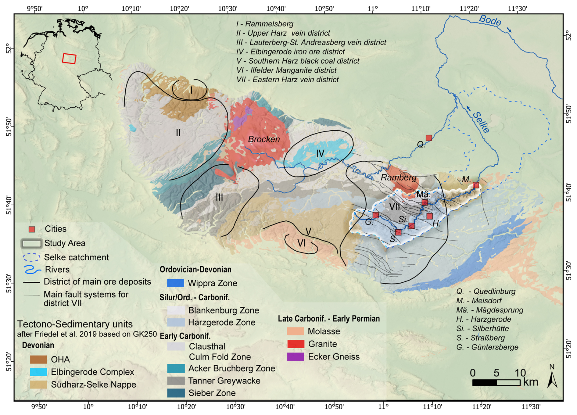
Figure 1Map of the Harz Mountains and location of the study area. The districts of the main ore deposits are based on Mohr (1978). See Copernicus (2016) for information on the DEM in the background.
The study area has two primary morphological features. First, there are gently to moderately sloped remnants of the peneplains, where island-like agricultural regions have emerged within an otherwise dominant forest landscape, combined with V-shaped river valleys along the main course of the Selke River, 100 to 200 m in width. Second, where the Selke River intersects the morphologically more resistant Tanner Greywacke Zone, it creates a deeply incised, narrow, V-shaped valley.
Another important geological feature is the mineral veins that strike parallel to the northern edge of the Harz Mountains (WNW–ESE) as part of the eastern Harz vein district (Fig. 1). The vein mineralisation is linked to post-Variscan hydrothermal activity composed of different mineralisation stages. The sulfide and fluorite stages are the most important for the vein deposits in the study area, during which Pb-Zn (± Cu-Ag) deposits and fluorite minerals precipitated, respectively (Graaf et al., 2020).
The timeline in Fig. 2 displays known dates and events associated with the occupation and mining history of the study area. Concerning settlement history, some archaeological findings indicate that the region may have been settled in prehistoric times, such as a hillfort upstream of Meisdorf linked to the Iron Age (Fig. 2: Hillfort Bartenberg). However, the permanent settlement is currently considered to reach back to the early Middle Ages, given the current understanding that the Harz Mountains were not extensively populated during the Migration Period (Gringmuth-Dallmer, 1992). After the initial colonisation of the mountainous region many settlements were abandoned between the 14th and 16th centuries. Schmidt (2000) estimates a desertification quotient of 72 % for the entire eastern Harz region (Fig. 2).
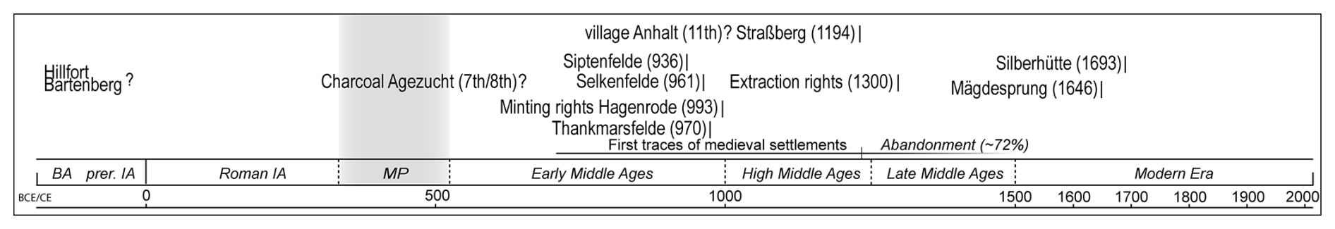
Figure 2Timeline of individual dates and events linked to the study area's occupation progress and mining history (see references in Sect. 3). BA = Bronze Age, prer. IA = pre-Roman Iron Age, Roman IA = Roman Iron Age, and MP = Migration Period.
The first settlement evidence, emerging during the early Middle Ages, includes, for example, the Königspfalz of Siptenfelde and the settlement Selkenfelde, as well as the two monasteries of Thankmarsfelde, which was relocated to Nienburg shortly after its foundation (i.e. 975 CE), and Hagenrode (Fig. 2). The deserted medieval village of Anhalt represents another example of this early settlement where ceramic from the 11th century has been found (Schmidt, 2000; Gärtner and Rösch, 2019).
The degree to which the occupation in the study area is linked to mining can only be assessed by individual pieces of evidence. A charcoal sample dated to 638–788 cal CE is considered to be the earliest indirect indication of mining taken from a drill core at the Agezucht between Straßberg and Güntersberge, representing one of the few geoarchaeological findings so far (Dobler, 1999) (see Fig. 2). Slag, ore pieces, and charcoal indicate smelting activity at the deserted village of Selkenfelde (Brachmann, 1992). An additional indicator is the granting of minting rights to the Hagenrode Monastery1 in 993 CE (D O III, 545 no. 135, 1983) and the associated minting of coins in the nearby settlement of Harzgerode (Heckl, 1999). This may be interpreted as evidence for local silver mining. The occurrence of mining pits in the close vicinity of the deserted village of Anhalt indicates the likelihood of early mining and smelting activity in connection with this settlement.
The earliest diplomatic record of ore mining in the study area dates back to 1300 CE. That year, the Cistercian monasteries of Marienthal, Riddagshausen, and Michaelstein were permitted to establish mining operations at the site known as “Birnbaum” south of Harzgerode (CDA II, 617 f. no. 888, 1875).
In the early 15th century, the first smelting plants, situated close to the Selke River and utilising the energy of flowing water, were reported in the study area (Oelke and Hebestedt, 2007). From the late Middle Ages onwards, the mining industry experienced significant expansion and intensification, resulting in the formation of the two smelting settlements today: Silberhütte and Mägdesprung (see Fig. 1).
4.1 Historical/archaeological data
This study catalogues extraction sites for iron and non-ferrous metal mining and locations of smelting activity from the Middle Ages to the early modern period. Those mining and smelting sites2 were localised and visualised in three maps covering the periods until 1300, 1300 to 1648, and 1648 to 1990. The partitioning of the dataset into three cartographic representations is based on the chronological sequence documented in the written sources and does not represent specific mining periods. This database is further extended by the information on deserted villages, fortifications, and monasteries, which illustrate the general occupation of the area. Three sources of information have been used to collect historical sites related to settlement, mining, and smelting and to attribute spatial and temporal data: (i) written sources3, (ii) old maps, and (iii) anthropogenic surface structures based on lidar data analysed by Swieder (2022) (Fig. 3).
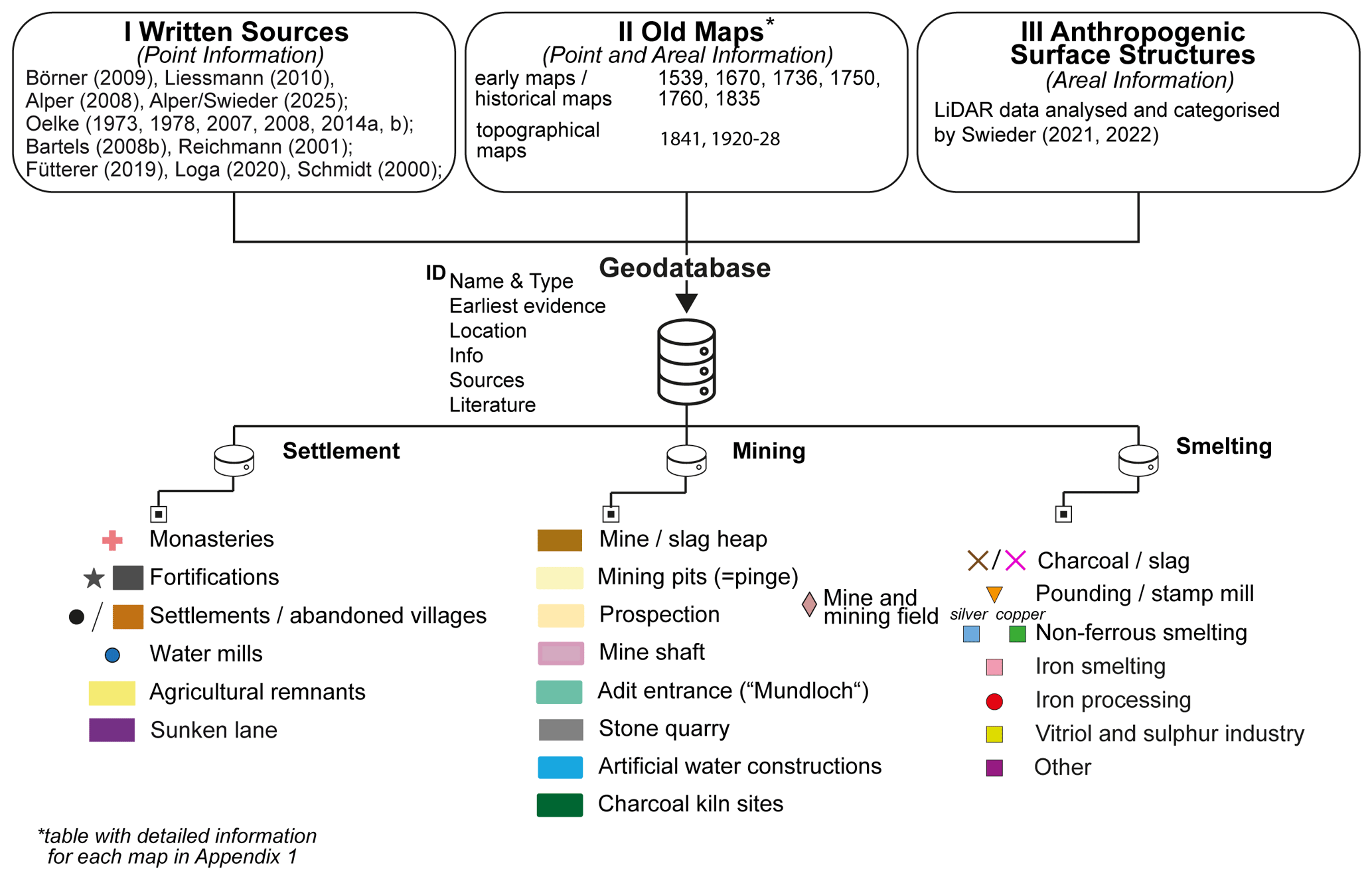
Figure 3Overview of the three different archives and the various sources included therein used to compile the geodatabase of historical and archaeological objects for the study area. The symbology applies to Figs. 5, 6, and 7.
- i.
From modern literature, a database of known historical sites for all three categories – settlement, mining, and smelting – has been compiled (point information). Thus, a catalogue that includes information about names, ages via first mentions or archaeological findings, and (mostly) relative geographic references exists. For individual mines and smelting sites, the regional studies of Oelke (1973, 1978, 2007, 2008, 2014a, b) about the local mining history are of particular interest. This can be extended by studies about individual historical sites, such as those by Bartels (2008b) and Reichmann (2001). The former research focuses on mining activity at Straßberg, especially the Glasebach mine, while the latter concentrates on the smelting works around Mägdesprung. In addition, Börner (2009) and Liessmann (2010) provide an overview of the mining history of the study area and the entire Harz region, respectively. For the initial list of former settlements, monasteries, and fortifications, the historical assessments of medieval settlements by Schmidt (2000) and Fütterer (2019) and the toponomastic analyses of place names by Loga (2020) were used. The study of Fütterer (2019) has the advantage that it already provides coordinates for several medieval sites.
- ii.
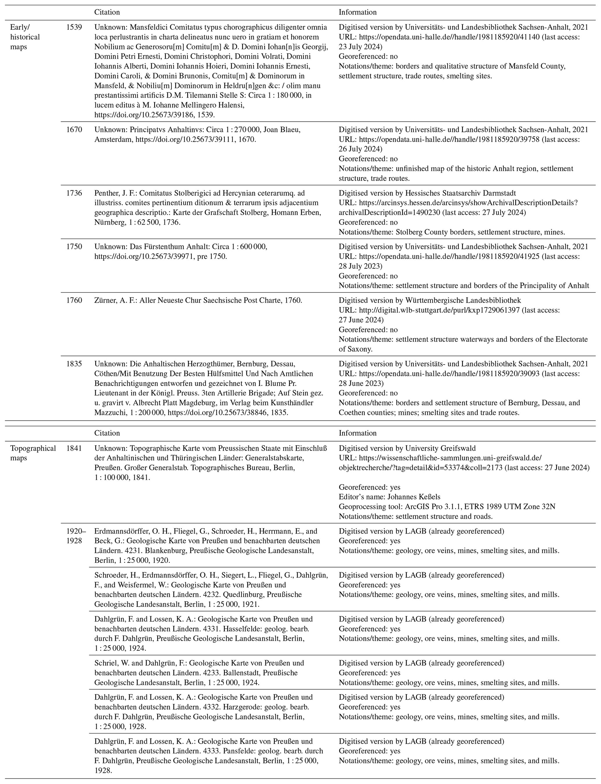
Information from old maps (point and areal information) has been cross-referenced and integrated into the database to enhance completeness and geographic accuracy. Maps representing the complete study area or giving a partial illustration are available dating back to 1539 CE (Fig. 3). For all maps referred to in this study, further information is provided in Table A1. Except for the geological map of Prussia, the old maps cannot be accurately georeferenced and are to be considered more as sketches of the region (Table A1 and Fig. A1). The topographical map of 1841 shows high inaccuracies, especially in the river section downstream of Mägdesprung, where the valley course deviates significantly from the actual relief (see Fig. A1). Therefore, the old maps primarily extend the database by adding temporal information and relative geographic positions to single structures rather than exact coordinates. The map's purpose, whether, for example, to display sovereign borders or postal route networks, also affects its interpretation.
- iii.
The categorised areal anthropogenic surface structures (areal information) are identified and analysed by Swieder (2021, 2022). This dataset is not limited to the surface structures typically associated with mining activity, such as charcoal kiln sites, mining pits, mine shafts, and artificial water constructions. It also includes sunken lanes, agricultural terraces, ridges and furrows, and areas of deserted villages (cf. rectangular icons in Fig. 3).
4.2 Geological/geomorphological data
In a subsequent step, the individual georeferenced digital scans of the geological maps of Prussia and its adjacent German countries (GK 25) covering the study area have been vectorised using ArcGIS Pro 3.1.1. This has resulted in detailed information about the lithology for the whole catchment area being made available at a scale of 1 : 25 000. The primary objectives are threefold: firstly, to identify the presence, locations, and extent of alluvial sediments, fluvial terraces, and peatlands; secondly, to map the several vein structures; and thirdly, to cross-reference these data with the catalogue of the historical sites.
In addition, a relative elevation model (REM) was created to display the height difference between any point in the study area and the nearest river point of the Selke River (see Coe, 2016). Using this kind of terrain representation, channel structures (e.g. oxbow lakes, abandoned channels, mill ponds) and terrace structures can be identified and traced along the river's course, supplementing the information from the geological map. The REM is based on (1) height information from a digital elevation model (DEM) with a 1 m resolution (LVermGeo, 2022) and (2) the course of the Selke River's main channel. For detailed information on the height accuracy of the DEM, refer to the metadata provided by LVermGeo (2022). The main channel is extracted from a calculated river network, which is manually corrected if errors due to bridges, tunnels or artificial water courses occur. All processing steps to calculate the REM are done in ArcGIS Pro 3.1.1 using the Topo to Raster tool for the interpolation and the raster calculator tool to derive the REM raster as the difference between the DEM and the interpolated river height raster.
Based on the modified river network, the hydrological sub-catchments of the study area are delineated. Those sub-catchments are subordinately grouped into the upper catchment (labelled with A), the upper middle catchment (labelled with B), and the lower middle catchment (labelled with C). The further subdivision, preserving the hydrological connectivity, is based on the historical and archaeological data, whether and to what degree mining and smelting activity occurs, whether artificial water constructions like dams modify the river channel, or whether settlement sites indicate intensive land use.
5.1 Geology and ore veins
The geological map in Fig. 4 shows the central vein systems based on the vectorised GK 25 from the 1920s. Spatially, the ore deposits can be divided into the region of the Straßberg–Neudorf Vein (A), the Biwende Vein (B), the Harzgerode district (C, D, E, F) and smaller deposits such as the Brachmannsberg (a) and Erichsburg (b) Vein. Figure 4 also lists the corresponding extracted minerals for the specified veins, with reference to the information provided by the GK 25 and Stedingk et al. (2016). The minerals of primary importance for mining purposes were galena for silver exploration, siderite for iron exploration, chalcopyrite for copper exploration, and pyrite, as well as arsenopyrite for sulfur exploration, in addition to fluorite. However, the mineralisations are not constant with the vein's strike direction but are concentrated in local zones. Superordinately, the fluorspar mineralisation increases to the west of the various vein systems.
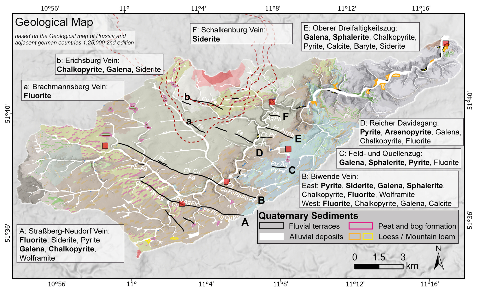
Figure 4Geological map of the study area highlighting the Quaternary sediments and most important ore dykes based on the GK 25 and corresponding main ore minerals based on GK 25 and Stedingk et al. (2016). The large ore veins are labelled with capital letters and small ore veins with small letters. The red rectangles correspond to the cities shown in Fig. 1 and serve as reference points. See Copernicus (2016) for information on the DEM in the background. Projected coordinate system: EPSG: 25832.
Figure 4 highlights the Quaternary sediments in the study area (cf. coloured outlines). Peat and bog formation areas are mapped as potential geoarchives due to organic preservation and are predominantly located at the accumulation zones at the headwaters (cf. Fig. 4). Along the main channel of the Selke River, overbank deposits are mapped upstream of Silberhütte and again further downstream of Mägdesprung (cf. Fig. 4).
5.2 Objects dated pre-1300 CE
Figure 5 displays known settlement structures and records about mining and smelting activity before 1300 CE. The earliest medieval settlements in the study are primarily located in the headwaters of the Selke River and its tributaries, as well as in the plateau areas to the east between Harzgerode and Meisdorf (cf. Fig. 5). The 10th century marks the onset of settlement, with a peak in the 11th and 12th centuries. The slag pieces (S1, S4, S6) and mining pits (M33) are close to some of the settlements, suggesting the possibility of early iron smelting activity that is temporally associated with the settlement periods. The slag piece S5, defined as lead slag, may indicate early silver smelting (10th–12th centuries). The locations S3 and M9 correspond to historical records about bloomeries and silver mines at the Birnbaum site (cf. Sect. 3), likely from the 13th or 14th century. S2 marks the location of the soil profile, at which the charcoal dated to the 7th/8th century was found (cf. Sect. 3).
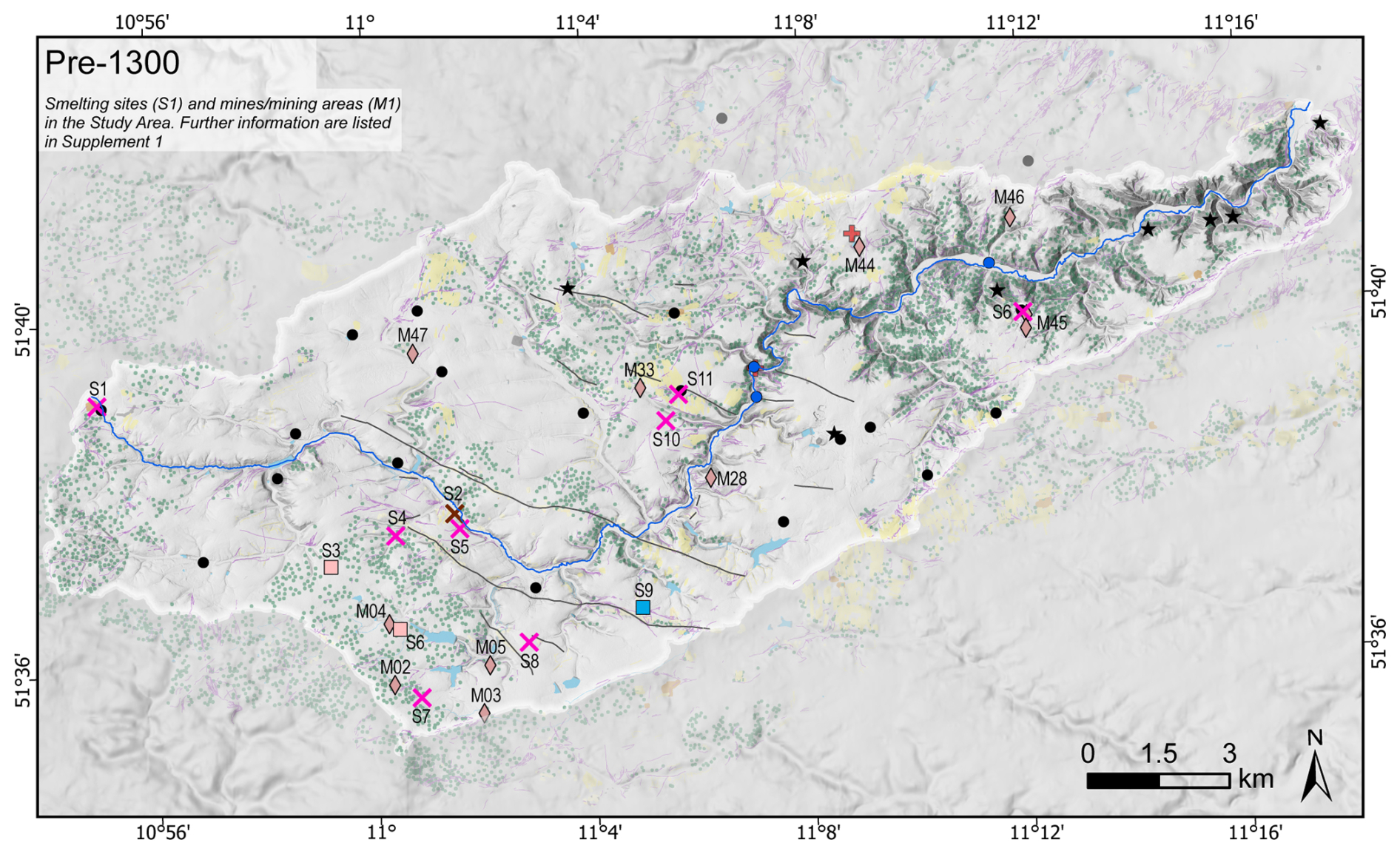
Figure 5Map of mines and smelting sites before 1300 CE. Settlements, monasteries, and fortifications extend this overview. Categorised surface structures are visualised in the background as they do not contain exact age information. The symbology is based on the legend in Fig. 3. Corresponding references are listed in Fig. 3 and Supplement 1. See Copernicus (2016) for information on the DEM in the background. Projected coordinate system: EPSG:25832.
5.3 Objects for 1300 to 1648 CE
Figure 6 shows the catalogued objects between 1300 and 1648 CE. During this period, the number of documented settlements decreased significantly, and the population concentrated in larger settlements (cf. Figs. 5, 6). The earliest historical evidence for almost all mines and smelting sites starts at the beginning of the 15th century. The periods for exploration and operation of the individual mines and smelting sites are not identical and are mainly characterised by temporary works (cf. Supplement 1). Eight smelters are assumed for this period, all located in the valley bottom next to the Selke River, utilising the hydropower. The smelting activity is primarily focused on the extraction of silver. A temporary copper smelter (S17) and a sulfur smelter (S13) are further known.
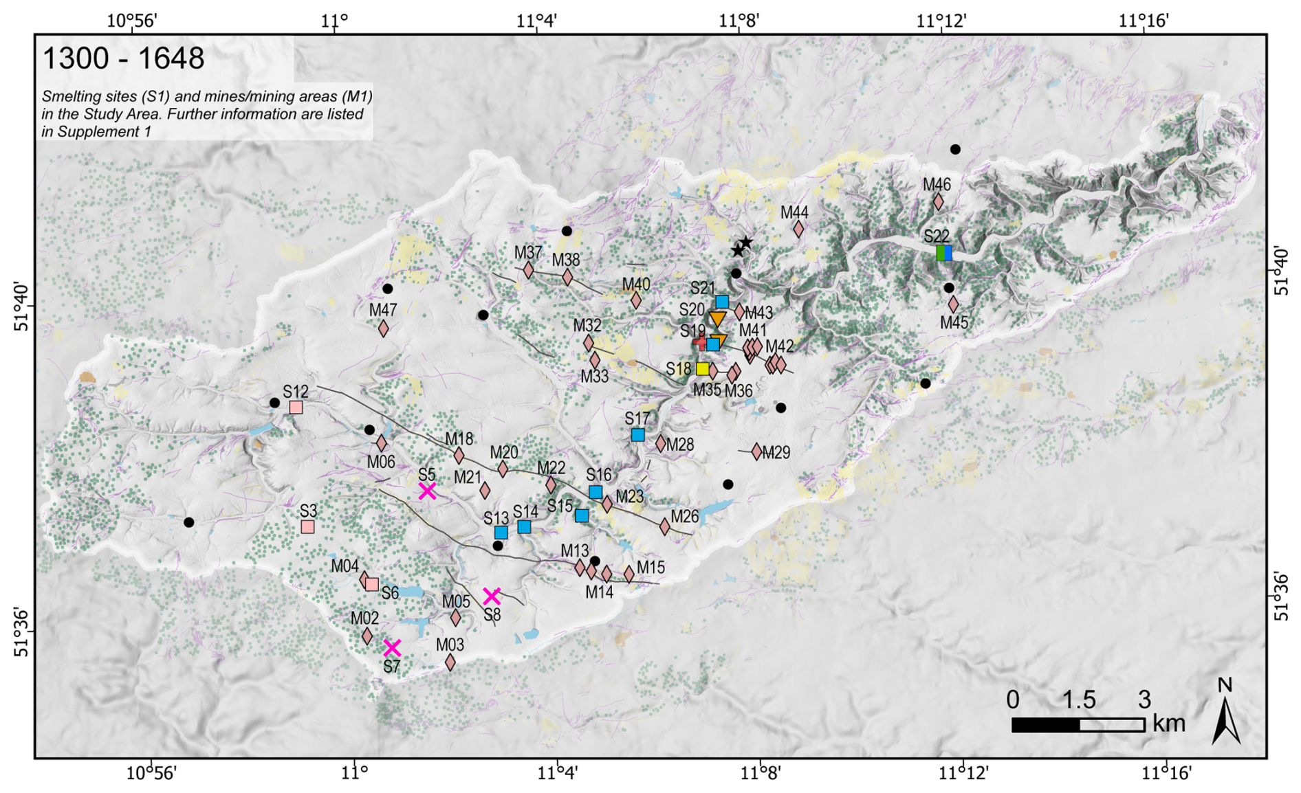
Figure 6Map of mines and smelting sites from 1300 to 1648 CE. Settlements, monasteries, and fortifications extend this overview. The surface structures are visualised in the background as they do not contain exact age information. The symbology is based on the legend in Fig. 3. Corresponding references are listed in Fig. 3 and Supplement 1. See Copernicus (2016) for information on the DEM in the background. Projected coordinate system: EPSG:25832.
5.4 Objects for 1648 to 1990 CE
The Thirty Years' War (1618 to 1648 CE) marked a significant event for the study area as all mines were closed, and smelters were ruinous. Only in the second half of the 17th century were the first mines were re-opened, but with different names (cf. Supplement 1). The locations of the smelters differ in most cases from the time before the Thirty Years' War. Exceptions are the sites S8 and S31 (S16) (cf. Fig. 7). In this period, the three centres for smelting activity developed: Straßberg (mainly silver), Silberhütte (silver, copper, sulfur), and Mägdesprung (iron). The smelting of silver began a few decades later than the smelting of iron, in 1693 and 1646 CE, respectively.
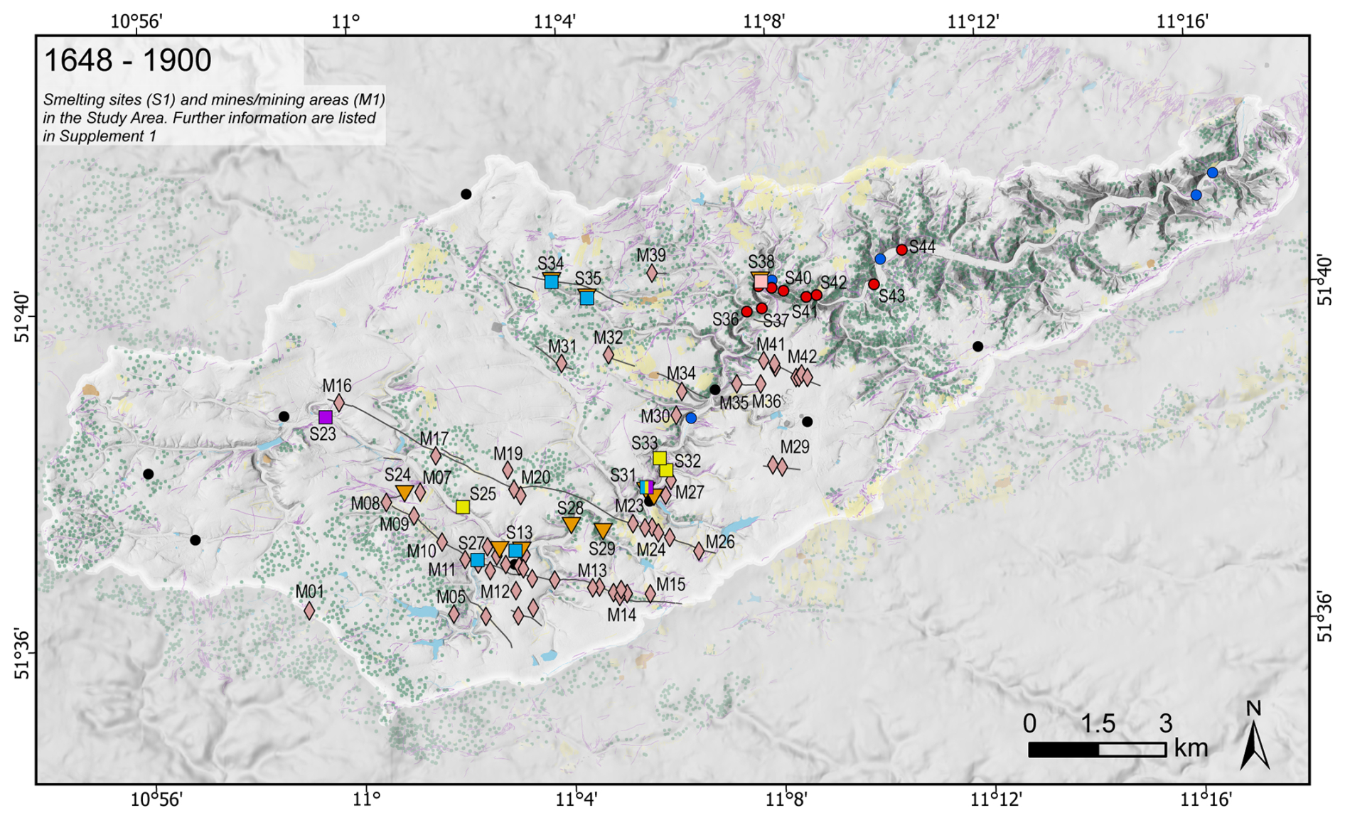
Figure 7Map of mines and smelting sites from 1648 to 1990 CE. Settlements extend this overview. The surface structures are visualised in the background as they do not contain exact age information. The symbology is based on the legend in Fig. 3. Corresponding references are listed in Fig. 3 and Supplement 1. See Copernicus (2016) for information on the DEM in the background. Projected coordinate system: EPSG:25832.
5.5 Relative elevation model and subregions
Figure 8 displays the relief of the whole study area and the hydrological sub-catchments. Especially for the main channel of the Selke River, the REM further visualises the geomorphological characteristics, highlighting present channels and rill structures in dark blue and different floodplain heights in blueish to greenish colours. Compared with the information from the topographic maps about the channel patterns in the study area, changes and constants of river features in the floodplain are visible.
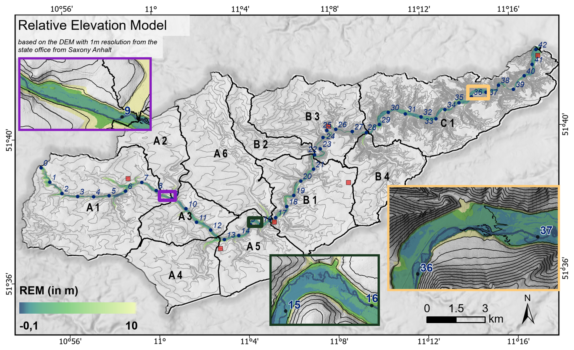
Figure 8Relative elevation model for the main channel of the Selke River, with river kilometres (rkm) and contour lines (20 m). Units A, B, and C represent fluvial subregions of similar geomorphological characteristics and mining history. The three rectangles represent areas of particular interest due to thick alluvial sediments (1) before more intense mining activity started (purple), (2) right after the first mining region around Straßberg (green), and (3) downstream of all known mines and smelting sites (yellow). See Copernicus (2016) for information on the DEM in the background. Projected coordinate system: EPSG:25832.
The 11 sub-catchments represent regions of similar geomorphological characteristics. Superordinately the three central units A, B, and C reflect the change in the dominant valley type. Unit B represents the narrow valley section (cf. Sect. 2), while units A and C are characterised by wider valley bottoms. Linking these sub-catchments with the compiled geodatabase of historical sites, subregions A1, A2, and A6 represent regions of less mining activity. Only a few smelting sites are known, like Selkenfelde (S1). The downstream subregions A3, A4, and A5 are characterised by the mining activity at the Straßberg–Neudorf Vein and Biwende Vein. Subregions A4 and A5 have been further affected by intensive water flow regulations since the beginning of the 18th century (see Schulz, 2012). Subregions B1, B2, B3, and B4 are affected by the mining activity at the Harzgerode veins and the smelting sites around Silberhütte and Mägdesprung. In subregion C1, only little activity is documented, except for mining around Dorf Anhalt and the corresponding smelting site S17.
On that basis, three key areas in the floodplain are identified, representing different land use histories in the upper contributing area. The first area is at the outlet of the two subregions A1 and A2 (Fig. 8 purple rectangle), where previous mining activity was minimal; however, the first mines are located in subregion A3 (see Figs. 5, 6). The second area is between the two smelting sites Straßberg and Silberhütte (Fig. 8 green rectangle). The third area is in subregion C1, just before the Selke River flows out of the Harz Mountains, downstream of all main mining centres (Fig. 8, yellow rectangle).
The maps in Figs. 5, 6, and 7 display the known mines and smelting sites within the study area based on several historical studies. The newly compiled object catalogue prioritises the locations of the objects, the time of the first evidence, exploration or operating phases, and the mined or smelted ores.
It is important to note that many mines and smelters cannot be precisely located. This is because (1) only a few historical records have been proven by archaeological research, (2) while at the same time, it is challenging to assign surface structures with known historical records, and (3) the old maps are not geographically accurate. In addition, remnants of early mining activity have often been overprinted and destroyed by more recent mining periods and renewed exploration activity (Swieder, 2021). Given the limitation of positional accuracy, the objects' coordinates in Supplement 1 are to be understood as approximate locations. However, the spatial location of the mines to the vein systems and the approximate location of the smelters to the Selke River via rkm (river kilometre) and subregion indicate the points at which the respective features may influence the characteristics of the overbank deposits with regard to element concentrations and the presence of slags and/or crushed ores (in German: Pochsande).
The chronological perspective (as illustrated in Figs. 5–7) shows an increase in the number of known mining-related structures. This pattern does not necessarily correlate with the amount of extracted ores but reflects the availability of historical records. Consequently, the mines and smelters should function less as quantitative indicators of the mining intensity but rather as a compendium of known objects on which further work can be systematically built.
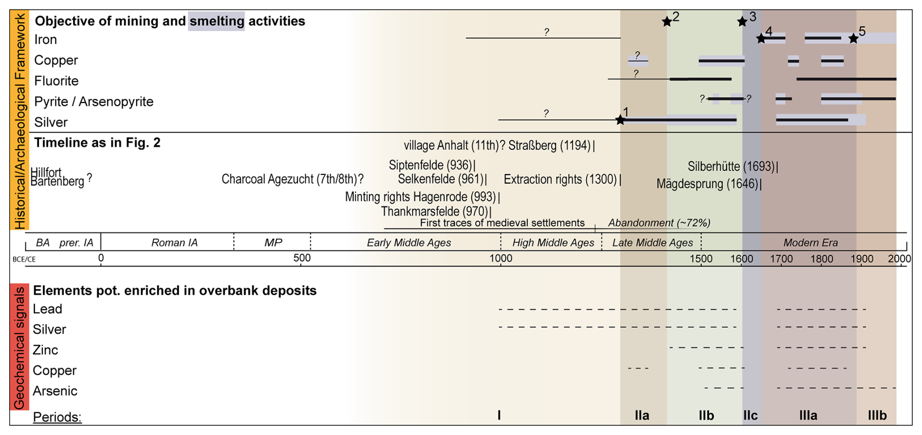
Figure 9Timeline of approximately the last 2000 years, as in Fig. 2, extended by the summary of the mining and smelting activity and possible corresponding element enrichments in overbank deposits. Six periods are distinguished by distinct changes marked with stars 1–5 (see Sect. 6). The labelling with the Roman numerals corresponds to Figs. 5, 6, and 7.
The information in Figs. 5–7 and Supplement 1 are summarised in Fig. 9 by displaying the periods in which iron, copper, fluorite, sulfur, silver mining, or smelting occurred for the whole study area. Early mining appears to have been predominantly focused on iron, copper, and silver ores (cf. Fig. 9).
Zerjadke (2016) addresses whether the onset of fluorite mining was synchronous with copper smelting in the Mansfeld region starting with the beginning of the 12th century. However, current archaeological research does not provide further substantiating evidence for this linkage (Fig. 9).
The extent to which settlement progression in the study area is driven primarily by mining, as observed in the western Harz, or to what degree agricultural purposes additionally accompany it remains uncertain (Bartrow et al., 2021). Archaeological findings from the settlement's vicinity are present for both cases (Swieder, 2022).
During the period spanning from the late Middle Ages to the end of the 17th century, there is an absence of evidence indicative of iron mining. A notable increase in the smelting of sulfurous minerals was observed in the 16th century and, particularly towards the end of the 17th century, coincided with the development of the smelting site Silberhütte.
This study does not incorporate the coal deposits at the northern margin of the Harz Mountains, which were mined during the modern era around Meisdorf, thereby adding another mining-related factor to this region. However, the river catchments affected by this are downstream of rkm 41 (cf. Fig. 8).
Figure 9 lists, in addition to the mined and smelted ores, a selection of elements associated with mining and expected in the Selke River's overbank deposits. Linking the elements that were the target of mining with the elements that are to be expected as a geochemical signal in the floodplains is a simplification and can only serve as a first point of reference for further analysis. The information in Fig. 4 on the primary minerals for the various vein systems, based on Stedingk et al. (2016) and the GK 25, gives reasonable insight. However, changes in element concentrations in the deposit are expected over the mining periods due to the sulfide deposits' internal structuring into the weathered oxidation and cementation zones and the primary ore body (Stöllner, 2003). As a result, ores with higher metal concentrations could have been mined in the early phases of mining (Bartels, 2008b).
The study area's mining history is already divided into distinct periods by Oelke (2014a) and Bartels (2008b). However, their classification focuses on the dominant actors under the control of which mining took place. These actors include individual local centres of power, mining unions, ruling houses, and, in modern times, companies and the state. The mining periods addressed in Fig. 9 (I–IIIb) are less intended to be oriented towards historical political developments but rather to identify periods separated by significant changes in ore mining and/or smelting or historical events, which could potentially be detectable in the floodplain sediments.
Five events that mark transitions in the mining history are chronicled for the periodisation (see Fig. 9). Event *1 is the first explicit historical evidence of mining activity in the study area with the diplomatic record of the mining rights of the Cistercian monasteries (cf. Sect. 3). However, besides this document, there is no further information about the status of already-existing mining activity in this region for that time4 (Börner, 2009; Bartrow et al., 2021). Event *2 marks the first half of the 15th century, to which the first historical evidence of (silver) smelting works directly located at the Selke River dates back (see Fig. 6). At the end of the 16th century (event *3), mining activity decreased significantly, especially for the Straßberg region (Bartels, 2008b); the exact reasons, whether due to weather conditions, reduced metal concentrations, or challenges in the mining process, can only be assumed. With the end of the Thirty Years' War (event *4), mining and smelting works started again (see Fig. 7, Fig. 9). In that period, the first blast furnaces were implemented in the study area: first, in Mägdesprung (1660s CE) (Reichmann, 2001) and later in Straßberg (1717 CE) (Oelke, 1978) and Silberhütte (1720s CE) (Börner, 2009). Event *5 marks the end of the 19th century, when non-ferrous smelting activity decreased and ended at Silberhütte. At the same time, the smelting site Mägdesprung stopped iron smelting works and focused on art casting (see Fig. 9).
Using the REM to visualise the floodplain area enhances the identification of relief structures and the river channel's migration (see Fig. 8). In order to compare these structures with the former channels mapped in the topographic maps, it is important to note that cartographic inaccuracies in terms of the cartographic offset and the abstractness of the signatures do not allow an exact overlay. However, it is possible to compare the relative location of single structures and qualitatively identify the changes. This has been possible for the Selke River catchment for the last 200 years, for which significant human alterations in the river system are already known in the study area. This includes the construction of water ponds and ditches directly associated with the mining activity, mills and mill ditches (see Figs. 5–7; Swieder, 2022), smelting works (see Figs. 5–7), or artificial embankments, for example, along the river section affected by the iron smelting and processing sites related to Mägdesprung (Reichmann, 2001).
In this regard, the three key areas defined in Sect. 5.4 represent floodplain sections that are not directly influenced by human interactions (on-site) but instead represent natural flow and sedimentation dynamics (off-site).
The present study provides a catalogue of extraction sites for iron and non-ferrous metal mining and locations associated with smelting works. Therefore, this study combines mining, smelting, and settlement records and consolidates information from various research studies and archives. To that end, it reflects the current state of scientific research concerning mining history in the Selke River catchment. The spatial representation of the mining and smelting sites for different periods thus constitutes a comprehensive overview of the mining history in the study area. This study hypothesises six mining phases that are traceable in the overbank deposits:
-
Phase I: pre-1300
-
Phase IIa: 1300–1415/1430
-
Phase IIb: 1415/1430–1590s
-
Phase IIc: 1590s–1648
-
Phase IIIa: 1648–1890
-
Phase IIIb: 1890–1990.
Based on the compiled historical and geoarchaeological catalogue and the fluvial geomorphological characteristics, key areas could be differentiated for further geoscientific investigations.
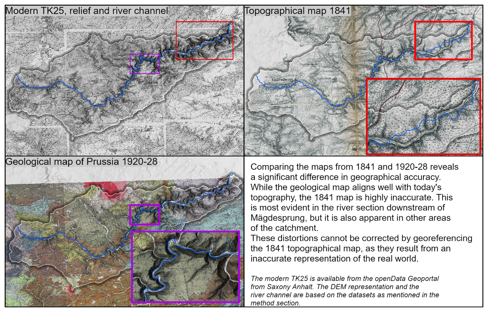
Figure A1Visual comparison of the georeferenced topographical maps.
Table A1List of early/historical maps and topographical maps considered for category II “old maps”. The first two columns refer to the information from Fig. 3.
The compiled dataset in this study of historical mining and smelting sites is available in the Supplement. The underlying dataset of anthropogenic surface structures is published in Swieder (2022). The analysed digital elevation model is freely available via the open geodata portal of Saxony-Anhalt (LVermGeo, 2022). The georeferenced geological maps of Prussia covering the study area were kindly provided by the Landesamt für Geologie und Bergwesen Sachsen-Anhalt (LAGB). For access to the underlying data sets please refer to the respective copyright holders as mentioned above.
The supplement related to this article is available online at https://doi.org/10.5194/egqsj-74-129-2025-supplement.
Conceptualisation: JK, AS, PS, FL; methodology: JK, PS; data collection and analysis: JK, AS, CT, GA; writing – original draft preparation: JK, AS, PS; writing – review and editing: FL, AS, PS, GA, SF; visualisation: JK; supervision: FL, SF, PS. All authors read and approved the final manuscript.
At least one of the (co-)authors is a guest member of the editorial board of E&G Quaternary Science Journal for the special issue “Floodplain architecture of fluvial anthropospheres”. The peer-review process was guided by an independent editor, and the authors also have no other competing interests to declare.
Publisher's note: Copernicus Publications remains neutral with regard to jurisdictional claims made in the text, published maps, institutional affiliations, or any other geographical representation in this paper. While Copernicus Publications makes every effort to include appropriate place names, the final responsibility lies with the authors.
This article is part of the special issue “Floodplain architecture of fluvial anthropospheres”. It is not associated with a conference.
We thank Hannah Schulten and Robin Felder for their assistance in the literature review and handling of the GIS data. The digital elevation model of the study area was made available by the Landesamt für Vermessung und Geoinformation Sachsen-Anhalt (DGM1 © GeoBasis-DE/LVermGeo LSA, Datenlizenz Deutschland – Namensnennung – Version 2.0).
The authors thank the German Research Foundation (DFG) for funding the project.
This research has been supported by the Deutsche Forschungsgemeinschaft (grant no. 509913955).
This open-access publication was funded by the RWTH Aachen University.
This paper was edited by Christoph Zielhofer and reviewed by two anonymous referees.
Alper, G.: The Eastern Harz Mountains during the Middle Ages – the Impact of Mining and Metal Production, in: Cultural heritage and landscapes in Europe: Proceedings of the international conference, Bochum, 8–10 June 2007, edited by: Bartels, C., Deutsches Bergbau-Museum, Bochum, 467–488, ISBN 978-3-937203-36-2, 2008.
Alper, G.: Archäologische Untersuchungen zur Eisen- gewinnung am “Kleinen Schmidtskopf” bei Elbingerode, Lkr. Harz, Jahresschrift für mitteldeutsche Vorgeschichte, 201–242, https://doi.org/10.11588/jsmv.2016.0.70634, 2016.
Alper, G. and Swieder, A.: Mittelalterliche Verhüttung im Unterharz, Festschrift Olaf Kürbis. Archäologie in Sachsen-Anhalt, Sonderband, in preparation, 2025.
Asmus, B.: The Harz Mountains and some thoughts on the copper trade, in: Cuivres, bronzes et laitons médiévaux: Actes du colloque de Dinant et Namur, 15–17 mai 2014, edited by: Thomas, N. and Dandridge, P., Agence wallonne du Patrimoine, Namur, 25–35, ISBN 9782390380160, 2018.
Bartels, C.: Bergbau und Münzstätten im Harz, in: Interdisziplinäre Tagung zur Geschichte der neuzeitlichen Metallgeldproduktion 1. Projektberichte und Forschungsergebnisse. Beiträge zur Tagung in Stolberg (Harz), April 2006, edited by: Cunz, R., Dräger, U., and Lücke, M., Braunschweig, 23–50, https://doi.org/10.24355/DBBS.084-201304231034-0, 2008a.
Bartels, C.: Die Grube Glasebach und der Bergbau bei Straßberg im östlichen Harz, in: Abhandlungen der Braunschweigischen Wissenschaftlichen Gesellschaft, Interdisziplinäre Tagung zur Geschichte der neuzeitlichen Metallgeldproduktion 1, Projektberichte und Forschungsergebnisse, Stolberg (Harz), April, 51–69, https://doi.org/10.24355/DBBS.084-201304231045-0, 2008b.
Bartrow, A., Gärtner, T., and Rösch, F.: Burgen, Dörfer und Pingen: Spuren des Landesausbaus im Unterharz, Mitteilungen der Deutschen Gesellschaft für Archäologie des Mittelalters und der Neuzeit, 33, 217–230, https://doi.org/10.11588/dgamn.2020.0.77906, 2021.
Börner, K.-H.: Bergwerke und Hütten in der Harzgeröder Region unter besonderer Berücksichtigung der Mägdesprunger Eisenhütte, Mägdesprunger Hefte, 2, Harzgerode, 80 pp., ISBN 978-3-937648-16-3, 2009.
Brachmann, H.: Der Harz als Wirtschaftsraum des frühen Mittelalters, Zeitschr. Harz-Ver. Gesch. u. Altkde., 124/125, 7–25, 1992.
CDA II: Codex diplomaticus Anhaltinus II: 1212–1300, edited by: von Heinemann, O., Dessau, 1875.
Coe, D. E.: Floodplain visualization using lidar-derived relative elevation models, Poster presented at DigitalMapping Techniques 2016, https://ngmdb.usgs.gov/Info/dmt/docs/DMT16_Coe.pdf (last access: 13 August 2025), 2016.
Copernicus: European Digital Elevation Model (EU-DEM) verson 1.1, EEA [data set], https://sdi.eea.europa.eu/catalogue/srv/api/records/d08852bc-7b5f-4835-a776-08362e2fbf4b (last access: 13 August 2025), 2016.
Denecke, D.: Die Besiedlung des Westharzes – ein Bericht über jüngere Forschungen zum Bergbau, in: Siedlungsforschung, Archäologie-Geschichte-Geographie, edited by: Fehn, K., Bender, H., Brandt, K., Denecke, D., Irsigler, F., Janssen, W., Krings, W., Müller-Wille, M., Nitz, H.-J., Oberbeck, G., and Schich, W., Siedlungsforschung, Bonn, 163–171, https://www.uni-bamberg.de/histgeo/vernetzung/arkum/zeitschrift-siedlungsforschung/ (last access: 18 August 2025), 1992.
D O III: Ottonis III. Diplomata. Monumenta Germaniae Historica. Diplomatum Regum et Imperatorum Germaniae II, edited by: von Sickel, T., Hannover, 1893.
Dobler, L.: Der Einfluss der Bergbaugeschichte im Ostharz auf die Schwermetalltiefengradienten in historischen Sedimenten und die fluviale Schwermetalldispersion in den Einzugsgebieten von Bode und Selke im Harz, Dissertation, Martin-Luther-Universität Halle-Wittenberg, Halle, https://doi.org/10.25673/3382, 1999.
Friedel, C.-H., Huckriede, H., Leiss, B., and Zweig, M.: Large-scale Variscan shearing at the southeastern margin of the eastern Rhenohercynian belt: a reinterpretation of chaotic rock fabrics in the Harz Mountains, Germany, Int. J. Earth Sci. (Geol. Rundsch.), 108, 2295–2323, https://doi.org/10.1007/s00531-019-01763-1, 2019.
Fütterer, P.: GIS als Hilfsmittel zur Analyse räumlicher Strukturen im östlichen Sachsen und Thüringen des 10. und frühen 11. Jahrhunderts: Eine Königslandschaft neu betrachtet, Das Mittelalter, 24, 91–111, https://doi.org/10.1515/mial-2019-0007, 2019.
Gärtner, T. and Rösch, F.: Burg und Dorf Anhalt – neue Erkenntnisse der Archäologie, Mitteilungen des Vereins für Anhaltische Landeskunde, 28, 9–40, 2019.
Graaf, S. de, Lüders, V., Banks, D. A., Sośnicka, M., Reijmer, J. J. G., Kaden, H., and Vonhof, H. B.: Fluid evolution and ore deposition in the Harz Mountains revisited: isotope and crush-leach analyses of fluid inclusions, Miner. Deposita, 55, 47–62, https://doi.org/10.1007/s00126-019-00880-w, 2020.
Gringmuth-Dallmer, E.: Die mittelalterliche Besiedlung des Mittel- und Unterharzes, in: Siedlungsforschung, Archäologie-Geschichte-Geographie, edited by: Fehn, K., Bender, H., Brandt, K., Denecke, D., Irsigler, F., Janssen, W., Krings, W., Müller-Wille, M., Nitz, H.-J., Oberbeck, G., and Schich, W., Bonn, 145–161, ISBN 978-3-540-31327-4, 1992.
Heckl, J.: Untersuchungen zu Münzstätten in und bei Harzgerode 1. Mittelalter, Geldgeschichtliche Nachrichten, 193, 283–292, 1999.
Klappauf, L.: Silber und Kupfer aus dem Harz, Praehistorica, 31, 635–654, 2014.
Klappauf, L., Linke, F.-A., and Schröpfer, T.: Montanarchäologie im westlichen Harz, Nachrichten aus Niedersachsens Urgeschichte, 66, https://doi.org/10.11588/nnu.1997.1.47783, 1997.
Knapp, H., Robin, V., Kirleis, W., and Nelle, O.: Woodland history in the upper Harz Mountains revealed by kiln site, soil sediment and peat charcoal analyses, Quatern. Int., 289, 88–100, https://doi.org/10.1016/j.quaint.2012.03.040, 2013.
Liessmann, W.: Historischer Bergbau im Harz, Springer Berlin Heidelberg, Berlin, Heidelberg, 473 pp., https://doi.org/10.25673/90708, 2010.
Loga, K.: Ortsnamen im Ostharz. Eine onomastische Untersuchung der Namen rezenter und wüst gefallener Siedlungen der ehemaligen Landkreise Sangerhausen und Quedlinburg, Dissertation, Martin-Luther-Universität Halle-Wittenberg, Halle, 626 pp., https://doi.org/10.25673/90708, 2020.
LVermGeo: DGM1 mit einer Rasterweite von 1 m, Landesamt für Vermessung und Geoinformation Sachsen-Anhalt, LVermGeo [data set], https://www.lvermgeo.sachsen-anhalt.de/de/gdp-dgm1-landesweit.html (last access: 9 April 2024), 2022.
Manganaro, S.: Netzwerke in der Ottonenzeit, Quellen und Forschungen aus italienischen Archiven und Bibliotheken, 100, 137–179, https://doi.org/10.1515/qufiab-2020-0011, 2020.
Matschullat, J., Ellminger, F., Agdemir, N., Cramer, S., Ließmann, W., and Niehoff, N.: Overbank sediment profiles – evidence of early mining and smelting activities in the Harz mountains, Germany, Appl. Geochem., 12, 105–114, https://doi.org/10.1016/S0883-2927(96)00068-6, 1997.
Mohr, K.: Geologie und Minerallagerstätten des Harzes, Schweizerbart, Stuttgart, 387 pp., ISBN 3510650824, 1978.
Monna, F., Hamer, K., Lévêque, J., and Sauer, M.: Pb isotopes as a reliable marker of early mining and smelting in the Northern Harz province (Lower Saxony, Germany), J. Geochem. Explor., 68, 201–210, https://doi.org/10.1016/S0375-6742(00)00005-4, 2000.
Oelke, E.: Der Bergbau im ehemals anhaltischen Harz: Ein Überblick, Hercynia N. F., 10, 77–95, 1973.
Oelke, E.: Die Silbergewinnung im ehemals stolbergischen Harz, Hallenser Jahrbuch für Geowissenschaften, 3, 24 pp., https://doi.org/10.25673/91956, 1978.
Oelke, E. and Hebestedt, E.: Alte Hütten an der Selke, Der Anschnitt, 59, 191–203, 2007.
Oelke, E.: Der frühe Bergbau im anhaltinischen Harz, Der Anschnitt, 60, 133–151, 2008.
Oelke, E.: Der Bergbau im anhaltinischen Harz – ein Überblick, in: Proceedings of the Regionalgeschichtliche Tagung, Der anhaltische Harz als Kulturraum, Harzgerode, 02.07.2011 and 14.07.2012, 142–163, ISBN 9783940744579, 2014a.
Oelke, E.: Die frühen Hütten im anhaltinischen Harz, in: Proceedings of the Regionalgeschichtliche Tagung, Der anhaltische Harz als Kulturraum, Harzgerode, 02.07.2011 and 14.07.2012, 164–180, ISBN 9783940744579, 2014b.
Parker, A. J., Milan, D. J., and McEwen, L. J.: Correlating floodplain geochemical profiles with archival historical mining records to establish depositional chronologies of river sediment, CATENA, 218, 106532, https://doi.org/10.1016/j.catena.2022.106532, 2022.
Reichmann, M.: Die Harzer Eisenhütte unterm Mägdesprung. Ein Beitrag zum Kunstguss im Nordharz, Dissertation, Martin-Luther-Universität Halle-Wittenberg, Leipzig, 302 pp., ISBN 978-3-8258-6194-0, 2001.
Robin, V., Knapp, H., Bork, H.-R., and Nelle, O.: Complementary use of pedoanthracology and peat macro-charcoal analysis for fire history assessment: Illustration from Central Germany, Quatern. Int., 289, 78–87, https://doi.org/10.1016/j.quaint.2012.03.031, 2013.
Schmidt, B.: Zur Besiedlung des Unterharzes in frühgeschichtlicher Zeit und im Mittelalter, in: Anhaltischer Harz: Profile und Kultur einer historischen Landschaft vom Hochmittelalter bis zum 19. Jahrhundert, edited by: Römer, C., Lucas Verlag, Berlin, 17–28, 2000.
Schmidt-Wygasch, C., Schamuhn, S., Meurers-Balke, J., Lehmkuhl, F., and Gerlach, R.: Indirect dating of historical land use through mining: Linking heavy metal analyses of fluvial deposits to archaeobotanical data and written accounts, Geoarchaeology, 25, 837–856, https://doi.org/10.1002/gea.20334, 2010.
Schulz, G.-G.: Die Wasserwirtschaft des Straßberger Reviers (Ostharz) im 18. und 19. Jahrhundert, Der Anschnitt, 64, 172–177, 2012.
Stedingk, K.: Bilanz und Perspektiven der Harzer Erzlagerstättenforschung. Fakten und Schlussfolgerungen, in: Bilanz und Perspektiven der Harz-Forschung: 150 Jahre Harz-Verein für Geschichte und Altertumskunde Dokumentation der Tagung zum hundertfünfzigjährigen Bestehen des Harz-Vereins für Geschichte und Altertumskunde im Rathaus Wernigerode am 22. und 23. Juni 2018, edited by: Juranek, C. and Knolle, F., Lukas Verlag, Berlin, 24–91, ISBN 978-3-86732-337-6, 2021.
Stedingk, K., Ließmann, W., and Bode, R.: Harz: Bergbaugeschichte, Mineralienschätze, Fundorte, Bode Verlag, Salzhemmendorf, 804 pp., ISBN 978-3-942-588-16-4, 2016.
Steingräber, L. F., Ludolphy, C., Metz, J., Germershausen, L., Kierdorf, H., and Kierdorf, U.: Heavy metal concentrations in floodplain soils of the Innerste River and in leaves of wild blackberries (Rubus fruticosus L. agg.) growing within and outside the floodplain: the legacy of historical mining activities in the Harz Mountains (Germany), Environ. Sci. Pollut. R., 29, 22469–22482, https://doi.org/10.1007/s11356-021-17320-w, 2022.
Stöllner, T.: Mining and economy: a discussion of spatial organisations and structures of early raw material exploitation, in: Man and Mining – Mensch und Bergbau: Studies in honour of Gerd Weisgerber on occasion of his 65th birthday, edited by: Stöllner, T., Körlin, G., Steffens, G., and Cierny, J., Deutsches Bergbau-Museum, Bochum, 415–446, ISBN 3-921533-98-8, 2003.
Swieder, A.: Per Laserstrahl durchs Selketal. Landschaftsarchäologische Untersuchungen mittelalterlicher und frühneuzeitlicher Bodendenkmale im Ostharz anhand digitaler Geländedaten, Jahresschrift für mitteldeutsche Vorgeschichte, 98, 379–460, https://doi.org/10.11588/jsmv.2021.1.81486, 2021.
Swieder, A.: Archiv Wald – Studien zur Geschichte der Land- und Ressourcennutzung im östlichen Harz auf der Basis digitaler Geländedaten: Band 1, Dissertation, Martin-Luther-Universität Halle-Wittenberg and Landesmuseum für Vorgeschichte, ISBN 3-948618-46-1, 2022.
Thietmar: Die Chronik des Bischofs Thietmar von Merseburg und ihrer Korveier Überarbeitung, Monumenta Germaniae Historica: Sriptores IX., edited by: Holtzmann, R., Berlin, 1935.
Werther, L., Mehler, N., Schenk, G. J., and Zielhofer, C.: On the Way to the Fluvial Anthroposphere – Current Limitations and Perspectives of Multidisciplinary Research, Water, 13, 2188, https://doi.org/10.3390/w13162188, 2021.
Widukind: Die Sachsengeschichte des Widukind von Korvei, Monumenta Germaniae Historica.: SS rer. Germ. LX., edited by: Hirsch, P., Hannover, 1935.
Zerjadke, W.: Der Bergbau auf Flussspat im Unterharz, in: Zur Industriegeschichte im Südharz, edited by: Grönke, H.-J., Lukas Verlag, Berlin, Wernigerode, 138–196, ISBN 978-3-86732-223-2, 2016.
It is an ongoing discussion among historians whether these minting rights were granted to Hagenrode itself or to the nearby settlement of Harzgerode. For further information refer to Swieder (2022) and references therein.
Slag findings listed as evidence for smelting processes may in individual cases be smithing slags resulting from either forging or metallurgical processes.
This category includes information from Ortsakten (OA) from the LDA archive, where archaeological findings for defined regions are documented.
The historical records from Widukind (1935, III, 62) and Thietmar (1935, II, 13) for the 10th century indicate early silver mining in the Harz Mountains, but a clear geographical reference cannot be established with certainty (see Bartels, 2008a, and Swieder, 2022).
- How to cite
- Abstract
- Kurzfassung
- Introduction
- Study area
- Overview of the study area's mining history
- Methods
- Results
- Discussion
- Conclusions
- Appendix A: Early/historical maps and topographical maps
- Data availability
- Author contributions
- Competing interests
- Disclaimer
- Special issue statement
- Acknowledgements
- Financial support
- Review statement
- References
- Supplement