the Creative Commons Attribution 4.0 License.
the Creative Commons Attribution 4.0 License.
 | 23 Oct 2025
Late Quaternary geomorphological processes and landscape evolution in the Khur Basin, central Iran
Zakieh Rashidi Koochi
Christian Büdel
Janek Walk
Markus Fuchs
Mehdi Torabi
Alireza Karimi
Roland Baumhauer
Georg Stauch
Rashidi Koochi, Z., Büdel, C., Walk, J., Fuchs, M., Torabi, M., Karimi, A., Baumhauer, R., and Stauch, G.: Late Quaternary geomorphological processes and landscape evolution in the Khur Basin, central Iran, E&G Quaternary Sci. J., 74, 193–212, https://doi.org/10.5194/egqsj-74-193-2025, 2025.
The interior of the Central Iranian Plateau is an important area for the study of the palaeoenvironmental controls of early human dispersal in arid regions. In the now hyper-arid region, human migrations may have been affected by the major Quaternary climatic changes. However, due to the difficult access and harsh climate in the central desert, there are scarce palaeoenvironmental data available to reconstruct the interplay between migration of past cultures and environmental change. In the Khur Basin, located in the central part of the Iranian Plateau and on the eastern edge of the central Great Kavir, geomorphological landscape archives have been preserved that provide valuable information about the landscape evolution and climate dynamics of this characteristic desert region. As the spatiotemporal relationships between the dominant geomorphological forms and processes in this area have mostly been studied in isolation, this study adopted an integrative approach to better assess the diverse interactions. This involved geomorphological mapping and detailed field-based geomorphological and stratigraphical analyses of 12 sedimentary sequences distributed over eight geomorphic units of the Khur Basin. The resulting relative chronological classification of the morphostratigraphy suggests a logical sequence of six main phases of landscape evolution. By combining our mapping results with dated geoarchives of the region, a tentative chronology was developed. The early stages as observed in the stratigraphically oldest preserved landforms were characterised by a sequence of different processes, including pediment erosion, alluvial fan and dune formation, and soil development, and probably date to the phase before and during Marine Isotope Stage (MIS) 3. The subsequent landforms and deposits are to be interpreted as a result of alluvial fan progradation into the basin interior as well as dune development, which are probably attributable to the cold and arid conditions during the Last Glacial Maximum (LGM). The most recent morphostratigraphic findings correlate with the combined effects of pedological and geomorphological processes, including the formation of gypsum-rich soils, sand dune reactivation, and the deflation of playa surfaces. These findings indicate an increasing aridity in the area, which is often associated with the climatic development of the Holocene. Through the systematic integration of stratigraphical and geomorphological evidence, this study provides a first comprehensive historical–genetic model of landscape evolution in the Khur Basin.
Paläoökologische Veränderungen im Inneren des zentraliranischen Plateaus hatten großen Einfluss auf die frühe Ausbreitung des Menschen. Während die Region heutzutage hyperarid ist, könnten feuchtere Klimabedingungen während des Quartärs die Wanderungsrouten beeinflusst haben. Aufgrund der Abgeschiedenheit der Region und des rauen Klimas in der zentralen Wüste sind jedoch nur wenige paläoökologische Daten verfügbar, anhand derer sich die Wechselwirkungen zwischen der Migration vergangener Kulturen und den Umweltveränderungen rekonstruieren ließen. Im Khur-Becken, das sich im zentralen Teil des iranischen Plateaus und am östlichen Rand des zentralen Großen Kavir befindet, haben sich geomorphologische Landschaftsarchive erhalten, die wertvolle Informationen über die Entwicklung und Klimadynamik dieser charakteristischen Wüstenregion liefern. Da die raum-zeitlichen Beziehungen zwischen den dominierenden geomorphologischen Formen und Prozessen in diesem Gebiet bisher meist isoliert untersucht wurden, wurde in dieser Studie ein integrativer Ansatz gewählt, um gerade die vielfältigen Wechselwirkungen besser bewerten zu können. Die Untersuchungen umfassten sowohl detaillierte geomorphologische Kartierungen als auch die geomorphologische und stratigraphische Aufnahme von zwölf Sedimentsequenzen, die sich auf acht verschiedene geomorphologische Einheiten des Khur-Beckens verteilen. Die daraus resultierende relative Chronologie ermöglicht die Identifizierung von sechs Hauptphasen der Landschaftsentwicklung. In Kombination mit bereits datierten Geoarchiven der Region konnte die Landschaftsentwicklung zeitlich eingegrenzt werden. In einer ersten Phase kam es im Khur-Becken zur Erosion der Pedimente am Rande der Gebirgsketten. Zudem bildeten sich ausgedehnte Schwemmfächer und erste Dünen. An verschiedenen Stellen gibt es Hinweise auf Bodenbildung. Diese Prozesse erfolgten wahrscheinlich bis zum Ende des MIS 3. Unter den kalten und trockenen Bedingungen des LGM kam es zur Progradation der Schwemmfächer ins Beckeninnere sowie zu ausgedehnter Dünenbildung. Im Holozän kam es zur Deflation der Playaflächen, zur Reaktivierung von Dünen und zur Bildung von gipsreichen Böden. Mithilfe der systematischen Integration stratigraphischer und geomorphologischer Analysen konnte im Rahmen dieser Studie ein erstes historisch-genetisches Modell der Landschaftsentwicklung im Khur-Becken erstellt werden.
- Article
(6224 KB) - Full-text XML
- BibTeX
- EndNote


The Iranian highland is part of the Alpine–Himalayan orogenic belt, which hosts a complex landscape (Maghsoudi, 2021). Today the region is hyper-arid. However, previous research indicates significant palaeoenvironmental variations during the Pleistocene and the Holocene (e.g. Hamzeh et al., 2016; Kirsten et al., 2023). This is especially important as the region serves as a crucial migratory connection, linking Europe and Central Asia (Armitage et al., 2011; Groucutt et al., 2021). Central Iran was presumably important for human dispersal and human trade routes during more humid periods (Nasab et al., 2013; Shoaee et al., 2023) as already indicated for other regions in western Asia (Breeze et al., 2015; Delagnes et al., 2012). Yet it remains unclear when these routes were active and how their usages were related to climate changes (Shoaee et al., 2023).
Over the past decades, there has been growing interest in understanding past environmental changes in western Asia. However, environmental investigations in Iran are mostly focused on the continuous lake archives of western Iran (e.g. Djamali et al., 2008; Jones et al., 2014; Saeidi Ghavi Andam et al., 2021; Sari et al., 2024; Sharifi et al., 2015; Stevens et al., 2006; Wasylikowa et al., 2006) and north-northeastern loess–palaeosol archives (Karimi et al., 2011; Kehl et al., 2021; Vlaminck et al., 2016). These archives offer insights into palaeoclimatic development due to their continuous development and long-time, high-resolution stratigraphic record. Increasing evidence indicates that climate changes in western Asia during the late Pleistocene–Holocene were related to obliquity and precession-controlled cycles of the Northern Hemisphere (Mehterian et al., 2017, Roberts et al., 2018). Some sparse but valuable efforts have been undertaken to highlight the landscape and palaeoenvironmental development of the Iranian highlands including their alluvial fans and river terraces (e.g. Arzani and Jones, 2018; Bayat et al., 2018; Büdel et al., 2017; Büdel, 2020; Khosravichenar et al., 2020; Walker and Fattahi., 2011), floodplains (Busch et al., 2024), playa and playa lakes (e.g. Büdel, 2020; Jones et al., 2014; Pourali et al., 2023; Rahimpour-Bonab and Abdi, 2012; Torabi et al., 2023; Vaezi et al., 2019), sand dunes (Rahimzadeh et al., 2019), and soil carbonates (Bayat et al., 2023). Despite that, our understanding of geomorphological archives and landscape evolution of the vast Iranian highlands remains vague and incomplete (Kehl, 2009). Concurrently, there is a deficit in the comprehension of the spatiotemporal relationships between the dominant geomorphological processes that have so far mostly been investigated in isolation. Therefore, there is a high demand for the consolidation and integration of further palaeoclimatic archives with their geomorphic interrelations and for the evaluation of new types of geoarchives from landscape elements that are more common and characteristic for the extreme environments of central Iran.
The Great Central Desert or Great Kavir, the largest salt desert in Iran, is located at the centre of the Iranian Plateau and extends to the eastern part of Iran (Jackson et al., 1990; Krinsely, 1970). Various geomorphological features constitute the primary components of the landscape in the Great Kavir, including fluvial landforms such as alluvial fans and pediments, aeolian features like deflation pans, sand dunes, and ergs, and composite landforms such as desert pavements. However, the preservation of organic material in such hyper-arid environments is generally very poor, as demonstrated in other desert regions (e.g. Dunseth et al., 2017). Additionally, many archives in dry areas are discontinuous (e.g. Stauch, 2016; Bartz et al., 2020), resulting in further challenges in the interpretation. The Great Kavir, from the geoarchaeological perspective, has hosted numerous historic and prehistoric settlements situated along the alluvial fans and fringes of playa lakes spanning from the Pleistocene to the Holocene periods (Maghsoudi et al., 2019). Formation patterns and the dynamics of the settlements indicate the profound dependence of the prehistoric desert inhabitants on geomorphological conditions and environmental changes (Maghsoudi, 2021; Nasab et al., 2013).
The fact that for this part of the Iranian Plateau only limited data on stratigraphy and landscape evolution are available can primarily be attributable to challenging accessibility and harsh climatic conditions (Walker and Fattahi, 2011). The Khur Basin (Fig. 1) is located in the southeastern edge of the Great Kavir. Our objective was to establish an initial outline of the late Quaternary geomorphological and sedimentological archives of the basin. This will (i) offer insights regarding distinctive landforms (geomorphic positions) and their sediments and (ii) represent the first step towards understanding the interrelation and relative order of the dominant landscape-shaping processes and their relation to palaeoclimatic evolution. The role of palaeoclimate change in landscape evolution is critical. A thorough understanding of palaeoclimate history strongly relies on accurate and precise age control (Sirocko, 2007). Since we have no direct chronological controls on the Khur Basin archive, we compare the observed field evidence with other analogous palaeoclimate records from the Iranian Plateau. This comparative approach provides a first picture of landscape evolution during the late Quaternary. This facilitates a better understanding of the contribution of palaeoenvironmental conditions and landscape evolution to the establishment of the Old World Dry Belt and human trade routes (Kehl et al., 2023; Rashidi et al., 2019; Shoaee et al., 2023).
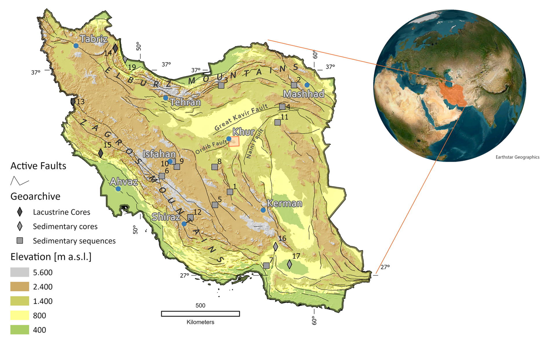
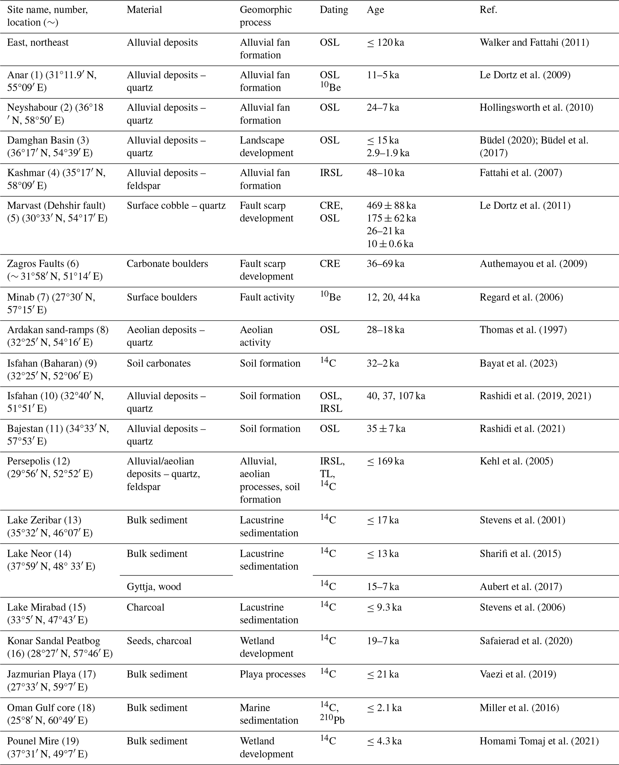
Figure 1Study area (own map; data: GTOPO30 DEM; ESRI ArcScene). 1 – Anar; 2 – Neyshabour; 3 – Damghan Basin; 4 – Kashmar; 5 – Marvast (Dehshir fault); 6 – Zagros Faults; 7 – Minab; 8 – Ardakan sand-ramps; 9 – Isfahan (Baharan); 10 – Isfahan; 11 – Bajestan; 12 – Persepolis; 13 – Lake Zeribar; 14 – Lake Neor; 15 – Lake Mirabad; 16 – Konar Sandal Peatbog; 17 – Jazmurian Playa; 18 – Oman Gulf core; 19 – Pounel Mire.
The study area of Khur is situated 40 km southeast of the city of Khur and at the easternmost border of Isfahan province and in the southeastern part of the Great Kavir (Fig. 1). The area of the Khur Basin is 120 km2 with an average altitude of 800 m above sea level. The lowest point (playa) is about 700 m above sea level, and the highest peaks reach above 1400 m.
The activity of the major Eurasian synoptic systems including the Siberian anticyclone, midlatitude westerlies (MLWs), and the Indian summer monsoon (ISM) impacts western Asia and particularly the Central Iranian Plateau. The convergence of these systems has controlled the climate conditions of the plateau since the late Pleistocene (Hamzeh et al., 2016; Mehterian et al., 2017).
Based on meteorological station data, the recent climate is characterised as hyper-arid (hot desert climate), with erratic rainfall concentrated between November and April. Based on a 30-year measurement period (1987–2017), the mean annual temperature and rainfall amount to approximately 20 °C and 86 mm, respectively, while a high potential evaporation ranging between 3000 and 3200 mm yr−1 indicates a severe water deficit in the region (Rezaei and Ghasemieh, 2019).
The relief of the Khur study area is placed in the Yazd block, northwest of the Central-East Iranian Microcontinent (CEIM; Takin, 1972), an independent structural unit within the complex Mesozoic tectonic plate mosaic of the Middle East. The late Alpine orogenic events followed progressively from the Middle Alpine (65–20 Ma) and extended to the present, during which the main structural features of present-day Iran were formed. These orogenic movements including folding and uplift followed by subsidence occurred across much of Iran, including central regions (Berberian and King, 1981). The extensive (predominant) Neogene volcanic activity, together with rapid orogenic uplift and active erosion, reached a climax in the Pliocene–Pleistocene. These tectonic and erosional processes contributed to the separation of numerous basins along mountain fronts in central Iran and initially folded and eroded the Neogene sediments that constitute the base of the pediments and the Great Kavir (Berberian and King., 1981; Eghbal et al., 2018). The Great Kavir (Doruneh), Turkmeni-Ordib (Biabanak), and Chupanan faults are the main faults that surround the study area (Shadman et al., 2022).
The Cretaceous sediments of southeastern and central Iran are related to the Mesozoic Tethys geosyncline (Farpoor et al., 2004; Farpoor and Krouse, 2008; Khademi et al., 1997a, b). During late Oligocene to early Miocene, a relative sea level rise initiated open marine conditions in central Iran, resulting in the formation of an extensive basin where evaporites precipitated and gypsum deposited from brines. During the Miocene closure of the Tethys Sea, significant tectonic activity led to the widespread development of shallow marine environments across much of Iran, including central regions, contributing to the formation of several sedimentary basins, closed lakes, and lagoons (Farpoor et al., 2004; Krinsely, 1970). The restriction of the open marine circulation resulted in hypersaline lagoons, supratidal sabkhas, and evaporites (upper red formation) in the inner part of the central Iranian platform (Rahimpour-Bonab and Kalantarzadeh, 2005).
Most of the Khur area is covered by Quaternary alluvium, while the oldest rocks are Cretaceous sediments consisting mainly of limestone, sandstone, siltstone, and shale (Torabi and Arai, 2013). The Hoz-e-Mirza Mountains are composed of three main formations: the Mirza, Biabanak, and the Darreh Anjir. The Mirza formation mostly consists of shale, siltstone, limestone, calcirudite, sandstone, and conglomerate, while the Biabanak formation includes marly slate, clay slate, and limestone. Moreover, the Darreh Anjir formation is covered by lower Eocene sediments such as andesite, dacite, basalt, and tuff and the Miocene upper red formation (Navabi and Houshmandzadeh, 1969). The upper red formation is the most extensive Miocene rock unit in the central Iranian geological zone. It mainly consists of marl, sandstone, and gypsum red beds. This formation overlies the marine sediments of the Oligo-Miocene Qom Formation, which were deposited from the Oligocene to late Miocene after the late Eocene Pyrenean orogeny (Abbassi et al., 2021).
To establish a regional geochronological framework a structured literature review was conducted that also addressed the discontinuity and the spatial and temporal fragmentation of existing Pleistocene and Holocene palaeoenvironmental archive data. Due to the limited number of publications, the scarcity of numerical age data, and the risk of a publication bias emerging from interlingual publication practices, all available literature and all Iranian and international publication databases were screened for published numerical age data. Further publications and grey literature were identified from the references listed by the screened publications. In a second step the compiled age constraints were structured by type and time, their explanatory power was evaluated, and gaps in the proposed geochronological models for central Iran were identified. The resulting reviewed data (Table 1) are essential for contrasting an independent relative chronostratigraphy of the region. The latter was independently achieved through own geomorphological mapping (Sect. 3.1) and stratigraphical analysis (Sect. 3.2) of the study area's landforms, with a focus on their differentiated genesis. This, in turn, is decisive for the critical examination and objective interpretation of the sediment dating results derived from different numeric dating methods and protocols that might cover our presented archives in the future.
3.1 Geomorphological mapping and site selection
Geomorphological features were mapped based on satellite imagery (Landsat Archive via Google Earth Engine, Bing Maps Aerial via ESRI ArcGIS Pro), digital elevation model data (Copernicus DEM GLO-30), geological maps, and field observations. Mapping was conducted at a scale of 1 : 10 000, implementing the German GMK25 geomorphologic mapping symbology (latest version “GMK5” in Leser and Stäblein, 1985, modified by Büdel, 2020). The datasets were integrated within an ArcGIS mapping environment. Based on the DEM a multiple topographic position index stack was created using the focal statistics tool and evaluated in combination with the geomorphons output from the spatial analyst extension. Together with the aerial imagery, this enabled the systematic classification of major linear morphometric features. Basins and channels were modelled using the hydrology toolset and used to outline watersheds and alluvial fan subsets. Structural changes and changes of geomorphological process and structure were highlighted for the precise delineation of geomorphic domains (cf. Büdel, 2020), additionally taking Landsat bands SWIR I, II, and BLUE into account. Finally, all mapping units were evaluated, completed, and additionally described in the field.
3.2 Stratigraphical fieldwork
Fieldwork was conducted in three campaigns in 2023. Based on the sedimentary pathways and depositional relationships that were identified by the geomorphological mapping, we selected 12 sites for stratigraphical sections distributed over eight different geomorphological units (Fig. 2). Localities were also deduced from their representativity within the identified sediment cascades. Latitude, longitude, and elevation were recorded by a handheld Garmin eTrex 30 GPS.
Field information and stratigraphic descriptions of the preselected outcrops and excavator sections were recorded using the methods and terminology outlined in Tucker (2011). Sedimentary logs were systematically created for each profile, capturing the stratigraphic sequence and sedimentological characteristics of the exposed deposits. Sediment properties that were logged cover the coarse and fine texture and structure. Soils and palaeosols of each exposure were described using the methods of IUSS Working Group WRB (2022).
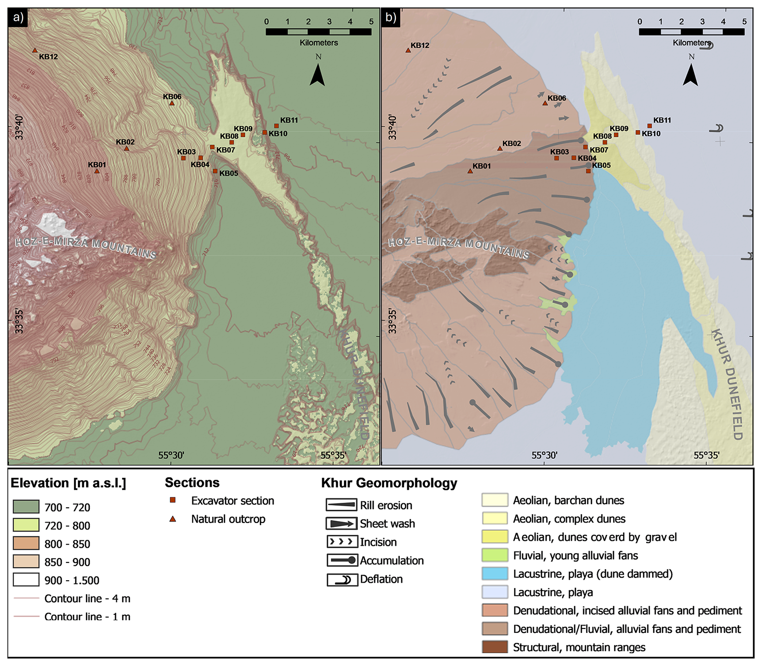
Figure 2Generalised geomorphological map of the study area.
4.1 Khur Basin geomorphology
The geomorphology of the Khur area is determined by a large-scale source-to-sink sediment cascade, with sediment transport predominantly from the Cretaceous sedimentary rock formations of the Hoz-e-Mirza Mountains, through the pediments of the Miocene marls and mudstones, which are partly covered by alluvial fans, to the erosional base formed by the playa of the endorheic basin 14 km away (Fig. 2). The regional slope of the pediments dips towards east-southeast with a mean angle of less than 1.5° in the distal areas. Sand dunes are located on top of the most distal parts of the pediments and on the playa's margins. Here, they block the alluvial fan deposits that are mantling the pediments. In the southern part of the area, an isolated playa surface formed.
Nine geomorphic units were mapped in the Khur area (Fig. 2). The units are described below according to their corresponding study sites and sections, except the “structural, mountain ranges” unit.
-
Medial alluvial fan (section KB01, see Fig. 2 for location): the medial zones of the fans are characterised by mature desert pavements and several dissected channels that are incised up to 2.5 m below the adjacent plain, which is mostly composed of angular gravels.
-
Incised alluvial fan and pediment (section KB02 and KB12): dissection of the alluvial fan surfaces involves active backward erosion and incision into the underlying pediment, with sharp erosional scarps and surfaces. This area is mostly covered by fluvial fine-grained and gravelly deposits encrusted by gypsum.
-
The cover sediments of the distal alluvial fan surface (sections KB03): downslope of the medial fan surface, the distal apron is formed by an active alluvial cover and characterised by a mixture of finer and coarser alluvium with shallow (1–2 m) saucer-shaped channels and rill erosion in between.
-
Undissected alluvial fan toe (section KB05): the distal part of the active alluvial fan surface ends in an undissected alluvial fan toe. It forms a transitional fringe between the playa and the alluvial fan, which is characterised by thin, recent fluvial gravels on the surface.
-
Eroded alluvial fan toe (section KB06): to the north, the alluvial fan toe is isolated by erosion of the surrounding sediments. It is covered by cobbly desert pavement and predominantly fine-grained well-sorted alluvium.
-
Sand dunes–alluvial fan contact zone (section KB04 and KB07): this zone of fluvial–aeolian interplay is situated at the western margin of the dune fields where the dunes confine the distal part of the alluvial fan.
-
Dune fields and sand dunes (section KB08, 9, 10): the Khur dune fields are located on the west-northwest margin of the main Sargardan and Shotoran sand seas in the southeast part of the Great Kavir (Maghsoudi, 2021). The Khur sand dunes are categorised into complex and barchan dunes (Fig. 2) and were classified as fully active dunes by Abbasi et al. (2019); northwestern winds are predominant. These geomorphic units are dominated by well-sorted aeolian sands with different stratigraphical structures. Wind ripples are also ubiquitous in the surface of the Khur dune fields, which have a wavelength between 150–200 mm and amplitude of 0.5–10 mm and align with the predominant NW wind direction in the Khur Basin.
-
Playa (section KB11): the playa surface is separated into two distinct elevation levels. The first level presents the extensive main playa at a level of 700 m a.s.l. (KB11, playa). The second is the dune-dammed playa surface, which is raised up to 4 m above the main playa surface. The geomorphic unit features a puffy surface and reveals structural variations where the central salic–gypsic crusts are interspersed with exposed mud and sand covers. A shallow groundwater level was observed by intrusion in a depth of approximately 2 m, further resulting in high soil moisture throughout the entire KB11 section due to capillary rise. Homogeneous fine-grained sediments are prominent features of this unit.
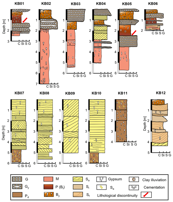
Figure 3Stratigraphic sketch of the Khur Basin sections (C: clay, Si: silt, S: sand, G: gravel, Gy: gravel with gypsum interlayers, Pd: playa deposits, M: reworked marls and mudstones, p: palaeosols, By: gypsic soil, Sa: aeolian sands, Sl: lacustrine sands, Sf: fluvial sands). Sites: KB01–KB06 – central alluvial fan; KB07-11 – dune field and playa; KB12 – northern alluvial fan.
4.2 Stratigraphy and sedimentary units
A total of 12 sedimentary sections are distributed throughout the basin (Fig. 3), with six sections located along the central alluvial fan (KB01, KB02, KB03, KB04, KB05, KB06), five sections located in the sand dunes and playa (KB07, KB08, KB09, KB10, and KB11), and KB12 representing the northernmost alluvial fan surface.
4.2.1 Central alluvial fan sections
Six sedimentary sections are distributed across the central alluvial fan (Fig. 3). They include the medial fan surface (KB01), the incised portion of the alluvial fan (KB02), alluvial cover of the distal alluvial fan surface (KB03, KB04), and the non-dissected alluvial fan toe (KB05) at the border of the alluvial fan and the playa. Where erosion has lowered the surrounding surfaces, dissected alluvial fan toe remnants (KB06) prevailed at slightly higher elevations (Fig. 2). These sections are generally composed of four common sedimentary units consisting of fluvial gravel (G), palaeosol (P), gypsic soil (By), and undifferentiated and partly reworked marls and mudstones (M) (Fig. 3). Unit M is mostly composed of densely packed homogeneous reddish-brown, silty clay and clay deposits, including evaporites. By is commonly characterised by a pale brownish massive loamy texture with low gravel content (<10 % gravel volume) and ∼ 30 %–50 % secondary gypsum accumulations in various forms such as pendant, filament, and blocky and irregular shapes. The palaeosol unit P typically features consolidated red-brownish clay loam with a distinct angular–subangular blocky structure, as well as secondary gypsum and carbonate accretions.
The sedimentary units the five central alluvial fan sections exhibit a similar pattern. The uppermost units consist of fluvial gravels (G) that exhibit downstream sorting and rounding towards the distal alluvial fan toe. The gravels in the middle of the KB01 sections show no systematic vertical fining or coarsening trend. The stratigraphy of KB01 section (Fig. 4d) is characterised by lateral discontinuities of the individual fluvial gravel strata and interbedding with finer-grained sediment lenses that are typical for braided river environments. Section KB02 is a 7 m high scarp in the incised area of the alluvial fan that allows a broad overview of the sedimentary successions (Fig. 4b and g).
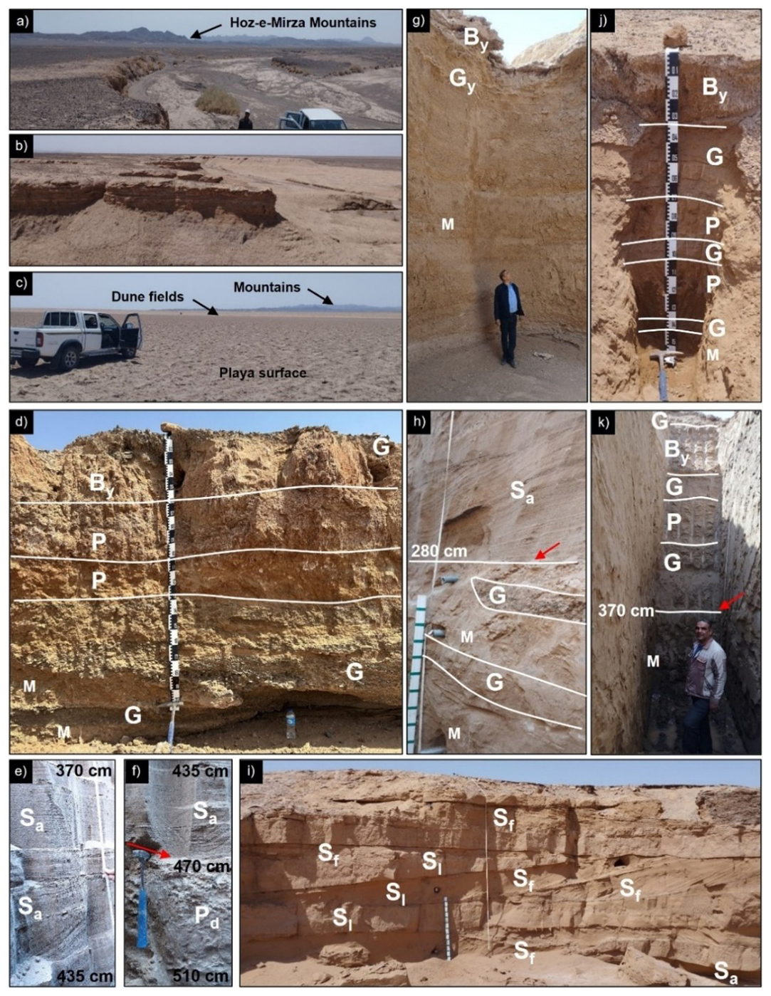
Figure 4Visual impressions of the Khur Basin landscape and record. (a) A westerly view of the mid-fan with a 2.5 m incised terrace. (b) A view of the dissected fan with erosional scarps and surfaces. (c) A westerly view of the Khur playa toward the sand dunes and mountains. (d) KB01 section stratigraphy; note the reddish palaeosol, with the interfingering of reworked marl deposits (M) and fluvial gravels (G) at its base. (e) Laminated aeolian sand dune (Sa) in section KB07. (f) The red arrow shows the contact zone between aeolian dune deposits (Sa) and playa sediments (Pd) in a depth of 470 cm in the KB07 section. (g) A broad view of the KB02 section stratigraphy in the wall of the backward erosion scarps in the alluvial fan, which has incised down into the clayey sediments of marl and mudstone. (h) The KB04 section stratigraphy; the red arrow shows the contact zone between aeolian deposits and marl deposits (M) as well as the interfingering of reworked marl deposits (M) and fluvial gravels (G) at a depth of 280–400 cm. (i) KB12 section stratigraphy is composed of fluvial sands (Sf), lacustrine sands (Sl), and aeolian sands (Sa). (j) KB06 section stratigraphy; note the palaeosol horizons separated by a thin layer of gravels and the interfingering of reworked marl deposits (M) and fluvial gravels (G) at its base. (k) KB05 section stratigraphy; note the contact zone between gravels (G) and reworked marl deposits (M) at a depth of 370 cm.
A layer of undifferentiated and partly reworked marls and mudstones (M) exists in the lowermost part of these sections (Fig. 3). Interfingering of the reworked marl and mudstone deposits (M) and fluvial gravels (G) was observed at the base of the KB01 and KB04 sections (Fig. 4g, h, and k), while KB06 showed the interfingering of the reworked marls (M), fluvial gravels (G), and fluvial sands (Sf) at its base layer (Fig. 3). At KB01 and KB05, there is a distinctive change from coarse fluvial gravels (G) to overlying palaeosols (see Figs. 3, 4d and k), which is also exposed at KB06 (Figs. 3 and 4j).
Generally, reddish palaeosols (P) and gypsic soil (By) units are placed in the middle of the section below the gravel units (G), while in the KB02 and KB06 sections, the gypsic soil appears at the surface. While gypsic soil horizons exhibit weak structures with few to no aggregates – and secondary gypsum accumulation predominating in many layers can be interpreted as results from pedogenesis – the palaeosol horizons show strong evidence of soil formation. These palaeosols (P) characterised by the clay-enriched reddish horizons (e.g. KB01 and KB06, KB05) have a strong angular structure with more blocky appearance than the overlying and underlying horizons. Most of these soil horizons have observable clay coatings and can be classified as argillic (Bt) horizons (Soil Survey Staff, 2022), argic horizons (IUSS Working Group WRB, 2022), or palaeoargillic horizons (Khormali et al., 2003). The two palaeosol units have a comparable degree of soil formation, while they show different degrees of gypsum precipitation. In contrast to the KB01 section, which includes two joined palaeoargillic horizons with a gradual boundary (Fig. 4d), KB06 palaeosol horizons are separated by a thin layer (10 cm) of fine fluvial gravels (G) (e.g. see Figs. 3 and 4j). Note that the KB06 section is located in the distal course of the incised channel, downstream of KB02. The area appears to constitute a separated alluvial fan toe remnant, which got isolated in the course of the fan toe dissection by backward erosion. This section has a stratigraphic pattern similar to the KB05 section, but it lacks the recent gravels at the surface. Instead, a gypsic soil (By) developed at the top of the section (Fig. 4k).
In contrast to the other four sections on the alluvial fans, section KB04 includes two units of aeolian sediment strata (Sa), consisting of coarse to medium sands with both cross-bedding and horizontal bedding in the middle of the section.
4.2.2 Dune and playa sections
Section KB07 was excavated near the toe of the alluvial fan. This ∼ 6 m deep section exhibits sets of aeolian sand strata (Sa) in the form of aeolian plane-bed lamination or cross-stratified beds down to 470 cm depth (Figs. 3, 4f). At the base of this section from 470–550 cm depth, moist sediments were detected, indicating the presence of groundwater. The contact zone between aeolian dune deposits and playa sediments was observed in a depth of 470 cm (Fig. 4f). The playa sediments (Pd) are interbedded by aeolian sands (Sa) and contain gypsum crystals.
Further to the northeast, three sections were excavated into the dune field deposits named KB08, KB09, and KB10. The dune surfaces are partly covered by a layer of coarse to very coarse sand. The two sections of KB08 and KB09 consist of 550 and 500 cm of laminated aeolian sand dune (Sa) deposits, respectively (Fig. 3). In KB10, the easternmost section of the sand dunes, a unit similar to the base of section KB07 was found at the lowest part of the section. This unit consists of playa deposits (Pd) mixed with aeolian sand, underlying the sand dune deposits. Section KB11 is a 4 m deep excavated section in the playa, located approximately 800 m east and 300 m south of the dune field, respectively. Near the surface, the playa deposits are moist; however, they may appear superficially dry, at least during the summer. The KB11 section consists of clastic sediments characterised by homogeneous and massive playa deposits (Pd) mixed with evaporites, primarily halite and gypsum. In the upper 1 m of the section, finely bedded aeolian sand is intercalated with massive clayey playa sediments, followed by playa deposits extending to a depth of 4 m. From a depth of 2 to 4 m, the playa deposits are heavily compacted and water-saturated.
4.2.3 Northern alluvial fan section
KB12 is 4 m high natural exposure (Fig. 4i) at an erosional scarp in the northern part of the incised alluvial fan. Gypsic gravels and soils are found above infilled palaeochannels. Thus, the stratigraphy of the KB12 section features four sedimentary units (Fig. 3). From top to bottom these sediments are (i) gypsic soil cover (By) partly buried by fluvial gravels (G), (ii) fluvial sands (Sf), (iii) lacustrine sands (Sl) partly fining-upward, and (iv) aeolian sands (Sa) at the base.
In this study, no numerical ages are available for the establishment of a geochronological framework. However, the results obtained allow the development of a relative chronological morphostratigraphy, which we interpret in the discussion with the help of the available literature and, thus, evaluate its regional significance. Firstly, the landforms and strata are analysed in Sect. 5.1 to deduce and characterise the geomorphic process domains in which they formed. Drawing analogies to comparable processes described in the literature helps to delineate periods in which such processes were predominant in the region. Secondly, the morphostratigraphic sequence and spatial extents of the landforms and strata provide the basis for a relative chronological model of heterogenic landscape evolution. The model and its palaeoclimatic implications are discussed in Sect. 5.2. Table 1 summarises numerical geochronological data from regional geoarchives used for the critical examination and spatiotemporal classification of the relative chronostratigraphy of this study.
5.1 Morphostratigraphic interpretation
This study aimed to decipher geomorphological features and responsible processes that have shaped the current heterogenic landscape of the hyper-arid Khur Basin in central Iran based on field observations. The main findings reveal that the Khur Basin underwent several cycles of stabilisation and reactivation that are evident within the pedo-sedimentary record and have been controlled by past climate changes. We focus on the geomorphological processes that occurred after the formation of the pediments which resulted from the Neogene–Quaternary orogenesis (Eghbal et al., 2018). These old pediments were mainly formed in reworked fine-grained sediments originally deposited during the Miocene (Eghbal et al., 2018) and are presently being eroded.
Based on the observed pedo-sedimentary and geomorphological inventory five main phases of dominant geomorphic process domains can be distinguished:
-
Alluvial fan aggradation and progradation
-
Playa and playa lake development
-
Surface stabilisation and soil formation
-
Inactivation phase and soil aridisation
-
Aeolian activities/processes
5.1.1 Alluvial fan aggradation and progradation
The alluvial mantling of the pediments is represented by the layers of fluvial gravels and sands at the base of distal and medial sections at KB01, KB04, KB05, and KB06. The pediment lithology was classified as the Miocene upper red formation (Navabi and Houshmandzadeh, 1969), and therefore the observed, undifferentiated and partly reworked marl, and mudstone sediments (M) are considered to originate from these Miocene pediments. They are intercalated with fluvial gravels (G) and sands (Sf) at the base of the KB01, KB04, and KB06 sections (Figs. 3, 4d, h, and j) and indicate expansive aggradation and progradation of the alluvial fans during and after the phase of pediment erosion. This is most probably related to the continuous uplift of the mountain systems (Eghbal et al., 2018).
Lateral discontinuities of the individual fluvial gravel strata and interbedding with finer-grained sediment lenses mostly observed in the medial fan surface (KB01 section, Figs. 3, 4d) represent the typical morphodynamics of braided alluvial fan channels and related avulsions. Such slope–fluvial geomorphic systems characterised by high sediment availability usually indicate conditions of infrequent high transport capacity resulting from intensive precipitation and discharge events in the catchment (May et al., 2008; Walk et al., 2019).
The last glacial history of alluvial fan development is well defined in Iran. Evidence of early alluvial fan abandonment during Marine Isotope Stage (MIS) 3 and earlier periods has been recorded in the alluvial fans of Marvast (Le Dortz et al., 2011), the central Zagros (Authemayou et al., 2009), Neyshabour (Hollingsworth et al., 2010), Minab (Regard et al., 2006), and Kashmar (Fattahi et al, 2007). However, evidence of younger alluvial fan development during the MIS 2 is suggested by the abandonment ages of the Neyshabour (24.1 ka; Hollingsworth et al., 2010), Minab (20.1 ka; Regard et al., 2006), and Mavast (26.9 ka; Le Dortz et al., 2009) fans located in northeastern, southern, and central Iran, respectively. In their review of luminescence studies of alluvial fan surface ages in Iran, Walker and Fattahi (2011) conclude that sediment supply predominantly controlled alluvial fan development in Iran. A cold and arid climate, with high sediment supply between 30 and 13 ka, is followed by a phase of increased rainfall and varying sediment availability between 13 and 9 ka, with wet conditions limiting the sediment supply between 9 and 7 ka. After 5 ka, increased aridity ceased alluvial fan development (Walker and Fattahi, 2011). Recent palaeoclimatic modelling conducted by Kirsten et al. (2023) covers the middle and late Holocene phases and supports this historic–genetic interpretation. However, the youngest alluvial fan progradations in central Iran could have continued until 5.8 ± 3.6 ka (Le Dortz et al., 2009). The semiarid large-scale sediment cascades of the Damghan Basin in northeastern Iran are characterised by a succession of alluvial fan surfaces that developed since the late Pleistocene (15 ka, maximum ages derived from OSL) with the onset of the youngest alluvial fan progradation in the late Holocene about 2.9–1.9 ka. The five individual age clusters of terminal alluvial fan surface activity can be correlated with four phases of dominant playa deposition, which suggest cyclic sedimentation and synsedimentary alteration within both alluvial fans and playa deposits (Büdel, 2020; Büdel et al., 2017). While local tectonic activities influenced fan morphology and incision patterns, Walker and Fattahi (2011) infer that climate exerted a more significant control on alluvial fan aggradation and progradation in eastern Iran based on regional chronological abandonment trends. The history of pre-Holocene alluvial fan development indicates that climate-controlled abandonment phases can also be inferred for the development of alluvial fans in the Khur Basin.
Table 1Geoarchives and climate records shown in Fig. 1 and all available age constraints used in this paper: dating methods include the following. OSL – optically stimulated luminescence; IRSL – infrared-stimulated luminescence; 10Be – cosmogenic 10Be exposure dating; 36Cl – 36Cl exposure age; 14C – radiocarbon; 210Pb – 210Pb-based method. Modified and extended after Walker and Fattahi (2011) and Kehl et al. (2023).
5.1.2 Lacustrine playa development
The central Khur Basin is characterised by homogeneous playa deposits (Pd) that contain fine-grained clastic sediments, such as clay and sand mixed with evaporites. The characteristics of the playa surface sediments are controlled by the sedimentary processes acting on the playa (Last, 1990). These sediments, as observed in KB10 and 11, are primarily transported into the main playa by runoff and, to a lesser extent, by wind. These processes are typical for playa environments, which are usually fed by ephemeral runoff, and the fine-grained clasts settle out of suspension during periods of standing water (Last, 1990; Rahimpour-Bonab and Abdi, 2012). Gypsum and other evaporites accumulated in the Khur playa and are deemed to be closely linked to their abundance in the Miocene sedimentary parent lithology (Ghorbani, 2019).
Jones et al. (2014) postulate that an early to middle Holocene highstand of Gavkhoni playa lake levels, 150 m above the recent level, was linked to the northward movement of the summer monsoon into the Iranian highlands. However, Shoaee et al. (2023) argue that such a high lake level required significantly more moisture, suggesting it may instead be related to wetter conditions during MIS 5, driven by northward migration of the Intertropical Convergence Zone (ITCZ) and possibly midlatitude westerly (MLW) amplifications (Kutzbach et al., 2014; Shoaee et al., 2023). Also, during MIS 2 considerable lake-level highstands were observed in Lake Van records (Çağatay et al., 2014). A study of alluvial sedimentary archives in Isfahan, central Iran, hypothesises that the interaction between the Mediterranean Sea, the Indian monsoon, and the northward shift of the ITCZ led to increased precipitation and high-magnitude runoff events. As a result, alluvial fans were able to advance far towards the playa, while at the same time fine sediment input caused the playa to grow, which led to alternating deposits of playa and alluvial fan layers. Solely based on a literature review, Jones et al. (2014) interpret the observed fluctuating lake levels as an indication of early Holocene climatic and hydrologic changes in central Iran. The parallel aggradation of both alluvial fan and corresponding playa surface was also observed by Büdel et al. (2017) and Büdel (2020) and dated to maximum ages of 55–11 ka (OSL), where the main alluvial fan deposits date to 15 and 13–3 ka. Although direct evidence of lake-level fluctuations, such as lake terraces, was not identified in the Khur Basin, various features of backward erosion of the distal to medial alluvial fan can be interpreted as a result of a lake regression and concomitant decrease in the erosional base. Subsequent playa development during the Holocene has been reported from the Jazmorian playa in southeastern Iran, where several dry periods with intensified aeolian inputs were recorded during the middle to late Holocene. These changes were attributed to the southward migration of the ITCZ and a shift in precipitation sources from monsoonal to MLW (Vaezi et al., 2019), which is in line with the Thar Desert playa archive (Singhvi and Kar, 2004).
5.1.3 Surface stabilisation phase soil formation
Periods of landscape stability and soil development are indicated by reddish-brownish palaeosols, which reflect phases of higher precipitation than today and are presumably correlated with surface stabilisation on the alluvial fans (May et al., 2008; Yakouti et al., 2024). Although precise chronological dating is required to confirm whether a soil qualifies as a palaeosol, in this study, the designation of reddish argillic soil horizons as palaeosols is intended to emphasise their development under environmental conditions markedly different from the present hyper-arid environment. Some of the respective palaeoargillic horizons (P) (Fig. 4d, KB01, Fig. 4k KB05) have sharp lower boundaries that can be interpreted as a lithological discontinuity between argillic horizons and allochthonous fluvial gravels (G). The palaeoargillic horizons can be considered in situ palaeosols due to the presence of visible intact coatings of illuvial clay on the peds and strong aggregation of the palaeosols observed in the field. However, precisely distinguishing between the in situ formed palaeosols and allochthonous soil sediments requires a careful assessment of vertical patterns of sedimentological proxies through possible palaeosol horizons (von Suchodoletz et al., 2018). In desert environments, argillic/argic horizons (Bt) indicate wetter past climate conditions (Hirmas and Graham, 2011; Mohammednoor et al., 2024; Retallack, 2019) and require thousands to tens of thousands of years to form (Birkeland, 1999; Walk et al., 2023).
Loess–palaeosol sequences of northern and northeastern Iran provide detailed records of a regional-scale climate change between dry (dust accumulation) and moist (soil formation) conditions. It is suggested that clay-rich palaeosols formed during Marine Isotope Stage (MIS) 5 and loess was deposited during MIS 4, and the formation of several weakly developed synsedimentary palaeosols followed during the MIS 3 (Karimi et al., 2011; Kehl et al., 2021). Applying luminescence dating and micromorphology to the relict and buried palaeosols in two alluvial fans showed the estimated age of 35 ± 7 ka for buried palaeosol of Bajestan (northeast) and 107 ± 11, 73 ± 6, and 40 ± 8 ka for the palaeosols of Isfahan (central) (Rashidi et al., 2021). Four main periods of pedogenesis are recorded for MIS 5, MIS 3, and at the MIS 3/2 transition as well as the MIS 2/1 transition in central and northeast Iran (Rashidi et al., 2019, 2021).
Recently, Bayat et al. (2023) used chronostratigraphic and stable isotope analysis of pedogenic carbonates in palaeosols to identify three main palaeoclimatic stages in central Iran over the past 32 kyr. The first stage (31.6–26.0 ka) featured sub-humid conditions, deep leaching, and expansion of C4 plants, followed by semiarid conditions with increasing aridity until the late Holocene. In the final stage, during the late Holocene, the region became arid, featuring sparse vegetation and an evaporative environment. Based on morphological comparisons to palaeosols studied by Bayat et al. (2023) and Rashidi et al. (2021) in central and northeastern Iran, it can be inferred that the soil formation period in the Khur Basin corresponds to that of these regions, and palaeosols likely developed during periods of increased precipitation in the MIS 3 or earlier. Furthermore, initial soil development in the Khur region might be related to the higher moisture availability at the end of the last glacial period, as indicated by stalagmites and lake sediments in Iran (Aubert et al., 2019; Djamali et al., 2008; Soleimani et al., 2023).
5.1.4 Inactivation phase and soil aridisation
Inactivation of alluvial fan surface occurs when deposition of alluvial sediments on the alluvial fans ceases over a broad area of the basin or when proximal fan surfaces are disconnected by ongoing progradation. Regional abandonment of alluvial fan surfaces or cessation of alluvial fan progradation can occur due to changes in environmental conditions such as climate shifts or tectonic activity (Walker and Fattahi, 2011; Lehmkuhl and Owen, 2024). Over time, these abandoned and inactive alluvial fan surfaces undergo gypsiferous soil (By) formation, while (fluvial) sediment erosion and deposition are minimised. Marine sulfates of Cretaceous age are the main source of the soil gypsum in Iran. Evaporation of soil water saturated with SO is considered to be the major mechanism for gypsum accumulation in the soils of these regions (Farpoor and Krouse, 2008; Khademi et al., 1997a). As Khademi et al. (1997b) suggest for the Isfahan region, here in the Khur Basin transportation of sulfates from the Cretaceous catchment lithology, across the Miocene pediment bedrock and the alluvial fans to the playa, occurred in a dry yet slightly more humid climate than today. In contrast, during phases of increased aridity the gypsiferous aeolian dust input from the eroded Miocene formations is deemed to be the dominant source. Transportation of evaporites by aeolian processes has been considered an important mechanism for the source of gypsum and carbonate in arid–semiarid soils of Iran and other deserts of the world (Bayat et al., 2023; Karimi et al., 2009; Rech et al., 2003). Gypsum pendants beneath gravels indicate the vertical movement of saturated soil solutions translocating the allochthonous gypsum. Furthermore, gypsum transported by both surface runoff along the alluvial fans and subsurface flow following seepage needs to be considered a pathway to the distal components of the sediment cascade (cf. Farpoor et al., 2012).
Consequently, the ubiquitous highly gypsic soil horizons in the study area may have developed due to increased aridity (Kong et al., 2022) in the final phase of Khur Basin evolution. The local inactivation phases and surface abandonments were accompanied by increasing aridity and conditions suitable for evaporite precipitation. Bayat et al. (2023) report on the Quaternary fluvial setting of Isfahan (central Iran), where gypsum crystals are found to be younger than carbonates, which have an age of about 10–16 ka. These observations suggest that at least part of the Holocene was drier than the period of carbonate precipitation between 10 and 16 ka. Although these sites are located 350 km to the SW of the area studied here, it shares relatively comparable elevations, geological settings, and soil characteristics such as colour, structure, and pedogenic features (cf. Bayat et al., 2023). This suggest that the temporal constraints established by Bayat et al. (2023) may be transferable to the Khur area.
5.1.5 Aeolian activity
The active aeolian sand dunes in the east-southeast of the Khur Basin are the extension of the active Rig-e Shotoran, which is characterised by its variety of complex and barchan dune types. Aeolian deposits at the contact zone of the alluvial fans and playa have, at some point in the past, blocked the drainage from the playa depression, resulting in the elevated playa sediments. The 500–600 cm well-sorted aeolian sand deposits (Sa in KB07 to KB10) in this geomorphic position indicate a prolonged period of aeolian dominance. The internal stratigraphy of the dune sections includes the presence of the old playa surface at the lowest part of the dunes, implying aeolian accumulation directly deposited upon the playa sediments at the playa margin. This contact zone recorded the transition of the lacustrine to aeolian depositional environment during periods of reduced runoff and increased wind speed. Another transitional zone was detected at the western margin of the dune field, where it interacts with the alluvial fan sediments (KB04). Here, dunes initially advanced onto the pediment but were later covered by alluvial sediments.
Complex dunes consist of two or more different types of dunes that are superimposed or coalesced. This morphology resulted from different wind regimes with different directions and strengths, which causes different dune types and orientations (Bristow and Mountney, 2013; Lancaster, 2013). Mahmoudi (2002) indicates that most of the Iranian dune fields have two generations of old (palaeo) and new (young) sand dunes, which may imply at least two main periods of dune development with different wind directions in Iran.
However, absolute dates for the aeolian deposits of Iran are rare and limited to only two studies on the sand ramps and coastal dunes in central and northern Iran. The chronological constraints on the 25 m aeolian sand-ramp deposits indicated an accumulation period of 28–18 ka, coinciding with cold and arid conditions in Iran during the Last Glacial Maximum (LGM) (Mehrshahi et al., 1999; Thomas et al., 1997). This is in line with the ages of the dunes at the Persepolis Basin's margins that have their origin in the LGM (Kehl et al., 2005). The formation of dunes and sand ramps in southwest and central Iran was likely driven by intense frost weathering during the LGM (Kehl et al., 2005). According to the time of dune formation indicated by Thomas et al. (1997) and Kehl et al. (2005), the Khur dune layers are considered to be of late glacial period, most likely MIS 2. A dry and dusty period between 13.2 and 11.4 ka was recorded in the Jazmurian playa sediments, southeastern Iran, possibly related to the southward migration of the ITCZ in southeastern Iran (Vaezi et al., 2019). Similar, dry conditions during the Younger Dryas are indicated by increased salinity and a drop in lake levels as well as higher dust inputs in Lake Neor (Sharifi et al., 2015), Zeribar (Kazancı et al., 2016; Snyder et al., 2001; Stevens et al., 2001; Wasylikowa, 2005; Wasylikowa et al., 2006), and Konar Sandal peatbogs (Safaierad et al., 2020).
Kehl et al. (2023) recently reviewed several sedimentary archives of Holocene climate and environmental dynamics in Iran, which indicate arid conditions during the Holocene, dry phases concomitant with the 8.2, 5.9/5.2, and 4.2 ka Holocene rapid climate change events (Kirsten et al., 2023), and several additional dry phases in the Iranian highlands. Dry and windy climatic conditions and sparse vegetative cover during the Holocene should favour strong aeolian activity and the development of the sand dunes in central Iran.
Pollen spectra from lake Mirabad and Zeribar reflect the low rainfall until around 6 ka, when oak forests started to expand in the surrounding of these lakes (Zeist and Bottema, 1991). Similarly, pollen data from Lake Neor show that the climate remained relatively dry until 8.7 ka in northwestern Iran (Aubert et al., 2017). Furthermore, the high-resolution reconstruction of aeolian input from Neor Lake in northwest Iran indicates that several episodes of increased dust input during the middle to late Holocene align with the time of environmental risks for ancient societies across the Iranian Plateau, Mesopotamia, and the eastern Mediterranean region (Sharifi et al, 2015). Evidence of further extended droughts during 1.7–0.5 ka is inferred from the multi-proxy records from several regions, including Lake Mirabad and Zeribar in the west (Stevens et al., 2006, 2001), the Gulf of Oman in the south (Miller et al., 2016), and the Pounel Mire in the north of the Iranian highlands (Homami Tomaj et al., 2021).
In the Khur Basin, the playa depression structures, along with the active dunes bordering the playa, are largely influenced by current hyper-arid conditions and strong wind erosion. We argue that wind activity is primarily responsible for forming the depression (deflation) features (cf. Jolivet et al., 2021) and active dune migration as currently dominant geomorphic processes. Additionally, the presence of dense, fragmented, and platy gypsum crystals within the active dunes and surface soils enriched with secondary gypsum (Fig. 4g and j) indicates prevailing aridity conditions in the study area. Mobile wind ripples frequently observed on the surface of the dune field and its margins suggest current arid and sandy environments, characterised by the dominance of aeolian saltation (Maghsoudi, 2021) in the Khur Basin.
5.2 Landscape evolution stages and palaeoclimatic implications
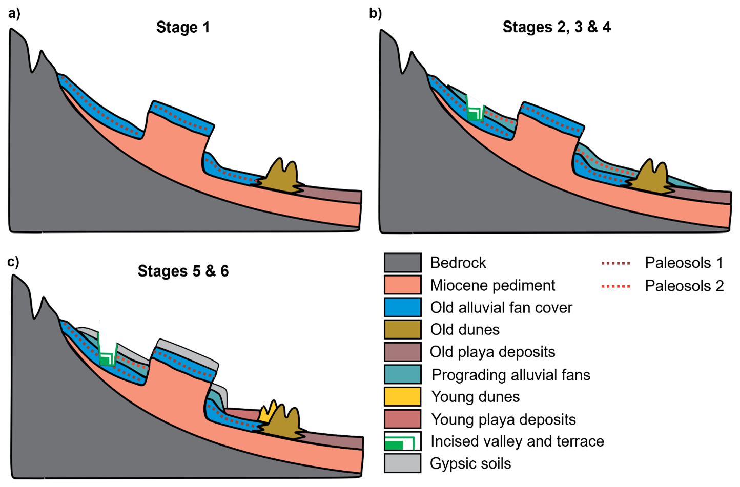
Palaeoclimatic and landscape reconstruction by using dryland sedimentary archives is challenging due to episodic sedimentation, discontinuous archives, and interacting (overlapping) geomorphic processes largely driven by climatic changes (Jones et al., 2014; Stauch, 2016) but still has high potential to study landscape–climate interactions. Figure 5 summarises the main stages of landscape evolution of the Khur Basin with relative timescales since the late Pleistocene. The model implies a highly dynamic geomorphological evolution of the Khur Basin. Different depositional environments, wetter and drier conditions, and landscape stability are directly deduced based on our geomorphological and stratigraphical results. The proposed stages of landscape evolution are complemented by geochronological estimates based on the review of numerically dated regional archives (cf. Table 1).
-
Stage 1: Prior to and during MIS 3 – erosion of pediment and palaeodune development, soil formation in the old alluvial covers
The first stage is characterised by the dissection and linear erosion of the pediment surface formed by denudation in the Miocene sediments, as well as by the formation of local alluvial sediment covers. The period of fan deposition in central Iran may have occurred during the last glacial, most likely in MIS 3 and earlier. The formation of the palaeosol 1 in the Khur Basin is attributed to landscape stability and increased rainfall, probably during MIS 3.
-
Stage 2: ∼ LGM and MIS 2, cold arid conditions – frost weathering, high sediment supply, alluvial fan progradation, dune formation
During this period, debris production increased due to frost weathering and slightly higher precipitation, resulting in widely observed progradation of alluvial fans along the mountain ranges. Intense frost weathering along with dry conditions during the LGM or earlier likely caused the development of the sand dunes in central Iran.
-
Stages 3: Transition from last glacial period to the Holocene – increased rainfall, high lake level, decreased sediment supply, lateral erosion, and terrace formation in incised channels, development of younger soils within older fan surfaces
A sharp increase in precipitation during this phase may lead to the formation of a perennial lake in the playa or, if it already existed, to significantly higher lake levels and initial soil development. This phase of soil formation might be related to wetter climate conditions than today in Iran that occurred at the end of the last glacial. No fossil lake terraces were observed in the field and phases of lake-level fluctuations are only indicated by the ubiquitous presence of backward erosional features. Their distribution and form may be explained by a pronounced decrease in the erosional base in the course of a suggested lake-level retreat (Stage 4) that followed the highstand of a former lake.
-
Stage 4: Younger Dryas event – severe drought and lake-level retreat, alluvial fan dissection, dune formation
The intense drought during the Younger Dryas was accompanied by both a dramatic decline in lake levels in the greater region and the disappearance of the vegetation that stabilised the surfaces. Intensified autochthonous fragmentation of the previously stable surfaces was the result, and inactive dunes and soils were translocated.
-
Stage 5: ∼ Early to mid-Holocene, arid conditions – reactivation of dunes and blocking of the alluvial plain, onset of elevated playa formation
At this stage, the previous, strong decline in the vegetation and water areas, contemporaneous with presumably intensified wind strength and, as the mapping of the dune directions suggests, changed wind directions, resulted in the partial reactivation and new formation of the dune fields located at the edge of the basin. The dune field migrating in a southeasterly direction in the study area has thus separated a part of the main playa of the Great Kavir with new, up to 4 m thick playa sediments deposited subsequently. The relatively dry climate during the mid-Holocene is further supported by pollen records from several lake archives of Iran.
-
Stage 6: Late Holocene to present – overall trend of increasing aridity, deflation of playa surface, and development of gypsic soils on abandoned alluvial fan surface, aggradation and reworking on blocked alluvial fan surface
The final stage led to the current appearance of the landscape in the study area. The increasing aridity in the course of the Holocene caused aeolian processes to dominate and in turn intensive deflation resulted in a further deepening of the main playa. Initial gypsiferous soils have formed on the abandoned and partially eroded alluvial fan surfaces. The landscape evolution model systematically integrates observations from sediments sequences, soil characteristics, and arrangements of landforms within the sediment cascade. The complex spatiotemporal interplay of the processes that primarily characterise landscape evolution thus becomes apparent and initially isolated observations can be transferred into a larger-scale but continuous development model.
The landscape of the hyper-arid Khur Basin in the central part of the Iranian Plateau reveals a diverse geoarchive setting with spatially and temporally discontinuous but geomorphologically connected and well-preserved records, whose combined information spans the Miocene to late Holocene periods. Despite notable advancements, a gap remains in interpreting the spatiotemporal relationships between main geomorphic process domains, which have often been studied in isolation. This study fills this gap by integrating stratigraphical and pedological evidence from 12 sedimentary sequences and geomorphological features along the basin to reconstruct the regional landscape evolution and its climatic implications. Distinctive stages of landscape evolution with various shifting between depositional environments and varying climatic conditions are outlined in this study. Our findings highlight the dynamic interplay between erosion, sediment deposition, soil formation, and hydrological processes throughout the different stages of landscape evolution, from the erosion of the Miocene pediment surface (Stage 1) to the formation of gypsic soils on abandoned fan surfaces and the deflation of present-day playa surface (Stage 6). By systematically linking observations from various stages, we provide a comprehensive framework of the heterogenic late Quaternary landscape evolution in a relative chronological order. This integrated approach not only clarifies the complex spatiotemporal interactions between geomorphic process domains but also opens a new perspective for future studies on geomorphic responses to environmental changes, specifically in extreme environments like central Iran. Further work involving high-resolution numerical dating is required to refine and quantify the geochronological framework of the proposed landscape evolution model and to further elucidate the basin landscape response to late Quaternary climate changes.
The land surface parameters of this study were produced using Copernicus WorldDEM-30 © DLR e.V. 2010–2014 and © Airbus Defence and Space GmbH 2014–2018 provided under COPERNICUS by the European Union and ESA; all rights reserved. These data are freely available and can be accessed via the Copernicus Data Space portal (https://doi.org/10.5270/ESA-c5d3d65, Copernicus, 2019). The georeferenced geological maps of Iran covering the study area can be purchased from the Geological Survey of Iran. All other data will be made available upon request to the authors.
Conceptualisation of the project was done by CB, MF, and RB. ZRK and MT carried out the fieldwork in Iran. Fieldwork was supported by AK. ZRK and CB did most of the investigation and data validation. ZRK, CB, JW, and GS did the writing of the original draft. The final paper was reviewed and edited by all authors.
At least one of the (co-)authors is a member of the editorial board of E&G Quaternary Science Journal. The peer-review process was guided by an independent editor, and the authors also have no other competing interests to declare.
Publisher's note: Copernicus Publications remains neutral with regard to jurisdictional claims made in the text, published maps, institutional affiliations, or any other geographical representation in this paper. While Copernicus Publications makes every effort to include appropriate place names, the final responsibility lies with the authors. Views expressed in the text are those of the authors and do not necessarily reflect the views of the publisher.
We would like to acknowledge the support from Khur Potash Company during our fieldwork. We are deeply grateful to Mashall Mohammad Saffar, who provided us with unconditional support throughout the fieldwork. Sadly, he passed away in early 2024, and we would like to dedicate this paper to his memory. We also express our gratitude to Philipp Garbe from the Institute of Geography and Geology in Würzburg for his great support with the figures. We would like to thank the German Research Foundation (DFG) for its financial support of our project.
This research has been supported by the Deutsche Forschungsgemeinschaft (grant no. 452625374).
This paper was edited by Tony Reimann and reviewed by three anonymous referees.
Abbasi, H. R., Opp, C., Groll, M., Rohipour, H., and Gohardoust, A.: Assessment of the distribution and activity of dunes in Iran based on mobility indices and ground data, Aeolian Research, 41, 100539, https://doi.org/10.1016/j.aeolia.2019.07.005, 2019.
Abbassi, N., Khoshyar, M., Lucas, S. G., and Esmaeili, F.: Extensive vertebrate tracksite from the Upper Red Formation (middle–late Miocene), west Zanjan, northwestern Iran, Foss. Rec., 24, 101–116, https://doi.org/10.5194/fr-24-101-2021, 2021.
Arzani, N. and Jones, S. J.: Upstream controls on evolution of dryland alluvial megafans: Quaternary examples from the Kohrud Mountain Range, central Iran, Geological Society, London, Special Publications, 440, 245–264, https://doi.org/10.1144/SP440.2, 2018.
Armitage, S. J., Jasim, S. A., Marks, A. E., Parker, A. G., Usik, V. I., and Uerpmann, H. P.: The southern route “out of Africa”: evidence for an early expansion of modern humans into Arabia, Science, 331, 453–456, https://doi.org/10.1126/science.1199113, 2011.
Aubert, C., Brisset, E., Djamali, M., Sharifi, A., Ponel, P., Gambin, B., Akbari Azirani, T., Guibal, F., Lahijani, H., Naderi Beni, A., and De Beaulieu, J. L.: Late glacial and early Holocene hydroclimate variability in northwest Iran (Talesh Mountains) inferred from chironomid and pollen analysis, Journal of Palaeolimnology, 58, 151–167, https://doi.org/10.1007/s10933-017-9969-8, 2017.
Aubert, C., Djamali, M., Jones, M., Lahijani, H., Marriner, N., Naderi-Beni, A., Sharifi, A., Ponel, P., and Gandouin, E.: A major hydrobiological change in Dasht-e Arjan Wetland (southwestern Iran) during the late glacial–early Holocene transition revealed by subfossil chironomids, Canadian journal of earth sciences, 56, 848–856, https://doi.org/10.1139/cjes-2018-0256, 2019.
Authemayou, C., Bellier, O., Chardon, D., Benedetti, L., Malekzade, Z., Claude, C., Angeletti, B., Shabanian, E., and Abbassi, M. R.: Quaternary slip-rates of the Kazerun and the Main Recent Faults: active strike-slip partitioning in the Zagros fold-and-thrust belt, Geophysical Journal International, 178, 524–540, https://doi.org/10.1111/j.1365-246X.2009.04191.x, 2009.
Bartz, M., Walk, J., Binnie, S. A., Brill, D., Stauch, G., Lehmkuhl, F., Hoffmeister, D., and Brueckner, H.: Late Pleistocene alluvial fan evolution along the coastal Atacama Desert (N Chile), Global and Planetary Change, 190, 103091, https://doi.org/10.1016/j.gloplacha.2019.103091, 2020.
Bayat, O., Karimzadeh, H., Eghbal, M. K., Karimi, A., and Amundson, R.: Calcic soils as indicators of profound Quaternary climate change in eastern Isfahan, Iran, Geoderma, 315, 220–230, https://doi.org/10.1016/j.geoderma.2017.11.007, 2018.
Bayat, O., Karimi, A., May, J.-H., Fattahi, M., Wiesenberg, G. L., and Egli, M.: High-resolution record of stable isotopes in soil carbonates reveals environmental dynamics in an arid region (central Iran) during the last 32 ka, Frontiers in Earth Science, 11, 1154544, https://doi.org/10.3389/feart.2023.1154544, 2023.
Berberian, M. and King, G.: Towards a palaeogeography and tectonic evolution of Iran, Canadian Journal of Earth Sciences, 18, 210–265, https://doi.org/10.1139/e81-019, 1981.
Birkeland, P.: Soils and Geomorphology, 3nd Ed, Oxford University Press, New York, 430 pp., ISBN 9780195078862, 1999.
Bristow, C. and Mountney, N. P.: Aeolian stratigraphy, in: Treatise on Geomorphology, edited by: Shroder, J., Lancaster, N., Sherman, D. J., and Baas, A. C. W., Academic Press, San Diego, CA, Aeolian Geomorphology 11, 246–268, https://doi.org/10.1016/B978-0-12-374739-6.00306-7, 2013.
Büdel, C.: Quaternary alluvial fan morphodynamics and basin sedimentation in North Iran, Würzburger Geographische Arbeiten, 123, 126, https://doi.org/10.25972/WUP-978-3-95826-115-0, 2020.
Büdel, C., Padashi, S. M., Hoelzmann, P., Fuchs, M., and Baumhauer, R.: The correlation of North-Iranian Late-Pleistocene and Holocene playa sediments to basin geomorphology, Zeitschrift fur Geomorphologie Supplement, 61, 77–99, https://doi.org/10.1127/zfg_suppl/2016/0419, 2017.
Breeze, P. S., Drake, N. A., Groucutt, H. S., Parton, A., Jennings, R. P., White, T. S., Clark-Balzan, L., Shipton, C., Scerri, E. M., Stimpson, C. M., and Crassard, R.: Remote sensing and GIS techniques for reconstructing Arabian palaeohydrology and identifying archaeological sites, Quaternary International, 382, 98–119, https://doi.org/10.1016/j.quaint.2015.01.022, 2015.
Busch, R., Bernbeck, R., Hessari, M., Kirsten, F., Lüthgens, C., Pollock, S., Rol, N., and Schütt, B.: Linking archaeology and palaeoenvironment: Mid-Holocene occupational sequences in the Varamin Plain (Iran), Geoarchaeology, https://doi.org/10.1002/gea.21995, 2024.
Çağatay, M. N., Öğretmen, N., Damcı, E., Stockhecke, M., Sancar, Ü., Eriş, K. K., and Özeren, S.: Lake level and climate records of the last 90 ka from the Northern Basin of Lake Van, eastern Turkey, Quaternary Science Reviews, 10497–104116, https://doi.org/10.1016/j.quascirev.2014.09.027, 2014.
Copernicus: WorldDEM-30 (GLO-30): [data set], DLR e.V. 2010-2014; Airbus Defence and Space GmbH 2014–2018, Copernicus [data set], https://doi.org/10.5270/ESA-c5d3d65, 2019.
Delagnes, A., Tribolo, C., Bertran, P., Brenet, M., Crassard, R., Jaubert, J., Khalidi, L., Mercier, N., Nomade, S., Peigné, S., and Sitzia, L.: Inland human settlement in southern Arabia 55,000 years ago. New evidence from the Wadi Surdud Middle Palaeolithic site complex, western Yemen, Journal of Human Evolution, 63, 452–474, https://doi.org/10.1016/j.jhevol.2012.03.008, 2012.
Djamali, M., Kürschner, H., Akhani, H., de Beaulieu, J.-L., Amini, A., Andrieu-Ponel, V., Ponel, P., and Stevens, L.: Palaeoecological significance of the spores of the liverwort Riella (Riellaceae) in a late Pleistocene long pollen record from the hypersaline Lake Urmia, NW Iran, Review of Palaeobotany and Palynology, 152, 66–73, https://doi.org/10.1016/j.revpalbo.2008.04.004, 2008.
Dunseth, Z. C., Junge, A., Lomax, J., Boaretto, E., Finkelstein, I., Fuchs, M., and Shahack-Gross, R.: Dating archaeological sites in an arid environment: A multi-method case study in the Negev Highlands, Israel, Journal of Arid Environments, 144, 156–169, https://doi.org/10.1016/j.plabm.2017.04.007, 2017.
Eghbal, M. K., Hamzehpour, N., and Farpoor, M. H.: Geology and Geomorphology, in: Mohammad Hassan Roozitalab, Hamid Sidat und Abbas Farshad, The Soils of Iran, Springer International Publishing, 35–56, https://doi.org/10.1007/978-3-319-69048-3_4, 2018.
Farpoor, M. and Krouse, H.: Stable isotope geochemistry of sulfur bearing minerals and clay mineralogy of some soils and sediments in Loot Desert, central Iran, Geoderma, 146, 283–290, https://doi.org/10.1016/j.geoderma.2008.06.002, 2008.
Farpoor, M., Khademi, H., Eghbal, M., and Krouse, H.: Mode of gypsum deposition in southeastern Iranian soils as revealed by isotopic composition of crystallization water, Geoderma, 121, 233–242, https://doi.org/10.1016/j.geoderma.2003.11.013, 2004.
Farpoor, M., Neyestani, M., Eghbal, M., and Borujeni, I. E.: Soil–geomorphology relationships in Sirjan playa, south central Iran, Geomorphology, 138, 223–230, https://doi.org/10.1016/j.geomorph.2011.09.005, 2012.
Fattahi, M., Walker, R. T., Khatib, M. M., Dolati, A., and Bahroudi, A.: Slip-rate estimate and past earthquakes on the Doruneh fault, eastern Iran, Geophysical Journal International, 168, 691–709, https://doi.org/10.1111/j.1365-246X.2006.03248.x, 2007.
Ghorbani, M.: Lithostratigraphy of Iran, Cham, Springer, ISBN 978-3-030-04963-8, 2019.
Groucutt, H. S., White, T. S., Scerri, E. M., Andrieux, E., Clark-Wilson, R., Breeze, P. S., Armitage, S. J., Stewart, M., Drake, N., Louys, J., and Price, G. J.: Multiple hominin dispersals into Southwest Asia over the past 400,000 years. Nature, 597, 376–380, https://doi.org/10.1038/s41586-021-03863-y, 2021.
Hamzeh, M. A., Gharaie, M. H. M., Lahijani, H. A. K., Djamali, M., Harami, R. M., and Beni, A. N.: Holocene hydrological changes in SE Iran, a key region between Indian Summer Monsoon and Mediterranean winter precipitation zones, as revealed from a lacustrine sequence from Lake Hamoun, Quaternary International, 408, 25–39, https://doi.org/10.1016/j.quaint.2015.11.011, 2016.
Hirmas, D. R. and Graham, R. C.: Pedogenesis and soil-geomorphic relationships in an arid mountain range, Mojave Desert, California, Soil Science Society of America Journal, 75, 192–206, https://doi.org/10.2136/sssaj2010.0152, 2011.
Hollingsworth, J., Fattahi, M., Walker, R., Talebian, M., Bahroudi, A., Bolourchi, M. J., Jackson, J., and Copley, A.: Oroclinal bending, distributed thrust and strike-slip faulting, and the accommodation of Arabia-Eurasia convergence in NE Iran since the Oligocene, Geophysical Journal International, 181, 1214–1246, https://doi.org/10.1111/j.1365-246X.2010.04591.x, 2010.
Homami Totmaj, L., Ramezani, E., Alizadeh, K., and Behling, H.: Four millennia of vegetation and environmental history above the Hyrcanian forest, northern Iran, Veget Hist Archaeobot, 30, 611–621, https://doi.org/10.1007/s00334-020-00813-y, 2021.
IUSS Working Group WRB: World Reference Base for Soil Resources. International soil classification system for naming soils and creating legends for soil maps, 4th edition, International Union of Soil Sciences (IUSS), Vienna, Austria, 2022.
Jackson, M., Cornelius, R., Craig, C., Gansser, A., Stöcklin, J., and Talbot, C.: Salt diapirs of the Great Kavir, central Iran, Geological Society of America: Memoirs, https://doi.org/10.1130/MEM177-p1, 1990.
Jolivet, M., Braucher, R., Dovchintseren, D., Hocquet, S., Schmitt, J. M., and Aster Team: Erosion around a large-scale topographic high in a semi-arid sedimentary basin: Interactions between fluvial erosion, aeolian erosion and aeolian transport, Geomorphology, 386, 107747, https://doi.org/10.1016/j.geomorph.2021.107747, 2021.
Jones, S. J., Arzani, N., and Allen, M. B.: Tectonic and climatic controls on fan systems: the Kohrud mountain belt, Central Iran, Sedimentary Geology, 302, 29–43, https://doi.org/10.1016/j.sedgeo.2013.12.008, 2014.
Karimi, A., Khademi, H., Kehl, M., and Jalalian, A.: Distribution, lithology and provenance of peridesert loess deposits in northeastern Iran, Geoderma, 148, 241–250, https://doi.org/10.1016/j.geoderma.2008.10.008, 2009.
Karimi, A., Frechen, M., Khademi, H., Kehl, M., and Jalalian, A.: Chronostratigraphy of loess deposits in northeast Iran, Quaternary International, 234, 124–132, https://doi.org/10.1016/j.quaint.2009.08.002, 2011.
Kazancı, N., Gulbabazadeh, T., Leroy, S. A., Ataselim, Z., and Gürbüz, A.: Aeolian control on the deposition of high altitude lacustrine basins in the Middle East: The case of Lake Neor, NW Iran, Quaternary International, 408, 65–77, https://doi.org/10.1016/j.quaint.2015.11.040, 2016.
Kehl, M.: Quaternary climate change in Iran–the state of knowledge, Erdkunde 63, 1–17, https://www.jstor.org/stable/25648171, 2009.
Kehl, M., Sarvati, R., Ahmadi, H., Frechen, M., and Skowronek, A.: Loess paleosoil-sequences along a climatic gradient in Northern Iran, E&G Quaternary Sci. J., 55, 149–173, https://doi.org/10.3285/eg.55.1.08, 2005.
Kehl, M., Vlaminck, S., Köhler, T., Laag, C., Rolf, C., Tsukamoto, S., Frechen, M., Sumita, M., Schmincke, H.-U., and Khormali, F.: Pleistocene dynamics of dust accumulation and soil formation in the southern Caspian Lowlands-New insights from the loess-palaeosol sequence at Neka-Abelou, northern Iran, Quaternary Science Reviews, 253, 106774, https://doi.org/10.1016/j.quascirev.2020.106774, 2021.
Kehl, M., Rafiei-Alavi, B., and Lahijani, H. A.: Holocene Palaeoenvironmental Change and Phases of Drought in the Iranian Highlands. A review, in: Coming to Terms with the Future: Concepts of Resilience for the Study of Early Iranian Societies, edited by: Bernbeck, R., Pollock, S., and Eberhardt, G., Sidestone Press, Leiden, 21–38, ISBN 978-94-6426-147-9, 2023.
Khademi, H., Mermut, A., and Krouse, H.: Isotopic composition of gypsum hydration water in selected landforms from central Iran, Chemical Geology, 138, 245–255, https://doi.org/10.1016/S0009-2541(97)00017-X, 1997a.
Khademi, H., Mermut, A., and Krouse, H.: Sulfur isotope geochemistry of gypsiferous Aridisols from central Iran, Geoderma, 80, 195–209, https://doi.org/10.1016/S0016-7061(97)00091-8, 1997b.
Khormali, F., Abtahi, A., Mahmoodi, S., and Stoops, G.: Argillic horizon development in calcareous soils of arid and semiarid regions of southern Iran, Catena, 53, 273–301, https://doi.org/10.1016/S0341-8162(03)00040-7, 2003.
Khosravichenar, A., Fattahi, M., Amini, H., and Suchodoletz, H. V.: The potential of small mountain river systems for palaeoenvironmental reconstructions in drylands–an example from the Binaloud Mountains in northeastern Iran, Geosciences, 10, 448, https://doi.org/10.3390/geosciences10110448, 2020.
Kirsten, F., Dallmeyer, A., Bernbeck, R., Böhmer, T., Busch, R., Hessari, M., Pollock, S., and Schütt, B.: Were climatic forcings the main driver for mid-holocene changes in settlement dynamics on the Varamin Plain (Central Iranian Plateau)?, PloS one, 18, e0290181, https://doi.org/10.1371/journal.pone.0290181, 2023.
Kong, T., Tudryn, A., Gibert-Brunet, E., Tucholka, P., Motavalli-Anbaran, S.-H., Ahmady-Birgani, H., Lankarani, M., Miska, S., Noret, A., and Dufaure, O.: 30 000 Years of the southwestern Lake Urmia (Iran) palaeoenvironmental evolution inferred from mineralogical indicators from lake and watershed sediments, Journal of Asian Earth Sciences, 239, 105387, https://doi.org/10.1016/j.jseaes.2022.105387, 2022.
Krinsely, D. B.: A geomorphological and palaeoclimatological study of the playas of Iran: Final report 1965–1970, U.S. Air Force and Geological Survey (U.S.), Bedford, Mass., http://hdl.handle.net/2346/63230 (last access: 17 October 2025), 1970.
Kutzbach, J., Chen, G., Cheng, H., Edwards, R., and Liu, Z.: Potential role of winter rainfall in explaining increased moisture in the Mediterranean and Middle East during periods of maximum orbitally-forced insolation seasonality, Climate Dynamics, 42, 1079–1095, https://doi.org/10.1007/s00382-013-1692-1, 2014.
Lancaster, N.: Geomorphology of desert dunes, Routledge, https://doi.org/10.4324/9780203413128, 2013.
Last, W. M.: Palaeoehemistry and palaeohydrology of Ceylon Lake, a salt-dominated playa basin in the northern Great Plains, Canada, Journal of Palaeolimnology, 4, 219–238, 1990.
Le Dortz, K., Meyer, B., Sébrier, M., Nazari, H., Braucher, R., Fattahi, M., Benedetti, L., Foroutan, M., Siame, L., and Bourlès, D.: Holocene right-slip rate determined by cosmogenic and OSL dating on the Anar fault, Central Iran, Geophysical Journal International, 179, 700–710, https://doi.org/10.1111/j.1365-246X.2009.04309.x, 2009.
Le Dortz, K., Meyer, B., Sébrier, M., Braucher, R., Nazari, H., Benedetti, L., Fattahi, M., Bourlès, D., Foroutan, M., Siame, L., Rashidi, A., and Bateman, M. D.: Dating inset terraces and offset fans along the Dehshir Fault (Iran) combining cosmogenic and OSL methods, Geophysical Journal International, 185, 1147–1174, https://doi.org/10.1111/j.1365-246X.2011.05010.x, 2011.
Lehmkuhl, F. and Owen, L. A.: Alluvial fan types, distribution, and formation: a global perspective, Zeitschrift fur Geomorphologie, 64, 95–142, https://doi.org/10.1127/zfg/2024/0826, 2024.
Leser, H. and Stäblein, G.: Legend of the geomorphological map 1 25.000 (GMK 25): fifth version in the GMK priority program of the Deutsche Forschungsgemeinschaft, in: Geomorphological mapping in the Federal Republic of Germany: Contributions to the GMK-priorityprogramm IV, edited by: Barsch, D. and Liedtke, H., Institut für Physische Geographie der Freien Universität Berlin, Berlin, 61–89, 1985.
Maghsoudi, M.: Desert landscapes and landforms of Iran, Springer Cham, https://doi.org/10.1007/978-3-030-58912-7, 2021.
Maghsoudi, M., Kamrani Dalir, H., and Hashemi, M.: Effect of environmental factors on settlement pattern of archaeological sites around the Dasht-e Kavir (Great Kavir) (in persian), Quaternary Journal of Iran, 2, 263–277, https://doi.org/10.22034/irqua.2019.702282, 2019.
Mahmoudi, F.: Geographical distribution of ergs in Iran, Research Institute of Forests and Rangelands, Tehran, 2002 (in Persian).
May, J.-H., Zech, R., and Veit, H.: Late Quaternary palaeosol–sediment-sequences and landscape evolution along the Andean piedmont, Bolivian Chaco, Geomorphology, 98, 34–54, https://doi.org/10.1016/j.geomorph.2007.02.025, 2008.
Mehrshahi, D., Thomas, D., Bitman, M., and Ohara, S.: The formation, changing and dating of Ardakan Kuh Rig (sand ramp) in Yazd, Geogr. Res., 51, 102–120, 1999.
Mehterian, S., Pourmand, A., Sharifi, A., Lahijani, H. A., Naderi, M., and Swart, P. K.: Speleothem records of glacial/interglacial climate from Iran forewarn of future Water Availability in the interior of the Middle East, Quaternary Science Reviews, 164, 187–198, https://doi.org/10.1016/j.quascirev.2017.03.028, 2017.
Miller, C. S., Leroy, S. A., Collins, P. E., and Lahijani, H. A.: Late Holocene vegetation and ocean variability in the Gulf of Oman, Quaternary Science Reviews, 143, 120–132, https://doi.org/10.1016/j.quascirev.2016.05.010, 2016.
Mohammednoor, M., Bibi, F., Eisawi, A., Tsukamoto, S., and Bussert, R.: Quaternary alluvial palaeosols of the Atbara River, eastern Sudan: description and palaeoenvironments, Journal of Quaternary Science, 39, 102–118, https://doi.org/10.1002/jqs.3574, 2024.
Nasab, H. V., Clark, G. A., and Torkamandi, S.: Late Pleistocene dispersal corridors across the Iranian Plateau: a case study from Mirak, a Middle Palaeolithic site on the northern edge of the Iranian Central Desert (Dasht-e Kavir), Quaternary International, 300, 267–281, https://doi.org/10.1016/j.quaint.2012.11.028, 2013.
Navabi, M. H. and Houshmandzadeh, A.: Geological map of Khur, scale 1: 100000, Geological survey of Iran, 1 sheet, 1969.
Pourali, M., Sepehr, A., Hosseini, Z., and Hamzeh, M. A.: Sedimentology, geochemistry, and geomorphology of a dry-lake playa, NE Iran: implications for palaeoenvironment, Carbonates and Evaporites, 38, 9, https://doi.org/10.1007/s13146-022-00829-7, 2023.
Rahimpour-Bonab, H. and Abdi, L.: Sedimentology and origin of Meyghan lake/playa deposits in Sanandaj–Sirjan zone, Iran, Carbonates and Evaporites, 27, 375–393, https://doi.org/10.1007/s13146-012-0119-0, 2012.
Rahimpour-Bonab, H. and Kalantarzadeh, Z.: Origin of secondary potash deposits; a case from Miocene evaporites of NW Central Iran, Journal of Asian Earth Sciences, 25, 157–166, https://doi.org/10.1016/j.jseaes.2004.02.004, 2005.
Rahimzadeh, N., Khormali, F., Gribenski, N., Tsukamoto, S., Kehl, M., Pint, A., Kiani, F., and Frechen, M.: Timing and development of sand dunes in the Golestan Province, northern Iran–Implications for the Late-Pleistocene history of the Caspian Sea, Aeolian Research, 41, 100538, https://doi.org/10.1016/j.aeolia.2019.07.004, 2019.
Rashidi, Z., Sohbati, R., Karimi, A., Farpoor, M. H., Khormali, F., Thompson, W., and Murray, A.: Constraining the timing of palaeosol development in Iranian arid environments using OSL dating, Quaternary Geochronology, 49, 92–100, https://doi.org/10.1016/j.quageo.2018.04.006, 2019.
Rashidi, Z., Karimi, A., Murray, A., Khormali, F., Farpoor, M. H., and Sohbati, R.: Late Pleistocene–Holocene pedogenesis and palaeoclimate in western Asia from palaeosols of the Central Iranian Plateau, Boreas, 51, 201–218, https://doi.org/10.1111/bor.12541, 2021.
Rech, J. A., Quade, J., and Hart, W.S.: Isotopic evidence for the origin of Ca and S in soil gypsum, anhydrite, and calcite in the Atacama Desert, Chile, Geochimica et Cosmochimica Acta, 67, 575–586, https://doi.org/10.1016/S0016-7037(02)01175-4, 2003.
Regard, V., Bellier, O., Braucher, R., Gasse, F., Bourles, D., Mercier, J., Thomas, J.-C., Abbassi, M. R., Shabanian, E., and Soleymani, S.: 10Be dating of alluvial deposits from southeastern Iran (the Hormoz Strait area), Palaeogeography, Plaeoclimatology, Palaeoecology 242, 36–53, https://doi.org/10.1016/j.palaeo.2006.05.012, 2006.
Retallack, G. J.: Soil of the past, 3nd Ed, John Wiley & Sons, Hoboken, NJ, 522 pp., ISBN 978-1-119-53045-9, 2019.
Rezaei, M. and Ghasemieh, H.: Assessing the impact of climate change on rainfall and temperature variability (Case Study: Kashan and Khur and Biabank Stations) (in Persian), Journal of Arid Biome, 9, 81–99, 2019.
Roberts, N., Woodbridge, J., Bevan, A., Palmisano, A., Shennan, S., and Asouti, E.: Human responses and non-responses to climatic variations during the last Glacial-Interglacial transition in the eastern Mediterranean, Quaternary Science Reviews, 184, 47–67, https://doi.org/10.1016/j.quascirev.2017.09.011, 2018.
Saeidi Ghavi Andam, S., Djamali, M., Nelle, O., Naderi Beni, A., Haghighifard, M., Brisset, E., and Poschlod, P.: Vegetation history of the Maharlou Lake basin (SW Iran) with special reference to the Achaemenid period (550–330 bc), Vegetation History and Archaeobotany, 30, 595–610, https://doi.org/10.1007/s00334-020-00810-1, 2021.
Safaierad, R., Mohtadi, M., Zolitschka, B., Yokoyama, Y., Vogt, C., and Schefuß, E.: Elevated dust depositions in West Asia linked to ocean–atmosphere shifts during North Atlantic cold events, Proceedings of the National Academy of Sciences, 117, 18272–18277, https://doi.org/10.1073/pnas.2004071117, 2020.
Sari, S., Mohammadi, A., Schwamborn, G., Haghipour, N., Yu, B. Y., Eris, K. K., and Lak, R.: Sedimentary evolution and lake level fluctuations of Urmia Lake (north-west Iran) over the past 50 000 years; insights from Artemia faecal pellet records, Sedimentology, 71, https://doi.org/10.1111/sed.13159, 887-911, 2024.
Shadman, P., Torabi, G., and Morishita, T.: Eocene Calc-Alkaline Volcanic Rocks from Central Iran (Southeast of Khur, Isfahan Province); an Evidence of Neotethys Syn-Subduction Magmatism, Petrology, 30, 671–689, https://doi.org/10.1134/S0869591122060042, 2022.
Sharifi, A., Pourmand, A., Canuel, E. A., Ferer-Tyler, E., Peterson, L. C., Aichner, B., Feakins, S. J., Daryaee, T., Djamali, M., and Beni, A. N.: Abrupt climate variability since the last deglaciation based on a high-resolution, multi-proxy peat record from NW Iran: The hand that rocked the Cradle of Civilization?, Quaternary Science Reviews, 215–230, https://doi.org/10.1016/j.quascirev.2015.07.006, 123, 2015.
Shoaee, M. J., Breeze, P. S., Drake, N. A., Hashemi, S. M., Nasab, H. V., Breitenbach, S. F., Stevens, T., Boivin, N., and Petraglia, M. D.: Defining palaeoclimatic routes and opportunities for hominin dispersals across Iran, Plos One, 18, e0281872, https://doi.org/10.1371/journal.pone.0281872, 2023.
Singhvi, A. and Kar, A.: The aeolian sedimentation record of the Thar Desert, Journal of Earth System Science, 113, 371–401, https://doi.org/10.1007/BF02716733, 2004.
Sirocko, F.: 5. Introduction–palaeoclimate reconstructions and dating, Developments in Quaternary Sciences, 7, 47–52, https://doi.org/10.1016/S1571-0866(07)80030-3, 2007.
Soleimani, M., Nadimi, A., Koltai, G., Dublyansky, Y., Carolin, S., and Spötl, C.: Stalagmite evidence of Last Glacial Maximum to early Holocene climate variability in southwestern Iran. Journal of Quaternary Science, 38, 308–318, https://doi.org/10.1002/jqs.3478, 2023.
Stauch, G.: Multi-decadal periods of enhanced aeolian activity on the north-eastern Tibet Plateau during the last 2ka, Quaternary Science Reviews, 149, 91–101, https://doi.org/10.1016/j.quascirev.2016.07.027, 2016.
Snyder, J., Wasylik, K., Fritz, S., and Wright, H. J.: Diatom-based conductivity reconstruction and palaeoclimatic interpretation of a 40-ka record from Lake Zeribar, Iran, The Holocene, 11, https://doi.org/10.1191/09596830195753, 737–745, 2001.
Soil Survey Staff: Keys to Soil Taxonomy, 13th ed., USDA-Natural Resources Conservation Service, 2022.
Stevens, L., Wright, H. J., and Ito, E.: Proposed changes in seasonality of climate during the Lateglacial and Holocene at Lake Zeribar, Iran, The Holocene, 11, 747–755, https://doi.org/10.1191/09596830195762, 2001.
Stevens, L. R., Ito, E., Schwalb, A., and Wright, H. E.: Timing of atmospheric precipitation in the Zagros Mountains inferred from a multi-proxy record from Lake Mirabad, Iran, Quaternary Research, 66, 494–500, https://doi.org/10.1016/j.yqres.2006.06.008, 2006.
Takin, M.: Iranian geology and continental drift in the Middle East, Nature, 235, 147–150, https://doi.org/10.1038/235147a0, 1972.
Thomas, D. S., Bateman, M. D., Mehrshahi, D., and O'hara, S. L.: Development and environmental significance of an eolian sand ramp of last-glacial age, Central Iran, Quaternary Research, 48, 155–161, https://doi.org/10.1006/qres.1997.1923, 1997.
Torabi, G. and Arai, S.: Back-arc Palaeo-Tethys related blueschist from Central Iran, south of Chupanan, Isfahan Province, Petrology, 21, 393–407, https://doi.org/10.1134/S0869591113040073, 2013.
Torabi, M., Fattahi, M., Ghassemi, M. R., Amiri, A., and Saffar, M. M.: Central Iranian playas: the first 3D near-surface model, Journal of Arid Environments, 208, 104847, https://doi.org/10.1016/j.jaridenv.2022.104847, 2023.
Tucker, M. E.: Sedimentary rocks in the field: a practical guide, John Wiley & Sons, ISBN 978-0-470-68916-5, 2011.
Vaezi, A., Ghazban, F., Tavakoli, V., Routh, J., Beni, A. N., Bianchi, T. S., Curtis, J. H., and Kylin, H.: A Late Pleistocene-Holocene multi-proxy record of climate variability in the Jazmurian playa, southeastern Iran, Palaeogeography, Palaeoclimatology, Palaeoecology, 514, 754–767, https://doi.org/10.1016/j.palaeo.2018.09.026, 2019.
Vlaminck, S., Kehl, M., Lauer, T., Shahriari, A., Sharifi, J., Eckmeier, E., Lehndorff, E., Khormali, F., and Frechen, M.: Loess-soil sequence at Toshan (Northern Iran): Insights into late Pleistocene climate change, Quaternary International, 399, 122–135, 2016.
von Suchodoletz, H., Zielhofer, C., Hoth, S., Umlauft, J., Schneider, B., Zeeden, C., Sukhishvili, L., and Faust, D.: North Atlantic influence on Holocene flooding in the southern Greater Caucasus, The Holocene, 28, 609–620, https://doi.org/10.1177/0959683617735584, 2018.
Walk, J., Stauch, G., Bartz, M., Brückner, H., and Lehmkuhl, F.: Geomorphology of the coastal alluvial fan complex Guanillos, northern Chile, J. Maps, 15, 436–447, https://doi.org/10.1080/17445647.2019.1611499, 2019.
Walk, J., Schulte, P., Bartz, M., Binnie, A., Kehl, M., Mörchen, R., Sun, X., Stauch, G., Tittmann, C., Bol, R., Brückner, H., and Lehmkuhl, F.: Pedogenesis at the coastal arid-hyperarid transition deduced from a Late Quaternary chronosequence at Paposo, Atacama Desert, Catena, 228, https://doi.org/10.1016/j.catena.2023.107171, 2023.
Walker, R. T. and Fattahi, M.: A framework of Holocene and Late Pleistocene environmental change in eastern Iran inferred from the dating of periods of alluvial fan abandonment, river terracing, and lake deposition, Quaternary Science Reviews, 30, 1256–1271, https://doi.org/10.1016/j.quascirev.2011.03.004, 2011.
Wasylikowa, K.: Palaeoecology of Lake Zeribar, Iran, in the Pleniglacial, Lateglacial and Holocene, reconstructed from plant macrofossils, The Holocene, 15, 720–735, https://doi.org/10.1191/0959683605hl846rp, 2005.
Wasylikowa, K., Witkowski, A., Walanus, A., Hutorowicz, A., Alexandrowicz, S. W., and Langer, J. J.: Palaeolimnology of Lake Zeribar, Iran, and its climatic implications, Quaternary Research, 66, 477–493, https://doi.org/10.1016/j.yqres.2006.06.006, 2006.
Yakouti, I. E., Asmi, H. E., Gourari, L., Benabbou, M., Hayati, A., Salah, M., and Chellai, E. H.: Facies analysis, architectural elements, and palaeoenvironmental reconstruction of alluvial deposits of the low terraces and floodplains in the Middle Sebou river (Eastern Saïss foreland basin, Morocco), Journal of African Earth Sciences, 211, 105170, https://doi.org/10.1016/j.jafrearsci.2024.105170, 2024.
Zeist, W. V. and Bottema, S.: Late quaternary vegetation of the Near East, Reichert, 18, ISBN 9783882265309, 1991.