the Creative Commons Attribution 4.0 License.
the Creative Commons Attribution 4.0 License.
 | 10 Nov 2025
Quaternary glaciations in Southern Africa? A “moraine” in the Lesotho highland revisited
Venise S. Bayer
Margot Böse
Joalane Marunye
Frank Riedel
Bayer, V. S., Böse, M., Hartmann, K., Marunye, J., and Riedel, F.: Quaternary glaciations in Southern Africa? A “moraine” in the Lesotho highland revisited, E&G Quaternary Sci. J., 74, 219–233, https://doi.org/10.5194/egqsj-74-219-2025, 2025.
Climate records for the Last Glacial Maximum (LGM) in Southern Africa are scarce, and the glaciation of the highest summits has been controversially discussed. Geomorphological features on south-facing slopes at six sites in the high Drakensberg Escarpment of Eastern Lesotho were postulated as moraines indicating marginally short-lived and site-specific glaciation during the LGM. However, previous discussions on precipitation amounts limiting or inhibiting glaciers are challenged by more recent studies suggesting increased humidity and water availability during the LGM. One postulated moraine site at the Tsatsa-La-Mangaung mountain range near Sani Pass was revisited to address the contradictory results. Drone-based remote sensing and field surveys suggest a different formation process of the moraine-like slightly bent landform considering lithological variance and dike system occurrence, which is connected not to glacial but to gravitational and erosional processes. The formation of landforms interpreted as moraines in the high-altitude regions of Lesotho and their paleoclimatic implications for the LGM require reevaluation.
- Article
(12545 KB) - Full-text XML
- BibTeX
- EndNote


Quaternary glacial cycles are an extensively investigated research topic for a deeper understanding of potential future global climate changes. The Last Glacial Maximum (LGM) is a well-defined period (cf. Tierney et al., 2020: 23–19 ka; Clark et al., 2009: 26–19 ka; Hughes and Gibbard, 2015, provide a wider review) and serves as a valuable benchmark for evaluating Earth's climate sensitivity, as it reflects a quasi-equilibrium climate state with significant changes in forcing and response (Tierney et al., 2020; Zhu and Poulsen, 2021). Because of its global significance, the LGM has received particular attention from climate researchers (e.g., Clark et al., 2009). The general picture of a globally cold and dry LGM (e.g., Dubey, 2023) was derived from temperatures on the continents ca. 6 °C lower compared to the modern global mean (Schneider von Deimling et al., 2006; Seltzer et al., 2021); growing continental ice sheets, which resulted in a falling sea level; and colder air masses, which absorbed less moisture. It has become evident, however, that the climate during the LGM differed not only between the hemispheres but also in the same hemisphere (Chabangborn et al., 2013; Du et al., 2024; Ludwig and Hochman, 2022). Based on the example of the southern Kalahari, a global climate model suggests a drier-than-contemporary climate (Kim et al., 2007). Proxy data, however, show that more moisture was available during the LGM. Rivers were perennial, but nowadays they are ephemeral or completely dry. Lakes, some of them large-scale (e.g., Makgadikgadi Basin with ca. 37 000 km2), were at highstands, while nowadays they represent pans which may seasonally partly be filled to shallow depths (Riedel et al., 2014; Geppert et al., 2021). The LGM temperature in the northwestern Kalahari was similar to modern temperatures (Wiese et al., 2020). The need for more proxy-based climate models is evident (Braconnot et al., 2012; Yan et al., 2016).
One of the main issues in climate research leads to the question of potable water availability. The highland of Lesotho represents the water tower of Southern Africa (Wunderle et al., 2016), and its long-term behavior is thus of major interest. On the other hand, the mountains in the Drakensberg range are the highest in Southern Africa (in this case defined as the area south of the Tropic of Capricorn), and evidence and the extent of late Quaternary glacial landforms, i.e., of LGM age, have been discussed controversially (Boelhouwers and Meiklejohn, 2002; Butzer, 1984; Hall, 2004, 2010; Knight, 2012; Lewis and Illgner, 2001; Mark and Osmaston, 2008; Marker, 1991; Mills and Grab, 2005; Mills et al., 2009a, b, 2012). As there are no lake sediments, peat bogs, or speleothems in the highland of Lesotho, which could be used for LGM climate reconstruction (Fitchett et al., 2017; personal observations by the authors), employing glacial landforms for climate reconstruction offers the opportunity to gain insights into the LGM climate of the highlands. The formation of glaciers, on the one hand, requires sufficiently low annual temperatures and, on the other hand, adequate precipitation, which should predominantly fall in winter. We consider it essential to give background information on the contemporary Southern African climate as well as the proxy-based reconstruction of the LGM climate to properly discuss the question of whether glaciers could have formed in the Lesotho highlands.
The Southern African climate is influenced by tropical and midlatitude circulation systems and both Southeastern Atlantic and Southwestern Indian Ocean, leading to diverse climatic settings (Fig. 1) (Chase and Meadows, 2007; Kylander et al., 2021). In general, Southern Africa comprises five main rainfall zones according to Geppert et al. (2022), based on their spatial and temporal rainfall distribution and moisture sources. Major contemporary climate features were discussed in detail by Gasse et al. (2008) and Geppert et al. (2022). The annual precipitation and temperature patterns in Southern Africa are furthermore significantly controlled by topographic factors.
Table 1Selection of Southern African paleoclimate records (see Fig. 1) and their generalized interpretation of LGM versus modern climate. T = temperature; M = moisture; + and − = higher and lower; ? = differing climate reconstructions and/or fluctuating conditions at the site.
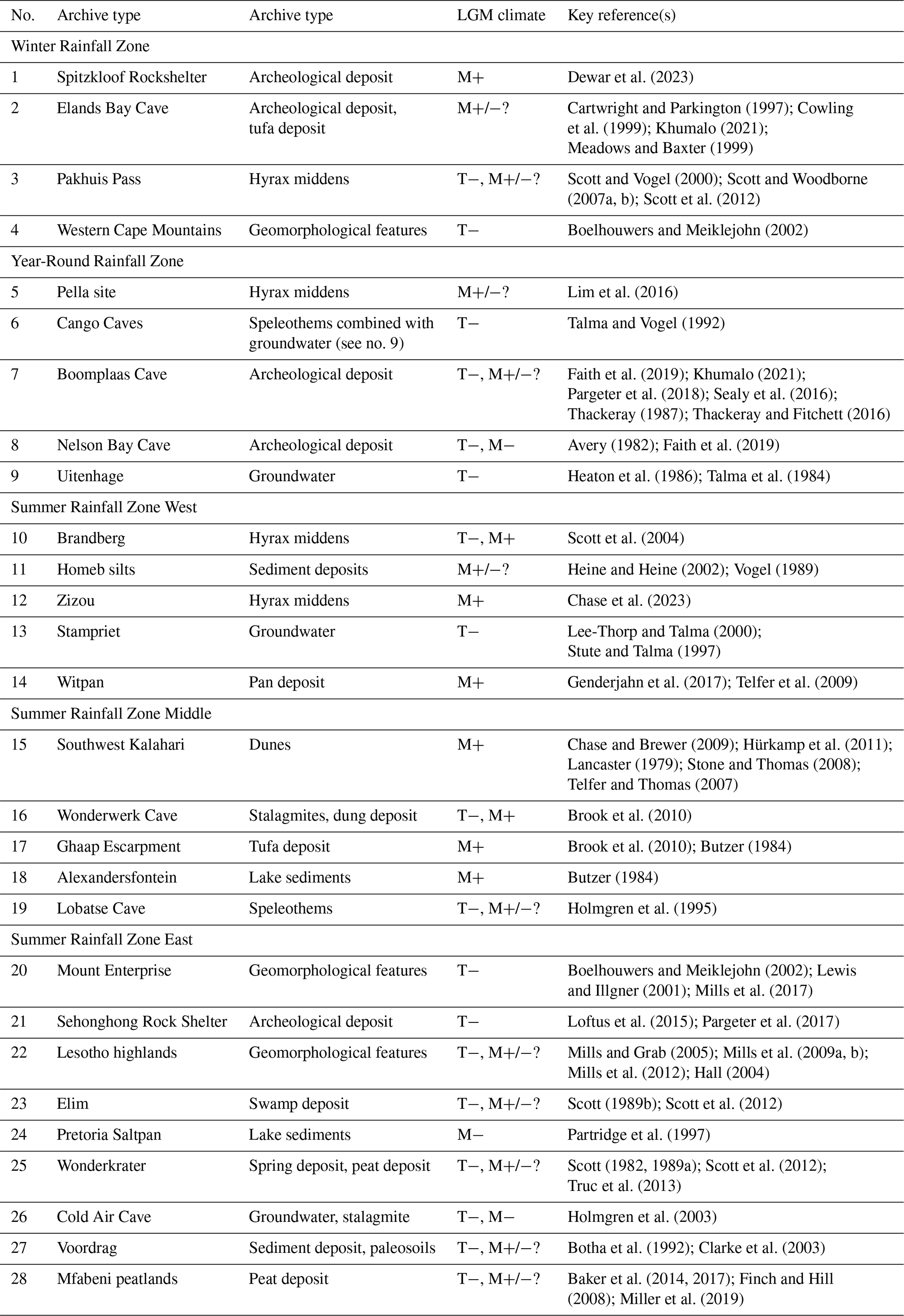
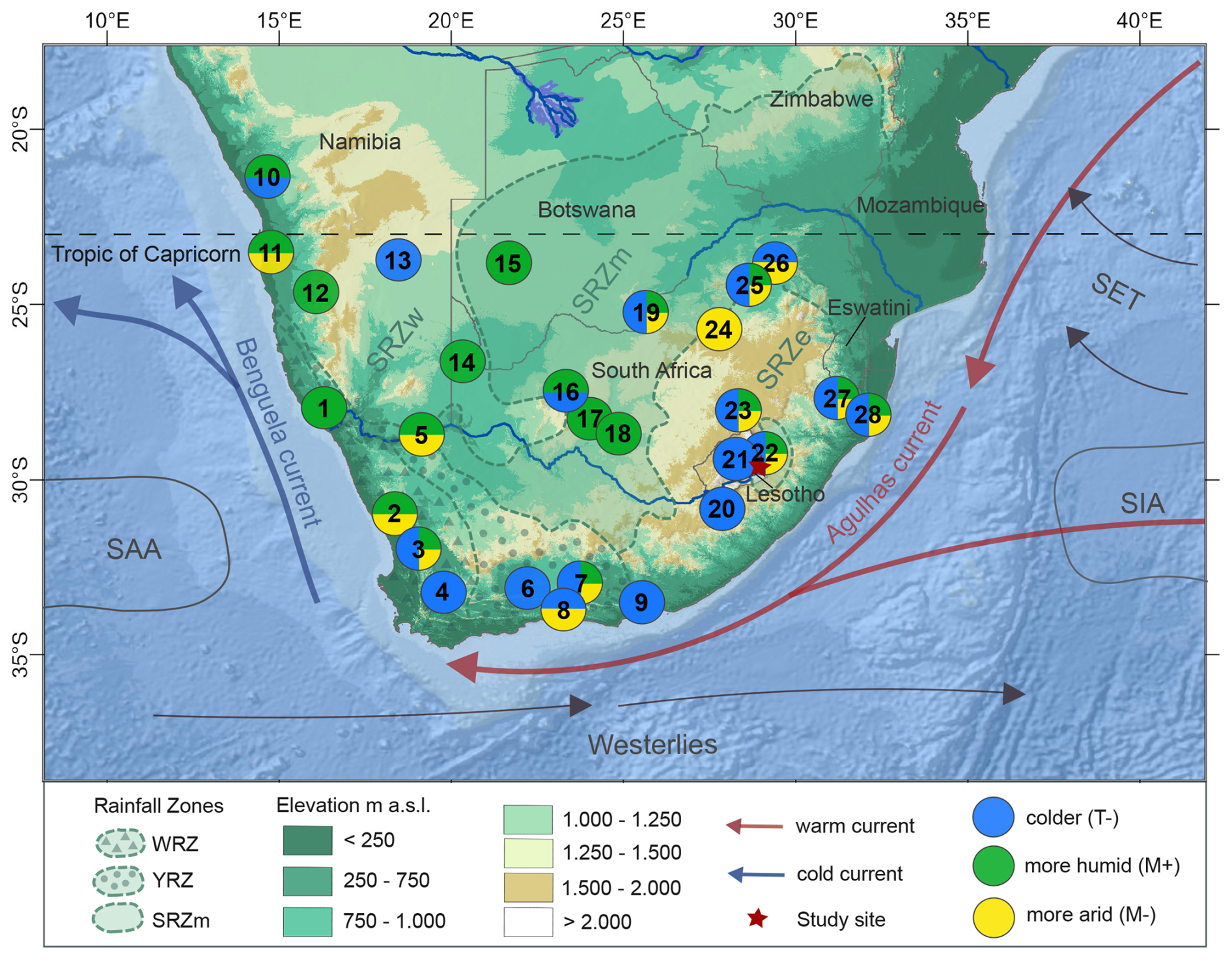
Figure 1Modern climate setting with selected Southern African sites of LGM climate records (1–28 in Table 1). SRZw = Summer Rainfall Zone West; SRZm = Summer Rainfall Zone Middle; SRZe = Summer Rainfall Zone East; WRZ = Winter Rainfall Zone; YRZ = Year-Round Rainfall Zone; SET = Southeast Trades; SAA = South Atlantic Anticyclone; SIA = South Indian Anticyclone; the positions of the climate systems vary seasonally (rainfall zones after Geppert et al., 2022; SRTM elevation data from U.S. Geological Survey, 2014; oceanic layer from ESRI et al., 2014).
In respect to late Quaternary glacials, shifts of oceanic and atmospheric components with different effects on the changes in temperature and precipitation intensity and patterns over Southern Africa are hypothesized (e.g., Chase and Meadows, 2007; Fitchett et al., 2017; Kohfeld et al., 2013; Rojas, 2013; Sime et al., 2013). However, only a few LGM climate records are available to validate these assumptions (see Table 1; Fig. 1).
Although Southern African climate zones are quite diverse, LGM temperatures are generally considered to have been lower than temperatures today. Studies generally indicate a mean annual temperature drop of approximately 6 °C compared to present conditions (e.g., Engelbrecht et al., 2019; Heaton et al., 1986; Holmgren et al., 2003; Scott, 1982). However, the estimated mean annual temperature drop ranges from exceeding 10 °C in the high-altitude regions of the Drakensberg Escarpment (Boelhouwers and Meiklejohn, 2002; Lewis and Illgner, 2001; Partridge et al., 1997) to being around 2 °C in other areas (Holmgren et al., 1995; Stute and Talma, 1997; Lee-Thorp and Talma, 2000; Truc et al., 2013), whereas Scott et al. (2012) suggested a slight warming between 20–19 ka at Pakhuis Pass (Table 1), bringing temperatures closer to present-day levels. Furthermore, precipitation or moisture availability varies across sites, being either lower than, higher than, or similar to present-day levels (Table 1, Fig. 1). This wide value range for temperature and moisture availability reconstruction does not turn out satisfactorily. But the major bias in calculating mean annual temperature and moisture availability may be explained by the different archive types, site locations, and analytical methods as highlighted in Table 1.
Archeological studies of two rock shelters in the lowland of Lesotho (1790 and 1860 m a.s.l.) have demonstrated human occupation during the LGM and that fish was part of livelihoods (Pargeter et al., 2017; Pazan, 2022).
In a phylogeographic study, Sands et al. (2022) demonstrated that some of Lesotho's river systems were active during the LGM. Engelbrecht et al. (2019) scaled global LGM simulations down to Southern Africa and suggested that the temperatures were 4–6 °C lower along the eastern escarpment and that Lesotho received precipitation all year round.
Against this background, the high summits of Lesotho in proximity to the eastern escarpment received particular attention, and six sites with glacial landforms were suggested for this area (Mills and Grab, 2005; Mills et al., 2009a, b, 2012; Fig. 2). Given its extensive discussion in prior studies (Mills and Grab, 2005; Hall, 2010; Hall and Meiklejohn, 2011), we directed our attention towards the Tsatsa-La-Mangaung site among the proposed locations. We considered the moraine interpretation by Mills and Grab (2005) for the ridges at the Tsatsa-La-Mangaung mountain range near Sani Top (Fig. 2a) disputable for the following reasons: (1) the contour lines of Mills and Grab (2005, their Fig. 2) show no indications or morphological correspondence to either a glacier or nivation. (2) Both remote sensing data and Fig. 2 by Mills and Grab (2005) reveal a fault line at the site (see also the Geological Map of Lesotho (Lesotho Government, 1982)). Yet, this aspect was not considered in the process of genesis of the landscape feature. (3) The association between moraine material and the pre-Holocene-dated soil organic matter described in the trenches presents an unclear relationship, marked by petrographic variability.
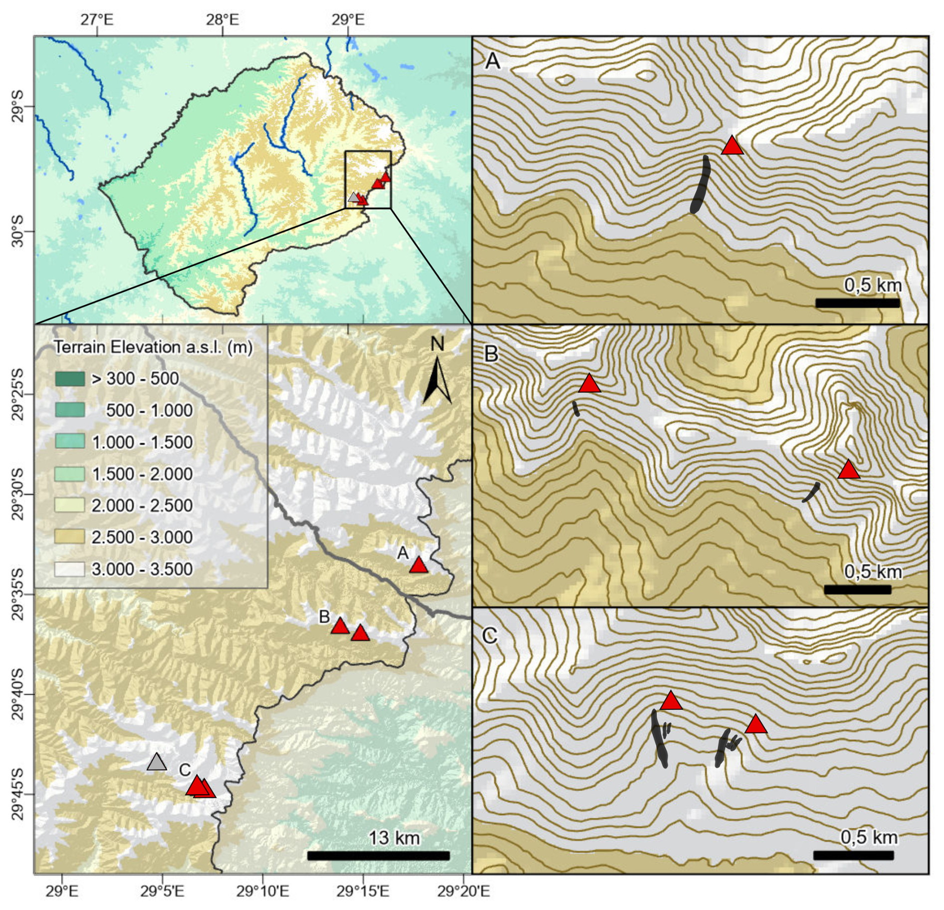
Figure 2Geographic setting (elevation data from U.S. Geological Survey, 2014). (Top left) Location of focal area in Eastern Lesotho. (Bottom left) Triangles show locations with landforms related to glacial processes by Mills and Grab (2005), Mills et al. (2009a, b), and Mills et al. (2012). The grey triangle indicates a site in Mills et al. (2012) based on remote sensing only. (A) Tsatsa-La-Mangaung (revisited by us and representing our study site). (B) Sekhokong Range. (C) Leqooa Valley; equidistance =20 m; positive, ridge-like landforms in black.; SRTM elevation data from U.S. Geological Survey (2014).
We revisited this site to evaluate the moraine interpretation by Mills and Grab (2005). The “moraines” in the Tsatsa-La-Mangaung mountain range have been employed for glacier-based climate reconstruction (Mills et al., 2012). Every glacier-based climate reconstruction should be grounded on securely identified moraines. This is the only landform which has been studied by others in some detail, and the location is in a nowadays hydro-climatologically favorable area, which we assume was the case too during the LGM and thus was favorable for a potential glaciation. Furthermore, due to unfavorable weather and hydrological conditions during our expedition, we could not reach any of the other sites suggested to be moraine-like deposits, which are located far from any roads or passable tracks. Each location requires its own expedition.
The study site is located in Eastern Lesotho (Fig. 2a), within the Upper Triassic to Lower Jurassic Drakensberg plagioclase-rich flood basalt (Haskins and Bell, 1995; Schmitz and Rooyani, 1987). Dolerite dikes are common (Haskins and Bell, 1995). The site lies in proximity to the Sani Top mountain range, outlining the elevated terrain at the head of Sani Pass above the Great Escarpment (Fig. 2b). In this area, elevation ranges from ca. 2800 to 3482 m a.s.l., which is the summit of Thabana-Ntlenyana, the highest mountain of Southern Africa. Valleys are asymmetrically shaped, with south-facing slopes being steeper and shorter than the north-facing slopes (Boelhouwers, 2003; personal observations by the authors).
The moraine-like landform under investigation is located at 29°33′29.37′′ S, 29°17′43.50′′ E, on a south-facing slope of the Tsatsa-La-Mangaung mountain range, ca. 3 km north of the Sani Pass border and 2 km west of the Great Escarpment.
The study site lies within the Summer Rainfall Zone East (SRZe in Geppert et al., 2022). While northern winds are common all year round, the prevailing summer wind comes from the east, transporting moisture from the Indian Ocean (Geppert et al., 2022). In winter, the wind blows predominantly from the west (Sene et al., 1998). Rainfall is mainly due to large-scale line thunderstorms and orographically induced storms (Tyson et al., 1976).
The WorldClim data set estimates mean annual precipitation values of ∼ 1015 mm around Sani Top (Fick and Hijmans, 2017), with 75 % falling from November to March and less than 10 % falling in winter, from May to August, mainly as snow (Nel and Sumner, 2008; Sene et al., 1998). Inter-annual variability in snowfall is high (Wunderle et al., 2016). South-facing slopes above 3250 m a.s.l. receive a maximum amount of snow, which can last several weeks to months (Hanvey and Marker, 1992; Mulder and Grab, 2009; NASA, 2023).
The study area features one of the highest precipitation levels in Southern Africa and the lowest annual temperatures (Fick and Hijmans, 2017; Meque et al., 2022). Temperatures range from a monthly mean of −0.6 °C in July to 8.7 °C in January (Fick and Hijmans, 2017). Temperatures drop below zero regularly, and up to 200 d of ground frost per year is assumed in the study region (Sene et al., 1998). Considering the intense insolation under the mostly cloudless winter sky, diurnal melt–freeze cycles result (Hanvey and Marker, 1992). Rock surface temperatures during winter show a mean of 7.2 °C at a north-facing slope and of −5 °C at a south-facing slope near Sani Top, at 3060 m a.s.l. (Grab, 2007a). Air temperatures on south-facing slopes may decline to −13.5 °C in July (Grab, 2007a). Grab (2007a, b) emphasized a considerable “frost cracking window”. In this context, Boelhouwers and Sumner (2003) reported high block concentrations on south-facing slopes above 3000 m a.s.l. Periglacial processes appear to be limited to the few summit areas above 3400 m a.s.l. (Grab et al., 2021).
The regional regolith cover is generally thin, and soils are poorly developed on slopes. However, alpine vegetation of grass and heath communities is fairly well developed (Mills and Grab, 2005; Grab, 2010; Fig. 3).
Figure 3Geomorphological map of moraine-like landform at Tsatsa-La-Mangaung.
Our field survey at the Tsatsa-La-Mangaung was conducted during March 2022. The field campaign included topographical surveying, geomorphological mapping, and sedimentological prospection. Photo documentation of the study site, accompanied by georeferenced markers, was used to record features and phenomena relevant to substrate and process determination. Furthermore, a DJI Mavic 2 Pro Quadrocopter carrying a Hasselblad L1D-20c camera was employed to obtain high-resolution aerial imagery of the landform and surrounding slopes. Therefore, several different viewing angles were captured. Additionally, geological maps and remote sensing data were examined to assess the presence of dikes. Drone-derived data were processed using the software AgiSoft Metashape Professional (2023). The workflow included the alignment of 37 georeferenced drone photos and placing and verifying markers with nearly 20 000 tie points. A high-resolution dense-cloud and depth map with mild filtering was built. This dense cloud served as the fundamental input data for the construction of a 3D mesh, a crucial component for texture reference. Following this, the digital elevation model (DEM) was computed from the high-resolution dense cloud, and the texture was integrated. Additionally, contours and high-resolution cross sections were derived from the DEM, further enhancing the analysis and visualization capabilities. Google Earth Pro (2022) was employed for verification purposes and for searching further co-occurrences of moraine-like landforms and dikes.
The temporary snow line in the highland of Lesotho was documented by snow cover maps of MODIS on NASA's Terra satellite (NASA, 2018, 2023) and, specifically for the study site, on the ground by photo camera in late July 2022.
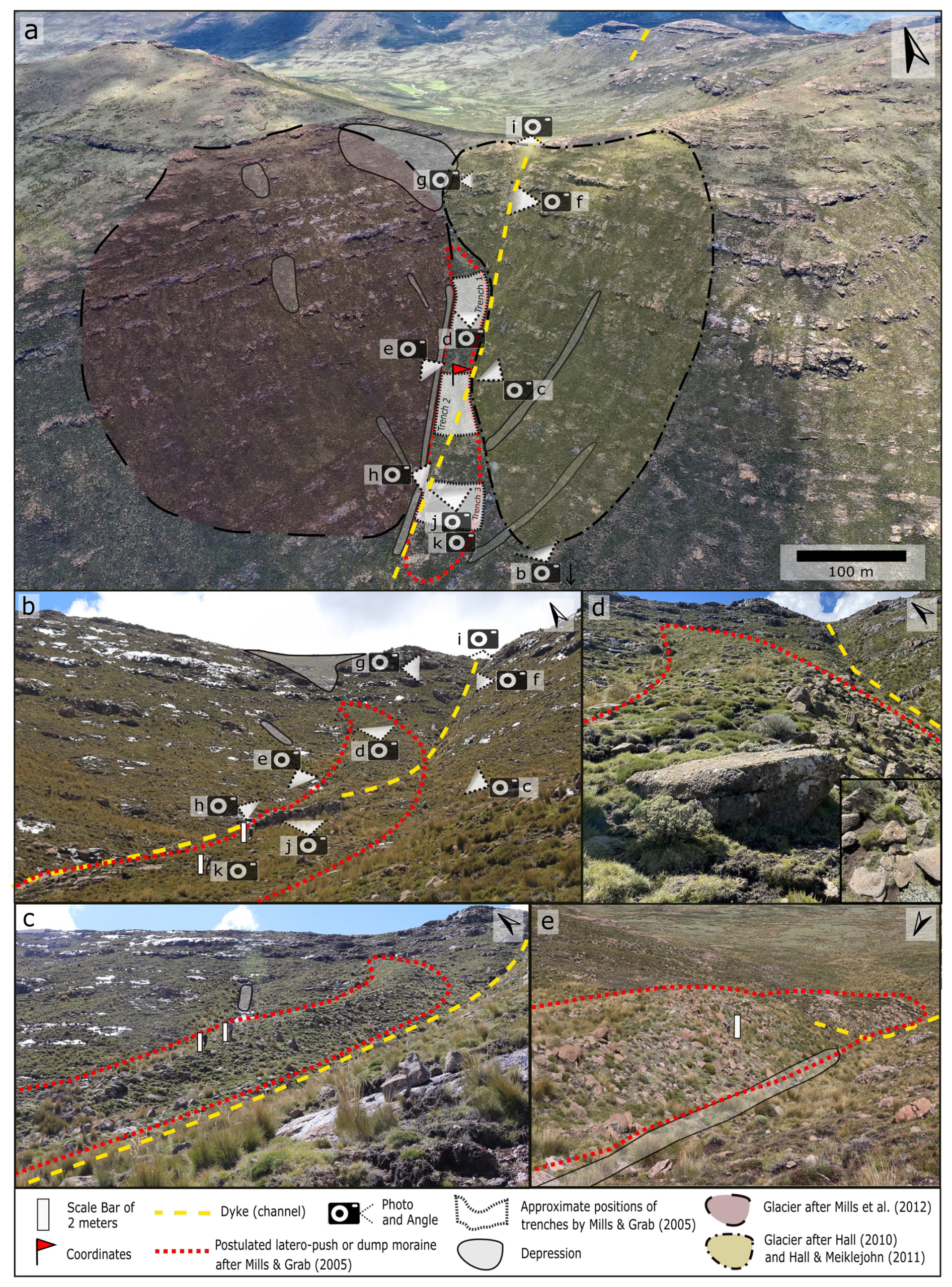
Figure 4(a) High-resolution drone image showing the moraine-like ridge at Tsatsa-La-Mangaung. (b) Ground photo of ridge. (c) Lateral view of the middle and upper ridge. (d) Upper part of the ridge. (e) Lateral view of the middle and lower part of the ridge. Arrows in the upper-right corner of each panel indicate orientation to the north.
The ridge stretches from NNE to SSW, perpendicular to the contour lines, following the gradient (Fig. 3). This feature formed at the junction of two slopes with a mean angle of ∼ 20–22° (∼ 36 %–40 %) facing SSE and SW, respectively (Figs. 4a, 6). Both slopes feature basaltic bedrock outcrops, which, mainly in the upper part, follow a bank-like structure (Figs. 3, 4b–c, 6). These outcrops can also be observed in satellite data above the other postulated moraine sites at the Sekhokong Range (Fig. 2d) and Leqooa Valley (Fig. 2e) (Google Earth Pro, 2022). At Tsatsa-La-Mangaung, block-like weathering has primarily occurred in the upper parts of the slopes (Fig. 5g). Outcrops are more massive, whereas the blocks have mainly diameters ranging from around 0.15 to approximately 2 m, covering both slopes. Weathering of these blocks has added ample numbers of coarse granular clasts to the regolith. A thin soil layer has allowed the growth of grass and heath communities (Fig. 4c).
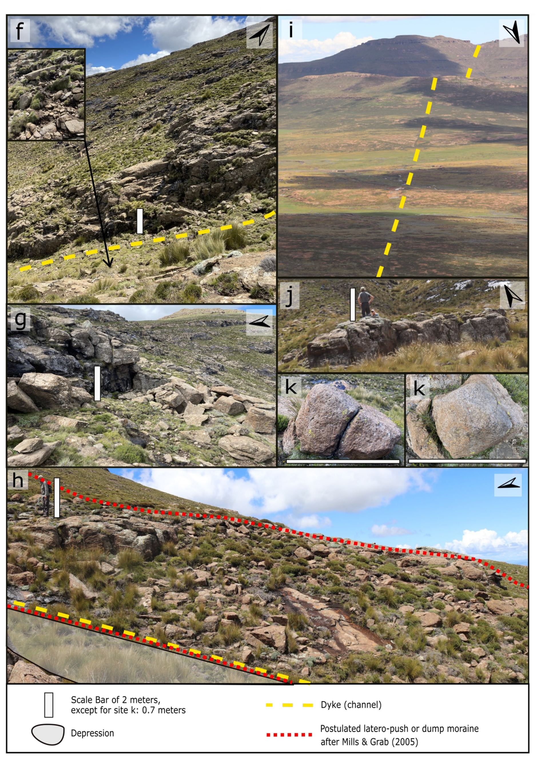
Figure 5(f) The dike channel is deepest along the upper part of the ridge. (g) Block-like weathering on the upper slope. (h) Western flank of the middle to upper section of the ridge. (i) The dike extending to at least neighboring valleys and mountain ranges. (j) Massive stone wall, which is part of the bedrock rib of the ridge. (k) In situ weathering of large blocks within the ridge (see legend for symbols and scales).
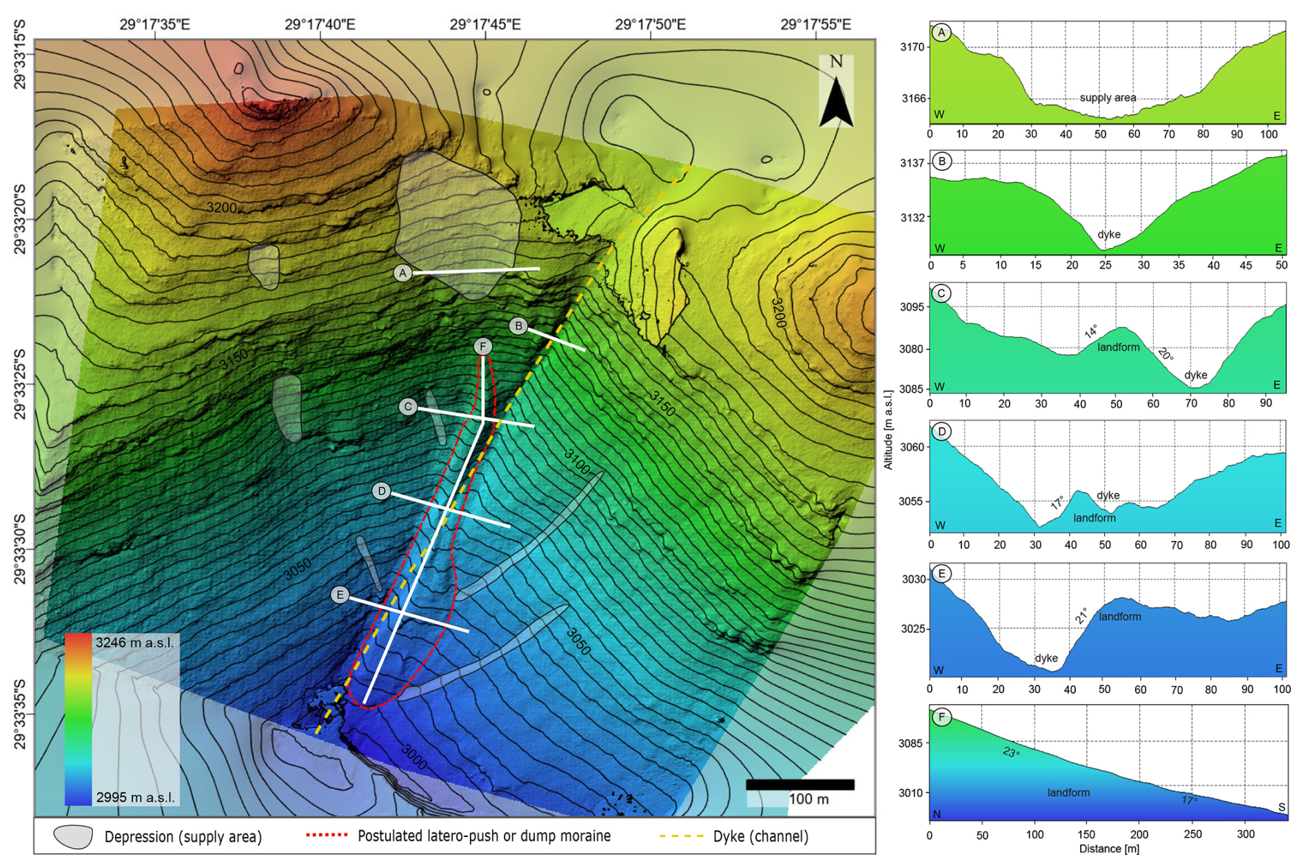
Figure 6Left: high-resolution digital elevation model (DEM) with texture and contour lines derived by drone imagery, showing the study site. (A) Cross section through the major depression above the landform. (B–E) Cross sections at different positions of the dike and the landform. (F) Longitudinal profile through the landform (see legend for symbols).
The studied landform is about 330 m long, descending from ca. 3120 to 3000 m a.s.l. (Fig. 3). The upper section (3090–3120 m a.s.l.) is bent and positioned on the SE-facing slope (Fig. 4a–d). Further down in the middle part (3000–3090 m a.s.l.), the landform becomes rather straight (Fig. 4a, c). At lower elevations (3050–3000 m a.s.l.), it is situated on the SW-facing slope (Figs. 3, 4a, 6). The width of the landform ranges from 12 to 47 m, with a general increase from the upper to the lower section (Figs. 4a, 6). Towards the slope base, the shape of the landform is noticeably more expanded (Figs. 3, 4a, 6, e). A small-scale furrow was identified in the upper and middle parts, widening downslope and delineating a seam within the landform (Fig. 3). The upper portion of the landform has a slope angle of ca. 23° (42 %, 3050–3120 m a.s.l.), while the lower part of the ridge features a slope angle of ca. 17° (30 %, 3000–3050 m a.s.l.) (Fig. 6f).
The base of the landform is a basaltic bedrock rib built up from several bedrock outcrops (Figs. 3, 4b, 5j). In a larger context, it is part of the bank-like-structured outcrops running mainly along the contour lines of the slopes (Figs. 3, 4a, 6). In relation to the landform, the bedrock rib is obvious because of bedrock outcrops in the middle and lower parts (Figs. 3, 4b, 5j, h). In the lower section, for example, a massive rock wall of ca. 2 m height and 15 m length is exposed (Figs. 4b, 5j), stretching between 3020 and 3030 m a.s.l. and facing from northeast (NE) to southwest (SW) and therefore nearly parallel to the contour lines (Figs. 3, 4b, 6). Furthermore, the positive landform consists of blocks and clasts, with sizes similar to the surrounding slopes but in a greater number (Figs. 4c–e, 5h). It encompasses both in situ-weathered material from the bedrock rib and material accumulation from the adjacent slopes, featuring a portion that has also experienced in situ weathering at the location of deposition. The skeletal structure, formed by these larger rocks and blocks, is partially filled in the cavities with loose sediment material containing smaller clasts as well as aggregations of regolith and soil cover (Fig. 4d). There is no noticeable difference in soil properties and vegetation cover at the adjacent slopes. Only the vegetation occurring in the deeper parts of the furrow in the middle part of the landform (Fig. 3) is akin to the denser vegetation found in the depressions along the slopes and within the dike. Whereas the bend in the upper part of the landform primarily represents an accumulation of slope material, blocks on and along the rib in the middle and lower part are the product of in situ-weathered outcrops (Fig. 5h, k).
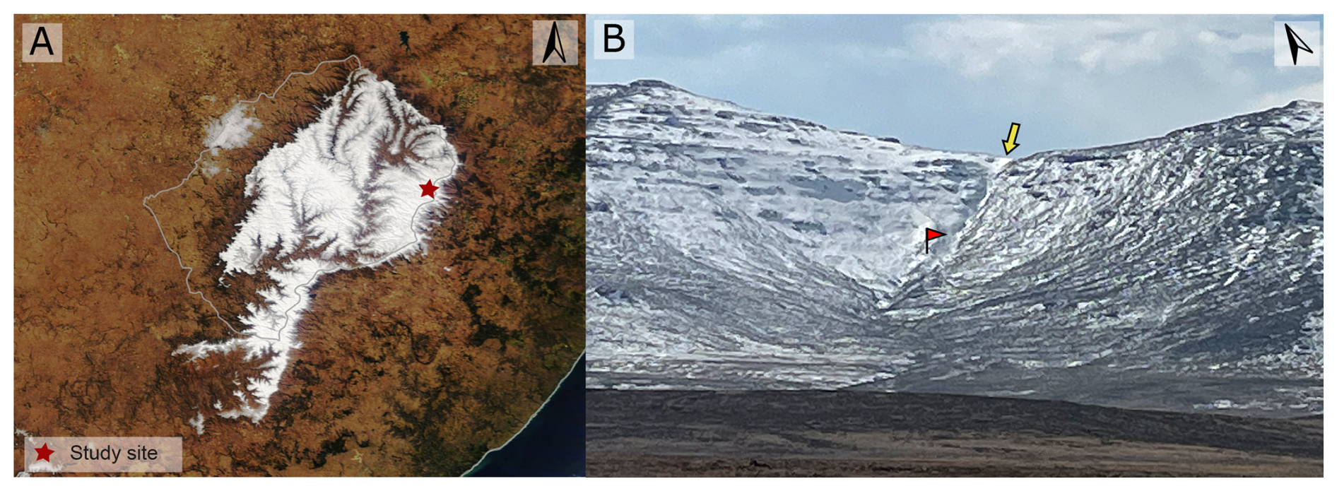
Figure 7(a) Temporary snow line in the highlands of Lesotho on 6 August 2018 (NASA, 2018). (b) Snow cover on Tsatsa-La-Mangaung (photo from 29 July 2022). The flag indicates the position of the moraine-like landform; the arrow points at the snow-filled dike channel.
The adjacent slopes are mainly straight to slightly convex, with some small local depressions (Fig. 6). The uppermost part (ca. 3150–3205 m a.s.l.; mean slope 20.5° (36 %)) of the SW-facing slope exhibits the most significant depression (ca. 0.01 km2) in the study area. It points towards the bent upper section of the moraine-like landform along the steepest gradient (Figs. 4a, 6). Using the high-resolution DEM, mostly shallow, partly channel-like depressions can be identified on both slopes, not above but beside the landform (Figs. 3, 6). In addition, a narrow, channel-like depression runs parallel to the landform's western side (Figs. 3, 4a, 6), becoming more pronounced with declining elevation (Fig. 5c–d). These linear, narrow, channel-like depressions act as drainage pathways after rainfall (observed in March 2022; see Fig. 3). A depression corresponding to a glacier or nival niche could not be identified on either of the slopes, given the presence of massive outcrops (Figs. 3, 4a–c, 5g, 6) and given that it would further be evident in the high-resolution DEM (Fig. 6) as a noticeable depression.
A linear dike from and to neighboring mountain ranges, visible in low-angle field observation and satellite data, features specific vegetation and a channeled erosional structure (Figs. 4a, 5i). On the surrounding mountain ranges to the NNE, it is visible as a channeled depression (Fig. 5a). In the SSW direction, the dike is detectable by the vegetation differing (Fig. 5i). The geology in this area is marked in general by basalt and dike intrusions of different spatial extents, spanning local to regional structures with varying orientations. The dike can also be found at the postulated moraine site Sekhokong (Fig. 2d). At the Tsatsa-La-Mangaung site, the dike trends from NNE to SSW, running perpendicular to the contour lines and along the depth line at the junction of the slopes (Figs. 3, 4a, 6). It joins the moraine-like landform at the landform's transition from bent to straight (ca. 3090 m a.s.l.) (Figs. 3, 4a, c, d, 6). The dike runs parallel to the landform, accentuating its eastern flank, until it cuts the landform's lower section at ca. 3055 m a.s.l. (Figs. 3, 4a, b, 6). At lower elevations, the dike channel, which reaches its maximum width, is situated on the western flank of the landform (Figs. 3, 4a, e, 6e). The lower section of the landform is located on the SW-facing slope and is more radiating, with a width of up to nearly 50 m (Figs. 3, 4a, 6). The channeled structure of the dike indicates that it consists of rock that is more easily weatherable than the adjacent bedrock. In the uphill position, the dike channels are up to 5 m deep (Fig. 6b) and capture surface water flow (field observation, March 2022; see Fig. 3), including snowmelt (Fig. 7b). The relative deep incision at a short distance to the watershed suggests either relatively low erosional resistance of the dike or active faulting. Furthermore, the watershed ridge is formed as a smooth saddle (cf. Fig. 4a) without indicating active faulting. Also, the valley head shows a continuous transition from extensive denudation to fluvial erosion. Together with the relatively high number of smaller-sized clasts within the channel (Fig. 5f), we can carefully assume that the incision is more likely related to more easily weatherable rock types of the dike than the hypothesis of active tectonic processes. Furthermore, the soil layer and vegetation display enhanced density. In the high-resolution cross-sections C–E depicted in Fig. 6, it is evident that the landform rises less than 3 m above the surrounding slope level.
We did not find any indication that the moraine-like landform in the Tsatsa-La-Mangaung mountain range was formed by a glacier (see, e.g., Hall, 2010; Hall and Meiklejohn, 2011; Mills and Grab, 2005; Mills et al., 2012). We interpret the identified bedrock rib as a barrier where material from the upper slope could accumulate. The accumulated blocks and clasts are mainly found in the upper section of the landform, which has created the bent extension of the bedrock rib. We could identify the corresponding supply area of ca. 0.01 km2 (Fig. 6), with the steepest gradient trending towards the central accumulation zone. This co-occurrence is in phase due to the lack of evidence of a downslope landform that could represent a terminal moraine. Other supply areas (Figs. 4a, 6) are much smaller and directed towards the lower parts of the landform, explaining why less slope material has been deposited there; however, they contribute to the downslope broadening of the landform. Part of the blocks represent in situ weathering of the bedrock rib or deposited rocks and blocks (Fig. 5k). The primary source area of the blocks and clasts which have accumulated at the upper section of the bedrock rib represents the only larger depression on the two adjacent slopes (Fig. 6). Therefore, the glacier locations sketched by Hall (2010) and Hall and Meiklejohn (2011) for the SW-facing slope and by Mills et al. (2012) for the SSE-facing slope show no geomorphological match (Fig. 4a), except for the bent block and clast accumulation at the upper section of the landform, which is clearly not of glacial origin. Small glaciation and a short lifespan of glaciers were presented by Mills and Grab (2005) as arguments for not causing substantial erosion and depositional remnants, which were already discussed in Hall (2010) and Knight (2012). Nevertheless, a glacier that lays down a moraine would grind at least the area. But there is no evidence of glacial abrasion; in contrast, there is strongly weathered micro-relief, which would not have withstood glacial processes. Furthermore, we found sharp bank-like bedrock outcrops (Figs. 3, 4a–c, 6) and convex forms over the vast extent of both slopes (Fig. 6, also mentioned in Hall, 2010). These findings are consistent with the uniform contour lines, which show no significant depressions, presented in Fig. 2 by Mills and Grab (2005). In summary, we could not identify signs of glacial erosion or a nival niche deep and large enough in which a glacier could have developed.
The three trenches described by Mills and Grab (2005) (Fig. 4a) align with our findings. However, they primarily consist of diamictic material in the form of larger rocks and blocks, which is indicative of rockfall, obviously to be expected by the uphill slope and rock wall stairs. The subsequent infilling with colluvial fine material and weathering processes, along with post-sedimentological accumulation of fine soil particles due to soil development, contribute to the formation of the observed soil profiles. Nevertheless, we cannot contextualize these profiles with evidence of glacial deposits. The original dating of soil organic matter by Mills and Grab (2005) from depths between 1.35 and 1.5 m in the trenches indicates that these local pits developed during the pre-Holocene period, covering a period of nearly 7 ka. This supports the hypothesis of a sequential accumulation of the landform, resulting from several successive events.
Mills and Grab (2005) provided a review and a discussion of potential underlying processes, which made them conclude that a glacial moraine represents the most likely interpretation of the landform. We agree with their sedimentological analysis that particle properties are not exactly typical of debris flows, but we suggest small-scale debris flows likely occurred. This is against the background that we measured a slope angle of 23° above the landform, which is steep enough to initiate debris flow (Iverson et al., 1997), while Mills and Grab (2005) wrote that the angle has to exceed 27°. In this context, it is noteworthy that the highlands of Lesotho are tectonically active (Cherry, 1996). Mills and Grab (2005) admitted that the little-sorted, dominantly angulated clasts found at the landform are characteristic of pronival ramparts (Hall and Meiklejohn, 1997), but following their own conclusion that no debris flow could have occurred, they excluded the possibility that the moraine-like structure was solely formed by erosional gravitational processes. Instead, they interpreted debris-flow-like sediment components as supraglacially derived (Mills and Grab, 2005). We doubt the validity of the idea of supraglacial transport because a potential glacier would have formed just below the culmination (cf. Fig. 4a in Mills et al., 2012, and Fig. 4a in this paper), and thus there would have been only a small source area of clasts. Furthermore, we find the assumption of Mills and Grab (2005) that coarser debris can flow onto a glacier but not along an ice-free slope questionable. Benn and Ballantyne (1994) suggested that differentiation between moraine material and frost-weathered scree by the aggregated class roundness index cannot be evidenced. The latter suggestion is in line with our interpretation.
Frost weathering is considered to be pronounced at the study site, with its terrain above ca. 2900 m a.s.l. termed sub-periglacial (sensu Karte, 1983) by Marker (1992). This classification includes extended seasonal diurnal freeze–thaw cycles. In Fig. 7b the snow line runs almost exactly along the 2900 m contour line. During cold spells the snow cover can be sustained at elevation a few hundred meters lower (Fig. 7a). The accumulation of snow at the study site is enhanced in the depressions including the dike channel (arrow in Fig. 7b). The availability of meltwater is thus higher and the frost cracking more intense.
Furthermore, a linear dike structure is evident at the Tsatsa-La-Mangaung site, extending to both sides and reaching the Sekhokong site in the SSE direction (Fig. 2d; Lesotho Government, 1982). At the Tsatsa-La-Mangaung site, a channel-like depression combined with the dike channel shaped and accentuated the landform by erosion (Figs. 4a, 6). After the landform deposition, the narrow, channel-like depression developed parallel to its western flank, as precipitation and meltwater began to preferentially drain down beside the landform (observed after rainfall in March 2022; see Fig. 3). Alongside the dike channel, which also collects surface water (observed in March 2022; see Fig. 3), the form is accentuated on both sides through enhanced weathering processes and fluvial erosion. This is particularly evident in the cross sections in Fig. 6c–e. The dike channel therefore contributes to the landform's development and shape, deepening the eastern flank in the upper part of the landform by erosion and increasing its slope gradient (Fig. 6c). The resulting asymmetrical slope is therefore no indication for a latero-push or dump moraine as suggested by Mills and Grab (2005). In summary, the sedimentological parameters presented by Mills and Grab (2005) are not mandatory for glacial deposits (cf., e.g., Bennett et al., 1999). They assume appropriate erosional features, but no morphological evidence for glacier erosion could be presented for this site. Finally, the discussed sedimentological properties are not designed to prove glacial accumulation on such small scales (cf., e.g., Benn and Ballantyne, 1994, among others).
Five other sites in Eastern Lesotho have been considered to show glacial landforms (Mills and Grab, 2005; Mills et al., 2009a, b, 2012; Fig. 2). They have, in common with our study site, an altitude above 3000 m, and the four ground-investigated sites show assumed moraines, which are also oriented perpendicular to the contour lines following the gradient of south-facing slopes (Fig. 2d–e). The Sekhokong (Fig. 2d) and Leqooa Valley (Fig. 2e) sites furthermore also show an absence of irregularities in contour lines above the formations, as illustrated in the morphological maps by Mills and Grab (2005) and Mills et al. (2009a) in their Figs. 4 and 3, respectively. Google Earth Pro (2022) imagery further confirms the presence of substantial bedrock outcrops above the landscape features at these additional sites. High-resolution digital elevation models are crucial for accurately analyzing and interpreting the described landforms at the investigated locations. Furthermore, for the Sekhokong site (Fig. 2d), it is essential to incorporate the influence of dike structures outlined in the Geological Map of Lesotho (Lesotho Government, 1982) on the formation of the landscape features. Whether these landforms can be explained by processes other than glacial processes will remain unanswered until these sites are re-investigated. Moreover, the interior of the highland is understudied, and a detailed landscape analysis is needed to discuss whether LGM temperatures were low enough for glaciers to form.
The image data and derived DEM can be requested from the corresponding author.
FR, KH, and VB conducted the field survey and data collection. JM was essential in supporting the fieldwork by organizing the flight permit for the drone. VB performed the data analyses. The interpretation of the data presented in this scientific publication was conducted collaboratively by VB, MB, KH, and FR. VB wrote the initial manuscript with support from all other authors. KH conducted the revision process.
The contact author has declared that none of the authors has any competing interests.
Publisher’s note: Copernicus Publications remains neutral with regard to jurisdictional claims made in the text, published maps, institutional affiliations, or any other geographical representation in this paper. While Copernicus Publications makes every effort to include appropriate place names, the final responsibility lies with the authors. Views expressed in the text are those of the authors and do not necessarily reflect the views of the publisher.
We want to thank the air traffic controllers at Moshoeshoe I International Airport of Lesotho for the permission to fly the drone. Jana Frenzel greatly assisted us during the field survey and with data documentation. Thanks also go to Jan Evers for his contribution to enhancing the quality of the graphics. We are grateful to the Deutsche Forschungsgemeinschaft for financial support. Venise Bayer's participation in this study was made possible by the Evangelisches Studienwerk e.V. Villigst scholarships, and she sincerely appreciates the financial aid. The drone used in this research was funded by the women's promotion program of the Department of Earth Sciences at the Freie Universität Berlin.
This research has been supported by the Deutsche Forschungsgemeinschaft (grant no. RI 809/38) and the Evangelisches Studienwerk e.V. Villigst.
The article processing charges for this open-access publication were covered by the Freie Universität Berlin.
This paper was edited by Christopher Lüthgens and Gilles Rixhon and reviewed by two anonymous referees.
AgiSoft Metashape Professional: Multi-view 3D reconstruction, version 2.0.1., [Computer software], http://www.agisoft.com/downloads/installer/ (last access: 28 October 2025), 2023.
Avery, D. M.: The micromammalian fauna from Border Cave, Kwazulu, South Africa, Journal of Archaeological Science, 9, 187–204, https://doi.org/10.1016/0305-4403(82)90049-8, 1982.
Baker, A., Routh, J., Blaauw, M., and Roychoudhury, A. N.: Geochemical records of palaeoenvironmental controls on peat forming processes in the Mfabeni peatland, Kwazulu Natal, South Africa since the Late Pleistocene, Palaeogeography, Palaeoclimatology, Palaeoecology, 395, 95–106, https://doi.org/10.1016/j.palaeo.2013.12.019, 2014.
Baker, A. Pedentchouk, N., Routh, J., and Roychoudhury, A. N.: Climatic variability in Mfabeni peatlands (South Africa) since the late Pleistocene, Quaternary Science Reviews, 160, 57–66, https://doi.org/10.1016/j.quascirev.2017.02.009, 2017.
Benn, D. I. and Ballantyne, C. K.: Reconstructing the transport history of glaciogenic sediments: a new approach based on the co-variance of clast shape indices, Sedimentary Geology, 91, 215–227, https://doi.org/10.1016/0037-0738(94)90130-9, 1994.
Bennett, M. R., Waller, R. I., Glasser, N. F., Hambrey, M. J., and Huddart, D.: Glacigenic clast fabrics: genetic fingerprint or wishful thinking?, Journal of Quaternary Science, 14, 125–135, https://doi.org/10.1002/(SICI)1099-1417(199903)14:2<125::AID-JQS426>3.0.CO;2-0, 1999.
Boelhouwers, J. C.: Quaternary slope development in the Lesotho highlands: review and alternative model: research in action, South African journal of science, 99, 44–46, 2003.
Boelhouwers, J. C. and Meiklejohn, K. I.: Quaternary periglacial and glacial geomorphology of southern Africa: review and synthesis: Periglacial and Permafrost Research in the Southern Hemisphere, South African Journal of Science, 98, 47–55, 2002.
Boelhouwers, J. C. and Sumner, P. D.: The palaeoenvironmental significance of southern African blockfields and blockstreams, Permafrost, Swets and Zeitlinger, Lisse, 73–78, 2003.
Botha, G. A., Scott, L., Vogel, J. C., and von Brunn, V.: Palaeosols and palaeoenvironments during the “Late Pleistocene Hypothermal” in Northern Natal, South African Journal of Science, 88, 508–512, 1992.
Braconnot, P., Harrison, S. P., Kageyama, M., Bartlein, P. J, Masson-Delmotte, V., Abe-Ouchi, A., Otto-Bliesner, B., and Zhao, Y.: Evaluation of climate models using palaeoclimatic data, Nature Climate Change, 2, 417–424, https://doi.org/10.1038/nclimate1456, 2012.
Brook, G. A., Scott, L., Railsback, L. B., and Goddard, E. A.: A 35ka pollen and isotope record of environmental change along the southern margin of the Kalahari from a stalagmite and animal dung deposits in Wonderwerk Cave, South Africa, Journal of Arid Environments 74, 870–884, https://doi.org/10.1016/j.jaridenv.2009.11.006, 2010.
Butzer, K. W.: Late Quaternary environments in South Africa, Late Cainozoic palaeoclimates of the Southern Hemisphere. International symposium held by the South African Society for Quaternary Research, Swaziland, 29 August 1983, 235–264, 1984.
Cartwright, C. and Parkington, J.: The wood charcoal assemblages from Elands Bay Cave, southwestern Cape: principles, procedures and preliminary interpretation, The South African Archaeological Bulletin, 59–72, https://doi.org/10.2307/3888977, 1997.
Chabangborn, A., Brandefelt, J., and Wohlfarth, B.: Asian monsoon climate during the Last Glacial Maximum: palaeo-data-model comparisons, Boreas, 43, 220–242, https://doi.org/10.1111/bor.12032, 2013.
Chase, B. M. and Brewer, S.: Last Glacial Maximum dune activity in the Kalahari Desert of southern Africa: observations and simulations, Quaternary Science Reviews, 28, 301–307, https://doi.org/10.1016/j.quascirev.2008.10.008, 2009.
Chase, B. M. and Meadows, M. E.: Late Quaternary dynamics of southern Africa's winter rainfall zone, Earth-Science Reviews, 84, 103–138, https://doi.org/10.1016/j.earscirev.2007.06.002, 2007.
Chase, B. M., Boom, A., Carr, A. S., Meadows, M. E., and Lim, S.: A ca. 39 000-year record of vegetation and climate change from the margin of the Namib Sand Sea, Quaternary Research, 1–11, https://doi.org/10.1017/qua.2023.29, 2023.
Cherry, M.: Tectonic rift “may threaten”Lesotho dam, Nature, 380, 193, https://doi.org/10.1038/380193a0, 1996.
Clark, P. U., Dyke, A. S., Shakun, J. D., Carlson, A. E., Clark, J., Wohlfarth, B., Mitrovica, J. X., Hostetler, S. W., and McCabe, A. M.: The last glacial maximum, Science, 325, 710-714, https://doi.org/10.1126/science.1172873, 2009.
Clarke, M. L., Vogel, J. C., Botha, G. A., and Wintle, A. G.: Late Quaternary hillslope evolution recorded in eastern South African colluvial badlands, Palaeogeography, Palaeoclimatology, Palaeoecology, 197, 199–212, https://doi.org/10.1016/S0031-0182(03)00461-9, 2003.
Cowling, R. M., Cartwright, C. R., Parkington, J. E., and Allsopp, J. C.: Fossil wood charcoal assemblages from Elands Bay Cave, South Africa: implications for Late Quaternary vegetation and climates in the winter-rainfall fynbos biome, Journal of Biogeography, 26, 367–378, https://doi.org/10.1046/j.1365-2699.1999.00275.x, 1999.
Dewar, G., Mackay, A., and Stewart, B. A.: Spitzkloof A Rockshelter, South Africa: Handbook of Pleistocene Archaeology of Africa, Springer, Cham, 1677–1690, https://doi.org/10.1007/978-3-031-20290-2_110, 2023.
Du, Y., Brown, J. R., and Sniderman, J. M. K.: Last Glacial Maximum climate and atmospheric circulation over the Australian region from climate models, Clim. Past, 20, 393–413, https://doi.org/10.5194/cp-20-393-2024, 2024.
Dubey, B. B.: Historical and cultural encyclopedia of Uttar Pradesh, New Delhi, Innovative Imprint, 480 pp., ISBN 9788195669288, 2023.
Engelbrecht, F. A., Marean, C. W., Cowling, R. M., Engelbrecht, C. J., Neumann, F. H., Scott, L., Nkoana, R., O'Neal, D., Fisher, E., Shook, E., and Franklin, J.: Downscaling last glacial maximum climate over southern Africa, Quaternary Science Reviews, 226, 105879, https://doi.org/10.1016/j.quascirev.2019.105879, 2019.
ESRI, GEBCO, NOAA, GARMIN, HERE, et al.: World Oceanic base, https://www.arcgis.com/home/item.html?id=1e126e7520f9466c9ca28b8f28b5e500# (last access: 17 April 2023), 2014.
Faith, J. T., Chase, B. M., and Avery, D. M.: Late Quaternary micromammals and the precipitation history of the southern Cape, South Africa, Quaternary Research, 91, 848–860, https://doi.org/10.1017/qua.2018.105, 2019.
Fick, S. E. and Hijmans, R. J.: WorldClim 2: new 1-km spatial resolution climate surfaces for global land areas, International Journal of Climatology, 37, 4302–4315, https://doi.org/10.1002/joc.5086, 2017.
Finch, J. M. and Hill, T. R.: A late Quaternary pollen sequence from Mfabeni Peatland, South Africa: Reconstructing forest history in Maputaland, Quaternary Research, 70, 442–450, https://doi.org/10.1016/j.yqres.2008.07.003, 2008.
Fitchett, J. M., Grab, S. W., Bamford, M. K., and Mackay, A. W.: Late Quaternary research in southern Africa: progress, challenges and future trajectories, Transactions of the Royal Society of South Africa, 72, 280–293, https://doi.org/10.1080/0035919X.2017.1297966, 2017.
Gasse, F., Chalié, F., Vincens, A., Williams, M. A., and Williamson, D.: Climatic patterns in equatorial and southern Africa from 30,000 to 10,000 years ago reconstructed from terrestrial and near-shore proxy data, Quaternary Science Reviews, 27, 2316–2340, https://doi.org/10.1016/j.quascirev.2008.08.027, 2008.
Genderjahn, S., Alawi, M., Kallmeyer, J., Belz, L., Wagner, D., and Mangelsdorf, K.: Present and past microbial life in continental pan sediments and its response to climate variability in the southern Kalahari, Organic Geochemistry 108, 30–42, https://doi.org/10.1016/j.orggeochem.2017.04.001, 2017.
Geppert, M., Riedel, F., Gummersbach, V. S., Gutjahr, S., Hoelzmann, P., Reyes Garzón, M. D., Shemang, E. M., and Hartmann, K.: Late Pleistocene hydrological settings at world heritage Tsodilo Hills (NW Kalahari, Botswana), a site of ancient human occupation, Quaternary Science Advances, 3, 100022, https://doi.org/10.1016/j.qsa.2021.100022, 2021.
Geppert, M., Hartmann, K., Kirchner, I., Pfahl, S., Struck, U., and Riedel, F.: Precipitation Over Southern Africa: Moisture Sources and Isotopic Composition, JGR Atmospheres, 127, e2022JD037005, https://doi.org/10.1029/2022JD037005, 2022.
Google Earth Pro: version 7.3.6., https://www.google.com/intl/de/earth/about/versions/#earth-pro (last access: 28 October 2025), 2022.
Grab, S. W.: Near-surface rockwall temperatures in high Drakensberg basalt: spatio-temporal differences and possible implications for weathering, Zeitschrift für Geomorphologie, 51, 103–113, https://doi.org/10.1127/0372-8854/2007/0051S-0103, 2007a.
Grab, S.: Rock-surface temperatures of basalt in the drakensberg alpine environment, Lesotho, Geografiska Annaler: Series A, Physical Geography, 89, 185–193, https://doi.org/10.1111/j.1468-0459.2007.00317.x, 2007b.
Grab, S., Knight, J., Mol, L., Botha, T., Carbutt, C., and Woodborne, S.: Periglacial landforms in the high Drakensberg, Southern Africa: morphogenetic associations with rock weathering rinds and shrub growth patterns, Geografiska Annaler: Series A, Physical Geography, 103, 1–24, https://doi.org/10.1080/04353676.2020.1856625, 2021.
Grab, S. W.: Alpine turf exfoliation pans in Lesotho, southern Africa: Climate-process-morphological linkages, Geomorphology, 114, 261–275, https://doi.org/10.1016/j.geomorph.2009.07.007, 2010.
Hall, K.: Glaciation in southern Africa, Developments in Quaternary Sciences, 2, 337–338, https://doi.org/10.1016/S1571-0866(04)80139-8, 2004.
Hall, K.: The shape of glacial valleys and implications for southern African glaciation, South African Geographical Journal, 92, 35–44, https://doi.org/10.1080/03736245.2010.485360, 2010.
Hall, K. and Meiklejohn, I.: Some observations regarding protalus ramparts, Permafrost and Periglacial Processes, 8, 245–249, https://doi.org/10.1002/(SICI)1099-1530(199732)8:2<245::AID-PPP246>3.0.CO;2-R, 1997.
Hall, K. and Meiklejohn, I.: Glaciation in southern Africa and in the sub-Antarctic, Developments in Quaternary Sciences, 15, 1081–1085, https://doi.org/10.1016/B978-0-444-53447-7.00078-7, 2011.
Hanvey, P. M. and Marker, M. E.: Present-day periglacial microforms in the High Drakensberg and Lesotho: implications for present and past conditions. Permafrost and Periglacial Processes, 3, 353–361, https://doi.org/10.1002/ppp.3430030409, 1992.
Haskins, D. R. and Bell, F. G.: Drakensberg basalts: their alteration, breakdown and durability, Quarterly Journal of Engineering Geology, 28, 287–302, https://doi.org/10.1144/gsl.qjegh.1995.028.p3.07, 1995.
Heaton, T. H. E., Talma, A. S., and Vogel, J. C.: Dissolved Gas Paleotemperatures and 18O Variations Derived from Groundwater near Uitenhage, South Africa, Quaternary Research, 25, 79–88, 1986.
Heine, K. and Heine, J. T.: A paleohydrologic reinterpretation of the Homeb Silts, Kuiseb River, central Namib Desert (Namibia) and paleoclimatic implications, Catena, 48, 107–130, https://doi.org/10.1016/S0341-8162(02)00012-7, 2002.
Holmgren, K., Karlén, W., and Shaw, P. A.: Paleoclimatic Significance of the Stable Isotopic Composition and Petrology of a Late Pleistocene Stalagmite from Botswana, Quaternary Research, 43, 320–328, https://doi.org/10.1006/qres.1995.1038, 1995.
Holmgren, K., Lee-Thorp, J. A., Cooper, G. R., Lundblad, K., Partridge, T. C., Scott, L., Sithaldeen, R., Talma, A. S., and Tyson, P. D.: Persistent millennial-scale climatic variability over the past 25,000 years in Southern Africa, Quaternary Science Reviews, 22, 2311–2326, https://doi.org/10.1016/S0277-3791(03)00204-X, 2003.
Hughes, P. D. and Gibbard, P. L.: A stratigraphical basis for the Last Glacial Maximum (LGM), Quaternary International, 383, 174–185, https://doi.org/10.1016/j.quaint.2014.06.006, 2015.
Hürkamp, K., Völkel, J., Heine, K., Bens, O., Leopold, M., and Winkelbauer, J.: Late Quaternary environmental changes from aeolian and fluvial geoarchives in the southwestern Kalahari, South Africa: implications for past African climate dynamics, South African Journal of Geology, 114, 459–474, https://doi.org/10.2113/gssajg.114.3-4.459, 2011.
Iverson, R. M., Reid, M. E., and Lahusen, R.: Debris-flow mobilization from landslides, Annual Review of Earth and Planetary Sciences, 25, 85–138, https://doi.org/10.1146/annurev.earth.25.1.85, 1997.
Karte, J.: Periglacial phenomena and their significance as climatic and edaphic indicators, GeoJournal, 7, 329–340, https://doi.org/10.1007/BF00241455, 1983.
Khumalo, W.: Using the fossil charcoal and pollen records from Elands Bay Cave and Boomplaas Cave, South Africa, to reconstruct variability in local hydroclimate and seasonality, PhD thesis, Faculty of Science, Department of Geological Sciences, University of Cape Town, Master Thesis, http://hdl.handle.net/11427/37543, 2021.
Kim, S. J., Crowley, T. J., Erickson, D. J., Govindasamy, B., Duffy, P. B., and Lee, B. Y.: High-resolution climate simulation of the last glacial maximum, Climate Dynamics, 31, 1–16, https://doi.org/10.1007/s00382-007-0332-z, 2007.
Knight, J.: The shape of glacial valleys: comment on Hall (2010), South African Geographical Journal, 94, 1–3, https://doi.org/10.1080/03736245.2012.663953, 2012.
Kohfeld, K. E., Graham, R. M., Boer, A. M. de, Sime, L. C., Wolff, E. W., Le Quéré, C., and Bopp, L.: Southern Hemisphere westerly wind changes during the Last Glacial Maximum: paleo-data synthesis, Quaternary Science Reviews, 68, 76–95, https://doi.org/10.1016/j.quascirev.2013.01.017, 2013.
Kylander, M. E., Holm, M., Fitchett, J., Grab, S., Martinez Cortizas, A., Norström, E., and Bindler, R.: Late glacial (17,060–13,400 cal yr BP) sedimentary and paleoenvironmental evolution of the Sekhokong Range (Drakensberg), southern Africa, PLOS ONE, 16, 1–29, https://doi.org/10.1371/journal.pone.0246821, 2021.
Lancaster, I. N.: Evidence for a widespread late Pleistocene humid period in the Kalahari, Nature, 279, 145–146, https://doi.org/10.1038/279145a0, 1979.
Lee-Thorp, J. A. and Talma, A. S.: Stable light isotopes and past environments in the Southern African Quaternary, in: The Cenozoic of Southern Africa, Oxford Monographs on Geology and Geophysics 40, edited by: Partridge, T. C. and Maud, R. R., ISBN 13: 978-0195125306, Oxford University Press, New York, 236–251, 2000.
Lesotho Government: Geological Map of Lesotho, 1:250 000, Series: Les Geol 250, Sheet North, Edition: 1-D.O.S. 82/821763 S, 1982.
Lewis, C. A. and Illgner, P. M.: Late Quaternary glaciation in Southern Africa: moraine ridges and glacial deposits at Mount Enterprise in the Drakensberg of the Eastern Cape Province, South Africa, Journal of Quaternary Science, 16, 365–374, https://doi.org/10.1002/jqs.610, 2001.
Lim, S., Chase, B. M., Chevalier, M., and Reimer, P. J.: 50 000 years of vegetation and climate change in the southern Namib Desert, Pella, South Africa, Palaeogeography, Palaeoclimatology, Palaeoecology, 451, 197–209, https://doi.org/10.1016/j.palaeo.2016.03.001, 2016.
Loftus, E., Stewart, B. A., Dewar, G., and Lee-Thorp, J.: Stable isotope evidence of late MIS 3 to middle Holocene palaeoenvironments from Sehonghong Rockshelter, eastern Lesotho, Journal of Quaternary Science, 30, 805–816, https://doi.org/10.1002/jqs.2817, 2015.
Ludwig, P. and Hochman, A.: Last glacial maximum hydro-climate and cyclone characteristics in the Levant: a regional modelling perspective, Environmental Research Letters, 17, 14053, https://doi.org/10.1088/1748-9326/ac46ea, 2022.
Mark, B. G. and Osmaston, H. A.: Quaternary glaciation in Africa: key chronologies and climatic implications, Journal of Quaternary Science: Published for the Quaternary Research Association, 23, 589-608, https://doi.org/10.1002/jqs.1222, 2008.
Marker, M. E.: The evidence for cirque glaciation in Lesotho, Permafrost and Periglacial Processes, 2, 21–30, https://doi.org/10.1002/ppp.3430020106, 1991.
Marker, M. E.: Periglacial landforms of southern Africa compared with those of Colorado and New Mexico, USA, South AfricanGeographical Journal, 74, 8–12, https://doi.org/10.1080/03736245.1992.10586388, 1992.
Meadows, M. E. and Baxter, A. J.: Late Quaternary Palaeoenvironments of the southwestern Cape, South Africa: a regional synthesis, Quaternary International, 57/58, 193–206, https://doi.org/10.1016/S1040-6182(98)00060-3, 1999.
Meque, A., Pinto, I., Maúre, G., and Beleza, A.: Understanding the variability of heatwave characteristics in southern Africa, Weather and Climate Extremes, 38, 1–13, https://doi.org/10.1016/j.wace.2022.100498, 2022.
Miller, C., Finch, J., Hill, T., Peterse, F., Humphries, M., Zabel, M., and Schefuß, E.: Late Quaternary climate variability at Mfabeni peatland, eastern South Africa, Clim. Past, 15, 1153–1170, https://doi.org/10.5194/cp-15-1153-2019, 2019.
Mills, S. C. and Grab, S. W.: Debris ridges along the southern Drakensberg escarpment as evidence for Quaternary glaciation in southern Africa, Quaternary International, 129, 61–73, https://doi.org/10.1016/j.quaint.2004.04.007, 2005.
Mills, S. C., Grab, S. W., and Carr, S. J.: Late quaternary moraines along the Sekhokong range, eastern Lesotho: contrasting the geomorphic history of north- and south-facing slopes, Geografiska Annaler: Series A, Physical Geography, 91, 121–140, https://doi.org/10.1111/j.1468-0459.2009.00359.x, 2009a.
Mills, S. C., Grab, S. W., and Carr, S. J.: Recognition and palaeoclimatic implications of late Quaternary niche glaciation in eastern Lesotho. Journal of Quaternary Science: Published for the Quaternary Research Association, 24, 647–663, https://doi.org/10.1002/jqs.1247, 2009b.
Mills, S. C., Grab, S. W., Rea, B. R., Carr, S. J., and Farrow, A.: Shifting westerlies and precipitation patterns during the Late Pleistocene in southern Africa determined using glacier reconstruction and mass balance modelling, Quaternary Science Reviews, 55, 145–159, https://doi.org/10.1016/j.quascirev.2012.08.012, 2012.
Mills, S. C., Barrows, T. T., Telfer, M. W., and Fifield, L. K.: The cold climate geomorphology of the Eastern Cape Drakensberg: A reevaluation of past climatic conditions during the last glacial cycle in Southern Africa, Geomorphology, 278, 184–194, https://doi.org/10.1016/j.geomorph.2016.11.011, 2017.
Mulder, N. and Grab, S. W.: Contemporary spatio-temporal patterns of snow cover over the Drakensberg, South African Journal of Science, 105, https://doi.org/10.4102/sajs.v105i5/6.96, 2009.
NASA: A Winter Blanket for Lesotho, A Winter Blanket for Lesotho, https://earthobservatory.nasa.gov/images/92617/a-winter-blanket-for-lesotho (last access: 20 July 2023), 2018.
NASA: Snow Cover worldwide from March 2000 to January 2023 from MODIS on NASA's Terra satellite, Snow Cover, https://nsidc.org/data/mod10cm/versions/6 (last access: 20 July 2023), 2023.
Nel, W. and Sumner, P.: Rainfall and temperature attributes on the Lesotho–Drakensberg escarpment edge, southern Africa, Geografiska Annaler: Series A, Physical Geography, 90, 97–108, https://doi.org/10.1111/j.1468-0459.2008.00337.x, 2008.
Pargeter, J., Loftus, E., and Mitchell, P.: New ages from Sehonghong rock shelter: Implications for the late Pleistocene occupation of highland Lesotho, Journal of Archaeological Science: Reports, 12, 307–315, https://doi.org/10.1016/j.jasrep.2017.01.027, 2017.
Pargeter, J., Loftus, E., Mackay, A., Mitchell, P., and Stewart, B.: New ages from Boomplaas Cave, South Africa, provide increased resolution on late/terminal Pleistocene human behavioural variability, Azania: Archaeological Research in Africa, 53, 156–184, https://doi.org/10.1080/0067270X.2018.1436740, 2018.
Partridge, T. C., Demenocal, P. B., Lorentz, S. A., Paiker, M. J., and Vogel, J. C.: Orbital forcing of climate over South Africa: A 200,000-year rainfall record from the pretoria saltpan, Quaternary Science Reviews, 16, 1125–1133, https://doi.org/10.1016/S0277-3791(97)00005-X, 1997.
Pazan, K.: The Last Glacial Maximum and acceleration of technological change in the Lesotho highlands, PhD thesis, University of Michigan, 301 pp., https://doi.org/10.7302/4718, 2022.
Riedel, F., Henderson, A. C. G., Heußner, K-U., Kaufmann, G., Kossler, A., Leipe, C., Shemang, E., and Taft, L.: Dynamics of a Kalahari long-lived mega-lake system: hydromorphological and limnological changes in the Makgadikgadi Basin (Botswana) during the terminal 50 ka, Hydrobiologia, 739, 25–53, https://doi.org/10.1007/s10750-013-1647-x, 2014.
Rojas, M.: Sensitivity of Southern Hemisphere circulation to LGM and 4× CO2 climates, Geophysical Research Letters, 40, 965–970, https://doi.org/10.1002/grl.50195, 2013.
Sands, A. F., Riedel, F., Gummersbach, V. S., and Albrecht, C.: Against the Flow: The Colonisation of the Lesotho Highlands by Freshwater Limpets, Frontiers in Environmental Science, 10, 914272, https://doi.org/10.3389/fenvs.2022.914272, 2022.
Schmitz, G. and Rooyani, F. (Eds.): Lesotho geology, geomorphology, soils, Roma: National University of Lesotho, 204 pp., 1987.
Schneider von Deimling, T., Ganopolski, A., Held, H., and Rahmstorf, S.: How cold was the Last Glacial Maximum?, Geophysical Research Letters, 33, https://doi.org/10.1029/2006GL026484, 2006.
Scott, L.: A Late Quaternary pollen record from the Transvaal bushveld, South Africa, Quaternary Research, 17, 339–370, https://doi.org/10.1016/0033-5894(82)90028-x, 1982.
Scott, L.: Climatic conditions in Southern Africa since the last glacial maximum, inferred from pollen analysis, Palaeogeography, Palaeoclimatology, Palaeoecology, 70, 345–353, https://doi.org/10.1016/0031-0182(89)90112-0, 1989a.
Scott, L.: Late Quaternary vegetation history and climatic change in the eastern Orange Free State, South Africa, South African Journal of Botany, 55, 107–116, https://doi.org/10.1016/S0254-6299(16)31238-8, 1989b.
Scott, L. and Vogel, J. C.: Evidence for environmental conditions during the last 20000 years in Southern Africa from 13C in fossil hyrax dung, Global and Planetary Change, 26, 207–215, https://doi.org/10.1016/S0921-8181(00)00045-X, 2000.
Scott, L. and Woodborne, S.: Pollen analysis and dating of Late Quaternary faecal deposits (hyraceum) in the Cederberg, Western Cape, South Africa, Review Palaeobotany and Palynology, 144, 123–134, https://doi.org/10.1016/j.revpalbo.2006.07.004, 2007a.
Scott, L. and Woodborne, S.: Vegetation history inferred from pollen in Late Quaternary faecal deposits (hyraceum) in the Cape winter-rain region and its bearing on past climates in South Africa, Quaternary Science Reviews, 26, 941–953, https://doi.org/10.1016/j.quascirev.2006.12.012, 2007b.
Scott, L., Marais, E., and Brook, G. A.: Fossil hyrax dung and evidence of Late Pleistocene and Holocene vegetation types in the Namib Desert, Journal of Quaternary Science, 19, 829–832, https://doi.org/10.1002/jqs.870, 2004.
Scott, L., Neumann, F. H., Brook, G. A., Bousman, C. B., Norström, E., and Metwally, A. A.: Terrestrial fossil-pollen evidence of climate change during the last 26 thousand years in Southern Africa, Quaternary Science Reviews, 32, 100–118, https://doi.org/10.1016/j.quascirev.2011.11.010, 2012.
Sealy, J., Lee-Thorp, J., Loftus, E., Faith, J. T., and Marean, C. W.: Late Quaternary environmental change in the Southern Cape, South Africa, from stable carbon and oxygen isotopes in faunal tooth enamel from Boomplaas Cave, Journal of Quaternary Science, 31, 919–927, https://doi.org/10.1002/jqs.2916, 2016.
Seltzer, A. M., Ng, J., Aeschbach, W., Kipfer, R., Kulongoski, J. T., Severinghaus, J. P., and Stute, M.: Widespread six degrees Celsius cooling on land during the Last Glacial Maximum, Nature, 593, 228–232, https://doi.org/10.1038/s41586-021-03467-6, 2021.
Sene, K. J., Jones, D. A., Meigh, J. R., and Farquharson, F. A. K.: Rainfall and flow variations in the Lesotho Highlands, International Journal of Climatology: A Journal of the Royal Meteorological Society, 18, 329–345, https://doi.org/10.1002/(SICI)1097-0088(19980315)18:3<329::AID-JOC251>3.0.CO;2-5, 1998.
Sime, L. C., Kohfeld, K. E., Le Quéré, C., Wolff, E. W., de Boer, A. M., Graham, R. M., and Bopp, L.: Southern Hemisphere westerly wind changes during the Last Glacial Maximum: model-data comparison, Quaternary Science Reviews, 64, 104–120, https://doi.org/10.1016/j.quascirev.2012.12.008, 2013.
Stone, A. E. C. and Thomas, D. S. G.: Linear dune accumulation chronologies from the southwest Kalahari, Namibia: challenges of reconstructing late Quaternary palaeoenvironments from aeolian landforms, Quaternary Science Reviews, 27, 1667–1681, https://doi.org/10.1016/j.quascirev.2008.06.008, 2008.
Stute, M. and Talma, A. S.: Isotope techniques in the study of past and current environmental changes in the hydrosphere and the atmosphere, in: IAEA Vienna Symposium 1997, Isotopic techniques in the study of environmental change, International Atomic Energy Agency, Vienna, 307–318, ISBN 92-0-103293-5, 1997.
Talma, A. S. and Vogel J. C.: Late Quaternary Paleotemperatures derived from a Spaleothem from Cango Caves, Cape Province, South Africa, Quaternary Research, 37, 203–213, https://doi.org/10.1016/0033-5894(92)90082-t, 1992.
Talma, A. S., Vogel, J. C., and Heaton, T. H. E.: The geochemistry of the Uitenhage artesian aquifer: Carbonate solution in a closed system, Isotope hydrology, in: International Atomic Energy Agency (IAEA), Vienna, Austria, 12–16 September 1983, ISBN 92-0-040084-1, 1984.
Telfer, M. W. and Thomas, D. S. G.: Late Quaternary linear dune accumulation and chronostratigraphy of the southwestern Kalahari: implications for aeolian palaeoclimatic reconstructions and predictions of future dynamics, Quaternary Science Reviews, 26, 2617–2630, https://doi.org/10.1016/j.quascirev.2007.07.006, 2007.
Telfer, M. W., Thomas, D. S. G., Parker, A. G., Walkington, H., and Finch, A. A.: Optically Stimulated Luminescence (OSL) dating and palaeoenvironmental studies of pan (playa) sediment from Witpan, South Africa, Palaeogeography, Palaeoclimatology, Palaeoecology, 273, 50–60, https://doi.org/10.1016/j.palaeo.2008.11.012, 2009.
Thackeray, J. F.: Late Quaternary environmental changes inferred from small mammalian fauna, southern Africa, Climatic Change, 10, 285–305, https://doi.org/10.1007/BF00143907, 1987.
Thackeray, J. F. and Fitchett, J. M.: Rainfall seasonality captured in micromammalian fauna in Late Quaternary contexts, South Africa, Palaeontologia Africana, 51, 1–9, 2016.
Tierney, J. E., Zhu, J., King, J., Malevich, S. B., Hakim, G. J., and Poulsen, C. J.: Glacial cooling and climate sensitivity revisited, Nature, 584, 569–573, 2020.
Truc, L., Chevalier, M., Favier, C., Cheddadi, R., Meadows, M. E., Scott, L., Carr, A. S., Smith, G. F., and Chase, B. M.: Quantification of climate change for the last 20,000 years from Wonderkrater, South Africa: Implications for the long-term dynamics of the Intertropical Convergence Zone, Palaeogeography, Palaeoclimatology, Palaeoecology, 386, 575–587, https://doi.org/10.1016/j.palaeo.2013.06.024, 2013.
Tyson, P. D., Preston-Whyte, R. A., and Schulze, R. E.: The Climate of the Drakensberg, Natal Town and Regional Planning Reports, 31, The Natal Town and Regional Planning Commission, Pietermaritzburg, 1976.
U.S. Geological Survey: Digital Elevation Model – SRTM 1 Arc-Second Global, https://earthexplorer.usgs.gov/ (last access: 15 February 2021), 2014.
Vogel, J. C.: Evidence of past climatic change in the Namib Desert, i Palaeogeography, Palaeoclimatology, Palaeoecology, 70, 355–366, https://doi.org/10.1016/0031-0182(89)90113-2, 1989.
Wiese, R., Hartmann, K., Gummersbach, V. S., Shemang, E., M., Struck, U., and Riedel, F.: Lake highstands in the northern Kalahari, Botswana, during MIS 3b and LGM, Quaternary International, 558, 10–18, https://doi.org/10.1016/j.quaint.2020.08.016, 2020.
Wunderle, S., Gross, T., and Hüsler, F.:Snow Extent Variability in Lesotho Derived from MODIS Data (2000–2014), Remote Sensing, 8, 448, https://doi.org/10.3390/rs8060448, 2016.
Yan, M., Wang, B., and Liu, J.: Global monsoon change during the Last Glacial Maximum: a multi-model study, Climate Dynamics, 47, 359–374, https://doi.org/10.1007/s00382-015-2841-5, 2016.
Zhu, J. and Poulsen, C. J.: Last Glacial Maximum (LGM) climate forcing and ocean dynamical feedback and their implications for estimating climate sensitivity, Clim. Past, 17, 253–267, https://doi.org/10.5194/cp-17-253-2021, 2021.