the Creative Commons Attribution 4.0 License.
the Creative Commons Attribution 4.0 License.
 | 14 Feb 2025
The Trendermarsch sunken in the Wadden Sea (North Frisia, Germany) – reconstructing a drowned medieval cultural landscape with geoarchaeological and geophysical investigations
Antonia Reiß
Hanna Hadler
Dennis Wilken
Bente S. Majchczack
Ruth Blankenfeldt
Sarah Bäumler
Ulf Ickerodt
Stefanie Klooß
Timo Willershäuser
Wolfgang Rabbel
Andreas Vött
Reiß, A., Hadler, H., Wilken, D., Majchczack, B. S., Blankenfeldt, R., Bäumler, S., Ickerodt, U., Klooß, S., Willershäuser, T., Rabbel, W., and Vött, A.: The Trendermarsch sunken in the Wadden Sea (North Frisia, Germany) – reconstructing a drowned medieval cultural landscape with geoarchaeological and geophysical investigations, E&G Quaternary Sci. J., 74, 37–57, https://doi.org/10.5194/egqsj-74-37-2025, 2025.
Located in the North Frisian Wadden Sea, today's tidal flat sediments cover a formerly cultivated area outside the present-day sea dike of Nordstrand that had been occupied by settlers since the Middle Ages. The intensive cultivation increased the coast's vulnerability to storm floods. Especially the medieval storm surges of the first Grote Mandränke (St Marcellus flood) in 1362 CE and the second Grote Mandränke (Burchardi flood) in 1634 CE destroyed large parts of the diked marshland.
This study focusses on the investigation of the drowned part of the medieval Trendermarsch outside the modern sea dike of Nordstrand.
We combine different geophysical and geoarchaeological methods to estimate how and to what extent anthropogenic impact has shaped the coastline of Nordstrand since the Middle Ages. Guided by the evaluation and georeferencing of historical sources and embankment plans, the geophysical prospection was initially carried out in equidistant search grids and then intensified in areas of detected anomalies. The coring locations were selected accordingly to these results.
Sedimentary, geochemical and microfaunal analyses of sediment samples of 22 sediment cores were carried out to calibrate the geophysical results and to establish a local stratigraphy of landscape evolution. Radiocarbon dating together with historical reports provides a geochronological framing.
Using magnetic gradiometry, we found imprints of at least three settlement sites and a dike segment preserved in the recent tidal flats. Reconstruction of the natural local depositional environment, based on 13 stratigraphic units, initially shows sedimentation under lagoon-like brackish–marine shallow water conditions (unit A), followed by salt marsh formation (units C.1, C.2) and subsequent development of fenlands at around ca. 800 BCE (unit D).
A hiatus between a younger marsh formation (unit C.3) at around ca. 650 CE and recent tidal flat deposition (unit G) reveals that evidence of colonisation in the High Middle Ages is mostly preserved as a “footprint”. Still, we found distinct evidence of terp enlargement that indicates different phases of settlement, presumably in response to the threats induced by storm flood events. Using brick-like ashes (unit F.1), we provide the first evidence of some type of (salt) peat processing on a local scale after the second Grote Mandränke and thus after the drowning of parts of the Trendermarsch in 1634 CE.
Im nordfriesischen Wattenmeer bedecken Wattsedimente eine ehemals kultivierte Landschaft außerhalb des heutigen Seedeichs von Nordstrand, die seit dem Mittelalter von Siedlern bewohnt wurde. Die intensive Bewirtschaftung erhöhte die Anfälligkeit der Küste gegenüber Sturmfluten. Insbesondere die mittelalterlichen Sturmfluten der Ersten Großen Mandränke in 1362 n. Chr. (St. Marcellus-Flut) und der Zweiten Großen Mandränke in 1634 n. Chr. (Burchardi-Flut) zerstörten große Teile des eingedeichten Marschlandes.
Diese Untersuchung konzentriert sich auf die Erforschung der untergegangenen Gebiete der mittelalterlichen Trendermarsch, welche sich heute unmittelbar vor dem Deich Nordstrands befinden. Wir kombinieren dabei verschiedene geophysikalische und geoarchäologische Methoden, um abzuschätzen, wie und in welchem Umfang anthropogene Einflüsse die Küstenlinie von Nordstrand seit dem Mittelalter geprägt haben. Auf Grundlage von Auswertungen historischer Quellen und Bedeichungsplänen wurde die magnetische Prospektion zunächst in gleichmäßigen Suchrastern angelegt und anschließend in Bereichen mit Anomalien verdichtet. Basierend auf diesen Ergebnissen wurde die Standortauswahl der Bohrungen durchgeführt.
Zur Kalibrierung der geophysikalischen Ergebnisse und zur Erstellung einer lokalen Stratigraphie der Landschaftsentwicklung wurden sedimentologische, geochemische und mikrofaunistische Analysen von Sedimentproben aus 22 Sedimentkernen durchgeführt. Radiokohlenstoffdatierungen liefern gemeinsam mit der Auswertung historischer Berichte einen geochronologischen Rahmen.
Mithilfe der magnetischen Gradiometrie konnten wir die Abdrücke von mindestens drei Siedlungsplätzen und einem Deichabschnitt im heutigen Gebiet des Wattenmeeres auffinden. Die Auswertung des lokale Ablagerungsmilieus ergibt eine Entwicklung von lagunären Brackwasserbedingungen (Einheit A), hin zu einer Ausbildung von Salzmarschen (Einheiten C.1, C.2) und anschließenden Entstehung von Niedermooren um ca. 800 v. Chr. (Einheit D).
Der Hiatus zwischen der Ausbildung einer jüngeren Marsch (Einheit C.3) um ca. 650 n. Chr. und den rezenten Gezeitensedimenten (Einheit G) zeigt, dass die Spuren der Besiedlung im Hochmittelalter lediglich als “Abdrücke” erhalten geblieben sind. Es zeigen sich dennoch deutliche Anzeichen für Warfterweiterungen, welche auf verschiedene Phasen der Besiedlung hinweisen, vermutlich als Reaktion auf die Gefahren durch Sturmfluten.
Durch ziegelbruchartige Torfaschen (Einheit F.1) können wir für den untergegangenen Teil der Trendermarsch erstmals Spuren einer (Salz-)Torfverarbeitung auf lokaler Ebene nach der Zweiten Grote Mandränke 1634 n. Chr. nachweisen.
- Article
(10085 KB) - Full-text XML
- BibTeX
- EndNote


The well-known unique natural landscape of the Wadden Sea extends from southern Denmark via Germany to the Netherlands. This UNESCO World Heritage Site is one of the largest tidal areas in the world, with more than 500 km of coastline, mainly characterised by a dynamic tidal flat system (CWSS, 2017; Oost et al., 2017). What looks today like a natural landscape is in fact also a cultural landscape, occupied and intensively shaped by humans over the last millennium (Bazelmans et al., 2012; Renes, 2018). During the Holocene, the North Frisian Wadden Sea has been characterised by variable depositional environments with changing marine and/or terrestrial influence (Dittmer, 1952; Hoffmann, 2004).
The occupation of the marshes, mainly by (west) Frisian settlers in the 11th to 12th centuries CE, marked the beginning of systematic cultivation in the northern part of North Frisia (Hoffmann, 1984, 2004; Kühn, 1992; Auge, 2016).
The construction of dikes and draining of marshland in North Frisia started in medieval times and increased the tidal range and thus the coastal vulnerability (Petersen and Rohde, 1977; Kühn, 1992).
The transition from a natural to cultural landscape and vice versa has shifted in the past, especially with land reclamation measures and storm surge impact. Although the exact dates of some medieval storm floods are still under debate, the number and documented effects of known events (e.g. Petersen and Rohde, 1977) give an idea of their destructiveness and of the vulnerability of the coastal landscape.
Two major key events for North Frisia's coastal development are the storm floods of 1362 and 1634 CE, well known as the “Grote Mandränken” (Müller and Fischer, 1936a; Bantelmann, 1939; Higelke, 1982; Panten, 1984), that permanently flooded large areas of cultivated marshland. In this context, we see the Trendermarsch tidal flat as a suitable geoarchive for the reconstruction of human–environment interactions. We postulate that massive human interventions, starting in the Middle Ages, caused the drowning of numerous areas in 1362 CE, while at the same time natural physiographic conditions presumably ensured their survival elsewhere. We therefore hypothesise that this interaction of human influences and natural environmental conditions was the cause of the continued existence or the destruction of the marshland.
Today, archaeological and geomorphological remains of the medieval marshland can still be found in the tidal flats. Mostly covered by recent tidal flat sediments, they become randomly exposed by waves and currents and were thus often only documented by chance (Busch, 1960, 1962; Hartmann, 1975). With a modern prospection approach (Hadler et al., 2021, 2022; Wilken et al., 2022; Wilken and Hadler et al., 2024), we now seek to overcome the obstacles of tidal flat research and gain new insights into the natural and cultural heritage of the North Frisian coast.
Employing a systematic investigation of the Trendermarsch tidal flats based on state-of-the-art geophysical, geoarchaeological and archaeological methods, our study aims (i) to decipher and illustrate the local coastal transitions from a natural to a cultural landscape, (ii) to detect possibly preserved elements of the drowned landscape, (iii) to reconstruct the local palaeogeography with special emphasis on human–environment interactions, and (iv) to place our results in the context of historical reports and previous results by Hadler et al. (2018, 2021, 2022) and Wilken et al. (2022) for the Trendermarsch and North Frisian Wadden Sea. Finally, we (v) analyse the influence of storm floods on the study area's coastal landscape and their impact on the intense cultivation measures.
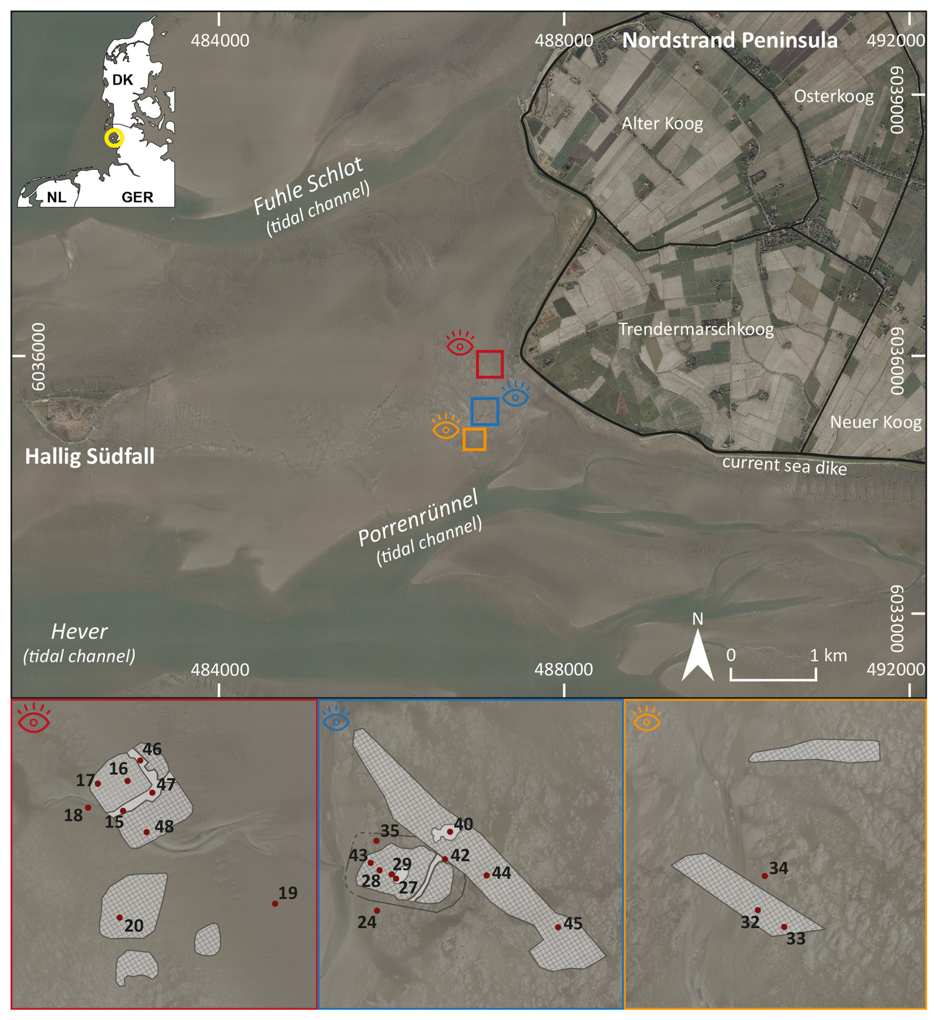
Figure 1Overview of the area between the Nordstrand Peninsula (North Frisia, Germany) and Hallig Südfall. Our study areas lie in front of the current sea dike of the modern Trendermarschkoog in the tidal flats of the Wadden Sea. The modern sea dike and summer dikes are depicted in black (digital orthophotos DOP20 LVermGeo SH 2014). Detailed views of the survey areas (red, blue and orange boxes) show the locations of coring related to the magnetic gradiometric prospection (shaded background) in the study area. Core numbers refer to internal labelling system (e.g. TRE 20A is denoted by 20).
Located on the North Frisian coast of Schleswig-Holstein, the Nordstrand Peninsula protrudes into the UNESCO World Heritage Site of the Wadden Sea and is only connected to the mainland by a carriageway. Nordstrand is divided into separate polders. Here, the polders facing the mainland are the most recent modern embanked marshlands. The Trendermarschkoog is located in the western part of the peninsula and adjoins, separated by a sea dike, the Wadden Sea. At low tide, the tidal flats between the Nordstrand Peninsula and Hallig Südfall are accessible.
To better understand the processes that formed the present-day coastline of North Frisia and to reconstruct its distinctive (cultural) landscape development, Hadler et al. (2022) found the so-called Trendermarsch on the Nordstrand Peninsula to be a suitable geoarchive to evaluate natural development and human interventions. Archaeological excavations in the embanked marshes of southern North Frisia (e.g. Nordstrand, Pellworm) had already revealed 12th-century-CE settlement remains like artificial dwelling mounds (so-called “terps”) and dikes, proving land reclamation and cultivation in the High Middle Ages (Müller-Wille, 1982; Kühn, 1984; Hoffmann, 1992).
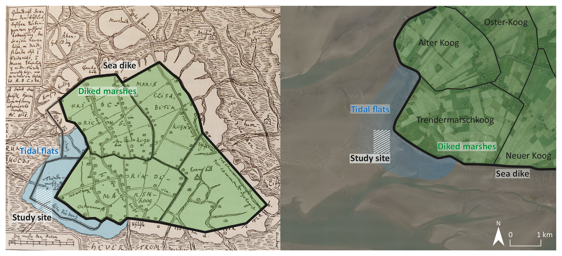
Figure 2The old map on the left shows an embankment plan designed by Christian de Cort in 1668 CE presenting the reinstallation of dikes demanded after the storm flood in 1634 CE (Müller and Fischer, 1936b). Both the original polder and the planned dike line, which largely corresponds to the current design, are illustrated here. On the right is a digital orthophoto of today's Trendermarschkoog on the Nordstrand Peninsula (digital orthophotos DOP20 LVermGeo SH 2014). The current polders were re-named (“Alter Koog” was “Friedrichs-Koog”, “Neuer Koog” was “Neuer Oster Koog” and “Oster-Koog” was “Marien-Elisabeth-Koog”). Colourisation: tidal flat (blue); diked marshland (green); main sea dike (black); dikes, possibly lost during storm floods (grey); study site (white, shaded). The eastern part of the construction map (left) shows only the planned embankment of marshland and therefore has not been named.
However, archaeological finds from the past decades (e.g. Busch, 1960) not only are limited to the diked marshes, but also reveal abundant remains of a former cultivated landscape outside the current sea dike. To date, though, there have not been any systematic investigations of the drowned marshland presumably preserved in tidal flats off Nordstrand and the Trendermarschkoog.
Therefore, we concentrated our geophysical and geomorphological research on the areas outside the present-day sea dike approximately 400 to 800 m west to southwest of the current sea dike of the Nordstrand Peninsula.
Here, the medieval sea dike of the Trendermarsch meets the modern dike orthogonally in the western section (Müller and Fischer, 1936b). Based on the evaluation of historical documents and embankment plans (Fig. 2), an altered medieval dike course can be expected. According to this, we assume there is a former cultivated marshland outside the current sea dike in the tidal flats.
The Saale (MIS 6–8, moraines) and Weichsel (MIS 2–4, glaciofluvial deposits) glaciation as well as the Eemian interglacial (MIS 5e, marine deposits) (STD, 2016) provided the Pleistocene base for today's Wadden Sea of North Frisia. Meltwater rivers formed the Pleistocene relief (Hoffmann, 2004) and still define today's topography. Today's tidal channels still correlate with Pleistocene depressions (Hoffmann, 2004). During the post-glacial transgressions of the North Sea, these depressions were filled up with fine-grained, clay-rich sediments, 10 to 15 m thick (Dittmer, 1952; Hoffmann, 1984; Ricklefs, 2016; Hadler et al., 2021). Repeated flooding of shallow zones with increasing marine influence induced the formation of marshland above the mean high-water level (MHW) (Bantelmann, 1960). During the 1st millennium BCE, initial fenland formation also took place in near-coast areas (Hoffmann, 1984, 2004; Hadler et al., 2022). At that time, sand spits of Pleistocene sediment in the west likely formed barrier islands that protected the Wadden Sea (Dittmer, 1952; Hoffmann, 2004). In the east, bogs were fed by groundwater from the higher Pleistocene regions (so-called “geest”) (Dittmer, 1952). It is assumed that the land surface during the phase of peat formation most likely was at a similar height, since peat formation started around 800 BCE across the entire study area (Wiermann, 1962; Hoffmann, 1984, 2004; Hadler et al., 2021, 2022). Today, the remaining peat layers are found at different depths, implying compaction of clayey sediments and leading to a relief with varying elevations and geomorphological depressions starting in the 1st millennium CE (Hoffmann, 1982, 2004). Pollen analyses, as well as geological and geoarchaeological data, indicate that the North Sea returned in the second half of the 1st millennium CE, causing the flooding of fenlands and the local development of a marsh environment (Wiermann, 1962; Hoffmann, 2004; Hadler et al., 2022).
Differences in the local coastal geomorphology are likely also reflected by differences in the local settlement history (Kühn, 1992). Around the island of Pellworm, occupation dates back to the Roman Iron Age (Bantelmann and Fischer, 1966; Hoffmann, 1984; Kühn, 1984), while the colonisation of Nordstrand did not start before the (High) Middle Ages (period from 1050–1250 CE) (Müller-Wille, 1982; Kühn, 1984, 1992, 2007). During high to late medieval times, North Frisia experienced intensified human–environment interactions (Bantelmann, 1960; Hoffmann, 1982, 1992; Müller-Wille, 1982).
On Pellworm, settlements already occur in early medieval times, erected directly on the natural ground surface but increasingly affected by flooding (Hoffmann, 1982; Müller-Wille, 1982). On the Nordstrand Peninsula, settlements only start in the High Middle Ages. They were not only erected on top of terps and protected by dikes against flooding (Bantelmann, 1960; Hoffmann, 1982, 1992, 2004; Müller-Wille, 1982), but also built as flat settlements. The latter implies that the natural elevation of the land surface must have been locally sufficient to provide natural flooding protection (Kühn, 1984; Hoffmann, 1992). Large-scale cultivation on the island of Pellworm and in the Nordstrand region was at its maximum during the High Middle Ages (Kühn, 1984; Hoffmann, 2004).
Depictions of the medieval North Frisian coastal landscape based on historical writings (letters, official documents), parish records and historical maps (e.g. embankment plans) often date back to the early modern period (Müller and Fischer, 1936a; Higelke, 1982; Panten, 2000; Newig, 2016). However, the illustration of many small diked marsh areas, so-called “polders” or in German “Köge”, most likely represents reminiscences of the cultural landscape of the High Middle Ages (Petersen and Rohde, 1977; Higelke, 1982; Panten, 2000).
In addition to drainage of the marshes and thus the compaction and dewatering of clay-rich sediments (Wiermann, 1962; Hoffmann, 2004), settlers lowered the land surface by peat extraction to cultivate fossil marshland found underneath or for salt production (Müller and Fischer, 1936a; Bantelmann, 1939; Panten, 1995; Hadler et al., 2021; Majchczack et al., 2024). Until the 14th century CE, embanked areas presumably strongly expanded, and single polders were merged to larger areas of cultivated land. The 14th century in particular marks a turning point in North Frisia's coastal history, representing the climax of the human-made landscape before its destruction by medieval and early modern storm floods (Müller and Fischer, 1936a; Hadler et al., 2018).
Reliable records of human intervention only exist for the early modern period. Old maps of the study area in medieval times were drawn only in the 17th century (Müller and Fischer 1936a, b) and must, therefore, be considered with caution. However, all depictions of the medieval Trendermarsch show a round polder, delimited by a continuous ring-shaped sea dike (maps by Peter Sax (for 1637 CE); Jan Berentz, 1633; Johannes Mejer, 1652 (for 1649); and Quirinus Indervelden, 1659 – Müller and Fischer, 1936a, b). Although these records commonly associate the Trendermarsch with the medieval island of Alt-Nordstrand, historical church registers, documents and tax registers listed the Trendermarsch individually, pointing instead to an isolated geomorphological setting (Kühn, 1995; Panten, 1995). Hadler et al. (2022) confirmed the polder's eastern delimitation by a tidal channel system which existed until the early modern period. A connection to Alt-Nordstrand (presumably) did not exist before the 1539 CE construction of Gaikenbüller Neuen Koog (southern dike of Alter Koog, formerly Friedrichs-Koog; Fig. 2) (Panten, 1995).
During high medieval times, the human impact on the former natural landscape was far advanced, resulting in large-scale embankment of the marshland (Müller and Fischer, 1936a). Still, the Trendermarsch was affected by extreme events like the 1362 and 1634 CE storm floods (i.a. Müller and Fischer 1936a, b; Panten, 1984).
During the 1634 CE event, the Trendermarsch was partly flooded after the breaching of the sea dike (Quedens, 1984), especially in the western part of the polder. Following the 1634 CE flood, the failure to promptly restore and maintain the dike(s) led to progressive destruction and permanent loss of cultural land (Müller and Fischer, 1936a; Quedens, 1984). Although church registers prove that the Trendermarsch church was still in use after the 1634 CE event for several years, the western part of the polder was likely no longer inhabitable (Müller and Fischer, 1936a; Panten, 1984). It took nearly 30 years to re-embank the remaining Trendermarsch in 1663 CE, work carried out by Dutch experts (Müller and Fischer, 1936b; Quedens, 1984). The construction map by Christian de Cort (Fig. 2) (1668) provides plans of the embankment of three new polders in Nordstrand.
We combined geophysical, geoarchaeological, geomorphological and archaeological methods to investigate the natural and anthropogenic development of the tidal flats of the Wadden Sea off the modern Trendermarschkoog. The study site in the tidal flats only allowed a limited time frame for investigations due to tides and the long walking distance, enabling approximately 3 to 4 h of work time during low tide.
4.1 Magnetic gradiometry
Magnetic gradiometry has proven to be a very effective prospection method in the tidal flats (see Wilken et al., 2022) regarding natural structures as well as archaeological features. The method is based on interferences of the local magnetic field compared to the Earth's natural magnetic field by subsurface structures (Fassbinder, 2015).
We used a custom equipment design consisting of an Eastern Atlas six-channel data logger (LEA D2), six Foerster Fluxgate vertical gradiometers and a Stonex model S9i real-time kinematic (RTK) GPS. The devices were mounted on a lightweight cart developed for tidal flat areas. The horizontal spacing of probes is 0.5 m, data sampling frequency is 20 Hz and GPS data rate is 10 Hz.
The data are interpolated to a grid of 0.2 m × 0.2 m bin size (Wilken et al., 2022). Measurements were carried out over a total area of approx. 1.5 km2, aiming at the extensive mapping of unknown structures in the tidal flat areas. Because of the huge size of the study area, measurements were conducted along search lines with 20 m equidistance. When anomalies were detected, measurements were intensified in the respective area.
4.2 Coring
Altogether, 22 cores were drilled in the study area (for locations of the coring sites, see Fig. 1) using closed steel augers with plastic inliners of 5 cm diameter and an Atlas Copco Cobra PROi coring device. Drilling depths ranged from 2 m to 4 m b.s. (below surface). Plastic inliners were opened, photographed, described and sampled in the laboratory following the standards of Ad-hoc Arbeitsgruppe Boden (2005). The coordinates of the coring sites were measured by differential GPS (DGPS; type Topcon HiPer V).
4.3 Palaeoenvironmental parameter analyses
Grain size data were collected from 293 sediment samples by the sieving and pipette method after Köhn (1929), considering the modern standard DIN ISO 11277 (Blume et al., 2011).
Loss of ignition (LOI), used to determine the proportion of organic material and mineral constituents within a sediment sample (Heiri et al., 2001), was measured for 5 g of each sediment sample. Each sample was at first heated for 24 h at 105 °C, weighed after cooling and finally heated again for 5–6 h at 550 °C (Blume et al., 2011).
The magnetic susceptibility of sediment samples, which indicates the magnetisability of minerals (Dearing et al., 1996), was measured using a Bartington MS3 device and MS2K surface sensor with a signal area of 25.4 mm2 and a signal depth of up to 8 mm (Dearing, 1999; Bartington Instruments Ltd., 2021). Measurements were carried out at 1 cm intervals directly on the core surface.
X-ray fluorescence (XRF) measurements were carried out in 2 cm intervals using a Niton XL3t 900S GOLDD handheld instrument (Thermo Fisher Scientific), set to the “Soil” mode with a corresponding measurement time of 30.5 s. For this study, we selected different ratios from the element concentrations delivered by the XRF analyses. The titanium calcium () ratio represents variations between terrestrial and marine influence (Rothwell and Croudace, 2015). Furthermore, we use this ratio as a weathering index, as calcium is more easily soluble than titanium (Kabata-Pendias 2011). The zirconium rubidium () ratio serves as a suitable proxy for reconstructing the energetic flow conditions at the time of deposition (Rothwell and Croudace, 2015). Zr is assigned to a coarser grain size (Rothwell and Croudace, 2015), while Rb adsorbs to clay minerals (Kabata-Pendias, 2011; Rothwell and Croudace, 2015).
Iron (Fe) and sulfur (S) can be used as proxies for reducing conditions (Rothwell and Croudace, 2015). Moreover, S is suitable for representing anoxic conditions and is enriched in sediments with high organic content (Rothwell and Croudace, 2015). Fe correlates with clay-enriched sediments (Gadow, 1970) and is important for the formation of Fe-sulfides such as pyrite and greigite under anoxic conditions. This leads to darker colouration of sediments, especially in shallow water environments or tidal flats (Blume et al., 2011).
4.4 Microfaunal analyses
We determined the assemblage of foraminifera and ostracods in sediment samples from different cores. For this, 15 mL of sediment was wet-sieved and divided into three fractions (> 400 µm, 400–200 µm, 200–125 µm). Samples were sieved wet, and the absolute number of specimens was counted using a Nikon SMZ 745T stereomicroscope. In cases of very high numbers of individuals, samples were divided and evaluated according to the approach of Scott and Hermelin (1993). Foraminifera and ostracod assemblages were used to reconstruct the environmental conditions at the time of sedimentation. Evaluation and classification of individuals are based on taxonomic descriptions by Murray (1979, 2006), Hayward et al. (2021), and Horton and Edwards (2006) for foraminifera and by Athersuch et al. (1989), Meisch (2000), Fuhrmann (2012) and Frenzel (2019) for ostracods. The assignment to ecological conditions was accomplished considering information by Penney (1987), Scott et al. (2001) and Scheder et al. (2019).
The classification of botanical macro-remains was conducted after Schoch et al. (1988) and Cappers et al. (2006). Molluscs were analysed based on taxonomic descriptions by Willmann (1989).
4.5 Radiocarbon dating
For chronological classification, 22 samples of organic material and biogenic carbonate were used for 14C accelerator mass spectrometry (AMS) dating (Table 1). Dating was accomplished at the Curt-Engelhorn-Zentrum Archäometrie (CEZA, Mannheim). For calibration of radiocarbon ages, we used the Calib 8.2 software with the calibration curves IntCal20 (Reimer et al., 2020) and Marine20 (Heaton et al., 2020) with local reservoir correction factor of (Enters et al., 2021).
5.1 Magnetic gradiometry
Magnetic gradiometry (Fig. 3) reveals distinct rectangular and linear anomalies of different sizes and amplitudes. Here, we focus on three areas of interest (Fig. 3, sections 1, 2 and 3), distributed over the investigated area.
Section 1 is located in the northern part of the study area and shows a cluster of three rectangular structures of ca. 50 m width and 61 m length in total (Fig. 4, section 1, anomalies I and II). The cluster is interrupted by an L-shaped formation (approx. 5 m wide, Fig. 4. anomaly IIIa) of low amplitude. About 25 m further south, we identified two smaller rectangular structures (Figs. 3, 4, anomaly I) whose shapes clearly have blurred edges.
Section 2 shows various anomalies of different amplitudes and shapes. Here, as well, we identified a large rectangular structure, separated into two smaller parts (Fig. 4, section 2, anomaly I – approx. 53 m wide and 39 m long – and anomaly II – approx. 15 m wide and 41 m long). In a central position, an elliptical anomaly with negative values is apparent (Fig. 4, section 2, anomaly I). Adjacent to the northern anomalies I and II (Fig. 4, section 2), an elongated structure of ca. 35 m width and at least 130 m length appears (Fig. 4, anomaly V). Further small unspecified anomalies are visible along this anomaly (e.g. Fig. 4, anomaly VI).
The elongated forms are characterised by a low to negative magnetic signal, present in sections 1 and 2 (Fig. 4). Filling materials are known to cause lower magnetic signals (e.g. Fassbinder, 2015). Accordingly, excavation and refilling of the same material afterwards produce a negative anomaly of the magnetic gradiometry. As a result, these areas are clearly demarcated from the surrounding sediment.
In the southernmost section of the study area, section 3 (Fig. 4, section 3), we detected a wide elongated structure (approx. 17–20 m wide, Fig. 4, section 3, anomaly IV). Even though this structure's signal becomes weaker to the east and west in the search grid, it obviously continues in both directions.
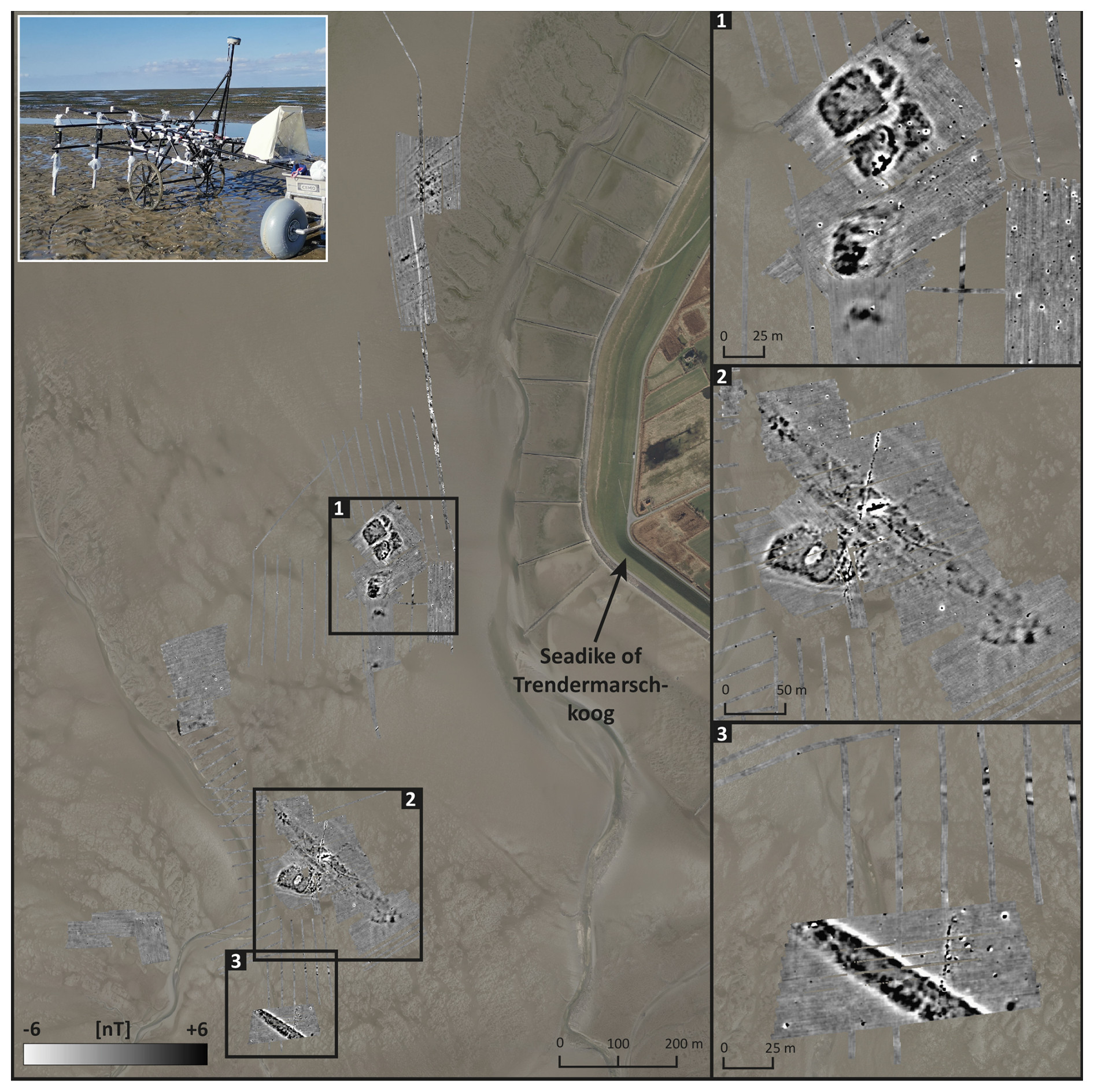
Figure 3Results of the magnetic gradiometric survey in the study area. The amplitude range reaches from −6 nT (white) to +6 nT (black). Measurements were carried out between 2021 and 2023 (base map: DOP20 LVermGeo SH 2014). Inlay photo to the upper left: photo of measurement equipment.
5.2 Sedimentary facies and stratigraphic units
Sediment cores were drilled at specific sites (Fig. 3, sections 1–3) with a focus on distinct magnetic gradiometry anomalies. Based on sedimentary, geochemical and microfaunal analyses, we identified 13 stratigraphic (sub-)units (see Table 2 with results of the palaeoenvironmental parameter analyses).
The following stratigraphic units were found at several sites in the study area.
Unit A
Sediments are dominated by silt, appear homogenous and are dark grey to grey. The unit marks the lowermost layer and is present in most cores. Very low values indicate low flow dynamics and a quiescent depositional environment. Marine influence is indicated by the dominance of calcareous species of foraminifera, such as Haynesina germanica, Ammonia beccarii or Cribroelphidium williamsoni, and the occurrence of saltwater-indicative ostracods (Table 2). Unit A is present in almost all cores in the study area.
Unit B
Silt is the predominant grain size of unit B, with sediments showing a distinctive marbled grey to light-grey appearance. The composition of microfauna is similar to that of unit A, with dominating calcareous species indicative for marine shallow water zones (Table 2). This unit always follows the sediments of unit A but was not found in all cores.
Unit C
Unit C comprises different sub-units, all of which are characterised by fine-grained sediment and comparable similar geochemical parameters. Here, agglutinated species of foraminifera are predominantly present.
Sub-unit C.1 is also characterised by fine-grained, silt-dominated sediment. Locally increased magnetic susceptibility (MS) points to initial weathering processes. Sub-unit C.2 differs from sub-unit C.1 by a higher amount of fine-grained sediment and the increased proportion of agglutinated foraminifers typical of the higher salt marsh. Furthermore, sediment of C.2 is distinguished by a higher content of organic material (roots of reed), represented by higher LOI values. In most cores, there is a smooth transition from sub-unit C.1 to sub-unit C.2 (occurs in cores TRE 16A, TRE 17A, TRE 20A, TRE 28A, TRE 29A, TRE 32A, TRE 33A, TRE 43A, TRE 48A).
In a few cores (TRE 16A, TRE 20A, TRE 33A), we identified a bluish-grey silt-dominated sediment with a solid soil texture. This sub-unit C.3 shows close similarities to sub-unit C.2 but lower MS values, indicating less intensive weathering. We found sub-unit C.3 only on top of unit D.
Unit D
This unit presents the highest LOI values and mostly consists of reed, showing different stages of decomposition. Foraminifera and ostracods are absent. This layer is often preserved in cores, located in central areas of the magnetic anomalies (TRE 16A, TRE 17A, TRE 20A, TRE 29A, TRE 32A, TRE 33A, TRE 48A) and follows sediments of unit C.2.
Unit G
Sediments consist of fine and medium sand. They mark the top layer at each coring site in the study area. The unit's thickness varies between 1–3 m. Low values of the ratio and high values of the ratio indicate a high marine influence with increased flow dynamics. The microfaunal composition is dominated by calcareous species typical of marine environments (Table 2). Unit G occurs area-wide and represents the overlying sediment at the study site.
Across the study area, some sedimentary units were only encountered at single core locations. For classification, we partly considered the results of the magnetic gradiometry.
Unit I
Unit I is characterised by a very high amount of marine shell fragments (mostly Cerastoderma edule) and high microfaunal diversity (Table 2).
In this layer, the ratio shows very high values, suggesting sedimentation under high flow dynamics. This sedimentary and microfaunal composition can only be confirmed for core TRE 27A.
Unit E
Sub-unit E.1 is characterised by conspicuous dark-grey to bluish clay and silt with medium to high LOI values. The occurrence and high abundance of the ostracod Sarscypridopsis aculeata, characteristic of fresh or brackish water conditions, are striking. The appearance of sediments of unit E.1 is limited to cores of the northern magnetic anomaly (Fig. 3, section 1; TRE 15A, TRE 46A). In most cases, sub-unit E.1 is followed by unsorted obviously reworked sediment (sub-unit E.2) consisting of a mixture of silty to clayey marsh sediment, peat debris and sand. This unit appears heterogeneously, sometimes together with alternate colouration.
Unit F
Unit F comprises various sub-units that consolidate disturbed or re-arranged sediments.
Sub-unit F.1 was only found in core TRE 40A. The sediment consists of sandy silt, has a distinct red colour, and shows remarkably high values of MS that likely reflect equally high values of Fe (Table 2). The unit shows a high amount of charcoal, while foraminifera and ostracods are absent.
Silt-dominated sub-unit F.2 was only found in core TRE 44A. It appears similar to sub-unit C.3, but the concentrations of Fe and S are higher. Characteristic is the blended structure of sediment. Its foraminifera spectrum is similar to the one of sub-unit C.2, with a weak dominance of calcareous species and a low number of agglutinated species (Table 2). Ostracods are absent.
Sub-unit F.3 is also dominated by silt; it is also restricted to core TRE 44A. Its geochemical characteristics resemble those of unit B and sub-unit C.1. The occurrence of botanical macro-remains like Zannichellia palustris and a very high number of Characeae sp. is striking. Both are aquatic plants typical of freshwater-dominated slack waterbodies with minor flow dynamics.
Table 1Radiocarbon ages of samples from different vibracores recovered from the tidal flats near the modern Trendermarschkoog. The calibration is based on the Calib 8.2 software, using the calibration curves IntCal20 (Reimer et al., 2020) and Marine20 (Heaton et al., 2020) with a local reservoir correction factor of ΔR= C years (Enters et al., 2021). Remarks: a.s.l., above mean sea level; Lab. no., laboratory number; MAMS, accelerator mass spectrometry (AMS), Curt-Engelhorn-Zentrum Archäometrie, Mannheim; 1σ max; min (cal BCE/CE), calibrated ages, 1σ range; 2σ max; min (cal BCE/CE), calibrated ages, 2σ range; “;”, as there are several points of intersection with the calibration curve, there are several possible age intervals.
Table 2Stratigraphic units encountered in sediment cores from the Trendermarsch area and the derived facies based on their sedimentological, geochemical and microfaunal characteristics. Selected core photos, grain size data and LOI are representative of the sedimentary facies. Measurements of magnetic susceptibility, element concentrations and ratios are given as median values for the respective unit. Relative classification in terms of very low, low, medium, high and very high is based on maximum and minimum value ranges. Microfaunal composition is given as average values. Abundance is given as absolute values.

6.1 Natural landscape development
The widespread occurrence of basal unit A provides evidence that the entire area was under the influence of marine shallow water conditions with low-energy flow dynamics, comparable to lagoonal conditions (Figs. 5 and 6). Our results are consistent with previous reports on unit-A-type sediments, up to 13 m thick, found on top of Pleistocene deposits (LfU SH with different corings from 1968, 1978 and 1979; Hadler et al., 2021, 2022). Unit A suggests long-term stable conditions that fit well with the presumed position of the Wadden Sea area sheltered by Pleistocene barriers and a Holocene sand spit towards the west (Dittmer, 1952; Hoffmann, 1984, 2004).
Lagoon-like shallow water conditions in the study area are followed by the development of a pioneer zone (unit B) and the subsequent formation of a lower to high salt marsh (sub-units C.1 and C.2) by advancing accumulation of sediment above mean high water (MHW) until the early 1st millennium BCE at the latest (Wiermann, 1962; Hadler et al., 2022). Starting around ca. 800 BCE (805–773 cal BCE, TRE 16A/11+ PR; 891; 797 cal BCE, TRE 33A/7+ PR2; 773–741 cal BCE, TRE 48A/8+ PR2; Table 1), coastal fenland was formed (unit D), lasting at least until ca. 350 to 100 BCE (351; 105 cal BCE, TRE 16A/8+ PR; 346; 104 cal BCE, TRE 33A/7+ PR1; Table 1). In the landward Trendermarsch, fenland formation continued at least until ca. 200 to 300 CE (Hadler et al., 2022). Our findings of semi-terrestrial freshwater conditions in the Trendermarsch are in line with those of Wiermann (1962) and Hoffmann (2004), who found strongly reduced marine influence for North Frisia during the 1st millennium BCE.
The returning North Sea and the associated flooding of fenlands lead to the renewed formation of marshland in the study area (sub-unit C.3), starting presumably after 200 CE (Fig. 7; Hadler et al., 2022). The reactivation of marsh sedimentation in North Frisia was also described by Hoffmann (1984, 2004) for the early 1st millennium CE. In the Trendermarsch area, marshland formation (so-called “Nordstrander Klei”; Dittmer, 1952) takes place at least until ca. 600 CE (TRE 16A/7 PR, 556–651 cal CE; Table 1). Landscape development is then marked by a distinct hiatus, as younger tidal flat deposits (unit G) directly overlie 1st millennium CE marsh and older units.
Figure 4Interpretation of the results of magnetic gradiometry measurements and sediment cores in the study area (digital orthophotos DOP20: LVermGeo SH 2014). (1) Illustration of terp construction (I, red) and its extension (II, blue), divided by an L-shaped ditch (IIIa, light blue). (2) Imprint of primary terp base (I, red) and the terp enlargement (II, blue). The enclosure ditch (IIIb, light blue) is clearly visible south of the structures and weakly discernible towards the east. The distinctive shape of a peat extraction area (V, orange) is at a tangent to the settlement outline in the north. (3) Considering old maps and already-known dike imprints (Wilken et al., 2022), the wide linear structure is interpreted as the dike body (IV, beige) continuing towards the northwest and southeast. The anthropogenic impact in modern times is present in the form of presumed pipelines or conduction lines (black line).
6.2 Human–environment interactions: the Trendermarsch before and after 1362 CE
Results of magnetic gradiometry measurements (Figs. 3 and 4) reveal several structures in the present-day tidal flats off the modern sea dike of Nordstrand. Based on comparable phenomena described from North Frisia (Hoffmann, 1982; Rabbel et al., 2023; Wilken et al., 2022), the southern North Sea (Siegmüller, 2020) and the Netherlands (Bazelmans et al., 2012; Nieuwhof et al., 2019), we interpret the rectangular structures (Fig. 4, sections 1 and 2, anomaly I and II) as human-made terps. Analogously to observations made for the nearby Hallig Südfall area (Wilken et al., 2022), the linear structure of anomaly IV (Fig. 4, section 3) seems to represent the imprint of a former dike.
Based on archaeological evidence, the intense cultivation of marshland and systematic construction of settlements in the Trendermarsch area can be dated to the High Middle Ages (Müller-Wille, 1982; Kühn, 1984, 2007). Although some evidence suggests the initial erection of houses on the immediate ground level, high medieval settlers typically constructed artificial dwelling mounds to protect their homes against flooding (Müller-Wille, 1982). Older sediment layers are then often preserved below the base of these dwelling mounds and give insights into environmental conditions prior to cultivation (Nieuwhof et al., 2019). It is further assumed that in the Nordstrand area, medieval settlers cultivated bare fenlands or raised bogs for colonisation, while fenlands and raised bogs in the northern Halligen area were covered by a layer of younger marsh sediment (Bantelmann, 1960; Kühn, 1984). Our results show a thin layer of marsh sediment (cf. Sect. 6.1, sub-unit C.3; Figs. 5 and 6) covering the fenland (unit D). Similar results were found by Hadler et al. (2022) in the landward part of the medieval Trendermarsch polder, where it served as the settlement surface at the time of marshland occupation and thus represents the onset of human intervention in the study area. Remains of this (pre-)medieval fossil marsh in today's tidal flats are only preserved as “footprints” (e.g. Wilken et al., 2022) below human-made structures, caused by the overloading of dwelling mounds (Figs. 3 and 4, sections 1 and 2; Fig. 5, coring sites 16A and 20A) and dikes (Figs. 3 and 4, section 3; Fig. 6, coring site 33A). Still, we assume that in the drowned part of the medieval Trendermarsch, cultivation and occupation most likely also occurred on coastal marshland and not on fenland.
Although clearly depicted in the magnetic map (e.g. Figs. 3 and 4, sections 1 and 3), many core stratigraphies in the study area (Figs. 5 and 6) do not show any sedimentary evidence of the medieval Trendermarsch occupation at all. We found (post-)medieval deposits only preserved in artificial depressions like ditches (Fig. 5, coring sites 15A, 46A and 47A). Combining geoarchaeological and geophysical observations, in today's tidal flats there is only an imprint left of the former medieval settlements that once deformed the underlying stratigraphic units by their superimposed load (Wilken et al., 2022).
Our investigations show the tidal flat's potential as a geoarchive for palaeolandscape reconstruction although many other parts of the Wadden Sea have undergone strong erosion. Our results confirm the old map by C. de Cort (1668) (Fig. 2), who depicted the study area as a former part of the medieval Trendermarsch before its destruction in 1634 CE (Müller and Fischer, 1936a). Furthermore, we found a pattern of scattered settlements in the study area, very similar to the situation in the modern Trendermarschkoog (Hadler et al., 2022). These single homestead terps show close similarities in shape and structure with early to high medieval cultivation patterns of the southern North Sea region and the Netherlands (Nitz, 1984; Bazelman et al., 2012; Nieuwhof et al., 2019), typical of the cultivation of higher marshland. Settlement remains around Hallig Südfall document, on the contrary, cultivation and occupation of lower marshes of fenlands and raised bogs (Busch, 1954, 1962, 1971).
Figure 5Stratigraphic overview of the northern part of the Trendermarsch (Fig. 3, section 1). Magnetic gradiometry map to the lower right shows location of coring sites. Ages in italics are considered reworked. Validated ages are printed in bold.
For the drowned part of the Trendermarsch, it is conceivable that in the Middle Ages the area had a “Halligen”-like character with a higher ground level compared to the surroundings. Hadler et al. (2022) have already presumed a higher topography of the former marshland based on the presence of younger fossil marsh deposits. We, therefore, postulate that medieval cultivation in the Nordstrand region likely started in the Trendermarsch and moved westwards.
At two sites, we observed distinct ditches that intersect the terp's outline (Sect. 4.1; Figs. 3 and 4, sections 1 and 2; Fig. 5, coring sites TRE 15A, TRE 46A and TRE 47A). Organic mud (sub-unit E.1) and filling (sub-unit E.2) of the ditches date from ca. 800 BCE (799–770 cal BCE, TRE 46A/10 PR; Table 1) to the 15th century CE (1407–1434 cal CE, TRE 47A/2 PR; Fig. 5, Table 1) and imply intense reworking and obviously the ditches' artificial backfill. Deposits of sub-unit E.1 were dated to the late 12th to the early 13th century CE (1167; 1260 cal CE, TRE 46A/14 PR2; Table 1), dating the active ditch around a small terp in the high medieval period. This fits well with findings from the Netherlands, where artificial dwelling mounds have often been found surrounded by ditches (Nieuwhof et al., 2019). Based on sub-unit E.2, we assume a dwelling mound expansion as the ditch contains material that is otherwise typical of the surrounding surface. Dating implies that the filling and the potential terp expansion occurred around the early 15th century CE (1407–1434 cal CE, TRE 47A/2 PR; Table 1). For this period, historical documents and archaeological and geomorphological evidence have already indicated the massive destruction of cultivated marshland caused by the first Grote Mandränke storm flood in 1362 CE (Müller and Fischer, 1936a; Hadler et al., 2018; Wilken et al., 2022). However, from our results, we assume not only the survival but also the ongoing cultivation of the Trendermarsch area after the 1362 CE storm flood. That said, it seems as if the first Grote Mandränke made it necessary to extend and elevate the terps in the first place and thereby fill the ditches for expansions (Fig. 4, sections 1 and 2). It is further very likely that the Halligen-like character and the higher ground level of the medieval marshland of the Trendermarsch provided more protection, so the Trendermarsch was not left permanently drowned by the first Grote Mandränke in 1362 CE. On the contrary, missing peat layers above the settled surface to the west of Hallig Südfall suggest the cultivation of marshland including peat excavation and lowering of the ground surface that favoured its drowning in 1362 CE (Hadler et al., 2018, 2021).
Southwest of the prospected terps, the dike remains' stratigraphy (Fig. 4, section 3, anomaly IV) shows a marsh layer (sub-unit C.3) on top of peat. Dating to the 1st to 3rd century CE (132; 318 cal CE, TRE 33A/7 PR2; Table 1), this layer did not belong to the dike body itself, but rather it represents the compressed basal sediments. Considering old maps (see Fig. 2; Hadler et al., 2022), this dike was once part of the former Trendermarsch dike system. We were, for the first time, able to validate a part of the western delimitation of the medieval Trendermarsch polder that had, previously, only been attested by historical sources. Moreover, it was also possible to delineate the southwestern extent of the medieval Trendermarsch.
Hadler et al. (2022) found a tidal channel at the eastern margin of the medieval Trendermarsch, which supports the idea of a round polder as illustrated by historical documents (Müller and Fischer, 1936a; Panten, 1995). Associated ring-shaped dike systems are well known from Friesland and the Netherlands and are typical of the early colonisation of the 12th to 13th centuries CE (Bazelmans et al., 2012).
Figure 6Stratigraphic overview of the southern part of the Trendermarsch (Fig. 3, sections 2 and 3). Magnetic gradiometry map to the lower right shows locations of vibracoring sites. Ages in italics are considered reworked. Validated ages are printed in bold.
Figure 7Timeline of relevant development phases in the Trendermarsch based on the palaeogeographical reconstruction. For the landward Trendermarsch, see Hadler et al. (2022).
6.3 A changing landscape: the Trendermarsch after the storm flood of 1634 CE
From historical reports and our results, cultivation of the Trendermarsch took place in at least two phases. We identified cultivation patterns before and also after 1362 CE (Fig. 3, section 2), when the first Grote Mandränke occurred (Fig. 7).
As stated above (see Sect. 3), land losses of the 1634 CE storm flood also affected the Trendermarsch (Müller and Fischer, 1936a), where parts of the dike system were finally able to be restored by 1663 CE (Müller and Fischer, 1936a, b; Quedens, 1984), while the western part of the polder had to be given up and turned into tidal flats. Still, we find evidence of human impact in this drowned landscape.
Although we did not find any evidence of large-scale (medieval) peat extraction in the study area (cf. Bantelmann and Fischer, 1966), red-coloured brick-like deposits (sub-unit F.1, Table 2) document some sort of (local) peat processing. Such brick-like ashes are the typical residues of salt production from peat as they are already known in their typical composition and properties from surrounding areas (Bantelmann, 1939; Prange, 1962) and often disposed of in adjacent ditches or pits (Bantelmann and Fischer, 1966). We found such first sedimentary evidence of salt production in the Trendermarsch area preserved in a pit-like structure (Fig. 4, section 2, anomaly VI; Fig. 6). A fragment of shell embedded in the uppermost part of the peat combustion residues allowed the disposal to be dated to the (early) modern period (1546–1874 cal CE, TRE 40A/7 M; Table 1) and thus after the 1634 CE storm event. So far, historical records on (small-scale) peat extraction in the Trendermarsch area have only been known for the 15th century CE (Müller and Fischer, 1936a; Panten, 1995). Regarding the post-1634 CE peat extraction, we assume that this small-scale peat extraction for salt production was likely restricted to natural peat outcrops in areas accessible after 1634 CE (Kühn, 2007) and exposed by tides and erosion of the overlying, drowned marshland. Traces of (early) modern human impact in the drowned Trendermarsch are also confirmed for a nearby ditch structure, filled in between the late 14th and mid-17th centuries CE (1469–1750 cal CE, TRE 42A/8+ M; Table 1) and likely also related to peat extraction. To sum up, not only does the post-medieval phase of settlement and land use in the Trendermarsch give evidence for the enlargement of terps after 1362 CE (Fig. 4, sections 1 and 2; cf. Sect. 6.2), but also we even found evidence of human interventions and use of local resources by peat processing (sub-unit F.1; Fig. 4, section 2; Fig. 6, core TRE 40A) in the already-drowned landscape after the second Grote Mandränke in 1634 CE.
The map by C. de Cort (Fig. 2) shows that the western part of the Trendermarsch was finally systematically diked out after 1634 CE (Müller and Fischer, 1936b; Bantelmann, 1960; Panten, 1984). In this way, the modern system of dikes and marshland polders was initiated.
Using an interdisciplinary methodological approach based on geophysical, geoarchaeological and geomorphological investigations combined with the evaluation of historical documents, we reconstructed the coastal evolution and human–environment interactions in the medieval Trendermarsch area, located today in the tidal flats of the North Frisian Wadden Sea. The main conclusions of our study area as follows:
-
The local stratigraphy and dating provide distinct evidence of land reclamation measures and cultivation in the drowned part of the Trendermarsch, beginning as early as the 12th to the early 13th centuries CE (1167; 1260 cal CE).
-
Combining magnetic prospection and sedimentary records, our results show that the first settlements in the Trendermarsch were erected on terps in a salt marsh environment and not, as often discussed for adjacent areas, in a fenland following peat extraction.
-
We identified a phase of enlargement of artificial dwelling mounds most probably necessary after the storm flood in 1362 CE. The stratigraphy of ditch infill with allochthonous material can be classified into a time frame after the storm flood in 1362 CE. With this, we – for the first time – document the local human response to the impact of the 1362 CE storm flood, which had been completely missing from the historical record.
-
Brick-like ashes found in ditches (Fig. 6, TRE 40A) and dating to 1546–1874 cal CE further attest to peat processing during the modern period.
-
Evidence of (early) modern peat extraction after the Trendermarsch's partial drowning in 1634 CE shows that even after land losses by this devastating event, human impact on the coastal landscape continued on a much smaller scale.
-
Our results confirm the historical cartographic depiction, suggesting that the Trendermarsch was once embanked with a ring-shaped dike and that its western part was abandoned after the storm surge in 1634 CE.
-
Actual archaeological finds from the medieval cultivation period are missing at the site due to ongoing erosion. However, by tracing their “footprints”, we were able to revive and reconstruct at least parts of the drowned landscape.
-
In summary, we can confirm historical records and trace the century-long struggle of Frisians in the Trendermarsch, especially associated with the 1362 and 1634 CE flooding events.
-
Altogether, the state of preservation of the younger fossil marsh (unit C.3) and the elevated ground surface level of the Trendermarsch support our hypothesis that the physiographic conditions of the Trendermarsch were causally responsible for the marshland withstanding storm flood events.
-
Our study finally highlights the unique preservation conditions and potential of the tidal flat geoarchive for reconstructing drowned landscapes and human–environment interactions in the North Frisian Wadden Sea and calls for large-scale future research in the tidal flat.
The data presented here are available on request from the corresponding author due to cultural heritage reasons.
Conceptualisation: HH, DW, AR. Data curation: AR, HH, DW. Formal analysis: DW, SB. Funding acquisition: HH, DW, RB, UI, WR, AV. Investigation: AR, HH, TW, DW, BSM, SB, RB, SK. Methodology: HH, DW, AR. Project administration: HH, AV, DW, RB, UI. Resources and software: AV, HH, WR, DW. Supervision: HH. Visualisation: AR, HH. Writing – original draft preparation: AR. Writing – review and editing: AR, HH, DW, AV, BSM.
The contact author has declared that none of the authors has any competing interests.
Publisher's note: Copernicus Publications remains neutral with regard to jurisdictional claims made in the text, published maps, institutional affiliations, or any other geographical representation in this paper. While Copernicus Publications makes every effort to include appropriate place names, the final responsibility lies with the authors.
This article is part of the special issue “Quaternary research in times of change – inspired by INQUA Roma 2023”. It is a result of the INQUA conference, Rome, Italy, 14–20 July 2023.
Work permits were kindly issued by the Schleswig-Holstein State Office for Coastal Protection, National Park and Marine Protection (Landesbetrieb für Küstenschutz, Nationalpark und Meeresschutz Schleswig-Holstein) and the State Archaeology Department of Schleswig-Holstein (Archäologisches Landesamt Schleswig-Holstein). The authors would like to thank Elena Appel and Tina Georg for their support during field campaigns.
This study was carried out in the framework of the Rungholt project funded by the German Research Foundation (grant nos. HA 7647/1-1, HA 7647/3-1, VO 938/21-1 and VO 938/31-1, project no. 442822276) and the ROOTS Cluster of Excellence (EXC 2150-390870439).This open-access publication was funded by Johannes Gutenberg University Mainz.
This paper was edited by Julia Meister and reviewed by two anonymous referees.
Ad-hoc-Arbeitsgruppe Boden der Staatlichen Geologischen Dienste und der Bundesanstalt für Geowissenschaften und Rohstoffe (Ed.): Bodenkundliche Kartieranleitung: Mit 41 Abbildungen, 103 Tabellen und 31 Listen, 5., verbesserte und erweiterte Auflage, Schweizerbart'sche Verlagsbuchhandlung (Nägele und Obermiller), Stuttgart, 438 pp., ISBN 978-3-510-95920-4, 2005.
Athersuch, J., Horne, D. J., and Whittaker, J. E.: Marine and brackish water ostracods: (superfamilies Cypridacea and Cytheracea); keys and notes for the identification of the species, Brill, Leiden, 359 pp., ISBN 90-04-09079-7, 1989.
Auge, O.: Die nordfriesischen Uthlande und König Waldemar II. der Sieger (Sejr) von Dänemark., in: Rungholt. Rätselhaft & widersprüchlich, edited by: Newig, J. and Haupenthal, U., Husum Druck- und Verlagsgesellschaft, Husum, 37–40 pp., ISBN 978-3-89876-824-5, 2016.
Bantelmann, A.: Das nordfriesische Wattenmeer. Eine Kulturlandschaft der Vergangenheit, Westküste, 39–115, https://hdl.handle.net/20.500.11970/100537 (last access: 21 February 2024), 1939.
Bantelmann, A.: Forschungsergebnisse der Marschenarchäologie zur Frage der Niveauveränderungen an der schleswig-holsteinischen Westküste, Die Küste – Archiv für Forschung und Technik an der Nord- und Ostsee, 8, 45–65, https://hdl.handle.net/20.500.11970/100725 (last access: 22 February 2024), 1960.
Bantelmann, A. and Fischer, F.: Die Landschaftsentwicklung an der schleswig-holsteinischen Westküste, dargestellt am Beispiel Nordfriesland. Eine Funktionschronik durch fünf Jahrtausende., in: Die Küste 14/2, Vol. 14, edited by: Der Küstenausschuss Nord- und Ostsee, Heide, Holstein, 5–99, https://hdl.handle.net/20.500.11970/100928 (last access: 22 February 2024), 1966.
Bartington Instruments Ltd (Ed.): MS2/MS3 – Magnetic Susceptibility Measuring Equipment, Technical report, Witney, Oxford, UK, 22 pp., https://www.bartington.com/products/magnetic-susceptibility/ms2-ms3-system/ (last access: 2 September 2024), 2021.
Bazelmans, J., Meier, D., Nieuwhof, A., Spek, T., and Vos, P.: Understanding the cultural historical value of the Wadden Sea region. The co-evolution of environment and society in the Wadden Sea area in the Holocene up until early modern times (11,700 BC–1800 AD): An outline, Ocean Coast. Manage., 68, 114–126, https://doi.org/10.1016/j.ocecoaman.2012.05.014, 2012.
Blume, H.-P., Stahr, K., and Leinweber, P. (Eds.): Bodenkundliches Praktikum: Eine Einführung in pedologisches Arbeiten für Ökologen, insbesondere Land- und Forstwirte, und für Geowissenschaftler, 3., neubearbeitete Auflage, Spektrum Akademischer Verlag, Heidelberg, 255 pp., ISBN 978-3-8274-1553-0, 2011.
Busch, A.: Flurnamen und Fluruntersuchungen in der Gemarkung Hallig Südfall, in: Nordelbingen, Vol. 22, Westholsteinische Verl.-Anst. Boyens, Heide, Holstein, 108–115, 1954.
Busch, A.: Eine alte Landoberfläche und Kulturspuren im Nordstrander Watt, Die Küste – Archiv für Forschung und Technik an der Nord- und Ostsee, 8, 124–130, https://hdl.handle.net/20.500.11970/100738 (last access: 21 February 2024), 1960.
Busch, A.: Die heutige Hallig Südfall und die letzten Spuren Rungholts und über Clades Rungholtina., Karl Wachholtz Verlag, Neumünster, 1962.
Busch, A.: 50 Jahre Rungholtforschung, Vol. 6, Karl Wachholtz Verlag, Neumünster, 153–160, https://resolver.sub.uni-hamburg.de/kitodo/PPN8460602210078 (last access: 22 February 2024), 1971.
Cappers, R. T. J., Bekker, R. M., and Jans, J. E. A. (Eds.): Digitale Zadenatlas van Nederland: = Digital seed atlas of the Netherlands, Barkhuis [u.a.], Groningen, 502 pp., ISBN 978-90-77922-11-8, 2006.
CWSS (Common Wadden Sea Secretariat): Introduction, in: Wadden Sea Quality Status Report, Wilhelmshaven, Germany, https://qsr.waddensea-worldheritage.org/reports/introduction (last access: 14 January 2024), 2017.
Dearing, J.: Environmental Magnetic Susceptibility: Using the Bartington M2S System, edited by: Bartington Instruments, 43 pp., ISBN 0952340909, 1999.
Dearing, J., Hay, K. L., Baban, S. M. J., Huddleston, A. S., Wellington, E. M. H., and Loveland, P. J.: Magnetic susceptibility of soil: an evolution of conflicting theories using a national data set, Geophys. J. Int., 127, 728–734, https://doi.org/10.1111/j.1365-246X.1996.tb04051.x, 1996.
Dittmer, E.: Die nacheiszeitliche Entwicklung der schleswig-holsteinischen Westküste, Meyniana 1, 138–168, 1952.
Enters, D., Haynert, K., Wehrmann, A., Freund, H., and Schlütz, F.: A new ΔR value for the southern North Sea and its application in coastal research, Neth. J. Geosci., 100, e1, https://doi.org/10.1017/njg.2020.19, 2021.
Fassbinder, J. W. E.: Seeing beneath the farmland, steppe and desert soil: magnetic prospecting and soil magnetism, J. Archaeol. Sci., 56, 85–95, https://doi.org/10.1016/j.jas.2015.02.023, 2015.
Frenzel, P.: Fossils of the southern Baltic Sea as palaeoenvironmental indicators in multi-proxy studies, Quaternary Int., 511, 6–21, https://doi.org/10.1016/j.quaint.2018.09.014, 2019.
Fuhrmann, R.: Atlas quartärer und rezenter Ostrakoden Mitteldeutschlands, Naturkundliches Museum Mauritanium, Altenburg, 330 pp., ISSN 0232-5381, 2012.
Gadow, S.: Sedimente und Chemismus, in: Das Watt, edited by: Reineck, H.-E., Verlag von Waldemar Kramer, Frankfurt am Main, 23–35, ISBN 9783782910675, 1970.
Hadler, H., Vött, A., Newig, J., Emde, K., Finkler, C., Fischer, P., and Willershäuser, T.: Geoarchaeological evidence of marshland destruction in the area of Rungholt, present-day Wadden Sea around Hallig Südfall (North Frisia, Germany), by the Grote Mandrenke in 1362 AD, Quaternary Int., 473, 37–54, https://doi.org/10.1016/j.quaint.2017.09.013, 2018.
Hadler, H., Vött, A., Willershäuser, T., Wilken, D., Blankenfeldt, R., Carnap–Bornheim, C., Emde, K., Fischer, P., Ickerodt, U., Klooß, S., Majchczack, B., Obrocki, L., and Rabbel, W.: Automated facies identification by Direct Push–based sensing methods (CPT, HPT) and multivariate linear discriminant analysis to decipher geomorphological changes and storm surge impact on a medieval coastal landscape, Earth Surf. Process. Landf., 46, 3228–3251, https://doi.org/10.1002/esp.5232, 2021.
Hadler, H., Wilken, D., Bäumler, S., Fischer, P., Rabbel, W., Willershäuser, T., Wunderlich, T., and Vött, A.: The Trendermarsch polder (North Frisia, Germany) – Geophysical and geoarchaeological investigations of an anthropogenic medieval coastal landscape and its vulnerability against natural hazards, Geomorphology, 418, 108461, https://doi.org/10.1016/j.geomorph.2022.108461, 2022.
Hartmann, P.: Keramik des Mittelalters und der frühen Neuzeit aus Nordfriesland, Karl Wachholtz Verlag, Neumünster, 60 pp., ISBN 978-3-529-01132-0, 1975.
Hayward, B. W., Holzmann, M., Pawlowski, J., Parker, J. H., Kaushik, T., Toyofuku, M. S., and Tsuchiya, M.: Molecular and morphological taxonomy of living Ammonia and related taxa (Foraminifera) and their biogeography, Micropaleontology, 67, 109–313, https://www.jstor.org/stable/27143662 (last access: 27 March 2024), 2021.
Heaton, T. J., Köhler, P., Butzin, M., Bard, E., Reimer, R. W., Austin, W. E. N., Bronk Ramsey, C., Grootes, P. M., Hughen, K. A., Kromer, B., Reimer, P. J., Adkins, J., Burke, A., Cook, M. S., Olsen, J., and Skinner, L. C.: Marine20 – The Marine Radiocarbon Age Calibration Curve (0–55 000 cal BP), Radiocarbon, 62, 779–820, https://doi.org/10.1017/RDC.2020.68, 2020.
Heiri, O., Lotter, A., and Lemcke, G.: Loss on ignition as a method for estimating organic and carbonate content in sediments: reproducibility and comparability of results, J. Paleolimnol., 25, 101–110, https://doi.org/10.1023/A:1008119611481, 2001.
Higelke, B.: Das Norderhever-Projekt. Beiträge zur Landschafts- und Siedlungsgeschichte der nordfriesischen Marschen und Watten. Besiedlungs- und jüngere Landschaftsgeschichte. Geographische Untersuchungen, in: Offa – Berichte und Mitteilungen zur Urgeschichte, Frühgeschichte und Mittelalterarchäologie, 261–270, 1982.
Hoffmann, D.: Das Norderhever-Projekt. Beiträge zur Landschafts- und Siedlungsgeschichte der nordfriesischen Marschen und Watten. Ältere Landschaftsgeschichte., in: Offa - Berichte und Mitteilungen zur Urgeschichte, Frühgeschichte und Mittelalterarchäologie, 39, 245–254, 1982.
Hoffmann, D.: Landschafts- und Siedlungsgeschichte im Bereich der heutigen Marscheninseln und Watten Nordfrieslands. A. Geologische Untersuchungen, in: Siedlungsforschung, edited by: Fehn, K., Brandt, K., Denecke, D., Irsigler, F., Janssen, W., Krings, W., Lüning, J., Müller-Wille, M., Nitz, H.-J., Oberbeck, G. and Schich, W., Bonn, 165–172, ISSN 0175-0046, 1984.
Hoffmann, D.: Landschafts- und Siedlungsgeschichte im südlichen nordfriesischen Marschengebiet und Wattenmeer: Warum ging Rungholt unter?, in: Der Vergangenheit auf der Spur, edited by: Müller-Wille, M. and Hoffmann, D., Karl Wachholtz Verlag, Neumünster, 39–62, ISBN 3-529-01843-0, 1992.
Hoffmann, D.: Holocene landscape development in the marshes of the West Coast of Schleswig-Holstein, Germany, Quaternary Int., 112, 29–36, https://doi.org/10.1016/S1040-6182(03)00063-6, 2004.
Horton, B. P. and Edwards, R. J.: Quantifying Holocene Sea Level Change Using Intertidal Foraminifera: Lessons from the British Isles, Departmental Papers (EES), 1–97, https://repository.upenn.edu/ees_papers/50 (last access: 27 March 2024), 2006.
Kabata-Pendias, A.: Trace elements in soils and plants, 4. edn., CRC Press, Boca Raton, Fla., 505 pp., ISBN 978-1-4200-9368-1, 2011.
Köhn, M.: Korngrößenanalyse vermittels Pipettanalyse., Tonindustrie-Zeitung, 729–731, 1929.
Kühn, H. J.: Landschafts- und Siedlungsgeschichte im Bereich der heutigen Marscheninseln und Watten Nordfrieslands. B. Archäologische Untersuchungen., in: Siedlungsforschung, edited by: Fehn, K., Brandt, K., Denecke, D., Irsigler, F., Janssen, W., Krings, W., Lüning, J., Müller-Wille, M., Nitz, H.-J., Oberbeck, G., and Schich, W., Bonn, 172–180, ISSN 0175-0046, 1984.
Kühn, H. J.: Die Anfänge des Deichbaus in Schleswig-Holstein, Westholsteinische Verl.-Anst. Boyens, Heide, 96 pp., ISBN 3-8042-0561-5, 1992.
Kühn, H. J.: Deiche des Mittelalters und der frühen Neuzeit in Nordfriesland, in: Der frühe Deichbau in Nordfriesland: Archäologisch-historische Untersuchungen, Vol. 94, edited by: Kühn, H. J. and Panten, A., Nordfriisk Inst, Bräist/Bredstedt, 11-63, ISBN 978-3-88007-158-2, 1995.
Kühn, H. J.: Jenseits der Deiche. Archäologie im nordfriesischen Wattenmeer, in: Es war einmal ein Schiff, edited by: von Carnap-Bornheim, C. and Radtke, C., Marebuchverlag, Hamburg, 251–284, ISBN 978-3-86648-053-7, 2007.
Landesamt für Umwelt des Landes Schleswig-Holstein (LfU-SH): Bohrungen in Schleswig-Holstein, Umweltportal, https://umweltportal.schleswig-holstein.de/kartendienste?lang=de&topic=thegeologie&bgLayer=sgx_geodatenzentrum_de_de_basemapde_web_raster_grau_DE_EPSG_25832_ADV&E=487056.70&N=6037176.31&zoom=9&catalogNodes=122&layers=a48768d1df9cdd46b97c0004fcfc1b7c (last access: 6 September 2023), 2023.
LVermGeo SH (Landesamt für Vermessung und Geoinformation Schleswig-Holstein): Digital Orthophotos (DOP20) and Digital Elevation Model (DEM 1), available upon request, scale 1:5.000 Gebiet Nordstrand, 2014.
Majchczack, B. S., Blankenfeldt, R., Bienen-Scholt, D., Hadler, H., Jürgens, F., Klooß, S., Reiß, A., Wilken, D., von Carnap-Bornheim, C., Rabbel, W., and Vött, A.: Living on the Halligen tidal islands of North Frisia. Land-use and exploitation of a unique salt marsh landscape in the Middle Ages, in: Making places, making lives. Landscape and settlement in coastal wetlands, edited by: Nieuwhof, A., Knol, E., and van der Velde, H., Proceedings of the 72th Sachsensymposion, 9–12 October 2021, Castricum-Alkmaar. Neue Studien zur Sachsenforschung, https://doi.org/10.24355/dbbs.084-202411131440-0, 2024.
Meisch, C.: Crustacea: Ostracoda: Freshwater Ostracoda of Western and Central Europe, Spektrum Akad. Verl., Heidelberg, ISBN 9783827410016, 2000.
Müller, F. and Fischer, O.: Das Wasserwesen an der schleswig-holsteinischen Nordseeküste, Teil II: Die Inseln: Folge 2: Alt-Nordstrand bis zur Zerstörung durch die Sturmflut im Jahre 1634 AD, Verlag Dietrich Reimer, Berlin, 244 pp., ISBN 3-496-00517-3, 1936a.
Müller, F. and Fischer, O.: Das Wasserwesen an der schleswig-holsteinischen Nordseeküste, Teil II: Die Inseln: Folge 3: Nordstrand, Verlag Dietrich Reimer, Berlin, 316 pp., ISBN 3-496-00518-1, 1936b.
Müller-Wille, M.: Das Norderhever-Projekt. Beiträge zur Landschafts- und Siedlungsgeschichte der nordfriesischen Marschen und Watten. Besiedlungs- und jüngere Landschaftsgeschichte. Archäologische Untersuchungen., in: Offa - Berichte und Mitteilungen zur Urgeschichte, Frühgeschichte und Mittelalterarchäologie, 254–260, 1982.
Murray, J. W.: British Nearshore Foraminiferids. A Synopsis of the British Nearshore Foraminiferids., Academic Press, London, New York, San Francisco, 68 pp., ISBN 0-12-511850-3, 1979.
Murray, J. W.: Ecology and Applications of Benthic Foraminifera, Cambridge University Press, Cambridge, https://doi.org/10.1017/CBO9780511535529, 2006.
Newig, J.: Die Lage der Edomsharde und Rungholts nach alten Karten, in: Rungholt. Rätselhaft und widersprüchlich, edited by: Newig, J. and Haupenthal, U., Husum Druck- und Verlagsgesellschaft, Husum, 10–11, ISBN 978-3-89876-824-5, 2016.
Nieuwhof, A., Bakker, M., Knol, E., de Langen, G. J., Nicolay, J. A. W., Postma, D., Schepers, M., Varwijk, T. W., and Vos, P. C.: Adapting to the sea: Human habitation in the coastal area of the northern Netherlands before medieval dike building, Ocean Coast. Manage., 173, 77–89, https://doi.org/10.1016/j.ocecoaman.2019.02.014, 2019.
Nitz, H.-J.: Die mittelalterliche und frühneuzeitliche Besiedlung von Marsch und Moor zwischen Ems und Weser, in: Siedlungsforschung. Archäologie-Geschichte-Geographie, Band 2, edited by: Fehn, K., Brandt, K., Denecke, D., Irsigler, F., Janssen, W., Krings, W., Lüning, J., Müller-Wille, M., Nitz, H.-J., Oberbeck, G., and Schich, W., Verlag Siedlungsforschung, Bonn, 43–100, ISSN 0175-0046, 1984.
Oost, A. P., Winter, C., Vos, P., Bungenstock, F., Schrijvershof, R., Röbke, B., Bartholdy, J., Hofstede, J., Wurpts, A., and Wehrmann, A.: Geomorphology, in: Wadden Sea Quality Status Report, Wilhelmshaven, Germany, https://qsr.waddensea-worldheritage.org/reports/introduction (last access: 5 February 2024), 2017.
Panten, A.: Die Nordstrander Kirchen nach der Flut. Ein Bericht aus dem Jahre 1641., in: “Die erschreckliche Wasser-Fluth” 1634: die Flut vom 11. Oktober 1634 und ihre Folgen nach zeitgenössischen Berichten und Dokumenten; mit einer Darstellung über den Einfluß der Sturmfluten auf die historische Entwicklung des nordfriesischen Küstenraumes, edited by: Reinhardt, A., Husum Dr.- und Verl.-Ges, Husum, 63–75 pp., ISBN 978-3-88042-257-5, 1984.
Panten, A: 1000 Jahre Deichbau in Nordfriesland?, in: Der frühe Deichbau in Nordfriesland: Archäologisch-historische Untersuchungen, Vol. 94, edited by: Kühn, H. J. and Panten, A., Nordfriisk-Instituut, Bredstedt, 59–127, ISBN 978-3-88007-158-2, 1995.
Panten, A.: Nordfriesland auf alten Karten, in: Das große Nordfriesland-Buch, edited by: Steensen, T., Ellert & Richter Verlag, Hamburg, 170–175, ISBN 3-88007-158-6, 2000.
Penney, D. N.: Application of Ostracoda to sea-level studies, Boreas, 16, 237–247, https://doi.org/10.1111/j.1502-3885.1987.tb00092.x, 1987.
Petersen, M. and Rohde, H.: Sturmflut: Die großen Fluten an den Küsten Schleswig-Holsteins und in der Elbe, 3., verb. Aufl., Wachholtz, Neumünster, 148 pp., ISBN 3-529-06163-8, 1977.
Prange, W.: Mittelalterliche Salztorf-Aschen und Torfstiche bei Wester-Langenhorn (Nordfriesland), 32, 78–83, 1962.
Quedens, G.: Nordstrand, 2. Aufl., Breklumer Verlag, Breklum, 112 pp., ISBN 978-3-7793-1116-4, 1984.
Rabbel, W., Bäumler, S., Benedict, F., Bielikova, A., Dannemann, S., De Smedt, P., De Weerdt, P., Godová, D., Hadler, H., Hulmanova, M., Jetzinger, D., Kowatschek, I., Laaha, V., Mendoza Veirana, G., Majchczack, B. S., Ondrasova, L., Paepen, M., Papp, A., Pasteka, R., Pichler, G., Reiß, A., Sauter, K., Seilern-Moy, I., Straßberger, J., Thorwart, M., Tötzel, S., Trinks, I., Van Rillaer, B., Verhegge, J., Vött, A., Wilken, D., Willershäuser, T., and Wunderlich, T.: Combining teaching and research: a BIP on geophysical and archaeological prospection of North Frisian medieval settlement patterns, in: Advances in On- and Offshore Archaeological Prospection, edited by: Wunderlich, T., Hadler, H., and Blankenfeldt, R., Universitätsverlag Kiel – Kiel University Publishing, Kiel, 223–227, https://doi.org/10.38072/978-3-928794-83-1/p44, 2023.
Reimer, P. J., Austin, W. E. N., Bard, E., Bayliss, A., Blackwell, P. G., Bronk Ramsey, C., Butzin, M., Cheng, H., Edwards, R. L., Friedrich, M., Grootes, P. M., Guilderson, T. P., Hajdas, I., Heaton, R. J., Hogg, A. G., Hughen, K. A., Kromer, B., Manning, S. W., Muscheler, R., Palmer, J. G., Pearson, C., van der Plicht, J., Reimer, R. W., Richards, D. A., Scott, E. M., Southon, J. R., Turney, C. S. M., Wacker, L., Adolphi, F., Büntgen, U., Capano, M., Fahrni, S. M., Fogtmann-Schulz, A., Friedrich, R., Köhler, P., Kudsk, S., Miyake, F., Olsen, J., Reinig, F., Sakamoto, M., Sookdeo, A., and Talamo, S.: The IntCal20 Northern Hemisphere Radiocarbon Age Calibration Curve (0–55 cal kBP), Radiocarbon, 62, 725–757, https://doi.org/10.1017/RDC.2020.41, 2020.
Renes, H.: The Wadden Sea region as a cultural landscape. History, heritage, management, in: Waddenland Outstanding, edited by: Egberts, L., Schroor, M., and Bazelmans, J., Amsterdam University Press, NL Amsterdam, 45–66, 2018.
Ricklefs, K.: Die Geologie Rungholts, in: Rungholt. Rätselhaft und widersprüchlich, edited by: Newig, J. and Haupenthal, U., Husum Druck- und Verlagsgesellschaft, Husum, 12–14, ISBN 978-3-89876-824-5, 2016.
Rothwell, R. G. and Croudace, I. W.: Twenty Years of XRF Core Scanning Marine Sediments: What Do Geochemical Proxies Tell Us?, in: Micro-XRF studies of sediment cores, edited by: Croudace, I. W., Springer, Dordrecht and Heidelberg, 25–102, ISBN 978-94-017-9848-8, 2015.
Scheder, J., Frenzel, P., Bungenstock, F., Engel, M., Brückner, H., and Pint, A.: Vertical and lateral distribution of Foraminifera and Ostracoda in the East Frisian Wadden Sea – developing a transfer function for relative sea-level change, Geol. Belg., 22, 99–110, https://doi.org/10.20341/gb.2019.007, 2019.
Schoch, W. H., Pawlik, B., and Schweingruber, F. H.: Botanische Makroreste: Ein Atlas zur Bestimmung häufig gefundener und ökologisch wichtiger Pflanzensamen, Haupt, Bern and Stuttgart, 1988.
Scott, D. B., Medioli, F. S., and Schafer, C. T.: Monitoring in coastal environments using Foraminifera and Thecamoebian indicators, Cambridge University Press, Cambridge and New York, https://doi.org/10.1017/CBO9780511546020, 2001.
Scott, D. B. and Hermelin, J. O. R.: A Device for Precision Splitting of Micropaleontological Samples in Liquid Suspension, J. Paleontol., 67, 151–154, 1993.
Siegmüller, A.: Prospektionen auf der Wurt Isens in Nordbutjardingen: landschaftsarchäologische Untersuchungen, Isensee Verlag, Oldenburg, 283–300, ISBN 9783730817391, 2020.
STD (Deutsche Stratigraphische Kommission) (ed. editing, coordination and layout: Menning, M. and Hendrich, A.): Stratigraphische Tabelle von Deutschland 2016, Potsdam (GeoForschungsZentrum), https://www.stratigraphie.de/std/#std2016 (last access: 2 September 2024), 2016.
Wiermann, R.: Botanisch-moorkundliche Untersuchungen in Nordfriesland. Ein Beitrag zur Frage nach dem zeitlichen Ablauf der Meeresspiegelschwankungen, Meyniana, 97–146, hdl10013/epic.39750, 1962.
Wilken, D., Hadler, H., Wunderlich, T., Majchczack, B., Schwardt, M., Fediuk, A., Fischer, P., Willershäuser, T., Klooß, S., Vött, A., and Rabbel, W.: Lost in the North Sea-Geophysical and geoarchaeological prospection of the Rungholt medieval dike system (North Frisia, Germany), PloS one, 17, 1–22, https://doi.org/10.1371/journal.pone.0265463, 2022.
Wilken, D., Hadler, H., Majchczack, B. S., Blankenfeldt, R., Auge, O., Bäumler, S., Bienen-Scholt, D., Ickerodt, U., Klooß, S., Reiß, A., Willershäuser, T., Rabbel, W., and Vött, A.: The discovery of the church of Rungholt, a landmark for the drowned medieval landscapes of the Wadden Sea World Heritage, Sci. Rep., 14, 15576, https://doi.org/10.1038/s41598-024-66245-0, 2024.
Willmann, R.: Muscheln und Schnecken der Nord- und Ostsee, Neumann-Neudamm, Melsungen, 310 pp., ISBN 978-3-7888-0555-5, 1989.