
 | 30 Sep 2026
Holocene landscape evolution and settlement development in the surroundings of the ancient Egyptian city of Bubastis (“Tell Basta”), southeastern Nile Delta



Supervisor: Julia Meister (University of Würzburg)
Co-supervisor: Tobias Ullmann (University of Würzburg)
Dissertation online: https://doi.org/10.25972/OPUS-42466
The evolution of the Holocene Nile Delta, a dynamic interplay of river avulsions, sedimentation, and seasonal flooding created favorable conditions for early civilization while simultaneously driving settlement instability and frequent relocation in an evolving landscape (Garbe et al., 2023). This study focuses on Bubastis in the southeastern Nile Delta (Fig. 1a) – an exceptional urban center that was continuously inhabited from its foundation around 3200 BCE until its decline around 200 CE, and the only known settlement in the Nile Delta to have sustained occupation throughout this entire period, while other contemporary cities were intermittently abandoned or relocated, or they existed for significantly shorter periods. During this time, Bubastis emerged as a considerable center of both religious and administrative importance, as evidenced by its extensive temple and palace areas (Fig. 1b). Although little is known about the site's general environmental conditions beyond a few historical texts and initial geoarchaeological studies identifying two man-made sacred canals near the Temple of Bastet (Meister et al., 2021), this investigation provides the first area‐wide geoarchaeological reconstruction of Bubastis and the development of an ancient Egyptian urban center by highlighting its strong dependence on regional environmental conditions.
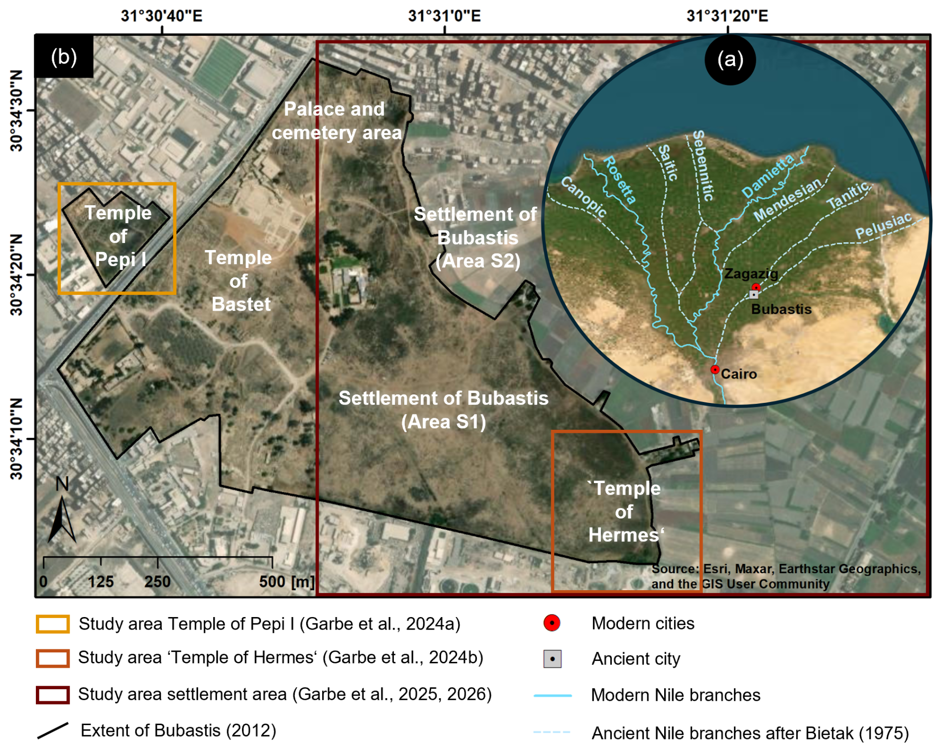
Figure 1Overview of the Nile Delta with suspected courses of ancient and modern Nile branches after Bietak (1975) (a), and current extent of the archeological site of ancient Bubastis with specific important ancient features together with the study areas of the previous articles from the author (b). Map data: © Esri, Maxar, Earthstar Geographics, and the GIS User Community.
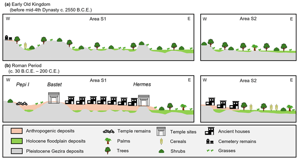
Using area-wide coring, electrical resistivity tomography (ERT), and direct-current resistivity (DCR) soundings, several Pleistocene sand mounds (Geziras) were identified (Fig. 2) that provided flood-safe locations for key buildings – such as the Temple of Pepi I in the west and the palace and the cemetery area in the north – as well as residential zones in eastern Bubastis (Garbe et al., 2024a, 2025). An additional mound can likely be linked to the lost Temple of Hermes in the southeastern part of Bubastis, supporting ancient writings and markings regarding the temple's possible location (Garbe et al., 2024b, 2025). The thickest anthropogenic deposits, reaching up to 9.5 m, were documented in settlement area S1, underscoring its zone function as the primary living quarter, particularly during the Ptolemaic (ca. 332–30 BCE) and Roman periods (ca. 30 BCE–200 CE). In contrast, the surrounding low-lying floodplain areas – especially area S2 – were only sparsely settled and were likely used for agriculture (Fig. 2), benefiting from nutrient-rich floodplain sediments regularly deposited by a nearby Nile branch located to the north and northeast of Bubastis.
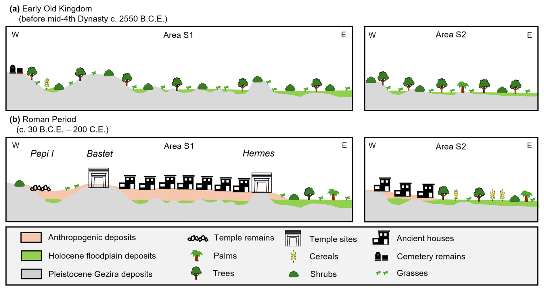
Figure 2Generalized model of Holocene landscape evolution in ancient Bubastis, shown for two time slices: Early Old Kingdom (a) and Roman Period (b). The sections include a cross-section in southern Bubastis (left) and a cross-section in northern Bubastis (right).
Phytolith analyses indicate pronounced shifts in vegetation patterns associated with human activity and urbanization. During the transition from the Late Pleistocene to the Early Holocene, the landscape was largely dominated by grasses, shrubs, and trees. From the Old Kingdom (ca. 2850–2180 BCE) onward, however, the onset of settlement activity coincided with a marked increase in cereal-type phytoliths. Their presence in nutrient-rich floodplain sediments provides the earliest evidence for localized cereal cultivation during the Early Old Kingdom (Fig. 2a) in Bubastis. In contrast, higher proportions of cereal-type phytoliths in anthropogenic deposits across the settlement – particularly in area S1 – point to intensive cereal processing and storage activities within residential zones. From the Late Period (ca. 664–332 BCE) through Roman times, cultivation practices increasingly shifted toward the settlement periphery as urban expansion progressed and natural vegetation diminished (Garbe, 2025; Garbe et al., 2026; Fig. 2b).
The findings underscore the close connection between environmental conditions and urban development at Bubastis. They suggest a dynamic interplay between nature and human adaptability, with different geomorphological settings being deliberately selected for specific functions and phases of occupation. The study thereby refines current interpretations of the city's emergence and growth and illustrates the value of geoarchaeological approaches for reconstructing human–environment interactions in the Nile Delta.