the Creative Commons Attribution 4.0 License.
the Creative Commons Attribution 4.0 License.
 | 17 May 2023
The past is the key to the future – considering Pleistocene subglacial erosion for the minimum depth of a radioactive waste repository
Anke Bebiolka
Vera Noack
Jörg Lang
Breuer, S., Bebiolka, A., Noack, V., and Lang, J.: The past is the key to the future – considering Pleistocene subglacial erosion for the minimum depth of a radioactive waste repository, E&G Quaternary Sci. J., 72, 113–125, https://doi.org/10.5194/egqsj-72-113-2023, 2023.
Erosion during potential future glaciations, especially the incision of deep tunnel valleys, is a major challenge for the long-term safety of a radioactive waste repository. Tunnel valleys are a common feature of formerly glaciated sedimentary basins and were incised by pressurised subglacial meltwater. Besides glaciological conditions, tunnel-valley formation depends strongly on the erodibility and hydraulic conductivity of the substratum. In northern Germany, tunnel valleys formed during the Pleistocene glaciations are widespread and may attain depths of almost 600 m. The Pleistocene record may provide an indication for the potential regional distribution and maximum depth of future glaciogenic erosion. We present a new overview map of the maximum depth of Pleistocene erosion in northern Germany. Depth zones were extracted from the existing data and maps provided by the state geological surveys. Based on the mapped depth zones, the potential for future tunnel-valley formation can be assessed. The map may serve as a base to define a spatially variable additional depth that should be added to the minimum depth of a repository required by legislation.
Erosion während möglicher zukünftiger Eiszeiten, insbesondere das Einschneiden tiefer subglazialer Rinnen, ist eine große Herausforderung für die Langzeitsicherheit eines Endlagers für hochradioaktive Abfälle. Subglaziale Rinnen sind in ehemals vergletscherten Sedimentbecken weit verbreitet und wurden durch subglaziales Schmelzwasser unter hohem Druck eingeschnitten. Außer durch glaziologische Faktoren wird die Bildung subglazialer Rinnen stark durch die Erodierbarkeit und die hydraulische Durchlässigkeit des Untergrundes bestimmt. In Norddeutschland sind pleistozäne subglaziale Rinnen weit verbreitet und erreichen Tiefen von fast 600 m. Die pleistozäne Überlieferung kann Hinweise auf die potenzielle regionale Verbreitung und maximale Tiefe zukünftiger glazigener Erosion liefern. Wir stellen eine neue Übersichtskarte der maximalen pleistozänen Erosionstiefe in Norddeutschland vor. Tiefenzonen wurden aus den existierenden Daten und Karten, die von den Staatlichen geologischen Diensten zur Verfügung gestellt wurden, extrahiert. Anhand der kartierten Tiefenzonen kann das Potenzial einer zukünftigen Bildung subglazialer Rinnen abgeschätzt werden. Die Karte kann als Grundlage zur Festlegung eines räumlich variablen Aufschlags zur gesetzlich vorgeschriebenen Mindesttiefe eines Endlagers dienen.
- Article
(8069 KB) - Full-text XML
-
Supplement
(1176 KB) - BibTeX
- EndNote


Tunnel valleys, although commonly no longer directly perceptible at the surface, are among the most impressive landforms related to former glaciations. Tunnel valleys are incised by pressurised meltwater beneath ice sheets and are an important component of the subglacial hydrological system (Kehew et al., 2012; van der Vegt et al., 2012). As overdeepened erosional landforms, tunnel valleys form independently of the regional base level and commonly reach depths of several hundreds of metres. The deepest Pleistocene tunnel valley in northern Germany, for example, has a depth of 554 m below sea level (b.s.l.; Schulz, 2002; Müller and Obst, 2008).
Subglacial erosion during potential future glaciations is a major challenge for the long-term safety of a repository for radioactive waste in deep geological formations. Future tunnel-valley incision is indirectly referred to as “intense erosion caused by an ice age” in the German Site Selection Act (StandAG, 2017). According to German legislation, the safety of a repository for high-level radioactive waste must be assessed for the next 1 million years (StandAG, 2017). Within this period, up to 10 glaciations could occur that may reach similar maximum extents as the Pleistocene glaciations (Fischer et al., 2021). Therefore, the impact of potential future glaciations on the safety of a repository must be considered. The Site Selection Act requires a minimum depth of the upper boundary of the effective containment zone (ECZ) of 300 m b.s.l. (StandAG, 2017). However, 300 m may be insufficient to safeguard the effective containment zone against the impact of deep subglacial erosion.
Assessing the potential for future tunnel-valley formation and its impact on a repository requires a thorough understanding of the processes and controlling factors of tunnel-valley formation. As the formation of tunnel valleys is controlled not only by geological but also by glaciological and climatic factors (Kehew et al., 2012; van der Vegt et al., 2012; Kirkham et al., 2022), predicting future incision is a major challenge. The dimensions and distribution of Pleistocene tunnel valleys may provide indications for future glaciogenic erosion. In this study, we describe a new approach to assessing the potential for future tunnel-valley formation based on the Pleistocene record. Our new approach is based on the assessment of the zones of maximum depth of the tunnel valleys and aims to recommend a minimum depth of the upper boundary of the effective containment zone (300 m or deeper), considering potential future tunnel-valley formation.
Tunnel valleys are characterised by undulating basal profiles, abrupt terminations, steep flanks and infills dominated by meltwater deposits (e.g. Kehew et al., 2012; van der Vegt et al., 2012). Various processes have been invoked for tunnel-valley formation, including erosion by meltwater, rivers or glaciers in subglacial or proglacial environments. Erosion by pressurised subglacial meltwater is now generally accepted as being responsible for tunnel-valley formation (Wingfield, 1990; Ó Cofaigh, 1996; Huuse and Lykke-Andersen, 2000b; Kehew et al., 2012; van der Vegt et al., 2012; Kirkham et al., 2022).
Subglacial meltwater conduits are crucial features in the drainage network of ice sheets, as the meltwater volumes are too large to be evacuated by groundwater flow (Piotrowski, 1997; Kehew et al., 2012). According to Clayton et al. (1999), tunnel channels can be defined as subglacial meltwater conduits with dimensions (width and depth) adapted to bankfull discharge. Tunnel channels are characterised by uniform dimensions along their course, lack tributaries and can commonly be linked to specific palaeo-ice-margin positions (Clayton et al., 1999). In contrast, tunnel valleys are higher-order, polyphase features, typically comprising multiple tunnel channels and their infills (Kehew et al., 2012). However, due to the wide variety of tunnel valleys and their infills, there is no single model that can explain all observations. Current models of tunnel-valley formation broadly fall into two groups: (i) erosion by steady-state meltwater discharge or (ii) erosion by sudden outbursts from meltwater reservoirs (cf. Kehew et al., 2012; van der Vegt et al., 2012; Kirkham et al., 2022).
-
(i) Tunnel-valley formation by steady-state meltwater discharge is a gradual process that requires the substratum of the ice sheet to be permeable, erodible and poorly lithified (Boulton and Hindmarsh, 1987; Boulton et al., 2009; Kehew et al., 2012; van der Vegt et al., 2012; Kirkham et al., 2022). Incision is caused by downcutting of subglacial tunnel channels that switch laterally in space and time, forming an anastomosing or anabranching pattern near the base of the evolving tunnel valley (Catania and Paola, 2001; Ravier et al., 2015; Kirkham et al., 2022). Modelling results by Kirkham et al. (2022) imply that the meltwater responsible for tunnel-valley formation is mainly derived from melting at the surface of the ice sheet. Tunnel-valley formation is furthermore impacted by the interplay between subglacial channelised meltwater discharge, groundwater flow and remobilisation of the bed (Boulton and Hindmarsh, 1987; Piotrowski et al., 1999; Janszen et al., 2013; Ravier et al., 2015). If the water pressure in the subglacial conduits remains lower than in the substratum, the pressure gradient causes a flow from the substratum into the conduits (Boulton et al., 2009). Creeping of soft sediment into the evolving tunnel valley enlarges incipient subglacial channels (Boulton and Hindmarsh, 1987). If the pressure gradient becomes sufficiently high, fluidisation of the substratum may occur that strongly enhances erosion (Boulton et al., 2009; Janszen et al., 2013). Vice versa, pressurised meltwater within a subglacial conduit may trigger hydrofracturing in the substratum that also leads to sediment remobilisation (Ravier et al., 2015). The water pressure beneath a warm-based ice sheet is highly variable in both space and time (Piotrowski et al., 2004), and zones of increased water pressure are prone to brecciation, liquefaction and fluidisation, allowing for a remobilisation of the subglacial bed and the gradual incision of tunnel valleys (Janszen et al., 2013; Ravier et al., 2014, 2015).
-
(ii) Outbursts of large volumes of stored meltwater with high flow velocities and discharge rates are another possible mechanism of tunnel-valley formation. Incision by meltwater outbursts is mainly related to retrograde erosion, causing the rapid enlargement of an initial meltwater pathway (Wingfield, 1990; Hooke and Jennings, 2006). Different models exist on the magnitudes, trigger mechanisms and recurrences of such subglacial outburst floods. Outburst floods may be responsible for the formation of individual tunnel channels (Hooke and Jennings, 2006; Sandersen et al., 2009) or tunnel valleys (Ehlers and Linke, 1989; Wingfield, 1990; Jørgensen and Sandersen, 2006). Meltwater storage in subglacial lakes is controlled by the hydraulic gradient, subglacial topography and the permeability of the substratum (Shreve, 1972; Piotrowski, 1994). The presence of permafrost, which lowers the permeability of the substratum and allows for the accumulation of meltwater reservoirs, is often considered a prerequisite for subglacial meltwater-reservoir formation (Piotrowski, 1994; Hooke and Jennings, 2006). Outbursts of stored meltwater occur if the pressure in the meltwater reservoir exceeds the strength of the impermeable substratum that forms the seal (Hooke and Jennings, 2006). Tunnel channels or valleys formed by meltwater outbursts afterwards serve as low-pressure meltwater conduits (Kehew et al., 2012). Episodic outbursts along the same pathway will eventually form larger tunnel valleys comprising multiple cut-and-fill sequences (Jørgensen and Sandersen, 2006).
Strong arguments exist both supporting and refuting the different models of tunnel-valley formation (cf. Ó Cofaigh, 1996; Kehew et al., 2012; van der Vegt et al., 2012; Kirkham et al., 2022). The widespread occurrence of tunnel valleys, however, suggests the existence of a common mechanism for their formation. In most instances, a formative model comprising quasi-steady-state meltwater discharge in combination with small outbursts is applicable to explain tunnel-valley formation (van der Vegt et al., 2012). In addition to erosion by meltwater, tunnel-valley evolution may be affected by erosion of the moving ice sheet and mass-wasting processes, which may enlarge tunnel valleys or modify their cross-sectional geometries and infills (Prins et al., 2020; Kirkham et al., 2021, 2022).
Tunnel-valley fills may indicate repeated episodes of erosion and deposition, which may relate to a single ice advance or multiple ice advances or extend across multiple glaciations (Piotrowski, 1994; Sandersen et al., 2009; Kirkham et al., 2022). The incision of tunnel valleys by meltwater is reflected by their infills, which are commonly dominated by meltwater deposits. Typically, tunnel-valley fills may be subdivided into synglacial and postglacial deposits (e.g. Piotrowski, 1994; Huuse and Lykke-Andersen, 2000b; Lang et al., 2012; van der Vegt et al., 2012; Janszen et al., 2013). Synglacial deposits comprise subglacial and ice-contact deposits formed during or immediately after incision and proglacial successions deposited during ice-sheet retreat. Meltwater deposits typically display fining-upward trends due to deposition at an increasing distance from the ice margin, with fine-grained glaciomarine or glaciolacustrine deposits forming the uppermost part of the synglacial successions. After deglaciation, remnant tunnel valleys commonly form local depocentres for postglacial marine, lacustrine or fluvial deposition (Ehlers and Linke, 1989; Piotrowski, 1994; Lang et al., 2012; Janszen et al., 2013; Lang et al., 2015; Steinmetz et al., 2015).
Tunnel-valley formation is controlled by glaciological and geological factors. Glaciological factors include the thickness and temperature of the ice sheet, which control the availability and pressure of the meltwater. Furthermore, tunnel valleys develop broadly parallel to the ice-flow direction. The geological control on tunnel-valley formation is mainly exerted by the erodibility and hydraulic conductivity of the substratum (Ó Cofaigh, 1996; Huuse and Lykke-Andersen, 2000b; Kehew et al., 2012; van der Vegt et al., 2012).
3.1 Substratum control
Tunnel valleys are generally restricted to areas with an easily erodible substratum as the infill of sedimentary basins. In areas characterised by resistant (e.g. crystalline) bedrock, eskers form instead of tunnel valleys (Boulton et al., 2009; Kehew et al., 2012).
In northern central Europe, the highest density of Pleistocene tunnel valleys and the deepest incisions occur in areas with thick, largely unlithified Cenozoic deposits (Hinsch, 1979; Kuster and Meyer, 1979; Ehlers and Linke, 1989; Stackebrandt et al., 2001; Stackebrandt, 2009; Lohrberg et al., 2020; Ottesen et al., 2020). Tunnel valleys, which were incised into more resistant (Mesozoic) rocks, are generally relatively shallow (Stackebrandt, 2009; Sandersen and Jørgensen, 2012). According to Stackebrandt (2009), Pleistocene tunnel valleys in northern Germany are concentrated in the area of the subsiding basin axis of the North German Basin, which was oriented approximately normal to the main ice-advance directions.
Tunnel-valley formation also depends on the hydraulic conductivity of the substratum. Initial subglacial incision commonly occurs if the substratum is unable to drain meltwater by groundwater flow, e.g. in areas of high meltwater production or low-permeability substrata (Piotrowski, 1997; Huuse and Lykke-Andersen, 2000b; Boulton et al., 2009; Kehew et al., 2012; Sandersen and Jørgensen, 2012). A layer-cake stratigraphy of high- and low-permeability strata favours the build-up of high pressures in subglacial aquifers, allowing for remobilisation of the sediment at the margins of tunnel valleys (Janszen et al., 2013; Ravier et al., 2014; Ravier et al., 2015).
3.2 Structural control
Faulting modifies the hydraulic conductivity and resistance to erosion of the affected rocks, thus creating structural weaknesses, which may act as preferential pathways of tunnel-valley incision (Wenau and Alves, 2020; Sandersen and Jørgensen, 2022). Sandersen and Jørgensen (2022) demonstrated a close correlation between the orientations of faults and tunnel valleys in Denmark, suggesting that the locations of many tunnel valleys are fault controlled. However, there are few studies showing a clear connection between faults and the incision of tunnel valleys (e.g. Al Hseinat et al., 2016; Wenau and Alves, 2020; Brandes et al., 2022). Furthermore, Stackebrandt (2009) suggested that also the terminations of tunnel valleys might be controlled by (neotectonically active) faults based on the observation of the simultaneous beginning and ending of parallel tunnel valleys.
Different interpretations exist on the impact of salt structures on tunnel-valley formation, based on observations that tunnel valleys may cross-cut, be parallel to or evade salt structures. Some tunnel valleys cut across salt structures, crestal faults and rim synclines without any perceptible interrelation (Grube, 1983; Ehlers and Linke, 1989; Sonntag and Lippstreu, 2010). In other cases, tunnel-valley incision is interpreted as having exploited pre-existing weaknesses related to salt structures, such as crestal faults or depressions related to the subsurface dissolution of evaporites (Kuster and Meyer, 1979; Ehlers and Linke, 1989; Huuse and Lykke-Andersen, 2000b; Lang et al., 2014; Wenau and Alves, 2020). Based on the interpretation of 3D seismic data from the southern North Sea, Wenau and Alves (2020) demonstrated that some tunnel valleys follow the trend of underlying salt structures and their crestal graben faults. In contrast, Kristensen et al. (2007) mapped tunnel valleys that circle around salt diapirs. Such changes in tunnel-valley trends may be explained by the uplift of more resistant sedimentary rocks at the flanks of salt structures (Kuster and Meyer, 1979) or by hydrogeological changes near salt structures (Piotrowski, 1997).
Northern Germany is one of the classic areas for tunnel-valley research, and tunnel valleys are a common feature in the areas that were covered by the Pleistocene ice sheets. Three major glaciations referred to as the Middle Pleistocene Elsterian and Saalian and the Late Pleistocene Weichselian glaciations are well documented (e.g. Litt et al., 2007; Ehlers et al., 2011). Pleistocene tunnel valleys in northern Germany are several hundred metres deep; are several hundred metres to a few kilometres, in extreme cases 8–12 km, wide; and can be longer than 100 km (e.g. Kuster and Meyer, 1979; Ehlers and Linke, 1989; Smed, 1998; Stackebrandt, 2009; Gegg and Preusser, 2023, and references therein).
Deep tunnel valleys characterise the base of the Quaternary across northern Germany and are generally interpreted as having formed during the Elsterian glaciation (Grube, 1979; Hinsch, 1979; Kuster and Meyer, 1979; Ehlers and Linke, 1989; Stackebrandt, 2009). The major trend of the tunnel valleys is north–south in northwestern Germany and northeast–southwest in northeastern Germany, which is generally interpreted as pointing to different ice-advance directions and probably a temporal change in the ice-advance directions (Ehlers and Linke, 1989; Stackebrandt, 2009). However, the tunnel valleys form a complex net-like anastomosing pattern and the controls on tunnel-valley orientations may be more complex. Major tunnel valleys display a regular spacing of 25 to 30 km (Stackebrandt, 2009). The deepest mapped Elsterian tunnel valley has a maximum depth of 554 m b.s.l. (Schulz, 2002; Müller and Obst, 2008). The deep (>200 m) Elsterian tunnel valleys were formed at a distance of at least 100 km inside the former ice margin. Shallower (<100 m) Elsterian tunnel valleys are known from areas close to the former ice-marginal position (e.g. Eissmann, 2002; Lang et al., 2012).
In contrast to the many and deep Elsterian tunnel valleys, Saalian tunnel valleys are generally considered rare (Passchier et al., 2010). The few tunnel valleys that have been attributed to the Saalian glaciation are commonly isolated and shallow (<100 m) features (e.g. Grube, 1979; Piotrowski, 1994; Piotrowski et al., 1999). Passchier et al. (2010) suggested that the lack of Saalian tunnel valleys may be related to different glaciological and hydrogeological conditions compared with the Elsterian glaciation. However, the attribution of the majority of tunnel valleys to the Elsterian glaciation is almost entirely based on lithostratigraphy.
The Weichselian glaciation had a lesser maximum extent than the Middle Pleistocene glaciations, covering only parts of northern Germany (Ehlers et al., 2011). Weichselian tunnel valleys are shallower (<100 m), shorter and narrower than their Elsterian counterparts (Smed, 1998; Stackebrandt, 2009). Weichselian tunnel valleys are visible in the present-day landscape as narrow depressions, commonly leading to the formation of lakes. In some instances, Weichselian tunnel valleys can be linked to palaeo-ice-marginal positions and outwash fans (Smed, 1998; Jørgensen and Sandersen, 2006).
As a database for this study, maps and models showing the base of the Quaternary provided by the state geological surveys of Schleswig-Holstein, Hamburg, Bremen, Lower Saxony, Saxony-Anhalt, Mecklenburg-Western Pomerania, Brandenburg and Berlin were used (Table 1). Most of the maps showing the base of the Quaternary were provided as line shapefiles by the state geological surveys.
Table 1The input data (maps and models of the base of the Quaternary) for each federal state, with data type, scale, year of publication and reference, as far as this information is known. “/” denotes no scale.

Currently, all northern German state geological surveys are in the process of revising their base Quaternary maps or creating 3D models of the medium-depth subsurface. The results of new boreholes and geophysical investigations and their interpretations will be used to update the maps of the base Quaternary and adapt them to the current state of research. However, the progress and planned completion dates of the individual federal states vary, so it was decided to work with the data that were available at the starting point of this project.
The base Quaternary maps were used as the main input data sets. The base of the Quaternary actually represents a diachronous basal surface of glaciogenic erosion, which can mostly be attributed to the Middle Pleistocene ice advances. As the focus of this project is on the areas with the deepest erosion, the investigations concentrate on the mapped tunnel valleys. For this purpose, the tunnel valleys were extracted from the respective base Quaternary maps of the federal states.
For data preparation, ArcMap (version 10.8.1) and ArcGIS Pro (version 2.9.1) were used. Merging the depth-contour maps of the individual federal states into a common map proved a major challenge. The use of different data sets, resolutions and mapping approaches led to major discontinuities at the state borders. Without data harmonisation and/or reinterpretation of the border areas, the maps could not be merged. However, such a reinterpretation was not possible within the time frame of our project. Therefore, the data for each federal state were considered individually in the first step.
The focus of this study was on the evaluation of areas with deep tunnel valleys. Therefore, the areas without clearly defined tunnel valleys and with an erosion depth of less than 100 m were removed from the data sets. After this manual processing, only the deep tunnel valleys remain visible on the map (Fig. 1).
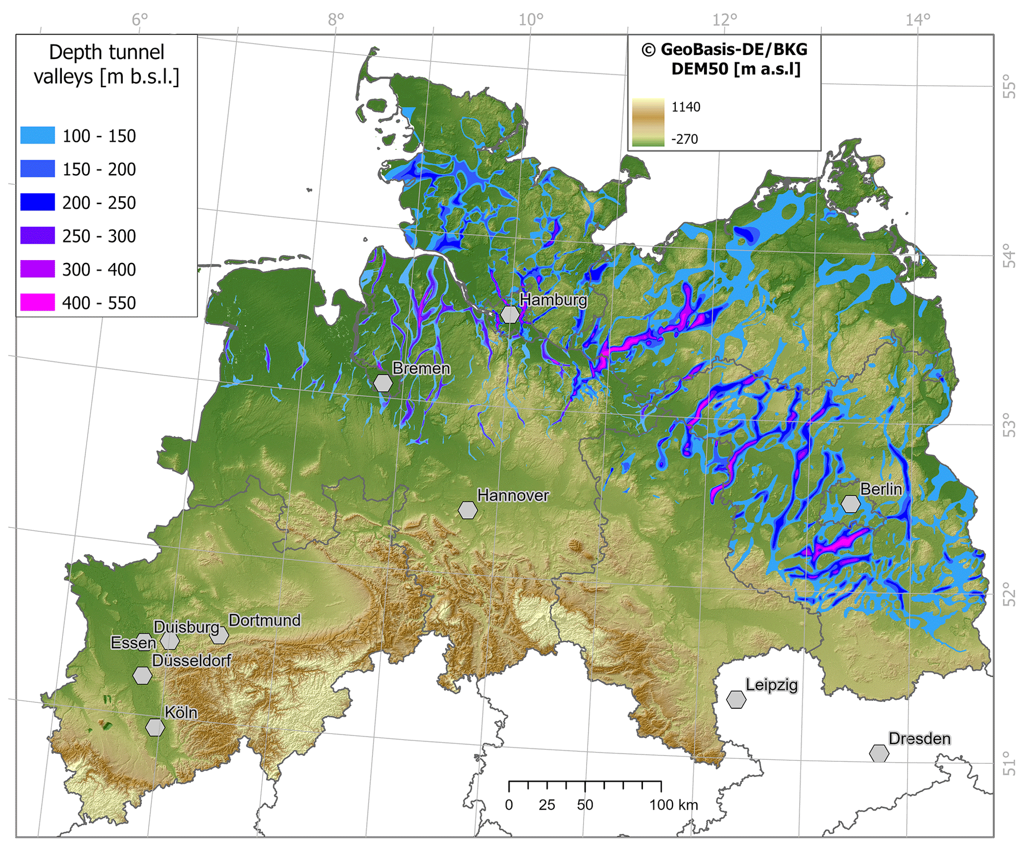
Figure 1Map showing the digital elevation model (DEM) of northern Germany with a cell size of 50 m (© GeoBasis-DE/BKG) and a raster of the tunnel valleys with a cell size of 100 m extracted from the base Quaternary data sets.
To further reduce the complexity of the base Quaternary maps, a geographic information system (GIS) workflow was developed to extract the thalweg lines of the tunnel valleys. The GIS workflow made it possible to extract the deepest points along the tunnel valleys. Details on the GIS workflow are provided in the Supplement (Figs. S1 and S2). Based on the map of the tunnel-valley thalwegs and their depths, zones of similar maximum tunnel-valley depths were defined.
Removing the areas from the base Quaternary maps that are shallower than 100 m b.s.l. provides a comprehensive overview of the Pleistocene tunnel-valley network (Fig. 1). The deepest parts and southern terminations of the tunnel valleys are both aligned in an approximately northwest–southeast-trending zone.
The extracted thalweg map allows for an easier recognition of individual tunnel valleys and their respective depths (Fig. 2). As each wide tunnel valley is now represented by a line of defined depth (Fig. 2), it becomes easier to identify zones of similar maximum depth (Fig. 3). Furthermore, the thalweg lines will be intersected with other geological structures and units to analyse their relationships and potential impact on the formation of the tunnel valleys in a subsequent step of our project. The visual analysis of the data showed that the tunnel valleys could be divided into five depth zones: no tunnel valley deeper than 100 m, up to 200 m, up to 300 m, up to 400 m and up to 600 m (Fig. 3), with the zone “no tunnel valley deeper than 100 m” extending to the maximum ice margin. The transitions between the depth zones are always placed at the terminations of the respective tunnel-valley sections and therefore occur abruptly. The depth zones of the tunnel valleys display a clear northwest–southeast-trending pattern. The deepest zone occurs in an area approximately between Hamburg and Berlin (Fig. 3). Towards the northeast and southwest, the maximum depths decrease successively.
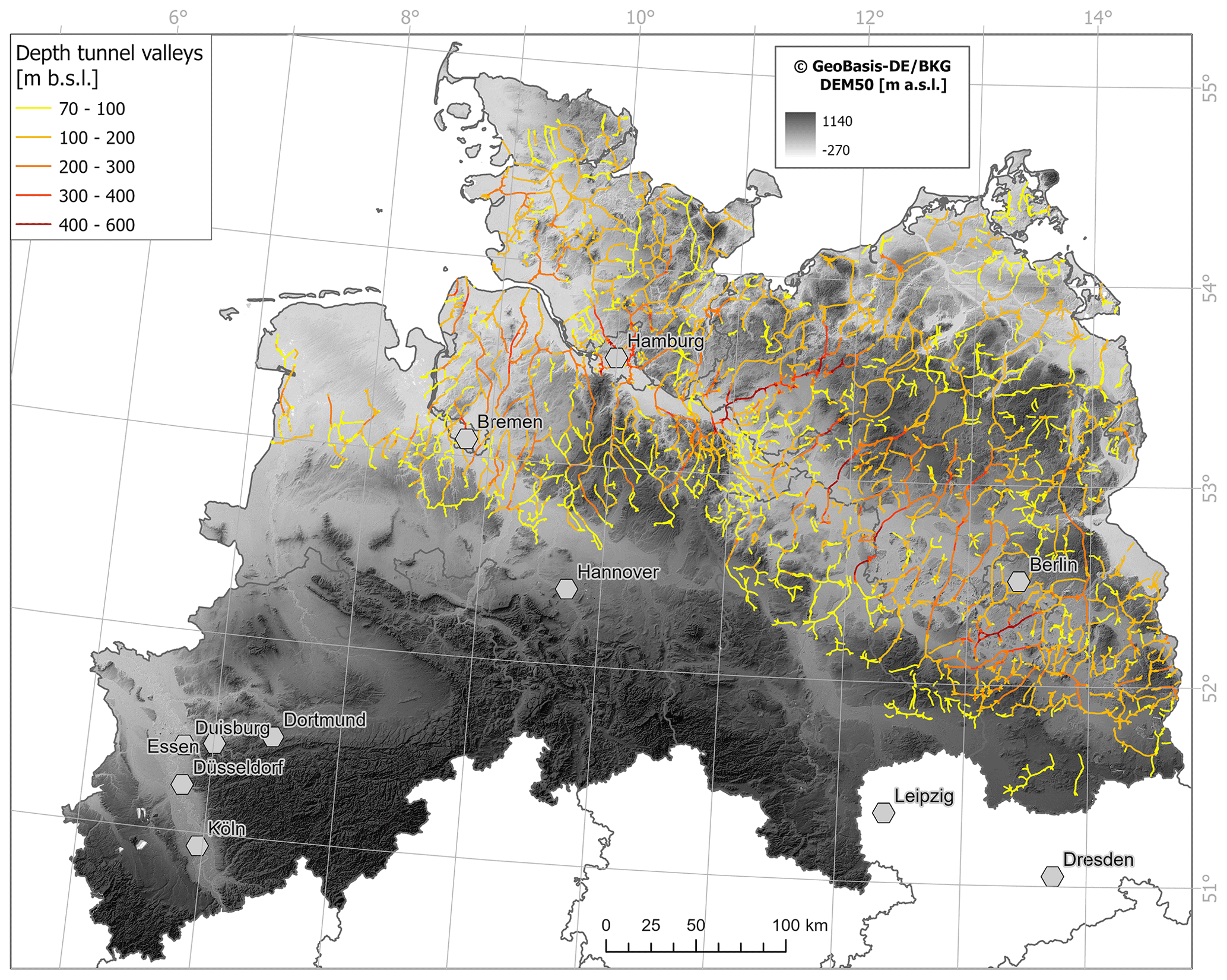
Figure 2Map showing the digital elevation model (DEM) of northern Germany with a cell size of 50 m (© GeoBasis-DE/BKG) and the result of the thalweg extraction. The depths of the thalweg lines are colour-coded.
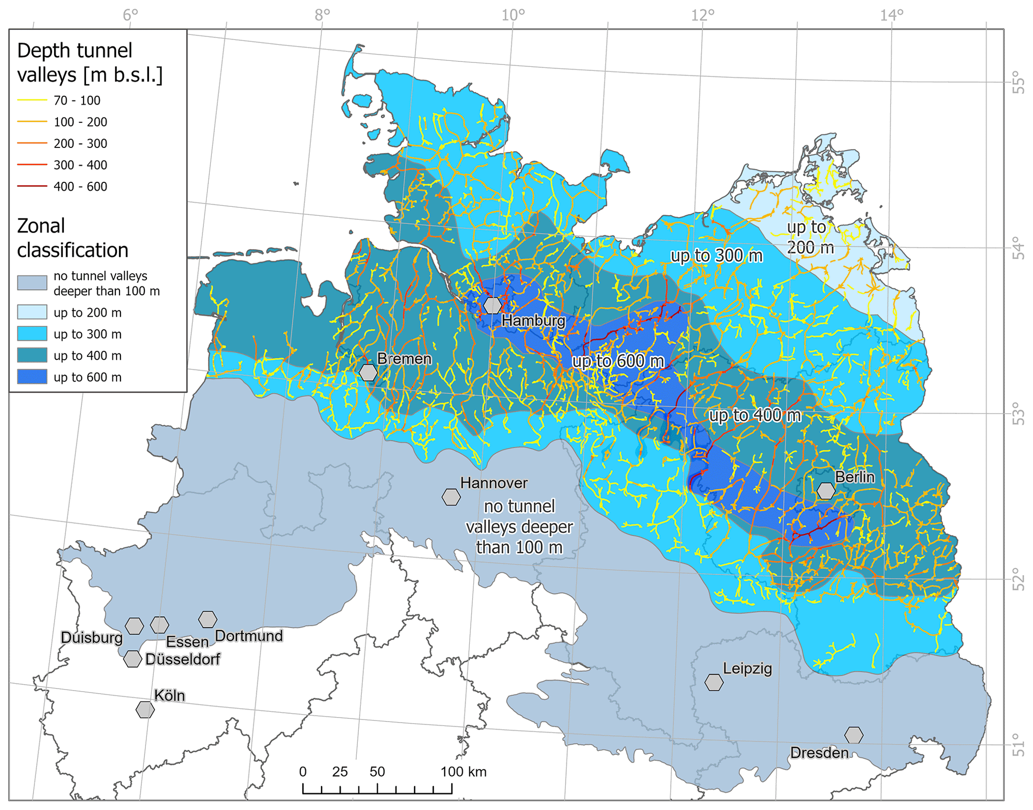
Figure 3Map showing the analysed depth zones of the tunnel valleys defined from the spatial distribution of the thalweg depths. Five different depth zones were defined.

Figure 4Block diagram showing a schematic section across the five zones of tunnel-valley depths.
We developed an effective and timesaving method to extract an overview map of the Pleistocene tunnel-valley network from the available data sets. The focus of the new map is on the distribution of the maximum depths rather than on individual tunnel valleys and their geometries.
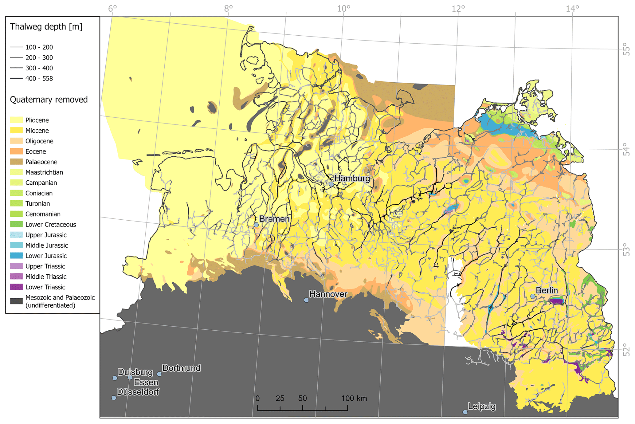
Figure 5Pre-Quaternary subcrop map (i.e. a map without the Quaternary deposits), which is a combination of the pre-Quaternary subcrop map of the Gorleben project (Brückner-Röhling et al., 2002) and the pre-Quaternary subcrop map of Mecklenburg-Western Pomerania at 1:500 000 (Schütze, 2006) and the pre-Quaternary subcrop map of Brandenburg from the Atlas zur Geologie von Brandenburg (Stackebrandt et al., 2010) at 1:1 000 000.
By calculating the thalweg lines, the map of the distribution and maximum depths of the tunnel valleys becomes much clearer and focussed on the major incisions (Fig. 2). When interpreting the course of the thalweg lines, however, it is important to bear in mind that the “Flow Accumulation” tool is a hydrological tool that always searches for connections downslope. Although tunnel valleys represent former drainage pathways, the tunnel-valley floors display undulating morphologies. This undulating morphology is characteristic of tunnel valleys and caused by the flow of pressurised water below an ice sheet (Kehew et al., 2012; van der Vegt et al., 2012). The derived thalweg maps represent a simplification of the complex tunnel-valley network. Therefore, the map of the thalweg lines should always be considered in combination with contoured depth maps, as otherwise the continuity of the tunnel valleys is underestimated.
The ultimate aim of our research is to assess the long-term safety of a repository for highly radioactive waste and, in particular, effects on the integrity of the effective containment zone (ECZ). The deepest tunnel valleys attain depths of more than 500 m (Fig. 3). Potential future erosion with similar depths may thus pose a risk to the ECZ. However, legislation only stipulates a required minimum depth of the top of the ECZ of 300 m b.s.l. (StandAG, 2017).
The depths of Pleistocene tunnel valleys clearly exceed the legally required minimum depth of 300 m. To minimise the risk posed by future tunnel-valley formation, an additional depth might be added to the minimum depth requirement. The mapped depth zones can be used to guide the definition of such an additional depth (Figs. 4 and 5).
The block diagram (Fig. 4) represents a schematic cross section across the Pleistocene tunnel valleys of northern Germany. Within the block diagram the geological bedrock is not further divided and therefore consists only of preglacial rocks and syn- and postglacial deposits. A dashed black line indicates the legally required minimum depth (A) of the repository (300 m). The dashed red line represents the envelope of the tunnel-valley bases. Deep tunnel valleys (>100 m) only occur near the maximum extent of the Pleistocene ice sheets. The greater the distance from the maximum ice-sheet extent, the greater the number and depth of the tunnel valleys. The calculated depth zones of the tunnel valleys (Fig. 3) are shown in the block diagram. Since the deepest tunnel valleys in northern Germany have only been formed in a spatially limited area, it is postulated that this will also be the case in the future. In the central area with the greatest tunnel-valley depths (up to 600 m), the final depth of the repository must be significantly below the depth of the tunnel valleys.
It has long been observed that tunnel valleys tend to form in certain areas that provide favourable conditions (e.g. Boulton et al., 2009; Stackebrandt, 2009; Kehew et al., 2012). Considering the depth and distribution of the tunnel valleys together with the pre-Quaternary subcrop map (i.e. a map without the Quaternary deposits; Fig. 5), it becomes clear that the majority of, and deepest, tunnel valleys occur in the central area of the basin, where poorly lithified and easily erodible Neogene sediments of the Pliocene and Miocene underlie the Quaternary deposits. In northeastern Mecklenburg-Western Pomerania, where more resistant Jurassic and Cretaceous rocks underlie the Quaternary deposits, significantly fewer and shallower tunnel valleys (Fig. 5) are present. Figure 6 shows the depth to near the base of the Cenozoic succession (top Danian Chalk Group; Doornenbal and Stevenson, 2010) together with the tunnel-valley thalwegs. For clarity, only thalweg depths greater than 200 m are shown. The map can be regarded as an approximate thickness map of the Cenozoic succession.

Figure 6Map showing the near base of the Cenozoic (top Danian Chalk Group) derived from the Southern Permian Basin Atlas (Doornenbal and Stevenson, 2010). The green lines show the thalweg lines of the tunnel valleys with depths ranging from 200 to 558 m.
The greatest depths of the tunnel-valley thalwegs are reached in the central basin area where the thickness of the Cenozoic sediments is highest. The location of the basin centre correlates with the majority of the deep tunnel valleys between 200 and 558 m b.s.l. (Fig. 6). The Palaeogene and Neogene units consist mainly of poorly lithified sands, silts and clays (Doornenbal and Stevenson, 2010). The greater erodibility of the poorly lithified sediments most likely favoured deep tunnel-valley incision (cf. Stackebrandt, 2009; Kehew et al., 2012).
Deep glaciogenic erosion is also caused by the formation of basins associated with glaciotectonic thrust complexes. Basins are formed beneath the ice sheet where thrust sheets are removed and transported to the ice margin to form glaciotectonic ridges (van der Wateren, 1995; Huuse and Lykke-Andersen, 2000a; Aber and Ber, 2007). Individual thrust sheets can be up to 250 m thick and can be transported for several kilometres (Kupetz, 1997; Huuse and Lykke-Andersen, 2000a; Winsemann et al., 2020). The depth of the basins and the thickness of the thrust sheets are controlled by the depth of the detachment, which typically consists of mechanically weak beds of clay, chalk or organic-rich sediments (Huuse and Lykke-Andersen, 2000a; Andersen et al., 2005; Aber and Ber, 2007). Detachments may occur in depths of up to 350 m (Huuse and Lykke-Andersen, 2000a; Aber and Ber, 2007). In northern Germany, glaciotectonic complexes with associated basins have formed during all major ice advances (Meyer, 1987; Van Der Wateren, 1995; Kupetz, 1997; Winsemann et al., 2020; Gehrmann et al., 2022). Glaciotectonic basins attain maximum depths between 120 and 290 m (Kupetz, 1997; Winsemann et al., 2020). However, as these basins are shallower than many tunnel valleys, they are not clearly visible on most maps of the base Quaternary.
Predicting future tunnel-valley formation is extremely challenging due to the complex glaciological and geological factors controlling tunnel-valley formation. The analysis of the Pleistocene record provides valuable insights into the patterns of tunnel-valley formation that will apply to the future processes. It seems plausible that areas where deep incision occurred during the Pleistocene glaciations may also be affected by future glaciogenic erosion. The favourable conditions for tunnel-valley formation are related to the overall regional geological setting, e.g. the setting in a sedimentary basin filled by poorly lithified and erodible deposits. The overall geological setting is unlikely to undergo major changes in the next 100 000 to 1 000 000 years. However, glaciations will strongly modify the morphology and near-surface geology. Therefore, in the case of multiple future glaciations, an assessment of potential tunnel-valley formation becomes even more challenging. Furthermore, multiple occupations of tunnel valleys may occur (e.g. Piotrowski, 1994; Jørgensen and Sandersen, 2006) and a reactivation of tunnel valleys during future glaciations cannot be ruled out.
For the recommendation of the depth zones, several assumptions need to be made with regard to (i) the available data of the study area, (ii) maximum tunnel-valley depths and (iii) the extent of future glaciations. The study area is sufficiently well explored, and maps of the existing tunnel valleys are available from the state geological surveys and other publications. The source data are very heterogeneous, with regional and local variations, as the published maps of the base Quaternary have been under constant revision since the 1970s. The overall density of data in the study area is very high, and we can assume that no major structures have been overlooked that would change the observed broad trends. However, new details of the Pleistocene tunnel-valley network are still being revealed by ongoing mapping (e.g. Hese et al., 2021; Bruns et al., 2022; Lohrberg et al., 2022a, b). With maximum depths of 554 m b.s.l., the tunnel valleys in northern Germany are among the deepest known tunnel valleys (Schulz, 2002; Müller and Obst, 2008; Stackebrandt, 2009). Similar extreme depths are known from the Netherlands (ten Veen, 2015) and the continental shelf off the east coast of North America (Macrae and Christians, 2013). However, the vast majority of tunnel valleys are shallower than 400 m (Kehew et al., 2012; van der Vegt et al., 2012; Ottesen et al., 2020). Therefore, very deep tunnel valleys can be considered extreme examples formed under favourable conditions. Future research should investigate these favourable conditions in more detail. A similar assumption applies to the potential extent of future glaciations, where the well-studied Pleistocene ice-sheet extents (e.g. Ehlers et al., 2011; Batchelor et al., 2019) serve as analogues for probable future glacial limits.
Subglacial tunnel valleys are among the deepest erosional landforms and are ubiquitous features of formerly glaciated sedimentary basins. Tunnel valleys are incised by pressurised meltwater and are thus formed independently of any regional base level. In addition to glaciological factors, tunnel-valley formation is strongly controlled by the geology of the substratum. The main geological controls are the resistance to erosion and the hydraulic conductivity.
Tunnel-valley formation during potential future glaciations needs to be included in the long-term safety assessment of radioactive waste repositories. As prediction of the location of future tunnel valleys is a major challenge, the new depth-zonation map provides a straightforward approach to assessing the potential for tunnel-valley formation based on the Pleistocene record. When recommending the minimum depth for a repository, the geology of the substratum should also be considered and its potential impact on tunnel-valley formation assessed.
The data that support the findings of this study are available from the corresponding author upon reasonable request.
The supplement related to this article is available online at: https://doi.org/10.5194/egqsj-72-113-2023-supplement.
Concept and design of the study: SB and JL; data compilation and analysis: SB; interpretation and discussion of the results: SB, AB, VN and JL; first draft of manuscript and figures: SB and JL. All authors approved the submitted version.
The contact author has declared that none of the authors has any competing interests.
Publisher’s note: Copernicus Publications remains neutral with regard to jurisdictional claims in published maps and institutional affiliations.
This article is part of the special issue “Subglacial erosional landforms and their relevance for the long-term safety of a radioactive waste repository”. It is the result of a virtual workshop held in December 2021.
We thank Mads Huuse, the anonymous reviewer and editor Sven Lukas for constructive comments, which greatly helped to improve the manuscript. The state geological surveys of Schleswig-Holstein, Hamburg, Bremen, Lower Saxony, Saxony-Anhalt, Mecklenburg-Western Pomerania, Brandenburg and Berlin are acknowledged for providing maps and data for this study. Discussions with Steffen Jahn, Nils-Peter Nilius, Maximilian Pfaff and Nadine Schöner helped to sharpen our ideas.
This paper was edited by Sven Lukas and reviewed by Mads Huuse and one anonymous referee.
Aber, J. S. and Ber, A.: Glaciotectonism, Developments in Quaternary Sciences, Elsevier, 256 pp., ISBN 9780444529435, 2007.
Al Hseinat, M., Hübscher, C., Lang, J., Lüdmann, T., Ott, I., and Polom, U.: Triassic to recent tectonic evolution of a crestal collapse graben above a salt-cored anticline in the Glückstadt Graben/North German Basin, Tectonophysics, 680, 50–66, https://doi.org/10.1016/j.tecto.2016.05.008, 2016.
Andersen, L. T., Hansen, D. L., and Huuse, M.: Numerical modelling of thrust structures in unconsolidated sediments: implications for glaciotectonic deformation, J. Struct. Geol., 27, 587–596, https://doi.org/10.1016/j.jsg.2005.01.005, 2005.
Batchelor, C. L., Margold, M., Krapp, M., Murton, D. K., Dalton, A. S., Gibbard, P. L., Stokes, C. R., Murton, J. B., and Manica, A.: The configuration of Northern Hemisphere ice sheets through the Quaternary, Nat. Commun., 10, 3713, https://doi.org/10.1038/s41467-019-11601-2, 2019.
Boulton, G. S. and Hindmarsh, R. C. A.: Sediment deformation beneath glaciers: Rheology and geological consequences, J. Geophys. Res.-Solid Earth, 92, 9059–9082, https://doi.org/10.1029/JB092iB09p09059, 1987.
Boulton, G. S., Hagdorn, M., Maillot, P. B., and Zatsepin, S.: Drainage beneath ice sheets: groundwater–channel coupling, and the origin of esker systems from former ice sheets, Quaternary Sci. Rev., 28, 621–638, https://doi.org/10.1016/j.quascirev.2008.05.009, 2009.
Brandes, C., Polom, U., Winsemann, J., and Sandersen, P. B. E.: The near-surface structure in the area of the Børglum fault, Sorgenfrei-Tornquist Zone, northern Denmark: Implications for fault kinematics, timing of fault activity and fault control on tunnel valley formation, Quaternary Sci. Rev., 289, 107619, https://doi.org/10.1016/j.quascirev.2022.107619, 2022.
Brückner-Röhling, S., Espig, M., Fischer, M., Fleig, S., Forsbach, H., Kockel, F., Krull, P., Stiewe, H., and Wirth, H.: Standsicherheitsnachweise Nachbetriebsphase: Seismische Gefährdung – Teil 1: Strukturgeologie, Bundesanstalt für Geowissenschaften und Rohstoffe (BGR), Hannover, BGR-Bericht, 253, 2002.
Bruns, I., Fischer, K., Meinsen, J., and Wangenheim, C.: Eine aktualisierte Quartärbasis für Niedersachsen – Erste Einblicke in die Modellierung, DEUQUA “Connecting Geoarchives, Potsdam, 1 p., https://doi.org/10.48440/GFZ.b103-22024, 2022.
Catania, G. and Paola, C.: Braiding under glass, Geology, 29, 259–262, https://doi.org/10.1130/0091-7613(2001)029{%}3C0259:BUG{%}3E2.0.CO;2, 2001.
Clayton, L., Attig, J. W., and Mickelson, D. M.: Tunnel channels formed in Wisconsin during the last glaciation, in: Glacial Processes Past and Present, edited by: Mickelson, D. M. and Attig, J. W., Geological Society of America, https://doi.org/10.1130/0-8137-2337-x.69, 1999.
Doornenbal, H. and Stevenson, A.: Petroleum Geological Atlas of the Southern Permian Basin Area, EAGE Publications b.v. (Houten), ISBN 978-90-73781-61-0, 2010.
Ehlers, J. and Linke, G.: The origin of deep buried channels of Elsterian age in Northwest Germany, J. Quaternary Sci., 4, 255–265, https://doi.org/10.1002/jqs.3390040306, 1989.
Ehlers, J., Grube, A., Stephan, H.-J., and Wansa, S.: Pleistocene Glaciations of North Germany – New Results, in: Developments in Quaternary Sciences, edited by: Ehlers, J., Gibbard, P. L., and Hughes, P. D., Elsevier, 149–162, https://doi.org/10.1016/B978-0-444-53447-7.00013-1, 2011.
Eissmann, L.: Quaternary geology of eastern Germany (Saxony, Saxon–Anhalt, South Brandenburg, Thüringia), type area of the Elsterian and Saalian Stages in Europe, Quaternary Sci. Rev., 21, 1275–1346, https://doi.org/10.1016/S0277-3791(01)00075-0, 2002.
Fischer, U. H., Bebiolka, A., Brandefelt, J., Cohen, D., Harper, J., Hirschorn, S., Jensen, M., Kennell, L., Liakka, J., Näslund, J.-O., Normani, S., Stück, H., and Weitkamp, A.: Radioactive waste under conditions of future ice ages, in: Snow and Ice-Related Hazards, Risks, and Disasters (Second Edition), edited by: Haeberli, W. and Whiteman, C., Elsevier, 323–375, https://doi.org/10.1016/B978-0-12-817129-5.00005-6, 2021.
Gegg, L. and Preusser, F.: Comparison of overdeepened structures in formerly glaciated areas of the northern Alpine foreland and northern central Europe, E&G Quaternary Sci. J., 72, 23–36, https://doi.org/10.5194/egqsj-72-23-2023, 2023.
Gehrmann, A., Pedersen, S. A. S., and Meschede, M.: New insights into the structural development and shortening of the southern Jasmund Glacitectonic Complex (Rügen, Germany) based on balanced cross sections, Int. J. Earth Sci., 111, 1697–1715, https://doi.org/10.1007/s00531-022-02216-y, 2022.
Grube, F.: Übertiefte Rinnen im Hamburger Raum, E&G Quaternary Sci. J., 29, 157–172, https://doi.org/10.3285/eg.29.1.13, 1979.
Grube, F.: Tunnel Valleys, in: Glacial Deposits in North-West Europe, edited by: Ehlers, J., A. A. Balkema, Rotterdam, 257–258, 1983.
Hese, F., Ahlers, P., Krienke, K., and Neumann, T.: Neubearbeitung der Quartärbasis in Schleswig-Holstein, Subglaziale Rinnen Workshop 2021, Poster, 10 December 2021, Hannover, 2021.
Hinsch, W.: Rinnen an der Basis des glaziären Pleistozäns in Schleswig-Holstein, E&G Quaternary Sci. J., 29, 173–178, https://doi.org/10.3285/eg.29.1.14, 1979.
Hooke, R. L. and Jennings, C. E.: On the formation of the tunnel valleys of the southern Laurentide ice sheet, Quaternary Sci. Rev., 25, 1364–1372, https://doi.org/10.1016/j.quascirev.2006.01.018, 2006.
Huuse, M. and Lykke-Andersen, H.: Large-scale glaciotectonic thrust structures in the eastern Danish North Sea, Geological Society, London, Special Publications, 176, 293–305, https://doi.org/10.1144/GSL.SP.2000.176.01.22, 2000a.
Huuse, M. and Lykke-Andersen, H.: Overdeepened Quaternary valleys in the eastern Danish North Sea: morphology and origin, Quaternary Sci. Rev., 19, 1233–1253, https://doi.org/10.1016/S0277-3791(99)00103-1, 2000b.
Janszen, A., Moreau, J., Moscariello, A., Ehlers, J., and Kröger, J.: Time-transgressive tunnel-valley infill revealed by a three-dimensional sedimentary model, Hamburg, north-west Germany, Sedimentology, 60, 693–719, https://doi.org/10.1111/j.1365-3091.2012.01357.x, 2013.
Jørgensen, F. and Sandersen, P. B. E.: Buried and open tunnel valleys in Denmark – erosion beneath multiple ice sheets, Quaternary Sci. Rev.,, 25, 1339–1363, https://doi.org/10.1016/j.quascirev.2005.11.006, 2006.
Kehew, A., Piotrowski, J., and Jørgensen, F.: Tunnel valleys: Concepts and controversies – A review, Earth-Sci. Rev., 113, 33–58, https://doi.org/10.1016/j.earscirev.2012.02.002, 2012.
Kirkham, J. D., Hogan, K. A., Larter, R. D., Self, E., Games, K., Huuse, M., Stewart, M. A., Ottesen, D., Arnold, N. S., and Dowdeswell, J. A.: Tunnel valley infill and genesis revealed by high-resolution 3-D seismic data, Geology, 49, 1516–1520, https://doi.org/10.1130/g49048.1, 2021.
Kirkham, J. D., Hogan, K. A., Larter, R. D., Arnold, N. S., Ely, J. C., Clark, C. D., Self, E., Games, K., Huuse, M., Stewart, M. A., Ottesen, D., and Dowdeswell, J. A.: Tunnel valley formation beneath deglaciating mid-latitude ice sheets: Observations and modelling, Quaternary Sci. Rev., 107680, https://doi.org/10.1016/j.quascirev.2022.107680, 2022.
Kristensen, T. B., Huuse, M., Piotrowski, J. A., and Clausen, O. R.: A morphometric analysis of tunnel valleys in the eastern North Sea based on 3D seismic data, J. Quaternary Sci., 22, 801–815, https://doi.org/10.1002/jqs.1123, 2007.
Kupetz, M.: Geologischer Bau und Genese der Stauchendmoräne Muskauer Faltenbogen, Brandenburgische Geowissenschaftliche Beiträge, 4, 1–20, http://www.schweizerbart.de//publications/detail/isbn/9783510652952/Stackebrandt_Franke_Geologie_von_Brande (last access: 17 May 2023), 1997.
Kuster, H. and Meyer, K. D.: Glaziäre Rinnen im mittleren und nördlichen Niedersachsen, E&G Quaternary Sci. J., 29, 135–156, https://doi.org/10.3285/eg.29.1.12, 1979.
Lang, J., Winsemann, J., Steinmetz, D., Polom, U., Pollok, L., Böhner, U., Serangeli, J., Brandes, C., Hampel, A., and Winghart, S.: The Pleistocene of Schöningen, Germany: a complex tunnel valley fill revealed from 3D subsurface modelling and shear wave seismics, Quaternary Sci. Rev., 39, 86–105, https://doi.org/10.1016/j.quascirev.2012.02.009, 2012.
Lang, J., Hampel, A., Brandes, C., and Winsemann, J.: Response of salt structures to ice-sheet loading: implications for ice-marginal and subglacial processes, Quaternary Sci. Rev., 101, 217–233, https://doi.org/10.1016/j.quascirev.2014.07.022, 2014.
Lang, J., Böhner, U., Polom, U., Serangeli, J., and Winsemann, J.: The Middle Pleistocene tunnel valley at Schöningen as a Paleolithic archive, J. Human Evolut., 89, 18–26, https://doi.org/10.1016/j.jhevol.2015.02.004, 2015.
Litt, T., Behre, K.-E., Meyer, K.-D., Stephan, H.-J., and Wansa, S.: Stratigraphische Begriffe für das Quartär des norddeutschen Vereisungsgebietes, E&G Quaternary Sci. J., 56, 7–65, https://doi.org/10.3285/eg.56.1-2.02, 2007.
Lohrberg, A., Schwarzer, K., Unverricht, D., Omlin, A., and Krastel, S.: Architecture of tunnel valleys in the southeastern North Sea: new insights from high-resolution seismic imaging, J. Quatern. Sci., 35, 892–906, https://doi.org/10.1002/jqs.3244, 2020.
Lohrberg, A., Krastel, S., Unverricht, D., and Schwarzer, K.: The Heligoland Glacitectonic Complex in the southeastern North Sea: indicators of a pre- or early-Elsterian ice margin, Boreas, 51, 100–117, https://doi.org/10.1111/bor.12551, 2022a.
Lohrberg, A., Schneider von Deimling, J., Grob, H., Lenz, K.-F., and Krastel, S.: Tunnel valleys in the southeastern North Sea: more data, more complexity, E&G Quaternary Sci. J., 71, 267–274, https://doi.org/10.5194/egqsj-71-267-2022, 2022b.
MacRae, R. A. and Christians, A. R.: A reexamination of Pleistocene tunnel valley distribution on the central Scotian Shelf, Can. J. Earth Sci., 50, 535–544, https://doi.org/10.1139/cjes-2012-0057, 2013.
Meyer, K. D.: Ground and end moraines in Lower Saxony, in: Tills and Glaciotectonics, edited by: van der Meer, J. J. M., Balkema, Rotterdam, 197–204, ISBN 0317650114, 1987.
Müller, U. and Obst, K.: Junge halokinetische Bewegungen im Bereich der Salzkissen Schlieven und Marnitz in Südwest-Mecklenburg, Brandenburg. geowiss. Beitr., 15, 147–145, https://www.schweizerbart.de/publications/detail/isbn/9783510652952/Stackebrandt/_Franke/_Geologie_von_Brande (last access: 17 May 2023), 2008.
Noack, V., Cherubini, Y., Scheck-Wenderoth, M., Lewerenz, B., Höding, T., Simon, A., and Moeck, I. S.: Assessment of the present-day thermal field (NE German Basin) – Inferences from 3D modelling, Geochemistry, 70, 47–62, https://doi.org/10.1016/j.chemer.2010.05.008, 2010.
Ó Cofaigh, C.: Tunnel valley genesis, Prog. Phys. Geog.-Earth Environ., 20, 1–19, https://doi.org/10.1177/030913339602000101, 1996.
Ottesen, D., Stewart, M., Brönner, M., and Batchelor, C. L.: Tunnel valleys of the central and northern North Sea (56∘ N to 62∘ N): Distribution and characteristics, Mar. Geol., 425, 106199, https://doi.org/10.1016/j.margeo.2020.106199, 2020.
Passchier, S., Laban, C., Mesdag, C. S., and Rijsdijk, K. F.: Subglacial bed conditions during Late Pleistocene glaciations and their impact on ice dynamics in the southern North Sea, Boreas, 39, 633–647, https://doi.org/10.1111/j.1502-3885.2009.00138.x, 2010.
Piotrowski, J. A.: Tunnel-valley formation in northwest Germany – geology, mechanisms of formation and subglacial bed conditions for the Bornhöved tunnel valley, Sediment. Geol., 89, 107–141, https://doi.org/10.1016/0037-0738(94)90086-8, 1994.
Piotrowski, J. A.: Subglacial hydrology in north-western Germany during the last glaciation: groundwater flow, tunnel valleys and hydrological cycles, Quaternary Sci. Rev., 16, 169–185, https://doi.org/10.1016/S0277-3791(96)00046-7, 1997.
Piotrowski, J. A., Geletneky, J., and Vater, R.: Soft-bedded sub-glacial meltwater channel from Welzow-Süd open-cast lignite mine, Lower Lusatia, eastern Germany, Boreas, 28, 363–374, https://doi.org/10.1111/j.1502-3885.1999.tb00226.x, 1999.
Piotrowski, J. A., Larsen, N. K., and Junge, F. W.: Reflections on soft subglacial beds as a mosaic of deforming and stable spots, Quaternary Sci. Rev., 23, 993–1000, https://doi.org/10.1016/j.quascirev.2004.01.006, 2004.
Prins, L. T., Andresen, K. J., Clausen, O. R., and Piotrowski, J. A.: Formation and widening of a North Sea tunnel valley – The impact of slope processes on valley morphology, Geomorphology, 368, 107347, https://doi.org/10.1016/j.geomorph.2020.107347, 2020.
Ravier, E., Buoncristiani, J.-F., Guiraud, M., Menzies, J., Clerc, S., Goupy, B., and Portier, E.: Porewater pressure control on subglacial soft sediment remobilization and tunnel valley formation: A case study from the Alnif tunnel valley (Morocco), Sediment. Geol., 304, 71–95, https://doi.org/10.1016/j.sedgeo.2014.02.005, 2014.
Ravier, E., Buoncristiani, J.-F., Menzies, J., Guiraud, M., Clerc, S., and Portier, E.: Does porewater or meltwater control tunnel valley genesis? Case studies from the Hirnantian of Morocco, Palaeogeogr. Palaeocl., 418, 359–376, https://doi.org/10.1016/j.palaeo.2014.12.003, 2015.
Sandersen, P. B. E. and Jørgensen, F.: Substratum control on tunnel-valley formation in Denmark, in: Glaciogenic Reservoirs and Hydrocarbon Systems, edited by: Huuse, M., Redfern, J., Le Heron, D. P., Dixon, R. J., Moscariello, A., and Craig, A., Geological Society Special Publications, 1, Geological Society of London, London/UK, 145–157, https://doi.org/10.1144/SP368.12, 2012.
Sandersen, P. B. E. and Jørgensen, F.: Tectonic impact on Pleistocene and Holocene erosional patterns in a formerly glaciated intra-plate area, Quaternary Sci. Rev., 293, 107681, https://doi.org/10.1016/j.quascirev.2022.107681, 2022.
Sandersen, P. B. E., Jørgensen, F., Larsen, N. K., Westergaard, J. H., and Auken, E.: Rapid tunnel-valley formation beneath the receding Late Weichselian ice sheet in Vendsyssel, Denmark, Boreas, 38, 834–851, https://doi.org/10.1111/j.1502-3885.2009.00105.x, 2009.
Schulz, R.: Forschungsbohrungen des GGA-Instituts, Zeitschrift für angewandte Geologie, 48, 3–8, ISSN 0044-2259, 2002.
Schütze, K.: Übersichtskarte Präquartär und Quartärbasis, Landesamt für Umwelt, Naturschutz und Geologie Mecklenburg-Vorpommern (LUNG), Geologische Karte von Mecklenburg-Vorpommern 1:500.000, 2006.
Shreve, R. L.: Movement of Water in Glaciers, J. Glaciol., 11, 205–214, https://doi.org/10.3189/S002214300002219X, 1972.
Smed, P.: Die Entstehung der dänischen und norddeutschen Rinnentäler (Tunneltäler) – Glaziologische Gesichtspunkte, E&G Quaternary Sci. J., 48, 1–18, https://doi.org/10.3285/eg.48.1.01, 1998.
Sonntag, A. and Lippstreu, L.: Tiefenlage der Quartärbasisfläche, in: Atlas zur Geologie von Brandenburg, 4. aktualisierte Auflage ed., edited by: Stackebrandt, W. and Manhenke, V., Landesamt für Bergbau, Geologie und Rohstoffe Brandenburg (LBGR), Cottbus, 54–55, ISBN 978-3-9808157-4-1, 2010.
Stackebrandt, W.: Subglacial channels of Northern Germany – a brief review, Zeitschrift der Deutschen Gesellschaft für Geowissenschaften, 160, 203–210, https://doi.org/10.1127/1860-1804/2009/0160-0203, 2009.
Stackebrandt, W., Ludwig, A. O., and Ostaficzuk, S.: Base of Quaternary deposits of the Baltic Sea depression and adjacent areas (Map 2), Brandenburgische geowissenschaftliche Beiträge, 8, 13–19, https://lbgr.brandenburg.de/lbgr/de/geologischer-dienst/brandenburgische-geowissenschaftliche-beitraege/ (last access: 17 May 2023), 2001.
Stackebrandt, W., Manhenke, V., Stackebrandt, W., Andreae, A., and Strahl, J. (Eds.): Atlas zur Geologie von Brandenburg, 4. aktualisierte Auflage, Landesamt für Bergbau, Geologie und Rohstoffe Brandenburg (LBGR), Cottbus, 157 pp., ISBN 978-3-9808157-4-1, 2010.
StandAG: Gesetz zur Suche und Auswahl eines Standortes für ein Endlager für hochradioaktive Abfälle (Standortauswahlgesetz – StandAG) vom 5. Mai 2017 (BGBl. I 2017, Nr. 26, S. 1074) zuletzt geändert durch Artikel 3 des Gesetzes vom 12. Dezember 2019 (BGBl. I 2019, Nr. 48, S. 2510), Stand 01/20, Deutscher Bundestag, 2017.
Steinmetz, D., Winsemann, J., Brandes, C., Siemon, B., Ullmann, A., Wiederhold, H., and Meyer, U.: Towards an improved geological interpretation of airborne electromagnetic data: a case study from the Cuxhaven tunnel valley and its Neogene host sediments (northwest Germany), Netherlands J. Geosci., 94, 201–227, https://doi.org/10.1017/njg.2014.39, 2015.
ten Veen, J.: Future evolution of the geological and geohydrological properties of the geosphere, TNO, Utrecht, OPERA-PU-TNO412, 121, Utrecht, OPERA, 2015.
van der Vegt, P., Janszen, A., and Moscariello, A.: Tunnel valleys: current knowledge and future perspectives, Geological Society, London, Special Publications, 368, 75–97, https://doi.org/10.1144/sp368.13, 2012.
van der Wateren, F. M.: Structural geology and sedimentology of push moraines: processes of soft sediment deformation in a glacial environment and the distribution of glaciotectonic styles, Mededelingen Rijks Geologische Dienst, 54, 167 pp., ISSN 90-72869-44-3, 1995.
Wenau, S. and Alves, T. M.: Salt-induced crestal faults control the formation of Quaternary tunnel valleys in the southern North Sea, Boreas, 49, 799–812, https://doi.org/10.1111/bor.12461, 2020.
Wingfield, R.: The origin of major incisions within the Pleistocene deposits of the North Sea, Mar. Geol., 91, 31–52, https://doi.org/10.1016/0025-3227(90)90131-3, 1990.
Winsemann, J., Koopmann, H., Tanner, D. C., Lutz, R., Lang, J., Brandes, C., and Gaedicke, C.: Seismic interpretation and structural restoration of the Heligoland glaciotectonic thrust-fault complex: Implications for multiple deformation during (pre-)Elsterian to Warthian ice advances into the southern North Sea Basin, Quaternary Sci. Rev., 227, 106068, https://doi.org/10.1016/j.quascirev.2019.106068, 2020.
- How to cite
- Abstract
- Kurzfassung
- Introduction
- Processes of tunnel-valley formation
- Controlling factors of tunnel-valley formation
- Pleistocene tunnel valleys in northern Germany
- Data
- Methods
- Results
- Discussion
- Conclusions
- Data availability
- Author contributions
- Competing interests
- Disclaimer
- Special issue statement
- Acknowledgements
- Review statement
- References
- Supplement