the Creative Commons Attribution 4.0 License.
the Creative Commons Attribution 4.0 License.
 | 16 May 2023
Late Weichselian–Holocene valley development of the Elbe valley near Dresden – linking sedimentation, soil formation and archaeology
Christian Tinapp
Johannes Selzer
Norman Döhlert-Albani
Birgit Fischer
Susann Heinrich
Christoph Herbig
Frauke Kreienbrink
Tobias Lauer
Birgit Schneider
Harald Stäuble
Tinapp, C., Selzer, J., Döhlert-Albani, N., Fischer, B., Heinrich, S., Herbig, C., Kreienbrink, F., Lauer, T., Schneider, B., and Stäuble, H.: Late Weichselian–Holocene valley development of the Elbe valley near Dresden – linking sedimentation, soil formation and archaeology, E&G Quaternary Sci. J., 72, 95–111, https://doi.org/10.5194/egqsj-72-95-2023, 2023.
Valley infills are essential for understanding changes in hydrology and landscape. Anthropogenic activities are proven by prehistoric settlement remains, which mark distinct sediments and soils as usable land during certain time periods. In 2009 and 2018/19, excavations by the Saxonian Archaeological Heritage Office were conducted in the Elbe valley between Meißen and Dresden, preceding the construction of two natural gas pipelines. As a result, two important multicultural prehistoric sites were discovered on the Lower Weichselian Terrace (LWT) in different sediments and on varying stratigraphic levels.
During this study sediments and soils at the excavation sites and throughout the pipe trench have been documented. Micromorphological, sedimentological and geochemical investigations and analyses of archaeobotanical and archaeological finds, complemented by 14C and optically stimulated luminescence (OSL) dating, enabled deciphering the structure of sediments and soils. Two major sites were the focus. At the Clieben site, an early Neolithic settlement and former topsoil, developed in a Weichselian valley loam above gravels and sands, are covered by younger overbank fines. At the Brockwitz site, shallow incision channels in the LWT were filled with clayey overbank fines during the Preboreal. An overprinting humic soil horizon was later anthropogenically overprinted during the early and middle Neolithic period. An omnipresent layer of Subboreal or younger overbank fines, covering the majority of the LWT in combination with the spatially confined Preboreal overbank fines, mirrors the ever-growing risk of flooding in a formerly attractive settlement area.
Talsedimente erlauben wichtige Einblicke in Veränderungen der Landschaft und der Hydrologie. Prähistorische anthropogene Aktivitäten hinterlassen Spuren in Sediment und Boden, die für bestimmte Phasen die Nutzbarkeit belegen. In den Jahren 2009 und 2018/19 führte der Bau von zwei Erdgasleitungen zu Ausgrabungen des Landesamtes für Archäologie Sachsen im Elbetal zwischen Meißen und Dresden. Zwei mehrphasige Siedlungsplätze wurden auf der Tieferen Niederterrasse (Lower Weichselian Terrace, LWT) entdeckt. Die Funde lagen in unterschiedlichen Sedimenten auf verschiedenen stratigraphischen Niveaus. Im Rahmen der Arbeiten wurden Sedimente und Böden im Bereich der Ausgrabungsplätze und im Bereich des Rohrgrabens aufgenommen. Mikromorphologische, sedimentologische, geochemische Untersuchungen, archäobotanische und archäologische Funde sowie 14C- und OSL-Datierungen ermöglichen die zeitliche Einordnung der Sedimente und Böden. Dabei stehen zwei größere Areale im Fokus. Im Cliebener Untersuchungsareal liegen frühneolithische Siedlungsreste im Bereich eines begrabenen Bodens aus weichselzeitlichem Tallehm über Kiesen und Sanden, die von jüngeren Auenlehmen überdeckt werden. Im Brockwitzer Untersuchungsareal befinden sich flach eingeschnittene Rinnen in der LWT, die bereits im Präboreal mit tonigem Lehm verfüllt wurden. Ein in diesen Sedimenten entstandener humoser Oberbodenhorizont wurde durch anthropogene Aktivitäten während des Früh- und Mittelneolithikums überprägt. Nahezu die gesamte LWT wird von jüngeren Auenlehmen überdeckt, die seit dem Subboreal abgelagert wurden. Dies belegt die zunehmende Gefahr von Überschwemmungen auf einer ehemals siedlungsgünstigen Terrassenfläche.
- Article
(18433 KB) - Full-text XML
-
Supplement
(30266 KB) - BibTeX
- EndNote


Archaeological sites in river valleys are important sources to reconstruct the Late Pleistocene–Holocene landscape development. This is due to the fact that prehistoric settlements or activities on the surfaces of different sediment and soil types demonstrate their accessibility for at least temporal site usage and that this accessibility strongly interacted with the river dynamics controlled by different external factors – tectonic activity, climate change, base level change and anthropogenic activity (Kaiser et al., 2012; Houben et al., 2013; Notebaert et al., 2018; Tinapp et al., 2019; Khoravichenar et al., 2020; von Suchodoletz et al., 2018, 2022).
The Elbe is the largest river in northeastern Germany. However, compared with other important central European river systems, such as the Rhine (Schirmer 1995), Vistula (Starkel et al., 2006) or Danube (Schellmann, 2018), late Weichselian–Holocene river and valley development is only fragmentarily understood (Kaiser et al., 2012). This is also caused by the fact that many archaeological sites within the Elbe valley still lack precise allocations to distinct sedimentary units (Ullrich and Ender, 2014; Conrad and Ender, 2016; Meller and Friederich, 2018). During the last years two pipeline construction projects have facilitated valuable transects across the sediments of the upper Elbe valley between the cities of Dresden and Meißen, allowing for studying the late Weichselian–Holocene evolution.
In the course of the archaeological excavations during the construction of the OPAL (Ostsee-Pipeline-Anbindungsleitung) natural gas pipeline in 2009, performed by the Saxonian Archaeological Heritage Office, an early Neolithic, middle Neolithic, late Bronze Age and medieval Slavic settlement were discovered (Steinmann, 2010). Later on, the construction of the EUGAL (Europäische Gas-Anbindungsleitung) pipeline parallel to the OPAL in 2019 allowed for further excavations, resulting in the expansion of already known and the discovery of new archaeological sites such as an early Mesolithic camp site and a middle Neolithic palisade/ditch enclosure (Kreienbrink et al., 2020; Döhlert-Albani et al., 2022; Stäuble et al., 2022).
Nearly all those archaeological sites were subsequently covered by overbank fines, whereas their archaeological features cut different older sediment units mostly belonging to the Lower Weichselian Terrace (LWT; “Tiefere weichselzeitliche Niederterrasse”) of the Elbe River. Former geologic references indicate the sediments of the LWT to be sand and gravels with a younger cover of sandy loam or loamy sand called “valley loam” (Tallehm; Alexowsky, 2005). However, the discovery of not yet described clayey sediments with an overprinting palaeosol covering the LWT at the Brockwitz study site made further studies necessary.
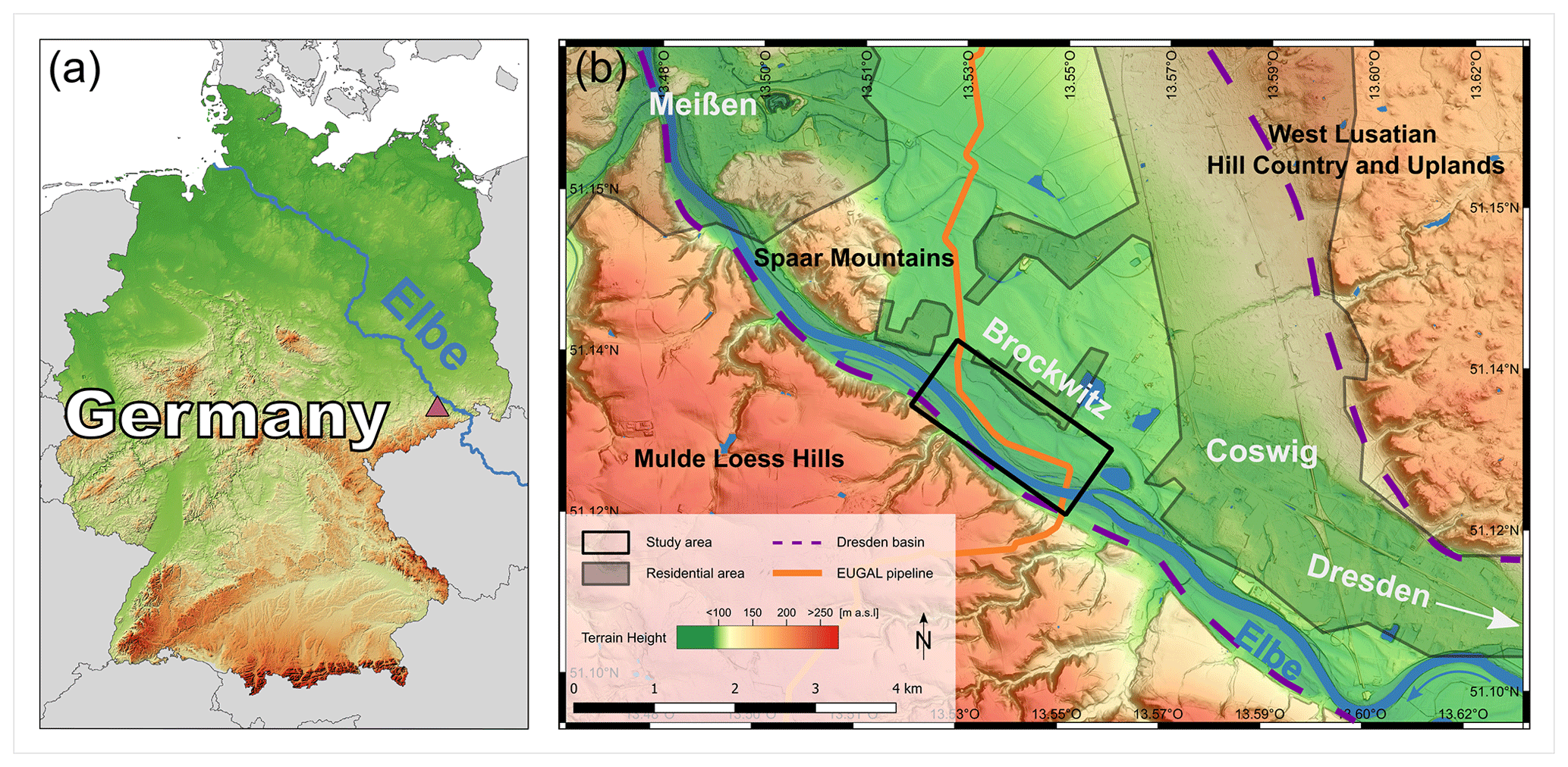
Figure 1(a) The location of the study site with the Elbe River course and (b) the EUGAL pipeline in the Elbe valley with the study site (© GeoBasis-DE/BKG 2020, DGM1-GeoSN, OpenStreetMap contributors 2020 under the Open Data Commons Open Database License (ODbL) v1.0).
Hence, this study aims to reconstruct the late Weichselian–Holocene evolution of the Elbe valley between the cities of Dresden and Meißen. This will allow for valid conclusions about former human occupation and its geomorphic–palaeoenvironmental context in the river valley and a comparison with the fluvial histories of other central European river systems. During our study we applied a comprehensive geoarchaeological approach that closely combined geoscientific methods with the archaeological excavations, an approach that is necessary to precisely study human–environmental interactions but that has been not very often systematically applied so far (von Suchodoletz et al., 2020). Our geoscientific set of methods encompassed stratigraphical, micromorphological, sedimentological–geochemical and archaeobotanical methods as well as radiocarbon and luminescence dating and enabled the analysis of the formerly and newly detected fluvial sediments and palaeosols and their precise relations with former human activities.
The study area is situated in the northwestern Dresden basin (“Dresdner Elbtalweitung”), between the cities of Coswig and Meißen on the right Elbe banks (Figs. 1 and 2). Here, the about 3–8 km wide Dresden basin is framed by the West Lusatian Hill Country and Uplands (“Westlausitzer Hügel- und Bergland”) granite massif to the east and northeast, the Mulde Loess Hills (“Mulde-Lösshügelland”) to the west and the hilly “Großenhainer Pflege” to the north (Mannsfeld and Bernhardt, 2008; Tinapp, 2022).
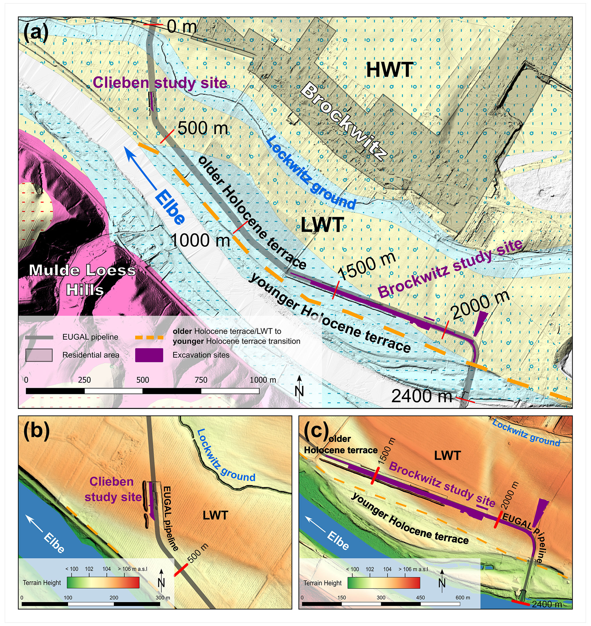
Figure 2(a) Detailed view of the study area around the EUGAL pipeline with close-ups on the (b) Clieben and (c) Brockwitz study sites (© DGM1-GeoSN, OpenStreetMap contributors 2020 under the Open Data Commons Open Database License (ODbL) v1.0: Geologische Karte der eiszeitlich bedeckten Gebiete Sachsen 1 : 50 000 – LfULG Sachsen).
Being one of central Europe's largest rivers (river length of 1094 km, catchment of 148 000 km2) (Pusch et al., 2009), the Elbe originates from the southern Giant Mountains (“Krkonoše”) in the Czech Republic at 1386 m a.s.l. From there, the upper Elbe flows in an arc through Bohemia, heads north and after crossing the German border passes over into the middle Elbe valley when entering the North German Plain north of the city of Meißen. Finally, the river meets the North Sea west of Hamburg (Hantke, 1993; Pusch et al., 2009).
Between the cities of Dresden and Meißen the Elbe valley's course has been predefined by the Variscan Elbe Fault System (EFS), one of the major crustal shear zones in Europe (Scheck et al., 2002). Up to 650 m of Cretaceous shallow marine and alluvial sand- and limestone reflect a manifold landscape history in and around this sedimentary basin (Tröger 2008). Simultaneously to the formation of the North Atlantic, the EFS shear zone reactivated during a late Cretaceous–early Cenozoic compression phase, when western Lusatia was moved southwestwards and thrusted over the EFS and its Cretaceous sediments (Krentz, 2008).
Until the Pliocene, a levelled landscape with shallow river valleys and a higher altitude than the current highlands had established. Throughout the Quaternary strong fluvial incision took place, resulting in the formation of multiple sets of river terraces (Wolf et al., 2008). In the study area, the current Elbe valley was initially used by several smaller streams, and only strong meltwater erosion caused by a lowered erosional base following the Elster 2 glaciation enabled the Elbe River to flow along its quasi-current course in the Dresden basin.
During the Drenthe stage of the Saalian glaciation the glaciers maximally advanced just south of the city of Meißen (Eissmann, 2002). Subsequently, up to 20 m thick sands were deposited in the Elbe valley by melting water. During the following Warthe stage strong river erosion occurred, forming several deep channels southeast of the Spaar Mountains, which represent the Quaternary base in this part of the Elbe valley (Huhle, 2015) (Fig. 1b).
During the Weichselian glaciation, a gravely Higher Weichselian Terrace (HWT) and Lower Weichselian Terrace (LWT) were aggraded under periglacial conditions (Wolf et al., 1994; Eissmann, 2002). Most likely during the Last Glacial Maximum were the gravely LWT sediments subsequently covered by a so-called valley loam (Tallehm; Alexowsky, 2005). Due to erosional processes during the Weichselian deglaciation, full LWT sequences including the covering valley loam are only rarely preserved (Eissmann, 1997).
During the Late Pleistocene and Holocene two additional fluvial terraces were aggraded (Wolf et al., 2008). The older and morphologically higher terrace is dated from the Late Pleistocene to Middle Holocene (Wolf et al., 1994, 2008), and the younger one had formed since the late Subboreal (Wolf et al., 2008; Lange et al., 2016). Holocene overbank fines cover both Holocene terraces and the LWT.
The Elbe valley between the cities of Dresden and Meißen has been occupied by sedentary humans for the last ca. 7500 years (Brestrich, 1998; Stäuble, 2010, 2016). Accordingly, during archaeological excavations in 2009 and 2018/19 at our Clieben study site, features of an early Neolithic village were discovered within the valley loam in the uppermost part of the LWT fines that was covered by younger overbank fines (Fig. 4; Steinmann, 2010; Kreienbrink et al., 2020; Kreienbrink, 2022). Here, about 10 LPC (Linear Pottery culture) houses were detected, and a large-scale geophysical survey gave evidence that these belong to a major early Neolithic settlement. Also a few late Bronze Age features were found between the early Neolithic pits on the same stratigraphical level (Kreienbrink, 2022).
Further to the south, at our Brockwitz study site, early Mesolithic, early and middle Neolithic, early and late Bronze Age, Iron Age, and medieval Slavic archaeological remains have been uncovered at different levels within different deposits during archaeological excavations in 2009 and 2018/19 (Steinmann, 2010; Kreienbrink et al., 2020; Döhlert-Albani et al., 2022). Most sites were situated on the LWT, and only early medieval Slavic features were predominantly situated on the older Holocene terrace (Tinapp et al., 2022).
3.1 Fieldwork
Parallel to the EUGAL pipeline construction in 2019, a 2400 m long stretch of the pipe trench with a depth of about 3 m, locally 6 m, has been examined. As a result, 42 profiles were logged, and the strata's courses were recorded and paralleled. The distinct strata were characterized in the field for grain size; sediment/soil colour; humus and moisture content; and pedogenetic and further features such as archaeological finds, plant material, sediment features or anomalies. Furthermore, plant and/or wood material was taken for radiocarbon dating.
At the Clieben and Brockwitz study sites profiles have been recorded in detail during the excavations. Their description followed the FAO (Food and Agriculture Organization of the United Nations) classification (IUSS Working Group WRB, 2014; soil colour was determined using the Munsell soil colour chart). Furthermore, samples were taken for sedimentological, micromorphological and palaeoecological analyses, as well as for optically stimulated luminescence (OSL) dating.
3.2 Sedimentological analyses
-
First, bulk sediment samples were air-dried and sieved to obtain the fine fraction of <2 mm that was used for the analyses. A portion of this material was subsequently ground in a planetary ball mill (PM 200) for 10 min to obtain a grain size of <30 µm that is needed for X-ray fluorescence (XRF) and elemental analysis (CNS). Grain-size analyses were conducted on organic-free (pretreated with 35 % H2O2) material. The sand fraction was analysed by sieve analysis, and the clay silt fraction was analysed by X-ray granulometry (XRG; Micromeritics SediGraph III 5120).
-
pH values were measured in a 0.01 M CaCl2 suspension following DIN ISO 10390 with a ratio of 1:2.5 (soil / water).
-
Carbonate contents were measured with the volumetric method referring to Scheibler by using an Eijkelkamp calcimeter.
-
Total organic carbon (TOC) was determined by measuring Ctotal with a vario EL cube elemental analyser (Elementar) and subsequently subtracting inorganic carbon (taken from the carbonate measurements) from Ctotal. Total nitrogen and sulfur contents were measured with the vario EL cube elemental analyser in parallel with Ctotal.
-
Element concentrations were measured using non-destructive X-ray fluorescence spectrometry (XRF). For this purpose, bulk samples were mixed with a wax binder (CEREOX Licowax) and pressed into 32 mm pellets. The measurements were performed with an energy-dispersive polarization XRF (EDPXRF) SPECTRO XEPOS (SPECTRO Analytical Instruments Ltd.) analyser in a helium gas atmosphere. All elements from Na to U were determined simultaneously and adjusted to the sample weight.
Pedogenesis depends not only on the properties of the parent material, the climatic conditions and human activity but also significantly on time. Weathering indices are multicomponent ratios of lithogeochemical compositional element and are commonly used to estimate weathering intensity, since they depict structural and mineralogical changes of the sediments during weathering. Over the past decades, very different indices and element ratios have been developed for different sediments in various climates (Pandarinath, 2022). Generally, the applied ratios usually expressed as oxidic proportions in moles determined by means of XRF are included in the calculation. Ideally, the applied ratios should only have been altered by pedogenetic processes.
During weathering, soluble cations with a low ion potential of <3 (e.g. K+, Na+, Ca2+, Mg2+) are washed out relatively easily, whereas e.g. Al3+ with a high ion potential of 5.9 is bound in clay minerals and forms relatively insoluble hydroxides between a pH value of 4 and 10. Thus, the Al2O3 content changes very little during weathering and can hence be assumed to be constant (Bowen, 1979; Kausch, 2009). Consequently we selected the weathering index (VWI, visual weathering index) of Birkeland (1999), whereof low ratios indicate intensive weathering:
In general, ion mobility decreases and the tendency of adsorption to fine-grain sediment or soil particles increases with a rising ion radius (Smykatz-Kloss et al., 2004). Hence, the larger Rb+ ion is better adsorbed compared with the smaller K+ ion so that the ratio normally decreases during in situ soil formation. However, it is also assumed that high values in loess/palaeosol sequences could also reflect secondary potassium enrichment, possibly caused by clay accumulation due to the input of preweathered material (Fischer et al., 2012).
Also the ratios and can be interpreted using differences in ionic radii. The respective smaller ions in the denominator (Sr and Na+) are more easily discharged as a result of weathering than the larger ions in the numerator (Rb+ and K+). Hence, high ratios represent strong weathering (Smykatz-Kloss, 2003; Reitner and Ottner, 2011).
3.3 Numerical dating
Luminescence (OSL) dating
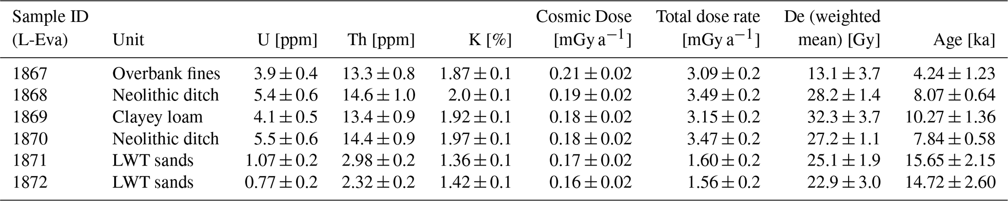
Six luminescence samples were taken at the Brockwitz study site using light-tight steel tubes, which were hammered into the freshly cleaned outcrop walls (for sampling positions, see Fig. 7).
Preparation of the coarse-grain quartz fraction (180–250 µm) was done under subdued red light in the Department of Human Evolution, Max Planck Institute for Evolutionary Anthropology (Leipzig). Sample preparation started with drying and sieving, and subsequent chemical preparation included a treatment with 10 % HCl and 30 % H2O2 to remove carbonates and organic material, respectively. Following this, quartz was separated from the other mineral fractions by density separation using sodium polytungstate solutions (2.62 and 2.70 g cm−3). Finally, the quartz-rich material was etched with 40 % hydrofluoric acid (HF) for 60 min and subsequently resieved.
Equivalent dose (De) measurements using a single-grain regeneration (SAR) approach (Murray and Wintle, 2003) were performed on a Risø TL/OSL (thermoluminescence) DA-20 reader equipped with blue and IR-emitting diodes. The blue stimulated quartz signal was measured at 125 ∘C for 40 s, and the 340 nm emission was filtered through a Hoya U340 filter. Irradiation was conducted with a calibrated beta source (dose rate of 0.1 Gy s−1). The preheat and cutheat temperatures were set to 170 ∘C, respectively, as this combination yielded satisfying results of the dose recovery test with a ratio of the measured to the given dose of 1.08±0.09.
Between 24 and 48 aliquots with 2 mm size were measured of each sample. This aliquot size was chosen to obtain a sufficient high signal-to-noise ratio. The dose response curve was built with four regenerative doses, and for a quality check IR depletion and recycling ratios were determined. For final De estimation, only aliquots with deviations of <20 % from unity (IR depletion and recycling ratio) were accepted.
Material for dosimetry was taken from the sampling spots and their nearby surroundings. Concentrations of the radioactive elements U, Th and K were determined using high-resolution gamma spectrometry at the Felsenkeller laboratory (VKTA) in Dresden, Germany, using a N-type detector.
Radiocarbon dating
Five radiocarbon samples were analysed in the Curt-Engelhorn-Zentrum Archäometrie in Mannheim (CEZ) using accelerator mass spectrometry (AMS) radiocarbon dating and were calibrated using IntCal20 and SwissCal 1.0.
3.4 Micromorphology
Micromorphological samples were taken from the Brockwitz study site in 2018 to characterize the different sediment layers and soil horizons. Thin sections were prepared from oriented and undisturbed blocks that were impregnated with resin. The thin sections were analysed using a petrographic microscope under plane-polarized light (ppl), cross-polarized light (xpl) and oblique incident light (oil). The microscopic description mainly followed the terminology after Bullock et al. (1985) and Stoops (2003).
3.5 Palaeobotanical analyses
Plant macroremains were extracted by flotation and wet sieving (mesh widths of 2, 0.5 and 0.25 mm) and determined under magnification from 6.3× to 40× using standard literature (e.g. Cappers et al., 2012) and the reference collection at the Laboratory of Archaeobotany, Institute of Prehistoric Archaeology, Goethe University. Attribution of the taxa to ecological units followed Oberdorfer (2001).

Figure 3Several locations along the pipeline trench. (a) West-oriented profile in the Lockwitz ground, exposing peat covered by overbank fines surrounded by fluvial channel sediments (at 35 m). (b) South-oriented profile exposing LWT gravels with valley loam and Holocene overbank fines (at 350 m). (c) West-oriented profile south of the Clieben study site, exposing a palaeochannel at the transition of the LWT to the older Holocene terrace (at 430 m). (d) Southeast-oriented profile showing sediments of the older Holocene terrace with a palaeochannel and overlying overbank fines (at 870 m). (e) Southeast-oriented profile exposing clayey loam with a humic topsoil and arising LWT sediments in the background (at 1780 m).
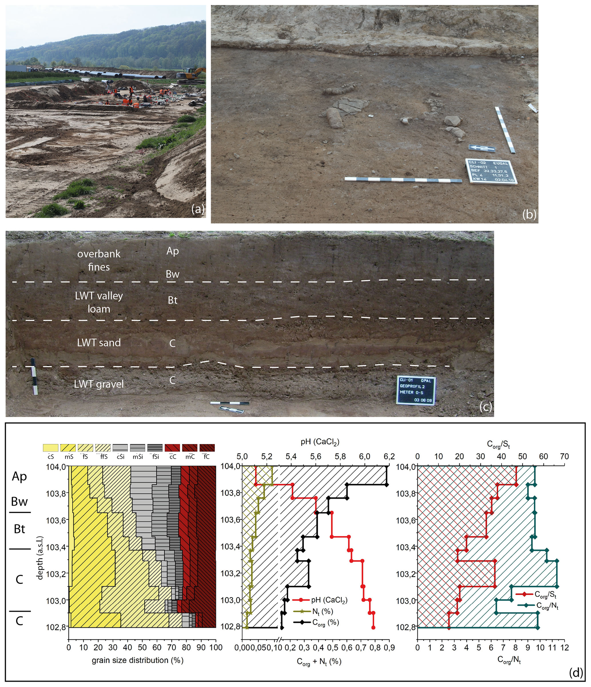
Figure 4Clieben study site. (a) Overview of the archaeological excavations in 2019. (b) A section of the Neolithic surface with a broken rubbing stone. (c) Photo of profile 2 documented in 2008: the uppermost part of the LWT is formed by a valley loam that is covered by younger Holocene overbank fines. (d) Analytical values of profile 2 with particle size distribution and pH values, as well as organic carbon, sulfur and nitrogen contents and ratios.
Table 1Stratigraphical positions (also see Fig. 7), dosimetric data, equivalent doses (De) and quartz OSL ages of the luminescence samples taken from profile 17 at the Brockwitz study site. The De values are based on the weighted mean of all accepted single De's.
The pipe trench and especially the uncovered sediments and soils at the two study sites during the excavations (Clieben and Brockwitz) allowed for detailed examinations of the late Weichselian and Holocene deposits in the Elbe valley.
4.1 Trench
Based on the examination of about 2.4 km of the EUGAL pipeline trench, several distinct sedimentary units could be identified. However, due to time and security constraints during pipeline construction, sediment description and sampling could not always be carried out at the same qualitative level along the trench.
4.1.1 LWT
LWT sediments were mainly found in two areas along the trench: in the northwestern part of the Clieben study site (Fig. 2, 150–420 m) and the southeastern part of the Brockwitz study site (Fig. 2, 2075–2175 m). LWT sandy gravels were superimposed by valley loam, which was covered by Holocene overbank fines (Fig. 3b). Remains of an early Neolithic settlement and linked archaeological findings at the Clieben study site stratigraphically reach from the surface of the valley loam into the underlying gravels and sands (Fig. 4). The terrain rises to >104 m a.s.l. in the former settlement area at the Clieben study site (at 340 m), roughly 1 m higher compared with the surroundings (Fig. 2b). Similarly, in the southeastern part of the Brockwitz study site, a terrain height of 105 m a.s.l. (at ∼2125 m) after a steady ascent to the southeast marks a local maximum that surpasses its surrounding terrain height by ca. 1 m (Fig. 2c).
4.1.2 LWT and clayey loam
Along approximately 500 m of the pipe trench (1575–2075 m), i.e. a major part of the Brockwitz study site, a sequence of basal LWT gravely sands were cropped out. Upwards, these concordantly pass over into a 1–2 m thick layer of clayey loam that is overlain by Holocene overbank fines (Fig. 3e). OSL dating indicates a late Weichselian formation of the upper LWT deposits around 15 ka (Table 1, Fig. 7). In agreement with the OSL ages, an early Mesolithic camp site (at 1870 m) at the base of the clayey loam indicates a predominantly early Holocene deposition of the clayey loam. To the southeastern part of the Brockwitz study site, the clayey loam crosses out in gradually arising LWT sediments (at 2075 m).
One distinct palaeochannel was discovered in this part of the pipe trench (at 1950 m), cutting the clayey loam and the underlying LWT sands and gravels. The channel filling was similar to the clayey loam. These sediments are covered by older and younger Holocene overbank fines that are separated from each other by another palaeosol.
4.1.3 Holocene sediments
Gravely and sandy sediments of the older Holocene terrace with overlying overbank fines dominated the pipe trench for approximately 1.1 km between the Clieben and Brockwitz study sites (Fig. 3d, 420–1525 m). The base of the older Holocene terrace was formed by an about 1 m thick layer of gravely sands with some loamy strata showing a general decrease in gravels upwards. These were covered by ca. 2.5 m sandy overbank fines with a fining-upward trend. Here, strata thicknesses vary widely along the trench. Repeatedly, the base of the overbank fines reached deeper than the pipe trench, implying a vertical extension of >4 m at these sections. Wood samples were taken from an oak tree that was found at the transition from the terrace gravels to the overlying overbank fines (635 m), which were 4.3 m thick at this particular location. Radiocarbon dating of this material gave a terminus post quem for the onset of the fine overbank sedimentation between 3962 and 3802 BCE (MAMS-45651, Table 2). Partly observed palaeosols divide the overbank into an older and younger sedimentation phase.
South of the Brockwitz study site (at 2240 m) the transition of the LWT with its covering overbank fines towards the current Elbe floodplain is marked by a ca. 2 m drop in terrain height. Within the latter the stratigraphy is dominated by sands and gravels of the younger Holocene terrace with covering younger Holocene overbank fines. With closer proximity to the river, the overbank fines' thickness gradually decreases. Additionally, a former river island with a thick gravel body, surpassing its vicinity by ca. 1 m, was observed close to the current bank of the Elbe River between 2300 and 2350 m (Fig. 2).
4.1.4 Holocene channels
The northwesternmost section of the pipe trench was dominated by non-LWT gravely sands. These stretched for approximately 150 m southward along the trench and subsequently thinned out into LWT sediments north of the Clieben study site around 150 m. Within these non-LWT gravely sands, an up to 3.3 m thick trough-shaped layer of dark-brown organic sediments with plant remains such as roots and stalks was embedded, showing a maximum lateral extent of ca. 25 m (Fig. 3a). Archaeobotanical analyses of the excavated organic material from the profile base classified these as sedge peat derived from a large variety of plant taxa, giving insight into the former local vegetation during the Boreal. The sedge peat/reed is represented by Carex spp., Alisma plantago-aquatica agg., Lycopus europaeus, Scirpus lacustris, Typha or Oenanthe aquatica, and several taxa suggest nutrient-rich conditions with a herbaceous vegetation in some parts of the banks (Rumex maritimus, Ranunculus sceleratus, Polygonum lapathifolium, Polygonum minus and Chenopodium polyspermum). Remains of Betula pendula, Quercus, Polygonum dumetorum, Thalictrum flavum and Urtica dioica mirror the adjacent alluvial forest, whereas aquatic plants such as Nymphaea alba or Ceratophyllum demersum show a standing waterbody without strong currents or waves.
The archaeobotanical analyses of the overlying layers dating to the Atlantic period merely confirmed the Boreal taxa spectrum with only minor alterations. The more abundant annuals Atriplex and Chenopodium album could have been distributed along the riverbanks or hint to nearby human activities. Especially seeds of the bladder cherry Physalis alkekengi are of special interest, since its natural distribution is on riverbanks in southeastern Europe. Hence, it must have been brought to the study area most probably with LPC settlers as a cultivated plant (Herbig 2012, p. 153).
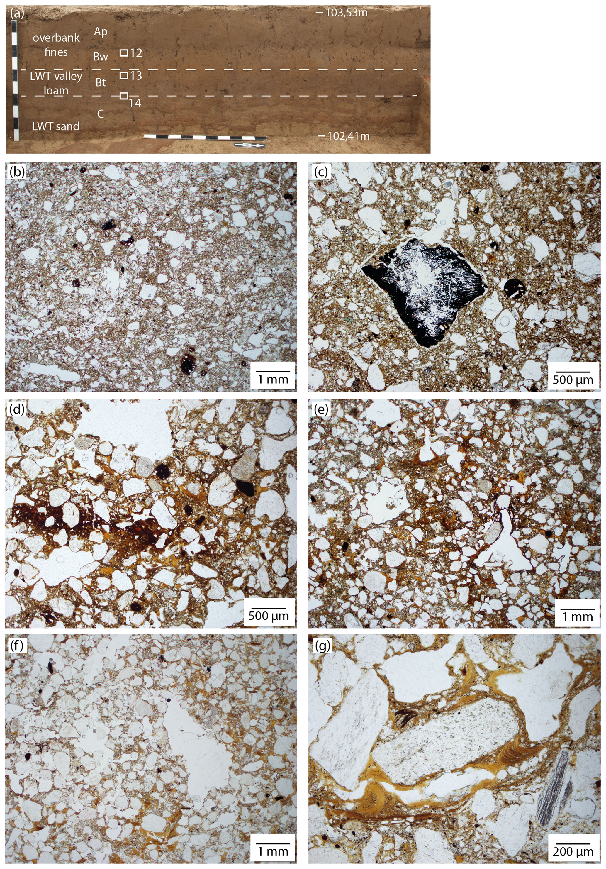
Figure 5Clieben study site. (a) Photo of profile 3 which was studied in 2019 with locations of the thin-section samples (12: overbank fines, 13: LWT valley loam, 14: transition LWT valley loam to LWT sands). Microphotos of the thin sections (all in ppl): (b) sandy and silty overbank fines with disorthic iron oxide nodules, (c) overbank fines with charcoal pieces, (d) valley loam with disorthic iron oxide nodules and matrix impregnation, (e) valley loam with clay infillings and coatings of voids, (f) sandy material of the LWT, and (g) LWT material with clay infillings and coating of a void.
The radiocarbon ages of three peat samples were 7776–7595 BCE (MAMS-44467), 6742–6573 BCE (MAMS-47072) and 3961–3800 BCE (MAMS-47071) (see Table 2). Hence, peat formation extended from the Boreal until the Atlantic period. Subsequently, the peat was covered by about 3 m thick overbank fines (loamy sands), into which the bed of the “Lockwitzbach” current creek is embedded.
Within an eastward bend of the trench south of the Clieben study site (Fig. 3c), the terrain height suddenly drops by about 1 m. Here, a diagonal, ca. 25 m wide palaeochannel marks the transition between the LWT to the north and the older Holocene terrace to the south and southeast (Fig. 2a). At the trench base at ca. 3 m depth, the channel is filled with organic-rich loamy sands, which contained one oak tree trunk. This oak tree has been radiocarbon-dated to 3773–3649 BCE (MAMS-44468, Table 2), i.e. to the late Atlantic period. The loamy sands are superimposed by grey sands, then followed by a fining-upward loam layer with a thickness of ca. 1 m that contained small proportions of sand and charcoal. The top of the profile was formed by 1.9 m thick clayey overbank fines (Fig. 3c). In addition to this a palaeochannel, three further palaeochannels with equal or smaller dimensions and similar sedimentary fillings were observed that were also incised into the sediments of the older Holocene terrace.
4.2 Clieben study site
Post holes and pits found between 0.5 and 1 m below the surface after removal of the covering overbank fines prove an early Neolithic settlement on the LWT (Fig. 4a and b; Steinmann, 2010; Kreienbrink, 2022). Furthermore also some features originating from the late Bronze Age were recorded on the same level. The northern boundary of the settlement is represented by the remnants of an old channel used by a small creek (Lockwitzbach) in recent times (Figs. 2 and 3a). In the south, the LWT is limited by the older Holocene terrace.
In the central part of the early Neolithic settlement the stratigraphical base is formed by LWT sands that merge upwards into the valley loam without clear boundaries (Fig. 4c). Soil development – weathering and lessivage – overprinted these Weichselian sediments. The Neolithic surface is found at an altitude of 103.6 m a.s.l. on the topographically highest part of the valley loam, and the LWT including the archaeological surface is covered by younger Holocene overbank fines. The latter consist of brown loamy sands that contain charcoal, fired clay and younger potsherds.
According to the analytical values of profile 2, the valley loam contains ∼0.3 % organic carbon, and the highest values of 0.9 % are found in the recent plough horizon (Ap) at the top of the overbank fines. However, the Neolithic surface with archaeological features and findings (upper part of the Bt horizon) does not show a peak of organic carbon. This is consistent with nearly the same colour of the valley loam and the Holocene overbank fines (dark yellowish brown, 10YR4/4).
The micromorphological analyses of samples taken from profile 3 prove that the upper overbank fines contain disorthic (reworked) iron oxide nodules and charcoal pieces (Fig. 5b, c).
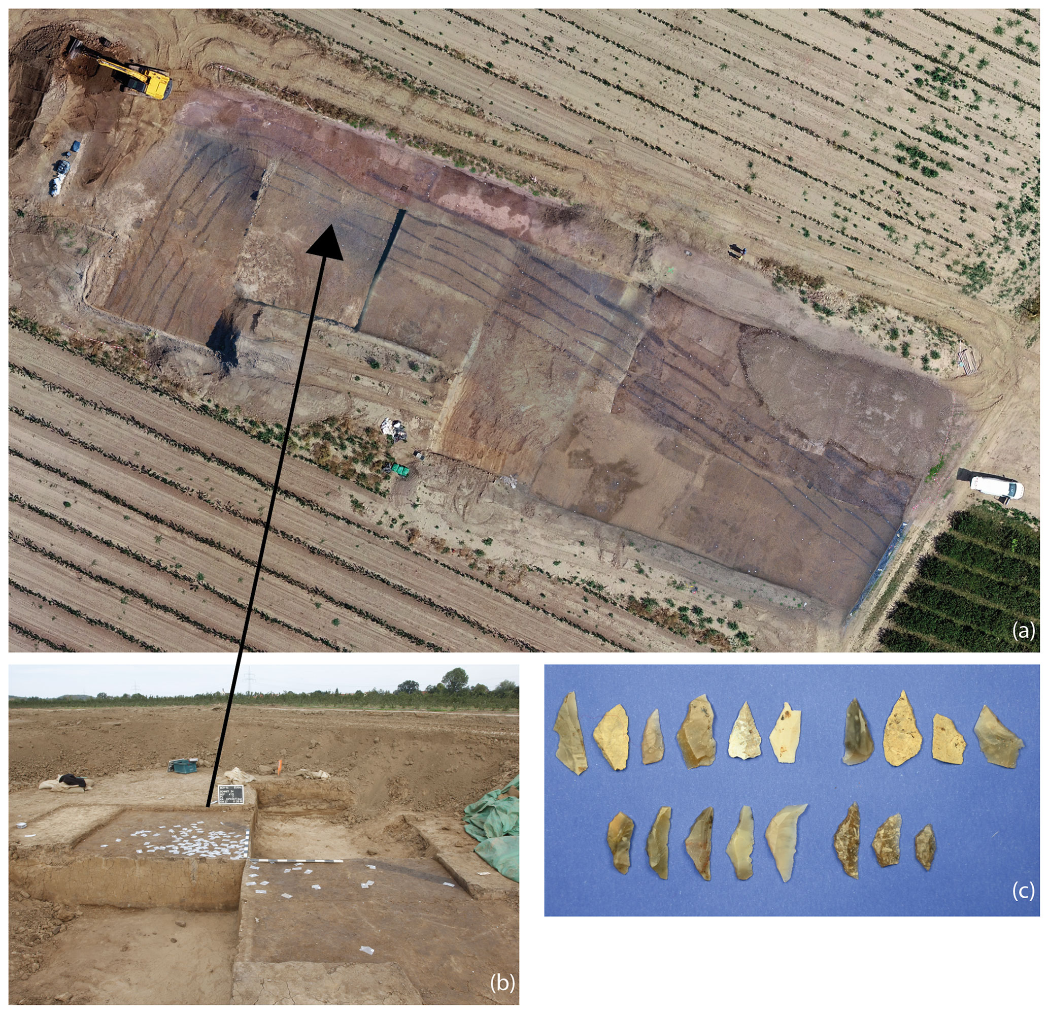
Figure 6Brockwitz study site. (a) Aerial photo of the archaeological excavation with the Neolithic palisade in 2018 (1850–1940 m). (b) The early Mesolithic chipping floor during excavations. (c) Microliths (at 1870 m).
Pedogenic transformation of the Holocene overbank fines is rather weak, as only few small clay infillings and coatings of voids could be detected. Also the underlying Weichselian valley loam contains reworked iron oxides (disorthic nodules). In addition, in situ formed ferruginous matrix impregnations and an increasing number of clay coatings and infillings (Fig. 5d, e) are detectable in the valley loam. The latter features are undisturbed, indicating a stable period of postsedimentary soil formation during the late Weichselian to Holocene. The transition to the underlying LWT sands is clear, and these show downwards decreasing features of soil formation with the exception of clay illuviation features like infillings and coatings of voids that were even found in greater profile depth (Fig. 5f, g).
4.3 Brockwitz study site
The geological structure at the Brockwitz study site is less homogeneous compared to Clieben. A small area in the southeastern part belongs to the topographically highest peaks of the LWT, showing heights around 105 m a.s.l. (2075–2175 m). Here, some late Bronze Age features were dug into the valley loam and the underlying gravels and sands, and overbank fines are missing here. Compared to the elevated terrain in the southeast, the height of the remaining LWT surface is 1–3 m lower in most other parts of the study site. However, nowadays this altitudinal difference is levelled by Holocene overbank fines. Several sediment profiles were recorded here, and a combined sampling approach was applied to the sediments, soils and Neolithic features of profile 17 (Figs. 6, 7).
The base of that profile is formed by LWT sands that were dated by OSL to around 15 ka (Table 1, Fig. 7) and show only minor pedogenetic features. Thin sections show that parts of the sands are free of finer components, while clay illuviation, bridging the individual grains, is visible in other parts (Fig. 8e, f). Upwards the sands merge into clayey loam with up to 1 m thickness. Soil development overprinted parts of the latter material, and a 0.4 m thick Ahb horizon had established at its surface. The OSL date from the lowest part of the clayey loam shows an early Holocene age of 10.27 ± 1.36 ka (Table 1). In this layer clay percentages reach > 40 %, while sand remains around 20 %. Micromorphological samples were taken from both the undisturbed clayey loam and a Neolithic ditch filled with relocated clayey loam. The infilling is dark greyish brown and thus seems to be rich in organic matter and contains numerous undisturbed clay infillings and coatings of voids (Fig. 8b–d). Charcoal pieces prove anthropogenic activities (Fig. 8c). Deep cracks in the Ahb horizon caused by shrinking of the clayey material were filled with brown-coloured, younger overbank fines. Also macroscopic analysis shows strong aggregation features, while under the microscope vertic properties such as slickensides are absent. Despite the dark colour of the Ahb horizon (very dark greyish brown, 10YR3/2) organic carbon values reach only 0.6 % (Fig. 7).
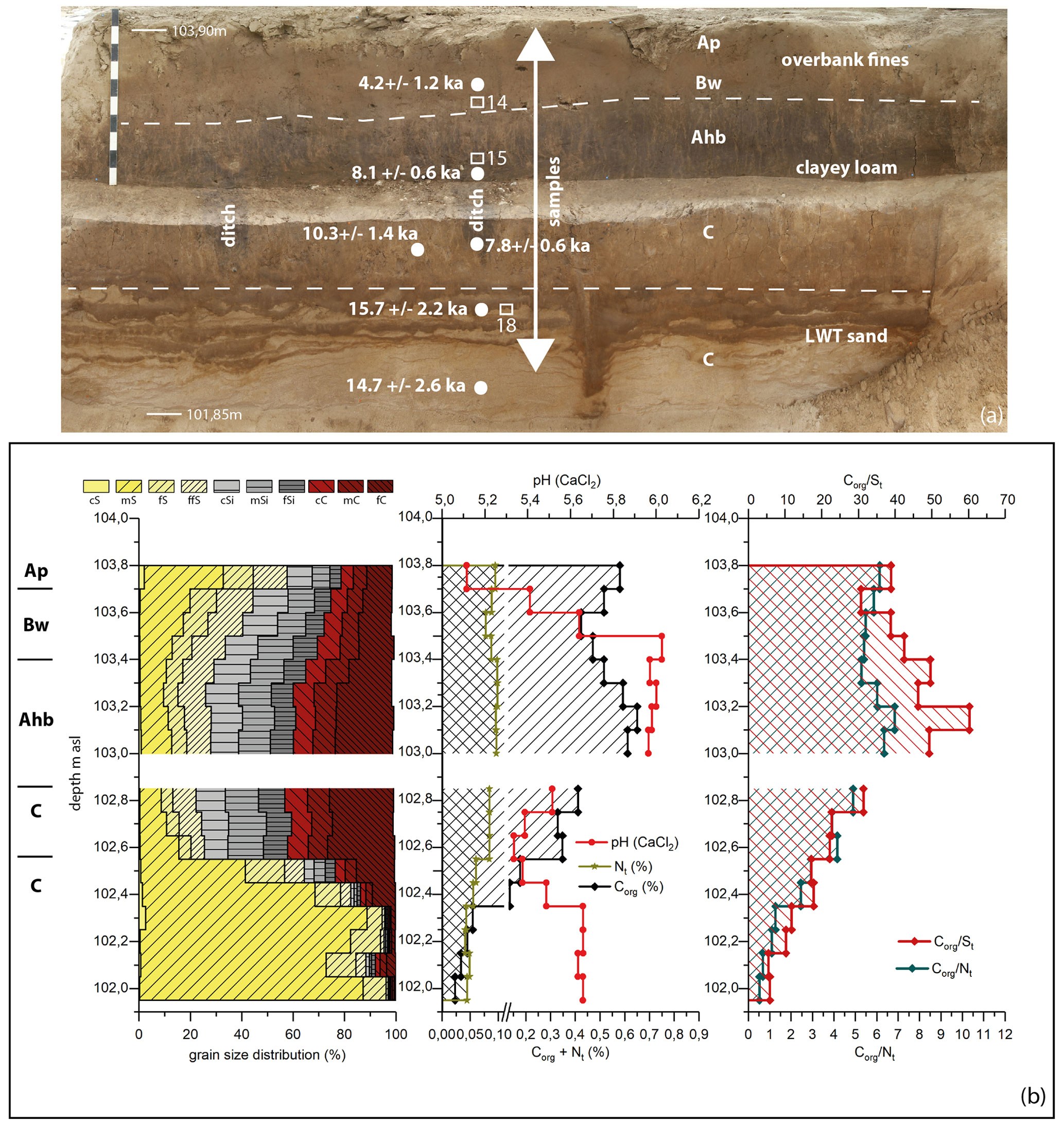
Figure 7Brockwitz study site. (a) Photo of profile 17 (at 1860 m) that was studied in 2018 with two ditches from the Neolithic palisade, OSL ages and the positions of micromorphological samples (14: overbank fines, 15: clayey loam/Neolithic ditch, 18: LWT sands). (b) Analytical values of this profile with the particle size distribution and pH values, as well as organic carbon, sulfur and nitrogen contents and ratios.
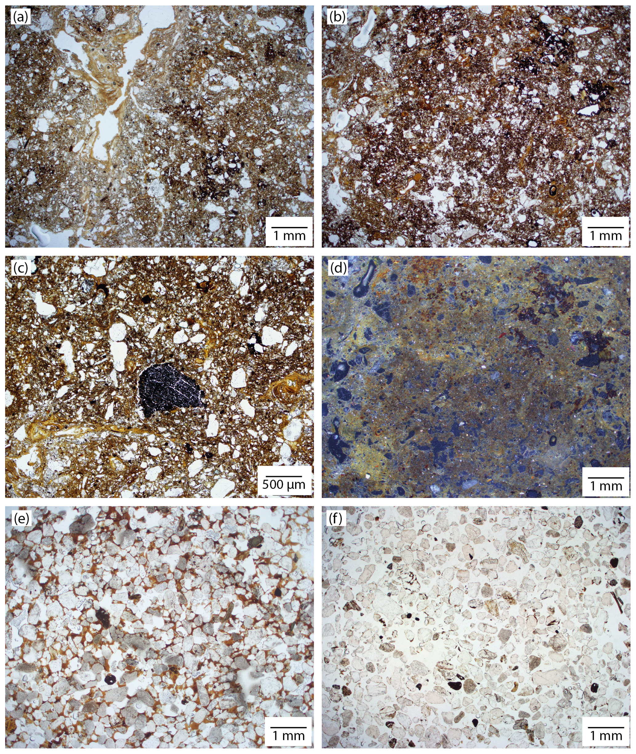
Figure 8Brockwitz study site. Microphotos of profile 17 (A–C and E–F in ppl, D in oil). Sample 14 (overbank fines): (a) loamy cover sediment with iron oxides and clay coating of a void. Sample 15 (clayey loam from Neolithic ditch): (b) clayey loam rich in clay infillings and coatings of voids, (c) clayey loam with charcoal pieces, and (d) dark greyish brown of the clayey loam due to organic matter. Sample 18 (LWT sands): (e) sandy material of the LWT with clay bridging the sand grains and (f) sandy material of the LWT without fines.
The small VWI ratios in the upper, clay-rich C horizon show obvious preweathering of the substrate (Fig. 9). This tendency becomes even clearer in the ratios. In the clay-rich Ahb and C horizons (103.4–102.55 m a.s.l.), the ratio is <400 and clearly demarcated from the other horizons, indicating in situ soil formation. Despite very high clay contents, it cannot be assumed that preweathered material was introduced.
The commonly used ratio is based on different ion radii, since the much smaller Sr2+ ion is more easily leached during weathering, whereas Rb is fixed to clay (McLennan et al., 1993; Reitner and Ottner, 2011). Hence, high ratios indicate intense weathering.
Similarly, due to partial adsorption of K+ on clay minerals and organic substances, less K+ is removed compared with the smaller Na+ ion during chemical weathering so that increasing ratios indicate chemical weathering (Smykatz-Kloss, 2003). When comparing the soluble alkali cations K+ and Na+, a clear enrichment of the larger and therefore less mobile K+ compared to the Na+ ion can be detected during soil formation. Although both cations are dissolved during chemical weathering, some of the K+ ions (radius of 138 pm) can subsequently be adsorbed again by fine-grain particles such as clay minerals or organic matter and thus be partially retained in the soil, while the smaller Na+ ion (102 pm) is discharged into the soil solution. Given that both the and ratio are increased in the Ahb and C horizon, this clearly indicates their intensive weathering.
Just a few centimetres above the base of the clayey loam, an early Mesolithic campsite for hafting and retooling was discovered and excavated near profile 17 (Fig. 6). It consists of silex artefacts, destroyed by fire; quartzite pebbles; and pieces of burnt animal bone (Fischer in Döhlert-Albani et al., 2022). This demonstrates short human activity during the middle Preboreal causing the accumulation of a great number of artefacts and leftovers from meals (Fig. 6). Afterwards, clay-rich overbank sedimentation covered these artefacts relatively contemporaneously largely without replacing them, since >50 % of the silex inventory are chips of <1 cm in length. The next verified human activities took place during the early and middle Neolithic leaving many pits, with up to six parallel ditches belonging to former palisades (Figs. 6, 7). Two OSL samples taken from the archaeosediments in one of these ditches gave early Neolithic ages of 7.8 ± 0.6 and 8.1 ± 0.6 ka (Table 1). Despite these numerical ages, a younger age (middle Neolithic: 6.4–4.8 ka; Miera et al., 2022) is assumed here for archaeological reasons; i.e. the luminescence ages must be overestimated (Stäuble et al., 2022). Later, these archaeosediments and the overprinting Ahb soil horizon were covered by younger overbank fines. The latter deposition started at the end of the Neolithic or the beginning of the Bronze Age during the Subboreal period, which is proved by the OSL age of 4.2±1.2 ka and archaeological features of the late Bronze Age, which were partly dug into these younger overbank fines.
The younger overbank fines covering the clayey loam are more sandy and less clayey compared with the latter. Similar to the overbank fines in Clieben, their colour is dark yellowish brown (10YR4/4) and they contain charcoal pieces and reworked iron oxides (Fig. 8a).
5.1 Late Weichselian–Holocene transition
During the late Weichselian cold period, the LWT showed a surface with a diverse morphology (Fig. 10): around 15 ka older gravels, supposedly deposited between the Denekamp Interstadial and the Last Glacial Maximum (LGM) (30 000–20 000 ka) (Alexowsky, 2005; Litt et al., 2007), nearly reached an altitude of 105 m a.s.l., while sands were deposited in a 3 m deep channel at the Brockwitz study site. During that time the large gravel plain of the LWT, belonging to the braided Elbe River system (Kaiser et al., 2012), was dissected by several shallowly incised channels. Subsequently, fluvial sands were deposited during the initial warmer phases of the final glacial period. The channels on the LWT had been preserved and remained visible until the transition to the Holocene, quite similar to other late Weichselian terraces of the Rhine River or Danube River systems (Schirmer, 1995; Schellmann, 2018).
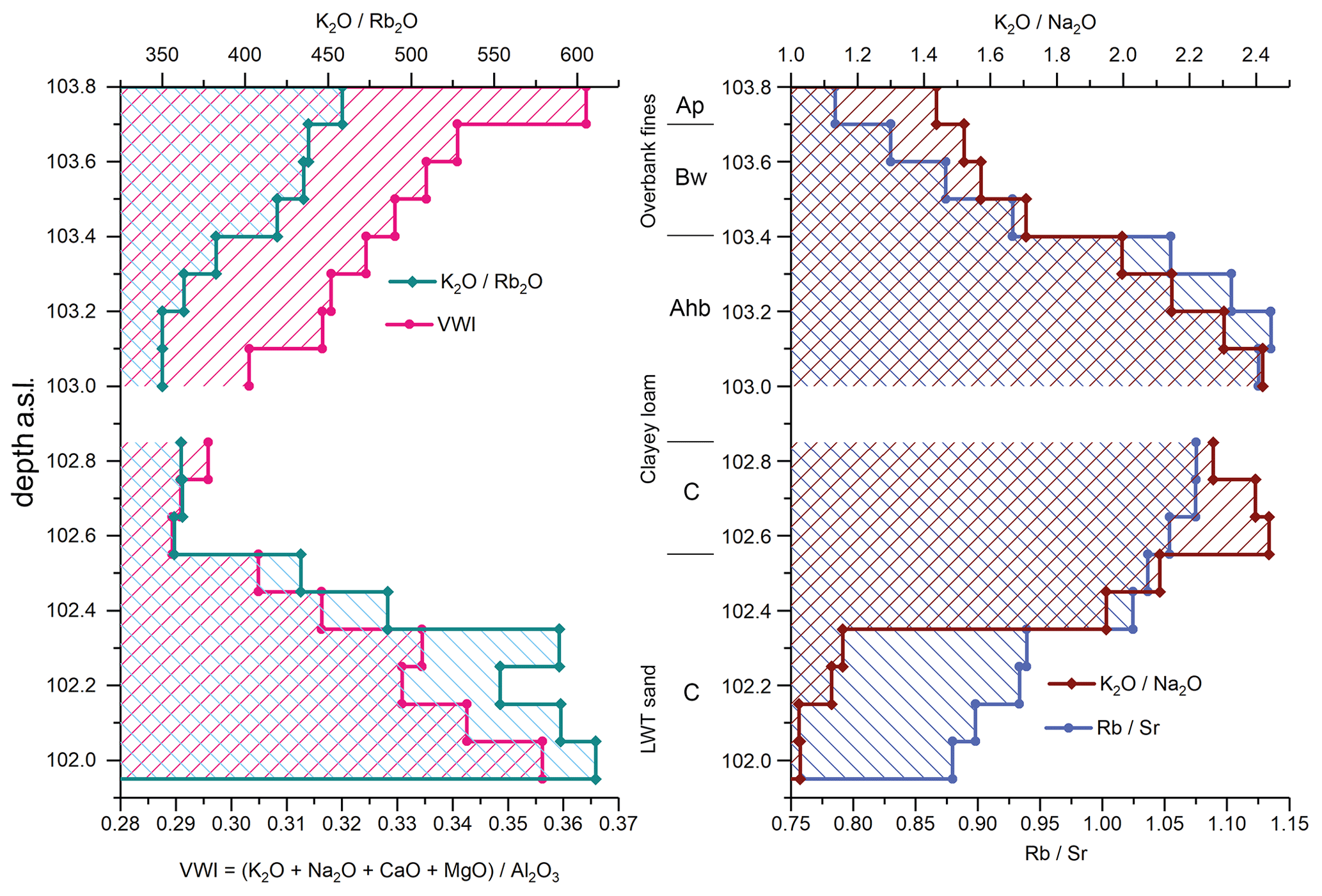
Figure 9Brockwitz study site. Profile 17 with the alteration index (VWI) and the element ratios of K2O, Rb2O Sr and K2O Na2O.
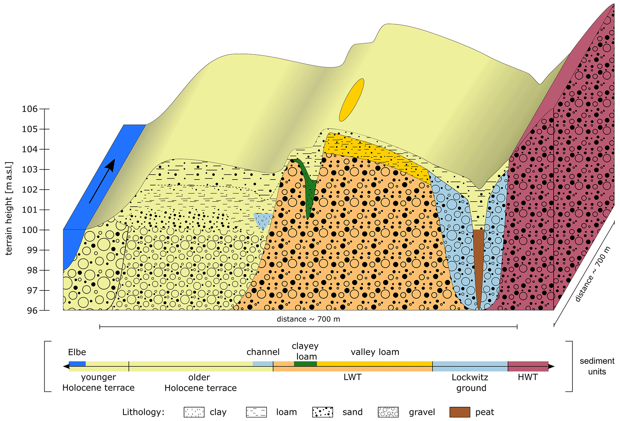
Figure 10Schematic transect through the right bank of the Elbe valley in the study area in the northwestern Dresden basin between the Spaar Mountains and the city of Coswig, south of Meißen (see Fig. 1b for the location). HWT: Higher Weichselian Terrace, LWT: Lower Weichselian Terrace.
Sedimentation and erosion in the study area and especially during the formation of the LWT were closely connected to the larger-scale development of the Elbe River system. Seemingly, intense incision occurred in the central European river systems during the Early Holocene. However, in the Elbe valley this switch apparently occurred later (Brose and Präger, 1983) compared with other central European river systems (Kaiser et al., 2012). Here, a late Weichselian–Early Holocene anastomosing channel pattern is assumed. During that time the “Lockwitz ground” at the northern valley margin of our study area also formed part of the Elbe floodplain (Figs. 2, 3a). According to our 14C dates, this channel was abandoned only after a middle–late Preboreal incision phase of the Elbe system, and its organic sediments demonstrate boggy conditions from the Boreal until the Atlantic period. Here, the location of the channel near the transition to the HWT intensified water influx, supporting organic-rich sedimentation regardless of the deep incision of the main Elbe channel. Hence, the location of the Lockwitz ground at the transition from the LWT towards the HWT defines it as a seam channel (Nahtrinne). This channel type marks the border between different terraces and hence aids as their distinction and was described e.g. at the Rhine, Main and Danube terraces (Schirmer, 1995; Schellmann, 2018).
The clayey loam was deposited in abandoned channels on the LWT during the Early Holocene. Whereas the covering younger Late Holocene overbank sediments were explained by increasing river discharge caused by anthropogenic impact on the catchment, the cause of the deposition of these Early Holocene deposits has not been addressed so far. Similar observations were reported from the lower Weser valley (Schellmann, 1994; Schirmer, 1995). It is located in the low mountain ranges of southern northern Germany, i.e. some kilometres south of the North German Plain. There, a dark soil (Feuchtschwarzerde) had developed in overbank fines, which were deposited in palaeochannels (Aurinnen) incised in Weichselian gravels. According to Schellmann (1994) these soils had developed in the Allerød period as well as in the Early Holocene. Similar conditions are also found for the Elbe valley between Dresden and Riesa. Here the valley bottom still consists of Palaeozoic rocks, whereas in the North German Plain near Riesa some kilometres to the north, glacial sediments dominate the valley bottom. Hence, we suggest that gravel accumulation in the narrow parts of the valley, especially upstream of the Spaar Mountains, decelerated the Early Holocene incision (Fig. 2). Consequently the lower parts of the LWT were submerged during Early Holocene flood events so that the clayey loam could be deposited. After the middle–late Preboreal incision, floods no longer reached the LWT, so clayey loam deposition ended. This scenario is also reflected by the early Mesolithic camp site. The microliths were embedded in the basal clayey loam and remained predominately undisturbed as a result of ongoing sedimentation during the early Preboreal. After deposition ended, a humic A horizon developed during the late Preboreal and the Boreal, which did not reach the level of the early Mesolithic finds.
Different weathering indices and element ratios gave clear evidence for soil formation in the course of chemical weathering within the clay-rich Ahb and C horizon (Fig. 9). It can be clearly seen that the lowest VWI values could be detected at the sediment base of the clayey loam between 102.6 and 102.8 m a.s.l. This is clear evidence of weathering and thus soil formation, which is also validated by the ratio because there is greater retention and thus slower release of heavier alkali metal ions (Rb+) from clay minerals compared to the lighter alkali metal ion (K+) (Bosq et al., 2020; Matys Grygar et al., 2020). In comparison to Na and Ca, a possible resorption of K to clay minerals and its stronger binding through sorptive complexes in the soil are considered to be more likely. These conditions can lead to K enrichment when weathering processes are weak or, conversely, K depletion under stronger weathering conditions (Buggle et al., 2011). Although the highest organic carbon values only reach 0.6 %, the low values for VWI are an indication of soil formation that has taken place within these deposits. Additionally, also the ratio proved to be very meaningful in investigations of the intensity of weathering of loess palaeosols (Reitner and Ottner, 2011). Accordingly, at our study site the highest ratios were found in the clay-rich Ahb and C horizon, proving their high weathering intensity.
Most of the oldest detected Holocene floodplain sediments in several central European river systems are peats (Hiller et al., 1991; Tinapp, 2002; Notebaert et al., 2018; Tinapp et al., 2019). These were usually covered by humic fine-grain material with relatively constant vertical contents of organic matter, and its formation is suggested to have occurred during long-lasting periods with high groundwater levels and reduced composition of organic material. This material was referred to as “black floodplain soil” in the Ohm (Rittweger, 2000) or “black clay” in the Pleiße River (Tinapp et al., 2019) and was dated to between the Boreal and Atlantic periods. Similar formations were also described from various other river systems in central Europe (Schirmer, 1983; Bork, 1983; Brosche, 1984; Pretzsch, 1994; Schellmann, 1994; Hilgart, 1995; Bos et al., 2008; Brown et al., 2018; von Suchodoletz et al., 2022). Their stratigraphical position and properties, however, differ greatly from those of the Early Holocene clayey loam on the Elbe LWT. In the latter, the low content of organic carbon of 0.6 % (Fig. 7), mainly derived from in situ soil formation, slightly decreases downwards to 0.2 % (Fig. 7) in the lower part just above the LWT sands and gravels. This indicates only minor input of organic material during sedimentation. Furthermore, the sand content of the clayey loam reaches > 20 %, indicating the temporal influence of flowing water during its deposition. In contrast, low sand values of < 2 % in the black floodplain soil (Rittweger, 2000) and the black clay (Tinapp et al., 2019) demonstrate different sedimentation conditions for these layers.
Consequently, given that there are no signs of long-lasting periods with high groundwater and reduced decomposition of organic material, as well as higher sand contents, despite visual similarities with the black-coloured fine-grain Holocene sediments known from many other central European river valleys, the fine-grain Early Holocene material on the LWT in Brockwitz must have had a different genesis.
During the early Holocene, early Mesolithic hunters and gatherers occupied a former LWT river channel for several days and left their remains in the basal clayey loam. Hence, sedimentation of the latter had apparently started before. After this short human occupation, nearly 0.8 m of clayey loam has been deposited. Its low content of organic carbon, originating from soil development, suggests a merely sparse vegetation cover. Therefore, a relatively short sedimentation process at the transition from the Younger Dryas to the Preboreal is assumed, when the vegetation cover on the LWT was thinner than during subsequent periods. Afterwards, long-lasting development of the overprinting dark-coloured humic topsoil horizon began.
5.2 Holocene overbank deposits
The first human settlers appeared in the study area around 7500 BCE, colonized the LWT surface, and left their traces in the form of pits that were dug into the upper sediments and the overprinting topsoil. The lack of overbank sediments in the prehistoric pits at both the Clieben and Brockwitz study sites evidences that floods did not reach these locations during the Atlantic period.
Later, during the end of the Subboreal, floods must have reached the higher parts of the LWT surface again, since overbank fines were deposited at both study sites, Clieben and Brockwitz. Accordingly, parts of the late Bronze Age settlement are situated around the topographically highest part of the LWT, which is not reached by floods even today. Furthermore, in topographically lower positions of the settlement, some archaeological features were found within the younger overbank fines that are connected to a scattered intercalated humic horizon (Tinapp et al., 2022). Also, medieval Slavic features were found in the same stratigraphic position. Therefore, the younger Holocene overbank fines can be divided into a lower Bronze Age–medieval period and an overlying younger part.
The early Neolithic archaeological finds and features represent the best parameters to distinguish between the valley loam and the overlying younger Holocene overbank fines, since these finds are found at the surface and in the upper part of the former. In contrast, the sedimentological proxies are rather diffuse to some extent so that neither organic carbon nor the particle size distribution could help to differentiate both units from each other (Figs. 4, 5). Accordingly, also the assumed former topsoil horizon of the Atlantic period, overprinting the Weichselian valley loam, could not properly be detected by these proxies. The archaeological finds in the upper part of the valley loam are distributed over the whole excavated area, regardless of whether archaeological features were documented below those finds. This find distribution, as well as some special find situations (Fig. 4b) and the mostly remarkably deeply preserved postholes and pits, clearly evidences only minor erosion processes after settlement abandonment, leading to the predominant preservation of the occupation layer of the settlement. Some of the archaeological finds were used at the surface of the settlement (rubbing stones; Fig. 4b). According to observations, pottery fragments within the occupation layer are generally heavily fragmented and weathered and their edges are rounded. This suggests their long-term atmospheric exposition and possibly also human activity at or near the surface, before they were covered by younger floodplain fines.
Large sections of the pipe trench in the current floodplain were cut through the older Holocene terrace. A buried oak tree from > 6 ka at the transition of the lower sandy gravels to the overlying overbank fines confirms that coarse fluvial sedimentation stopped at the end of the Atlantic period and that since then only younger overbank fines have been deposited (Wolf et al., 2008). In contrast to other central European river valleys (Schirmer, 1995), there is no evidence for more than two Holocene terraces in the Elbe valley between Dresden and Meißen.
5.3 Valley development and prehistory
Many studies demonstrate the spatial link between fluvial terraces and (pre)historic sites (Torke, 2012; Brown et al., 2018; Tinapp et al., 2020), since fertile land facilitating settlement founding was available in close vicinity to rivers. Accordingly, also in the Elbe valley many prehistoric settlements were formerly detected (Brestrich, 1998; Torke, 2012; Ullrich and Ender, 2014; Conrad and Ender, 2016; Meller and Friederich, 2018). Whereas late Bronze Age–medieval archaeological features were regularly found within the current floodplains (Hiller et al., 1991), older prehistoric sites were often found on fluvial terraces below a cover of younger overbank fines (Tinapp et al., 2020). Hitherto, most LPC settlements between Dresden and Meißen have been discovered on the left banks of the Elbe River (Brestrich, 1998; Stäuble, 2010). Hence, given its location on the right riverbank, the geographic location of the early Neolithic village at the Clieben study site was under discussion in archaeology after its discovery in 2008 (Steinmann, 2010). Given that the channel at the Lockwitz ground had been abandoned already during the Preboreal and subsequently developed into a peat swamp, its active phase is much older than the LPC settlement. Hence, an active Elbe channel north of the Clieben study site can clearly be excluded for that time, confirming that the LPC settlement must actually have been located on the right bank of the Elbe River. This forms an important finding with respect to the reconstruction of the spread of the initial LPC in central Europe (Brestrich, 1998; Stäuble, 2010).
Generally, data about the late Weichselian–Holocene development of the Elbe River system are still rather patchy (Kaiser et al., 2012). This also leads to difficulties in linking the fluvial sediments and hence the local geomorphic–palaeoenvironmental conditions – strongly influencing human behaviour – of the upper with those of the middle Elbe valley. Accordingly, also our detailed geoarchaeological approach applied to a rather unstudied area in the northern Dresden basin strongly stresses the need for further research regarding the late Weichselian–Holocene Elbe valley development to better understand former regional patterns of human settlement.
Our geoarchaeological investigations during the OPAL and the EUGAL pipeline constructions in the northern Dresden basin between Meißen and Dresden gave new insights into the fluvial sediments that were deposited since 15 ka in this part of the Elbe valley. Overall, one phase of clayey sedimentation during the Early Holocene and two subsequent periods of fine overbank sedimentation have been deciphered on the LWT, separated from each other by a long-lasting period without fluvial sedimentation during the Atlantic period. Preboreal clayey sedimentation on the LWT is quite unique in central Europe, suggesting a later incision of the Elbe River compared with other central European rivers.
Sedimentation processes and soil development in this part of the Elbe valley were connected to former human occupation. While the palaeochannels on the LWT were temporarily reached by floods during the Preboreal, only allowing a short occupation by Mesolithic humans, the early Neolithic findings were found below the following fine-grain younger Holocene overbanks. Hence, during a longer period between the Atlantic and Subboreal, the LWT was no longer flooded, allowing for LPC settlements on the LWT. The following late Bronze Age features were mainly concentrated around the topographic peaks of the LWT, and subsequent temporary flooding of most parts of the LWT obviously stopped the intensive anthropogenic occupation.
Only multidisciplinary approaches allow for reconstructing the interdependence between humans and nature in fluvial environments, since accurately recorded archaeological excavations have to be combined with geoarchaeological investigations to identify distinct sediment units and soils and their relation with human finds.
The archaeological data in the “Results” section can be found in Döhlert-Albani et al. (2022) (Sect. 4.1 and 4.3), Kreienbrink et al. (2022) (Sect. 4.1 and 4.2) and Stäuble et al. (2022) (Sect. 4.1 and 4.3). The palaeobotanical data can be found in Tinapp et al. (2022) (Sect. 4.1).
The supplement related to this article is available online at: https://doi.org/10.5194/egqsj-72-95-2023-supplement.
HS, FK and CT organized the project. CT, JS, FK, NDA and TL carried out the fieldwork. The concept and structure of the paper were organized by CT and JS. The laboratory work was done by CH (plant macro remains), BS (geochemistry, particle size distribution) and TL (OSL). Thin-section analysis was carried out by SH. Archaeological investigations were performed by FK, NDA and BF. CT and JS took the lead in writing the manuscript, with input from BF, SH, CH, BS, TL, FK, NDA and HS. All authors discussed the results and contributed to the final manuscript.
The contact author has declared that none of the authors has any competing interests.
This article is part of the special issue “Quaternary research from and inspired by the first virtual DEUQUA conference”. It is a result of the vDEUQUA2021 online conference in September/October 2021.
Publisher’s note: Copernicus Publications remains neutral with regard to jurisdictional claims in published maps and institutional affiliations.
This paper was edited by Christian Zeeden and reviewed by Philipp Schulte and two anonymous referees.
Alexowsky, W.: Geologische Karte des Freistaates Sachsen, Erläuterungen zu Blatt 4947 Wilsdruff, Dresden, ISBN 3896793985, 2005.
Birkeland, P. W.: Soils and Geomorphology. Oxford University Press, New York, Oxford, ISBN 9780195078862, 448 pp., 1999.
Bork, H.-R.: Die holozäne Relief- und Bodenentwicklung in Lössgebieten, Catena, supplementary volume, 1–93, ISBN 3923381026, 1983.
Bosq, M., Bertranan, P., Degeai, J.-P., Queffelec, A., and Moine, O.: Geochemical signature of sources, recycling and weathering in the Last Glacial loess from the Rhône Valley (southeast France) and comparison with other European regions, Aeolia Res., 42, 100561, https://doi.org/10.1016/j.aeolia.2019.100561, 2020.
Bowen, H. J. M.: Environmental Chemistry of the Elements, London, ISBN 978-0121204501, 333 pp., 1979.
Brestrich, W.: Gedanken zur archäologischen Kulturlandschaft des oberen Elbtals, in: Archäologische Forschungen in frühgeschichtlichen Siedlungslandschaften, Festschrift für Georg Kossack zum 75. Geburtstag, edited by: Küster, H., Lang, A., and Schauer, P., Regensburger Beitr. Prähist. Arch. 5, Regensburg, 67–91, ISBN 3930480247, 1998.
Brosche, K. H.: Zur jungpleistozänen und holozänen Entwicklung des Werratales zwischen Hannoversch Münden und Phillipsthal (östl. Bad Hersfeld), Eiszeitalter u. Gegenwart, 34, 105–129, https://doi.org/10.3285/eg.34.1.06, 1984.
Brose, F. and Präger, F.: Regionale Zusammenhänge und Differenzierungen der holozänen Flussgenese im nordmitteleuropäischen Vergletscherungsgebiet, in: Das Jungquartär und seine Nutzung im Küsten- und Binnentiefland der DDR und der VR Polen, Vorträge und Erörterungen von der 4. Bilateralen Arbeitstagung 1979 in Greifswald, edited by: Kliewe, H., Galon, R., Jäger, K.-D., and Niewiarowski, Petermanns Geogr. Mitt. supplementary issue, 282, Gotha, 164–175, 1983.
Brown, A. G., Lespez, L., Sear, D. A., Macaire, J.-J., Houben, P., Klimek, K., Brazier, R. E., Van Oost, K., and Pears, B.: Natural vs anthropogenic streams in Europe: History, ecology and implications for restoration, river-rewilding and riverine ecosystem services, Earth-Sci. Rev., 180, 185–205, https://doi.org/10.1016/j.earscirev.2018.02.001, 2018.
Buggle, B., Glaser, B., Hambach, U., Gerasimenko, N., and Marković, S.: An evaluation of geochemical weathering indices in loess–paleosol studies, Quaternart Int., 240, 12–21, https://doi.org/10.1016/j.quaint.2010.07.019, 2011.
Bullock, P., Fedoroff, N., Jongerius, A., Stoops, G., and Tursina, T. (Eds.): Handbook for soil thin section description, Waine Research Publications, Albrighton, Wolverhampton, 152 pp., ISBN 9780905184098, 152 pp., 1985.
Cappers, R. T. J., Bekker, R. M., and Jans, J. E. A.: Digitale zadenatlas van Nederland – Digital seed atlas of the Netherlands. Groningen Archaeological Studies 4, 2nd Edn., Barkhuis Publishing, Eelde, ISBN 9077922113, 2012.
Conrad, S. and Ender, W.: Ein Tell bei Rosenfeld. Siedlungsspuren des Früh- und Mittelneolithikums, der vorrömischen Eisen- und Römischen Kaiserzeit sowie des Mittelalters am Elbufer nördlich von Torgau, in: Ausgrabungen in Sachsen 5, edited by: Smolnik, R., Arbeits- und Forschungsberichte zur sächsischen. Bodendenkmalpflege, supplement, 31, Dresden, 217-232, ISBN 9783943770261, 2016.
Döhlert-Albani, N., Conrad, M., Fischer, B., Kreienbrink, F., Oehlert, M., and Stäuble, H.: Ein polykultureller Siedlungsplatz bei Brockwitz an der Elbe, in: Steinzeitjägerin trifft auf Bergknappen. Trassenarchäologie an EUGAL und OPAL in Sachsen, edited by: Smolnik, R., Arbeits- und Forschungsberichte zur sächsischen Bodendenkmalpflege, supplement, 35, Dresden, 231–303, ISBN 9783943770759, 2022.
Eissmann, L.: Das quartäre Eiszeitalter in Sachsen und Nordostthüringen, Altenburger Naturwiss. Forsch. 8, Altenburg, 98 pp., ISSN 02325381, 1997.
Eissmann, L.: Quaternary geology of eastern Germany (Saxony, Saxon-Anhalt, South Brandenburg, Thüringia), type area of the Elsterian and Saalian stages in Europe, Quaternary Sci. Rev., 21, 1275–1346, https://doi.org/10.1016/S0277-3791(01)00075-0, 2002.
Fischer, P., Hilgers, A., Protze, J., Kels, H., Lehmkuhl, F., and Gerlach, R.: Formation and geochronology of Last Interglacial to Lower Weichselian loess/palaeosol sequences – case studies from the Lower Rhine Embayment, Germany, E&G – Quaternary Sci. J., 61, 48–63, https://doi.org/10.3285/eg.61.1.04, 2012.
Hantke, R.: Flußgeschichte Mitteleuropas: Skizzen zu einer Erd-, Vegetations-, und Klimageschichte der letzten 40 Millionen Jahre, Ferdinand Enke Verlag, Stuttgart, ISBN 3432997817, 459 pp., 1993.
Herbig, C.: Unkraut oder in Gärten kultivierte Heilpflanze? Die Rolle des Schwarzen Bilsenkrauts (Hyoscyamus niger L.) im Neolithikum. Neue archäobotanische Nachweise in linienbandkeramischen Brunnenbefunden in Sachsen, in: Verzweigungen. Eine Würdigung für A.J. Kalis u. J. Meurers-Balke, edited by: Stobbe, A. and Tegtmeier, U., Frankfurter Archäol. Schr. 18, Bonn, 147–157, ISBN 9783774937680, 2012.
Hilgart, M.: Die geomorphologische Entwicklung des Altmühl- und Donautales im Raum Dietfurt-Kelheim-Regensburg im jüngeren Quartär, Forschungen zur deutschen Landeskunde, 242, Trier, ISBN 9783881430548, 336pp., 1995.
Hiller, A., Litt, T., and Eissmann, L.: Zur Entwicklung der jungquartären Tieflandstäler im Elbe-Saale-Gebiet unter besonderer Berücksichtigung von 14C-Daten, Eiszeitalter u. Gegenwart, 41, 26–46, https://doi.org/10.3285/eg.41.1.03, 1991.
Houben, P., Schmidt, M., Mauz, B., Stobbe, A., and Lang, A.: Asynchronous Holocene colluvial and alluvial aggradation: A matter of hydrosedimentary connectivity, Holocene, 23, 544–555, https://doi.org/10.1177/0959683612463105, 2013.
Huhle, K.: Lithostratigrafie einiger Bohrungen in der Dresdner Elbtalwanne, Geologica Saxonica, 60, 461–488, ISBN 9783910005651, 2015.
IUSS Working Group WRB: World Reference Base for Soil Resources 2014, in: World Soil Resources Reports No. 106 FAO, Rome, 192, ISBN 9789251083697, 2014.
Kaiser, K., Lorenz, S., Germer, S., Juschus, O., Küster, M., Libra, J., Bens, O., and Hüttl, R. F.: Late Quaternary evolution of rivers, lakes and peatlands in northeast Germany reflecting past climatic and human impact – an overview, Quaternary Sci. J., 61, 103–132, https://doi.org/10.3285/eg.61.2.01, 2012.
Kausch, B.: Geoarchäologische Untersuchungen an Schwemmfächern als korrelate Sedimentkörper holozäner Bodenerosion zur Erfassung morphodynamischer Prozessphasen in der Region Trier, Geographische Gesellschaft Trier, ISBN 978-3-921599-61-7, 272 pp., 2009.
Khoravichenar, A., Fattahi, M., Amini, H., and von Suchodoletz, H.: The potential of small mountain river systems for paleoenvironmental reconstructions in drylands – an example from the Binaloud Mountains in northeastern Iran, Geosciences, 10, 448, https://doi.org/10.3390/geosciences10110448, 2020.
Kreienbrink, F.: Eine linienbandkeramische Siedlung bei Clieben in der nordwestlichen Dresdner Elbtalweitung, in: Steinzeitjägerin trifft auf Bergknappen. Trassenarchäologie an EUGAL und OPAL in Sachsen, edited by: Smolnik, R., Arbeits- und Forschungsberichte zur sächsischen Bodendenkmalpflege, supplement, 35, Dresden, 217–230, ISBN 9783943770759, 2022.
Kreienbrink, F., Döhlert-Albani, N., Conrad, M., Herbig, C., Martin, I., Schuber, M., Tinapp, C., Hößler, R., Johl, S., Krämer, U., Mauksch, K., Priske, C., and Stäuble, H.: Von der Großenhainer Pflege übers Elbetal ins Erzgebirge. Die Ausgrabungen an der EUGAL, in: Ausgrabungen in Sachsen 7, edited by: Smolnik, R., Arbeits- und Forschungsberichte zur sächsischen Bodendenkmalpflege, supplement, 34, 134–149, ISBN 9783943770537, 2020.
Krentz, O.: Postvariszische tektonische Entwicklung. in: Geologie von Sachsen, edited by: Pälchen, W. and Walter, H., E. Schweizerbart'sche Verlagsbuchhandlung, Stuttgart, 472–478, ISBN 9783510652709, 2008.
Lange, J.-M., Alexowsky, W., and Haubold, F.: Die Entwicklung der Elbe und ihr Einfluss auf die quartäre Landschaftsformung in der Umgebung von Dresden, in: Erkundungen in Sachsen und Schlesien. Quartäre Sedimente im landschaftsgenetischen Kontext, edited by: Faust, D. and Heller, K., conference volume, 25–30 September 2016, Dresden, Berlin, 13–30, https://doi.org/10.3285/g.00015, 2016.
Litt, T., Behre, K.-E., Meyer, K.-D., Stephan, H.-J., und Wansa, S.: Stratigraphical terms for the Quaternary of the North German Glaciation Area, E & G – Quaternary Sci. J., 56, 1–2, 7–65, 2007.
Mannsfeld, K. and Bernhardt, A.: Dresdner Elbtalweitung, in: Naturräume in Sachsen. Forschungen zur deutschen Landeskunde, edited by: Mannsfeld, K. and Syrbe, R.-U., Deutsche Akademie für Landeskunde, Leipzig, 148–154, ISBN 9783881430784, 2008.
Matys Grygar, T., Mach, K., Hron, K., Fačevicová, K., Martinez, M., Zeeden, C., and Schnabl, P.: Lithological correction of chemical weathering proxies based on K, Rb, and Mg contents for isolation of orbital signals in clastic sedimentary archives, Sediment. Geol., 406, 105758, https://doi.org/10.1016/j.sedgeo.2020.105717, 2020.
McLennan, S. M., Hemming, S., McDaniel, D. K., and Hanson, G. N.: Geochemical approaches to sedimentation, provenance and tectonics, Geological Society of America, Special Papers, 285, 21–40, 1993.
Meller, H. and Friederich, S. (Eds.): Archäologie in der Flussaue – 20 Jahre Hochwasserschutz und Ortsumgehung Eutzsch, Archäologie in Sachsen-Anhalt, 27, Halle, ISBN 9783944507804, 2018.
Miera, J. J., Schmidt, K., von Suchodoletz, H., Ulrich, M., Werther, L., Zielhofer, C., Ettel, P., and Veit, U.: Large-scale investigations on Neolithic settlement dynamics in Central Germany based on machine learning analysis: a case study from the Weiße Elster river catchment, PLoS ONE 17, e0265835, https://doi.org/10.1371/journal.pone.0265835, 2022.
Murray, A. S. and Wintle, A. G.: The single aliquot regenerative dose protocol: Potential for improvements in reliability, Radiat. Meas., 37, 377–381, https://doi.org/10.1016/S1350-4487(03)00053-2, 2003.
Notebaert, B., Broothaerts, N., and Verstraeten, G.: Evidence of anthropogenic tipping points in fluvial dynamics in Europe, Global Planet. Change, 164, 27–38, https://doi.org/10.1016/S1350-4487(03)00053-2, 2018.
Oberdorfer, E.: Pflanzensoziologische Exkursionsflora, Ulmer, Stuttgart, ISBN 9783800131310, 2001.
Pandarinath, K.: Application potential of chemical weathering indices in the identification of hydrothermally altered surface volcanic rocks from geothermal fields, Geosci. J., 26, 415–442 https://doi.org/10.1007/s12303-021-0042-2, 2022.
Pretzsch, K.: Spätpleistozäne und holozäne Ablagerungen als Indikatoren der fluvialen Morphodynamik im Bereich der mittleren Leine, Göttinger Geogr. Abh., 99, Göttingen, ISBN 9783884520994, 105 pp., 1994.
Pusch, M., Behrendt, H., Gancarczyk, A., Kronvang, B., Sandin, L., Stendera, S., Wolter, C., Andersen, H. E., Fischer, H., Hoffmann, C. C., Nowacki, F., Schöll, F., Svendsen, L. M., Bäthe, J., Friberg, N., Hachol, J., Pedersen, M. L., Scholten, M., and Wnuk-Glawdel, E.: Rivers of the Central European Highlands and Plains, in: Rivers of Europe, edited by: Tockner, K., Uehlinger, U., and Robinson, C. T., London, 525–576, ISBN 9780123694492, 2009.
Reitner, J. M. and Ottner, F.: Geochemische Charakterisierung der Verwitterungsintensität der Löss-Paläoboden-Sequenz von Wels/Aschet, in: Die Löss-Sequenz Wels/Aschet (ehemalige Lehmgrube Würzburger), Mitteilungen der Kommission für Quartärforschung der Österreichischen Akademie der Wissenschaften 19, edited by: Van Husen, D. and Reitner, J. M., Verlag der Österreichischen Akademie der Wissenschaften, Wien, ISBN 978-3-7001-6992-5, 2011.
Rittweger, H.: The Black Floodplain Soil“ in the Amöneburger Becken, Germany: a lower Holocene marker horizon and indicator of an upper Atlantic to Subboreal dry period in Central Europe?, Catena, 41, 143–164, https://doi.org/10.1016/S0341-8162(00)00113-2, 2000.
Scheck, M., Bayer, U., Otto, V., Lamarche, J., Banka, D., and Pharaoh, T.: The Elbe Fault System in North Central Europe – a basement controlled zone of crustal weakness, Tectonophysics, 360, 281–299, https://doi.org/10.1016/S0040-1951(02)00357-8, 2002.
Schellmann, G.: Die Talentwicklung der unteren Oberweser im jüngeren Quartär, Düsseldorfer Geographische Schriften, 34, 11–43, 1994.
Schellmann, G.: Quartärgeologische Karte 1:25.000 des Donautals auf Blatt 7039 Mintraching mit Erläuterungen. Kartierungsergebnisse aus den Jahren 2008 und 2009, Bamberger Geographische Schriften, SF 14, 105–162, 2018.
Schirmer, W.: Die Talentwicklung an Main und Regnitz seit dem Hochwürm, Geol. Jahrb., A 71, 11–43, 1983.
Schirmer, W.: Valley bottoms in the Late Quaternary, Z. für Geomorphologie N.F., Suppl.-Bd, 100, 27–51, 1995.
Smykatz-Kloss, B.: Die Lößvorkommen des Pleiser Hügellandes bei Bonn und von Neustadt/Wied sowie der Picardie: Mineralogisch-geochemische und geomorphologische Charakterisierung, Verwitterungs-Beeinflussung und Herkunft der Lösse. Dissertation Universität Bonn, Bonn, 343 pp., http://hss.ulb.uni-bonn.de:90/2003/0308/0308.htm (last access: 2 March 2023), 2003.
Smykatz-Kloss, W., Smykatz-Kloss, B., Naguib, N., and Zöller, L.: The reconstruction of paleoclimatological changes from mineralogical and geochemical compositions of loess and alluvial loess profiles, edited by: Smykatz-Kloss, W. and Felix-Henningsen, P., Palaeoecology of Quaternary Drylands. Lecture Notes in Earth Sciences, 102, Springer-Verlag, Heidelberg, 101–118, ISBN 3540403450, 2004.
Starkel, L., Soja, R., and Michczynska, D. J.: Past hydrological events reflected in Holocene history of Polish rivers, Catena, 66, 24–33, 2006.
Stäuble, H.: Linienband- und Stichbandkeramische Kulturen, in: Ur- und Frühgeschichte Sachsens. Atlas zur Geschichte und Landeskunde von Sachsen. supplement map B I 1.1–1.5, edited by: Heynowski, R. and Reiß, R., Leipzig, Dresden, 24–42, ISBN 9783896799234, 2010.
Stäuble, H.: Neues zur Bandkeramik in Sachsen: Die letzten 25 Jahre, in: Centenary of Jaroslav Palliardi's Neolithic and Aeneolithic relative chronology (1914–2014), edited by: Kovárník, J., Ústí nad Orlicí, 67–106, ISBN 9788074053962, 2016.
Stäuble, H., Döhlert-Albani, N., and Kreienbrink, F.: Eine neolithische Palisaden-/Grabenanlage mit Elbblick, in: Steinzeitjägerin trifft auf Bergknappen. Trassenarchäologie an EUGAL und OPAL in Sachsen, edited by: Smolnik, R., Arbeits- und Forschungsberichte zur sächsischen Bodendenkmalpflege, supplement, 35, Dresden, 245–266, ISBN 9783943770759, 2022.
Steinmann, C.: Die OPAL-Trasse als archäologisches Großprojekt, in: Ausgrabungen in Sachsen 2, edited by: Smolnik, R., Arbeits- und Forschungsberichte zur sächsischen Bodendenkmalpflege, supplement 21, Dresden, 227–230, ISBN 9783910008915, 2010.
Stoops, G.: Guidelines for analysis and description of soil and regolith thin sections, Soil Science Society of America, Inc., Madison, ISBN 9780891188421, 2003.
Tinapp, C.: Geoarchäologische Untersuchungen zur holozänen Landschaftsentwicklung der südlichen Leipziger Tieflandsbucht, Trierer Geographische Studien, 26, Trier, 275 pp., ISBN 3921599377, 2002.
Tinapp, C.: Geoarchäologische Untersuchungen an der OPAL-und EUGAL-Trasse, in: Steinzeitjägerin trifft auf Bergknappen. Trassenarchäologie an EUGAL und OPAL in Sachsen, edited by: Smolnik, R., Arbeits- und Forschungsberichte zur sächsischen Bodendenkmalpflege, supplement, 35, Dresden, 21–29, ISBN 9783943770759, 2022.
Tinapp, C., Heinrich, S., Herbig, C., Schneider, B., Stäuble, H., Miera, J., and von Suchodoletz, H.: Holocene floodplain evolution in a Central European loess landscape – Geoarchaeological investigations of the lower Pleiße valley in NW-Saxony, E & G – Quaternary Sci. J., 68, 95–105, https://doi.org/10.5194/egqsj-68-95-2019, 2019.
Tinapp, C., Heine, Y., Heinrich, S., Herbig, C., Schneider, B., Stäuble, H., and von Suchodoletz, H.: Die Pleißeaue südlich von Leipzig. Geoarchäologische Erkenntnisse zur stratigraphischen Position archäologischer Fundstellen im unteren Pleißetal, in: Ausgrabungen in Sachsen 7, edited by: Smolnik, R., Arbeits- und Forschungsberichte zur sächsischen Bodendenkmalpflege, supplement, 34, Dresden, 7–19, ISBN 9783943770537, 2020.
Tinapp, C., Selzer, J., Heinrich, S., Herbig, C., Lauer, T., and Schneider, B.: Das Elbtal bei Coswig. Geoarchäologische Erkenntnisse zur holozänen Entwicklung eines früh besiedelten Landschaftsraums, in: Steinzeitjägerin trifft auf Bergknappen. Trassenarchäologie an EUGAL und OPAL in Sachsen, edited by: Smolnik, R., Arbeits- und Forschungsberichte zur sächsischen Bodendenkmalpflege, supplement, 35, Dresden, 193–206, ISBN 9783943770759, 2022.
Torke, M.: Siedeln am Strom: Risiko oder Chance? Zu Urrelief, präurbaner Topographie und Hochwasserexposition Pirnas vor der Stadtwerdung, edited by Smolnik, R., Arbeits- und Forschungsberichte zur sächsischen Bodendenkmalpflege 53/54, Dresden, 359-410, ISBN 9783943770056, 2012.
Tröger, K.-A.: Kreide – Oberkreide, in: Geologie von Sachsen, edited by: Pälchen, W. and Walter, H., E. Schweizerbart'sche Verlagsbuchandlung, Stuttgart, 311–358, ISBN 9783510652709, 2008.
Ullrich, O. and Ender, W.: Siedlungsbefunde und ein Brunnen aus der Elbaue im Kieswerk Liebersee (Gem. Staritz, Lkr. Nordsachsen, in: Ausgrabungen in Sachsen 4, edited by: Smolnik, R., Arbeits- und Forschungsberichte zur sächsischen Bodendenkmalpflege, supplement 27, Dresden, 160–170, ISBN 9783943770131, 2014.
von Suchodoletz, H., Gärtner, A., Zielhofer, C., and Faust, D.: Eemian and post-Eemian fluvial dynamics in the Lesser Caucasus, Quaternary Sci. Rev. 191, 189–203, https://doi.org/10.1016/j.quascirev.2018.05.012, 2018.
von Suchodoletz, H., Berg, S., Eckmeier, E., Werther, L., and Zielhofer, C.: Preface: Special Issue “Geoarchaeology and past human–environment interactions”, E & G – Quaternary Sci. J., 68, 237–240, https://doi.org/10.5194/egqsj-68-237-2020, 2020.
von Suchodoletz, H., Pohle, M., Khosravichenar, A., Ulrich, M., Hein, M., Tinapp, C., Schultz, J., Ballasus, H., Veit, U., Ettel, P., Werther, L., Zielhofer, C., and Werban, U.: The fluvial architecture of buried floodplain sediments of the Weiße Elster River (Germany) revealed by a novel method combination of drill cores with two-dimensional and spatially resolved geophysical measurements, Earth Surf. Process. Landf., 47, 955–976, https://doi.org/10.1002/esp.5296, 2022.
Wolf, L., Alexowsky, W., Dietze, W., Hiller, A., Krbetschek, M., Lange, J.-M., Seifert, M., Tröger, K.-A., Voigt, T., and Walther, H.: Fluviatile und glaziäre Ablagerungen am äußersten Rand der Elster- und Saale-Vereisung; die spättertiäre und quartäre Geschichte des sächsischen Elbegebietes (Exkursion A2), in: Das Quartär Mitteldeutschlands, edited by: Eissmann, L. and Litt, T., Altenburger naturwissenschaftliche Forschungen, Altenburg, 190–232, ISSN 02325381, 1994.
Wolf, L., Alexowsky, W., Heilmann, H. and Symanngk, R.: Quartär, in: Geologie von Sachsen, edited by: Pälchen, W. and Walter, H., E. Schweizerbart'sche Verlagsbuchandlung, Stuttgart, 419–472, ISBN 9783510652709, 2008.