the Creative Commons Attribution 4.0 License.
the Creative Commons Attribution 4.0 License.
 | 26 Feb 2026
The fluvial anthroposphere of the Wiesent River catchment, northern Bavaria, Germany: review and first results
Bastian E. W. W. Grimm
Alexander Voigt
Andreas Dix
Rainer Schreg
Markus Fuchs
Grimm, B. E. W. W., Voigt, A., Dix, A., Schreg, R., and Fuchs, M.: The fluvial anthroposphere of the Wiesent River catchment, northern Bavaria, Germany: review and first results, E&G Quaternary Sci. J., 75, 49–67, https://doi.org/10.5194/egqsj-75-49-2026, 2026.
Since the Late Holocene, human activities have fundamentally altered fluvial systems across central European catchments, driving a gradual transition from natural to human-dominated floodplains. The Wiesent River catchment in northern Bavaria, Germany, provides a low-mountain-range case study to investigate this transformation within the conceptual framework of the “fluvial anthroposphere”. Despite its long settlement history, the catchment remained predominantly rural, allowing the assessment of cumulative anthropogenic impacts beyond major urban or industrial centres. Here, we combine a comprehensive multidisciplinary review with first geoscientific investigations to evaluate human–environmental interactions in the Wiesent River catchment. The review synthesizes environmental, archaeological, and historical evidence to reconstruct natural conditions, settlement dynamics, and human-induced sediment dynamics. Complementary first geoscientific field and laboratory investigations include electrical resistivity tomography (ERT) and sedimentological analyses of percussion drill cores to characterize floodplain stratigraphy and sedimentary floodplain architecture. The results reveal a characteristic floodplain stratigraphy comprising basal organic-rich deposits and peat, locally intercalated gravel layers, and up to 3 m of homogenous silty to loamy overbank deposits. This succession reflects a shift from Early Holocene wetland conditions towards sustained overbank deposition likely to be primarily driven by intensified land use, deforestation, grazing, and hydrotechnical installations since, at the latest, the Early Middle Ages. The close correspondence between the review and first empirical findings demonstrates the suitability of the Wiesent River floodplain as a high-resolution archive of human-induced fluvial change.
Seit dem Spätholozän haben anthropogene Aktivitäten die Flusssysteme in vielen mitteleuropäischen Einzugsgebieten maßgeblich beeinflusst und zur Entwicklung von natürlichen zu menschengeprägten Auenlandschaften geführt. Das Einzugsgebiet der Wiesent in Nordbayern (Deutschland) stellt ein Fallbeispiel aus dem Mittelgebirge dar, um diese Transformation im konzeptionellen Rahmen der “Fluvialen Anthroposphäre” zu untersuchen. Trotz seiner langen Besiedlungsgeschichte blieb das Einzugsgebiet überwiegend ländlich geprägt, wodurch sich kumulative anthropogene Einflüsse jenseits größerer urbaner oder industrieller Zentren analysieren lassen. In dieser Studie kombinieren wir eine umfassende multidisziplinäre Zusammenfassung der Literatur mit ersten geowissenschaftlichen Untersuchungen, um Mensch-Umwelt-Interaktionen im Einzugsgebiet der Wiesent zu bewerten. Die Übersicht integriert umweltgeschichtliche, archäologische und historische Befunde zur Rekonstruktion natürlicher Ausgangsbedingungen, der Siedlungsdynamik sowie anthropogen beeinflusster Sedimentdynamiken. Ergänzend wurden erste geowissenschaftliche Feld- und Laboruntersuchungen durchgeführt, darunter die geoelektrische Widerstandstomographie (ERT) sowie sedimentologische Analysen von Rammkernsondierungen, um die Auenstratigraphie und den sedimentären Aufbau der Flussaue zu beschreiben. Die Ergebnisse zeigen eine charakteristische Auenstratigraphie mit basalen organikreichen Ablagerungen sowie Torfen, lokal eingeschalteten Kieslagen sowie bis zu drei Meter mächtigen, homogenen schluffig-lehmigen Auenlehmen. Diese Abfolge spiegelt einen Übergang von einer frühholozänen marschartigen Landschaft hin zu einer anhaltenden Auenlehmsedimentation wider, die spätestens seit dem Frühmittelalter vor allem durch intensivierte Landnutzung, Entwaldung, Beweidung und wasserbauliche Eingriffe gesteuert wurde. Die enge Übereinstimmung zwischen der Literaturauswertung und den ersten empirischen Befunden unterstreicht die Eignung der Wiesentaue als hochauflösendendes Archiv anthropogen überprägter fluvialer Veränderungen.
- Article
(6610 KB) - Full-text XML
- BibTeX
- EndNote


Fluvial systems and their associated floodplains have undergone continuous changes throughout history (Miall, 1996; Schumm, 1977). Since the sedentarization of humans during the Neolithic period and particularly during the Late Holocene, many fluvial systems in central and western Europe have experienced significant changes driven primarily by human activities (Brown et al., 2018; Fuchs et al., 2011; Hoffmann et al., 2009; Notebaert and Verstraeten, 2010; Von Suchodoletz et al., 2024). These anthropogenic impacts on fluvial systems, encompassing both direct (e.g. mills) and indirect (e.g. increased sedimentation due to soil erosion) influences, caused changes in the morphology, sediment dynamics, ecology, and hydrology of riverine systems (Broothaerts et al., 2013, 2014a; Hoevers et al., 2024; Verstraeten et al., 2017). Consequently, many rivers and their floodplains have been transformed from natural- to human-dominated fluvial landscape s (Broothaerts et al., 2014a; Lespez et al., 2015; Notebaert and Verstraeten, 2010).
In central Europe, the transition to human-dominated fluvial landscapes began in humid lowlands, often as early as the Neolithic (6th millennium BCE). This has been demonstrated in the Dijle and Gete River catchments in Belgium (Broothaerts et al., 2014a; Notebaert et al., 2011a, b; Van Zon et al., 2024), in the Geul River in the Netherlands (De Moor et al., 2008), and in eastern German lowlands such as the Weisse Elster and Pleisse rivers (Tinapp et al., 2019, 2023; Von Suchodoletz et al., 2024). By contrast, findings from the Ardennes (Ambléve River catchment; Notebaert et al., 2013), the Valdaine Basin in southern France (Notebaert et al., 2014), the southern Franconian Alb (Vils River catchment; Raab et al., 2010), and the northern Franconian Alb in Germany (Aufsess and Wiesent river catchments; Fuchs et al., 2010, 2011) show major anthropogenic transformations in floodplains of low-mountain ranges, often not occurring before the Middle Ages (ca. 500–1500 CE). Although the timing, dynamics, and specific evolutionary trajectories of this transformation still raise many unanswered questions, a general framework for understanding these changes has been established (Broothaerts et al., 2014a, b; Van Zon et al., 2024; Verstraeten et al., 2017). This framework suggests that, until the Middle Holocene, floodplains in both humid lowlands or low-mountain ranges were initially in a relatively stable state, characterized by aquatic or marsh-like environments with mostly anastomosing river channels and limited floodplain aggradation (Broothaerts et al., 2014a; Kaiser et al., 2025; Kalis et al., 2003; Notebaert et al., 2011b, 2013, 2014). These stable phases are often, though not always (e.g. Stolz et al., 2013), associated with peat formation or the deposition of humic, clay-rich “black floodplain soils” (Rittweger, 2000), which can reach thicknesses of several decimetres up to about 1 m (Kadlec et al., 2009; Kirchner et al., 2022; Tinapp et al., 2019, 2023; Vayssière et al., 2019). The ensuing transformation has been the subject of several studies across both humid lowlands and low-mountain ranges, exploring the interplay of climatic and anthropogenic influences on floodplain geomorphology, hydrology, and ecology (Brown et al., 2018; Houben, 2003; Kirchner et al., 2022; Notebaert and Verstraeten, 2010; Von Suchodoletz et al., 2024). While climate certainly influences fluvial activity and flood intensity, its long-term effect on sediment dynamics and floodplain morphology appears to be comparatively minor in most humid lowland and low-mountain-range catchments when contrasted with anthropogenic disturbance (Elznicová et al., 2023; Notebaert et al., 2011a; Notebaert and Verstraeten, 2010; Van Zon et al., 2024; Von Suchodoletz et al., 2024). This dominance of human impact became particularly evident with the onset of agricultural development and deforestation since the Neolithic, with these having favoured soil erosion and increased clastic sediment influx, promoting floodplain aggradation and driving a shift from organic to clastic-dominated deposition (Broothaerts et al., 2014c; Dotterweich, 2008, 2013; Hoffmann et al., 2010; Viel et al., 2024). In many central European floodplains, however, these anthropogenic drivers did not always translate into immediate alluvial deposition (Fuchs et al., 2010, 2011; Houben et al., 2013; Lespez et al., 2008). Instead, Late Holocene valley fills frequently exhibit a pronounced temporal gap between phases of soil erosion, deforestation, and subsequent floodplain sedimentation, reflecting non-linear and spatially heterogenous human–landscape interactions and a partial decoupling of hillslope–valley sediment fluxes (Fryirs et al., 2007; Notebaert et al., 2018; Trimble, 1999; Viel et al., 2024). Such behaviour contrasts with glacial and periglacial floodplains (e.g. the Lech and Danube rivers or regions of North Germany, Poland, and England), which were already characterized by climate-driven clastic sedimentation prior to major human impact and where high sediment supply and river instability persisted throughout the Holocene and partly led to terrace formation (Kaiser et al., 2025; Macklin et al., 2005; Schielein et al., 2011). Building on these earlier developments, human influence intensified further from the Early Middle Ages at the latest. Increasingly extensive evolving agricultural practices and intensified land use fundamentally altered hillslope–channel connectivity, resulting in enhanced sediment delivery and widespread floodplain-sedimentation-associated ecological and hydrological changes (Dreibrodt et al., 2023; Fuchs et al., 2010, 2011; Houben et al., 2013; Verstraeten et al., 2017; Viel et al., 2024).
In light of these complex interdependencies between human activities and riverine environments, this study is conducted within the framework of the DFG-funded priority programme SPP2361, guided by the concept of the “fluvial anthroposphere” (Werther et al., 2021). Unlike the concept of the Anthropocene as a stratigraphic era, the fluvial anthroposphere describes a long-term, spatially non-uniform, diachronous transition from natural- to human-dominated floodplains at both local and regional scales (Werther et al., 2021). The fluvial anthroposphere thus emphasizes a gradual process towards socio-environmental systems shaped by societal responses, technological innovations, and ecological changes (Broothaerts et al., 2014a; Brown et al., 2013).
Within this broader context, the Wiesent River catchment in the northern Franconian Alb, NE Bavaria, Germany, represents an especially suitable study area for examining long-term human impacts on fluvial systems in low-mountain ranges. Despite its long settlement history since the Neolithic, the catchment has been predominantly rural, lacking major urban centres, monasteries, or industrial sites (Kothieringer et al., 2018, 2022; Seregély et al., 2024). Previous geomorphological and archaeological studies have addressed human–environmental interactions over the last millennium only indirectly (Fuchs et al., 2008, 2010, 2011; Kothieringer et al., 2022; Seregély et al., 2024). Nevertheless, available evidence suggests that agriculture, deforestation, and hydrotechnical installations (e.g. mills and weirs) have driven widespread soil erosion and sedimentation during this period (Fuchs et al., 2010, 2011; Haversath, 1987; Kothieringer et al., 2022). Accordingly, these characteristics make the Wiesent River catchment an ideal setting to investigate the spatial and temporal dimensions of the natural- to human-dominated floodplain transformation since the Early Middle Ages.
Here, we address this through a two-part approach that combines a comprehensive review and first geoscientific results. The review synthesizes environmental characteristics of the Wiesent River catchment based on a systematic literature survey, as well as geomorphological and geological maps, together with archaeological and historical evidence derived from published studies, toponym analyses, administrative records, medieval and early modern documents, and archival cartographic sources. This multidisciplinary assessment establishes a baseline for understanding natural conditions, settlement history, land use development, and previously inferred environmental change. Complementing this background, the second component presents initial geoscientific findings, including sedimentological analyses of drill cores to characterize floodplain stratigraphy and to distinguish phases of organic versus clastic deposition, as well as electrical resistivity tomography (ERT) surveys, used to resolve subsurface geometry, sediment bodies, and floodplain architecture. Together, these two components aim to (i) compile and critically review the environmental, archaeological, and historical evolution of the Wiesent River catchment; (ii) present first sedimentological and geoelectrical results and outline their relevance for reconstructing floodplain development; and (iii) integrate both strands of evidence to evaluate the suitability of the Wiesent River catchment for future, more detailed studies within the framework of the fluvial anthroposphere. This approach offers a robust foundation for a more comprehensive study of the spatial and temporal fluvial change in the region.
This review provides an integrated synthesis of environmental, archaeological, and historical evidence to reconstruct the development of the Wiesent River catchment and its human impacts. The environmental context is derived from literature research supported by relevant geomorphological and geological maps, while archaeological and historical insights draw on published studies, toponym analyses, administrative records, medieval and early modern documents, and archival cartographic sources. To structure this synthesis, the review is organized into three components: the environmental characteristics of the catchment, its archaeological and historical development, and the trajectories of human-induced sediment dynamics.
2.1 Environmental characteristics
The mesoscale Wiesent River catchment in the northern Franconian Alb covers an area of 1040 km2 and belongs to the Main and Rhine river drainage systems (Fig. 1). From its source near Steinfeld to its confluence with the Regnitz River near Forchheim, the river length is 78 km. The five largest tributaries of the Wiesent River are the rivers Leinleiter, Aufsess, Truppach, Püttlach, and Ailsbach (Fig. 1).
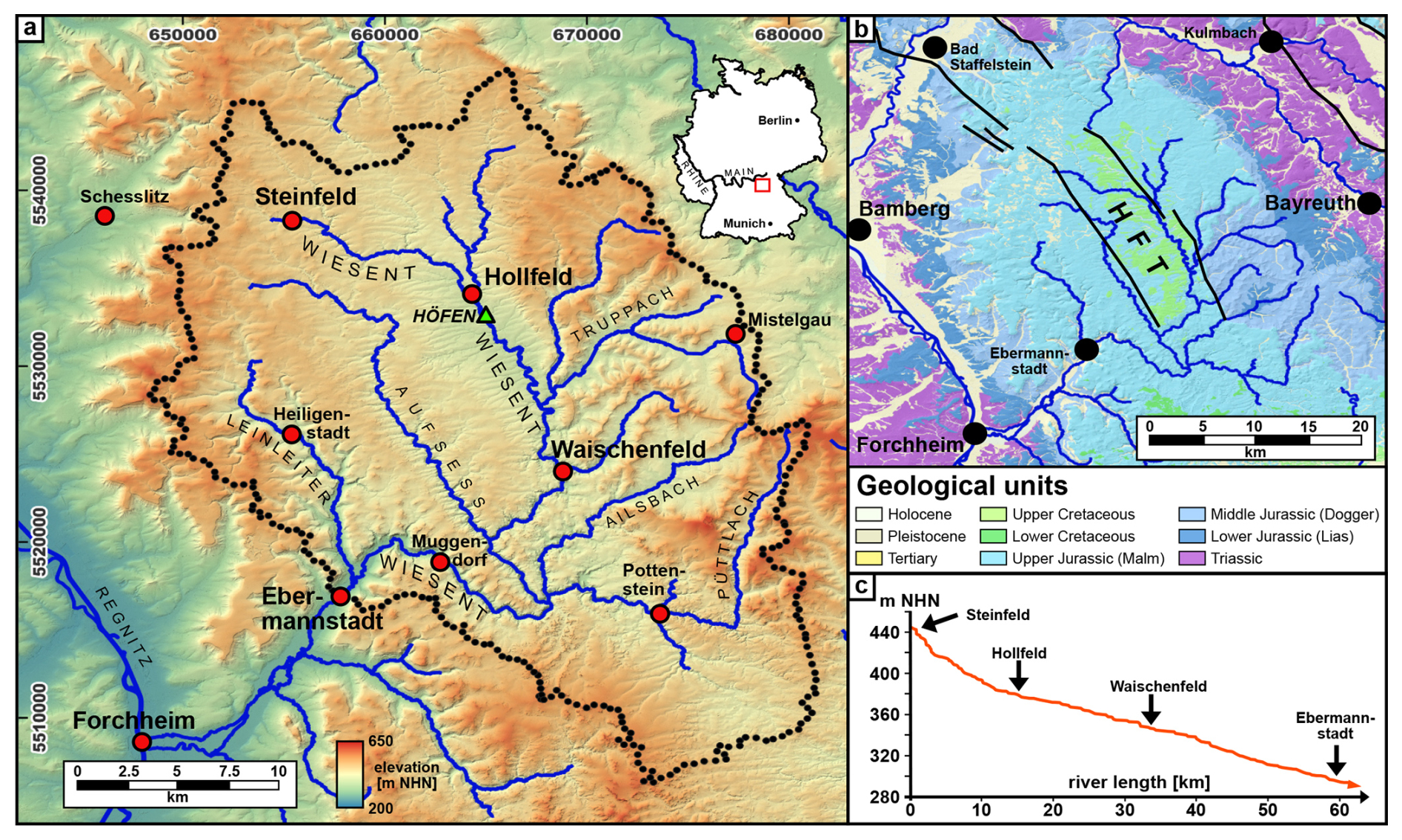
Figure 1(a) The Wiesent River catchment in the Northern Franconian Alb, indicating the study area (dotted line) and the Höfen site (green triangle), where the preliminary results were obtained. (b) Geological and tectonic setting. HFT denotes Hollfeld Trough (see Sect. 2.1). (c) River longitudinal profile of the Wiesent River in the study area, with cities for orientation. Coordinate system of (a) and (b): ETRS89/UTM Zone 32 N, EPSG:25832. DTM1 of the Bayerische Vermessungsverwaltung, https://www.ldbv.bayern.de/ (last access: 26 May 2023); GK500 of the Bayerisches Landesamt für Umwelt, https://www.lfu.bayern.de/index.htm (last access: 14 February 2024).
2.1.1 Geology and geomorphology
The Northern Franconian Alb is part of the South German Scarplands, dominantly composed of Jurassic carbonate rocks (Fig. 1b). The lithology consists of limestones, dolomites, and marls with sandstones in places, building a widespread undulating karstic plateau (Geyer and Schmidt-Kaler, 2009; Schröder, 1978). The average elevation of the plateau is ca. 450 m a.s.l., with maximum elevations up to 600 m a.s.l. (Hohenmirsberger Platte, 614 m a.s.l.) and minimum elevations of 300 m a.s.l., represented by the deeply incised valleys. The geological evolution of the region was significantly influenced by tectonic uplift during the Lower Cretaceous, which facilitated intense karstification of the carbonate rocks under wet–warm tropical to subtropical climates (Peterek and Schröder, 2010; Pfeffer, 1989; Schirmer, 1985). Tectonics also led to the development of the NNW–SSE-trending Hollfeld Fault (HF), resulting in a prominent morphological depression known as the Hollfeld Trough (HFT), in which the Jurassic carbonates are often overlain by a thin veneer of Upper Cretaceous sands (Eberts, 2022; Peterek and Schröder, 2010). Periglacial conditions during the Pleistocene enabled the deposition of a thin loess cover and the formation of periglacial cover beds, representing the parent material for Holocene soil formation, as well as, partly, landslides (Fuchs et al., 2011; Jäger et al., 2013). Today, the dominant soil types are Cambisols and Luvisols on the plateaus, while Gleysols and Fluvisols are typical for the valley floors (Kothieringer et al., 2022). The presence of thick colluvial deposits in foot-slope positions is indicative of widespread soil erosion (see Sect. 2.3) (Kothieringer et al., 2022), responsible for thick Holocene alluvial deposits on the valley floors (Fuchs et al., 2011).
By the onset of the Pleistocene, rivers had already deeply incised into the karst plateau of the northern Franconian Alb, creating steep and narrow valleys up to 180 m (Meyer and Schmidt-Kaler, 1992; Schröder, 1971). Because of the different Pleistocene incision rates between main and side valleys (Schirmer, 2010; Schröder, 1968, 1971), the confluence of the valley floors is often characterized by a small morphological step of up to 2 m. The confluence of the side and main valleys has sometimes resulted in small alluvial fans, locally deflecting the course of the main river Wiesent and its tributaries to the opposite side of the valley (Müller, 1959; Schröder, 1968). Fluvial terraces, as well as calcareous tufa terraces, are, however, scarce or completely absent in the study area (Brunnacker, 1955; Wippern, 1955). The narrow valley floors are generally 50 to 70 m wide, with a maximum width of up to 150 m (Fig. 2a–c). Only in the lowermost reach of the main river Wiesent does the valley morphology change from a narrow to a wide valley floor, which increases continuously from the town of Streitberg, where the valley floor shows a width of ca. 300 m, to the town of Forchheim, with a width of ca. 1–2 km. The rivers generally meander in a floodplain, which has been extensively modified by human impact. Infrastructure such as roads and settlements and the intensified agricultural land use changed the natural environment to a human-dominated environment (see Sect. 2.2). Only some minor river sections, such as the lower reaches of the river Aufsess, remain almost free from modern infrastructure. However, almost all floodplains are used as meadows, and only small areas are covered with riparian forest.
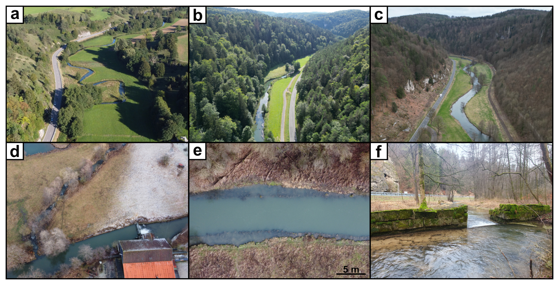
Figure 2Environmental and historical–archaeological characteristics of the Wiesent River valley. (a) The Wiesent River valley upstream, (b) in its middle course, and (c) in the lower course. (d) A mill with a typical mill channel near Waischenfeld, (e) former bank reinforcements recognizable from a drone picture, and (f) the rest of a small weir at the Wiesent River.
2.1.2 Stratigraphy of the alluvial sediments
The valley fillings of the northern Franconian Alb typically consist of thick deposits of limestone and dolomite gravels, covered by 2–3 m thick overbank deposits (Fuchs et al., 2010, 2011; Schirmer, 2014). This general stratigraphic situation is characteristic for many central European mesoscale catchments (Kaiser et al., 2025; Notebaert et al., 2014; Notebaert and Verstraeten, 2010). The transition between gravels and overbank deposits is often characterized by interspersed organic-rich and humic sediments or peat, which formed from the beginning of the Holocene until ca. 4 ka in a marsh-like and aquatic landscape with anastomosing rivers (Fuchs et al., 2011; Schirmer, 2014). Such peat sequences were dated at the Aufsess River to 7.4±0.07 ka BP (Fuchs et al., 2010, 2011), aligning closely with findings from other peat sequences and clay-rich and/or humic sediments in floodplains across central Europe (Kaiser et al., 2025; Lespez et al., 2005; Notebaert et al., 2011b). In addition, thin gravel layers are sometimes intercalated between the overbank deposits and the peat sequences (Kaiser et al., 2025; Lespez et al., 2008). The start of silty–loamy homogenous overbank deposition has been dated to between 2.4 and 3 ka at the Aufsess River, a tributary of the Wiesent River (Fuchs et al., 2011), consistently with similar timelines for several rivers throughout central Europe (Kirchner et al., 2022; Notebaert and Verstraeten, 2010; Von Suchodoletz et al., 2024). It is most probable that it was with the onset of human impact and agricultural activity that the rivers began to meander (Fuchs et al., 2011).
2.1.3 Climate and hydrology
The Wiesent River catchment is situated in the transitional zone between oceanic and subcontinental climates. Average annual precipitation on the plateau is ca. 800–900 mm, and mean annual temperature is ca. 8–9 °C (Deutscher Wetterdienst, 2021a, b). The mean discharge for the upper Wiesent River was 1.05 m3 s−1 (1959–2012, gauge Hollfeld, Fig. 1a) and increased to 7.21 m3 s−1 (1957–2012, gauge Muggendorf, Fig. 1a) (Bayerisches Landesamt für Umwelt, 2015a, b). The river's bedload is predominantly composed of fine-grained materials such as silt and clay, which is also reflected in the observed water turbidity, and there is minimal evidence of recent gravel deposits along the river (Strohmeier and Bruckner, 2013).
Throughout the Holocene, several climatic events have influenced the region. One prominent example is the abrupt temperature drop during the 8.2 ka event, which was associated with an increased deposition frequency of subfossil oaks along the Main River attributed to intensified flood activity (Spurk et al., 2002). For the subsequent millennia, available evidence is sparse; however, a phase of reduced river activity and precipitation between ca. 3500 to 1200 BCE suggests relatively stable climate conditions (Spurk et al., 2002). In contrast, Schoenbein et al. (2015) document unfavourable wet conditions and an increased frequency of floods in the 3rd millennium BCE. From the Middle Bronze Age onwards (from ca. 2000 BCE), the region experienced renewed climatic deterioration. Cooler and wetter conditions associated with the Löbben Oscillation from 1600 BCE led to increased discharge and flooding in the northern Franconian Alb (Haas et al., 1998; Kothieringer et al., 2022; Wipf, 2001). The absence of oak trunks in the Main River deposits from ca. 1200 BCE onwards is interpreted as evidence of increasing human impact, particularly widespread deforestation within the catchment (Spurk et al., 2002). During the Early Middle Ages, warmer conditions combined with a reduced discharge, commonly referred to as the Medieval Climate Optimum (ca. 950–1250 CE), affected the wider region (Kluge et al., 2023). In 1342 CE, the well-known St. Mary Magdalene's flood caused extreme flooding in the Main catchment; however, this event has only been documented in areas directly adjacent to the northern Franconian Alb and has not yet been confirmed within the study area itself (Dotterweich, 2003, 2005; Dotterweich and Bork, 2007). The subsequent Little Ice Age (LIA) was characterized by predominantly cold winters and recurrent severe floods. Speleothem records from a cave in the Püttlach valley, ca. 2 km southeast of Pottenstein, indicate alternating dry phases and periods of increased flood activity in the study area (Kluge et al., 2023). Enhanced flood frequencies for the rivers Main and Pegnitz are reported for the periods 1540–1600, 1640–1700, 1730–1790, and 1790–1840 CE, with outstanding floods between 1550 and 1590 CE and in the 1780s CE (Brázdil et al., 1999; Glaser et al., 2010; Glaser and Hagedorn, 1991; Kluge et al., 2023).
2.1.4 Vegetation and land use
Originally, a sparse beech-dominated forest type with a heliophilic and thermophilic herbaceous layer, commonly referred to as sedge-beech forest, was considered to be the northern Franconian Alb's potential natural vegetation (Böhmer, 1994). Prior to the Iron Age, however, oak and beech were also widespread on the plateaus (Kothieringer et al., 2022). In contrast, the southern Franconian Alb included pines alongside oaks within the natural vegetation (Baumann, 2006). Instead of a simple shift from woodland to open land, recent studies suggest rotational woodland use and silvopastural practices, which would explain the persistence of mixed oak–beech forests even under substantial human pressure (Bogaard, 2004; Böhmer, 1994; Rösch et al., 2004; Schier, 2009). Since the Neolithic, deforestation has primarily occurred through a rotating system of “slash-and-burn” culture, agricultural use, and fallow land for 1 or 2 decades (Bogaard, 2004; Schier, 2009). For high medieval colonization, however, toponyms with *-reuth and its derivatives have been interpreted as large-scale clearances (George, 2008; Pfanner, 1965; Schwarz, 1960). These cleared areas were then used for agriculture and cultivated within the open-field system, although no detailed archaeological investigations of such have been carried out so far (Schreg, 2018, 2024). The geology and morphology of the northern Franconian Alb (see Sect. 2.1, Fig. 1), however, restrict arable agriculture and contributed to extensive rather than intensive land use systems, particularly on the plateau and steep slopes. The lack of water springs on the plateau permitted only rain-fed agriculture, making woodland-based and pastoral uses comparatively more important.
A decisive factor in shaping the vegetation was sheep grazing, documented since the Middle Ages due to rising wool demand (Bender et al., 2005; Böhmer and Bender, 2000; Weisel, 1971). Because steep valley slopes were unsuitable for cultivation, they became long-term grazing zones, where sheep created specific ecological conditions, which led to open landscapes and semi-dry grasslands with juniper heaths (Böhmer, 1994; Böhmer and Bender, 2000). These habitats, often interpreted today as “natural”, are in fact cultural landscapes resulting from continuous grazing pressure, which have shaped the valleys of the northern Franconian Alb until today (Bender et al., 2005; Böhmer and Bender, 2000). Over the centuries, a sheep-raising system with manorial sheep farms has developed, each averaging around 1000 sheep and peaking at 177 000 sheep in total around the 1850s in the area (Bender et al., 2005; Weisel, 1971). This led to local overgrazing, which, in turn, caused soil erosion (Bender et al., 2005). In contrast, valley floors remained largely grassland, supporting winter stabling and hay production in the region's municipal sheep-farming system (Hornberger, 1959). The rising need to feed more animals in winter increased hay demand and may have prompted the development of the water meadows (see Sect. 2.2.2, Fig. 4), which, in turn, play a major role in hydrosedimentary functioning and sediment transport from the slopes and alluvial plains to the river channel. The collapse of large-scale sheep farming in the 19th century, driven by cheap wool imports and agricultural modernization, triggered rapid reforestation and the decline of juniper heaths, leaving only small remnants on actively grazed slopes today (Bender et al., 2005; Böhmer, 1994; Schmitt, 1998).
As agriculture, mills, and timber-related activities (like rafting) depended on the same water resources, disputes about water use and the accessibility to water were frequent, at least from the 16th century onwards (e.g. Staatsarchiv Bamberg (StABa): Archiv der Grafen von Giech zu Thurnau, Akten (G65/III) 2979 [1563–1772]; StABa: Hochstift Bamberg, Vogt- und Steueramt Scheßlitz 231 [(1622–) 1775–1795]). A local example is the attempt to make the Wiesent River “raftable” for timber transport, which seems to have failed due to high costs and the limited navigability in the receiving waters of the Regnitz River caused by in-stream structures (Staatsbibliothek München (StBM): 4 Bavar. 3287 [ca. 1870]; (StABa: Regierung von Oberfranken, Kammer des Innern (K 3 F V a) 1720 [1811–1818]).
2.2 Archaeology and history
2.2.1 Socio-ecological development until the Late Middle Ages
Early prehistoric settlement in the German Central Uplands was concentrated in valleys, although plateau occupations (e.g. Ehrenbürg) occurred in the northern Franconian Alb (Abels, 2023; Kothieringer et al., 2018; Müller and Seregély, 2008; Seregély et al., 2024; see Fig. 4). Valley locations offered agricultural advantages, while plateaus were likely to be used seasonally for grazing or cultivation (Kothieringer et al., 2018; see Sect. 2.1.4). Major landscape modification began in the Middle Bronze Age (16–14th century BCE), especially in valleys, coinciding with increased plateau use during the Urnfield Culture from the 13th century BCE (Kothieringer et al., 2018). After sparse Early Iron Age evidence, renewed activity is visible in Early La Tène valley sites, followed by reforestation in the Late La Tène period until land use expansion in the Early Middle Ages (Kothieringer et al., 2018; Seregély et al., 2024).
Continuous settlement of the Regnitz lowlands in Roman and early medieval times reflects the region's importance for communication routes along the rivers Main, Regnitz, and Altmühl (Brather, 2023; Haberstroh and Faßbinder, 2003). From the 5th century on, Upper Franconia attracted the interests of the Juthungi; the Burgundians; the Franks; and, mainly, the Thuringii, whose influence was found in artefacts, for example, from Altendorf and Staffelstein (Haberstroh and Faßbinder, 2003; Koch, 2003; Werther, 2011; Fig. 4). After the Merovingian Frankish defeat of the Thuringian Kingdom in 531 CE (Störmer, 1999; Theune, 2005), Frankish influence increased, and the Franconian Empire expanded fast in the late 5th and 6th centuries (Haberstroh and Faßbinder, 2003; Koch, 2003), although archaeological and linguistic evidence (oikonyms) points to parallel Slavic presence from the 6–7th centuries onwards (Fastnacht, 2000; Guttenberg, 1952; Losert, 1993). Following the early 7th century “Slavic Kingdom” (of Samo) and its victory over the Franks (under Dagobert I), intensified Frankish activity along the Main and in Thuringia led to the consolidation of regional power in the Hedenen duchy centred on Würzburg, controlling the area until 719 CE, and enabled the subsequent formation of the Würzburg bishopric (Werther, 2011).
Debate persists over early Franconian versus Slavic settlement in the northern Franconian Alb, but mid-8th-century oikonyms in the Donation of Pepin the Short point to sustained Franconian influence, while the limited written and archaeological evidence renders Slavic migration patterns uncertain (Andraschke, 2020; Janka, 2023; Klír, 2016; Losert, 1993; Störmer, 1999). References in the Donation and the Diedenhofen Capitulary (805 CE) to Hallstadt, Königsfeld, and Forchheim as royal palatinates, tariff sites, and/or trade regulations with the Slavs suggest a coordinated Frankish administrative strategy (Störmer, 1999; Werther, 2011, Fig. 4). Together with Charlemagne's network of “Slav churches” (Slawenkirchen), also intended to secure key waterways (Störmer, 1999), the presence of “German” and mixed (“Slavo-German”) oikonyms along the rivers and a greater density of Slavic names on the plateaus indicate a diverse landscape, pivotal for trade and conflict among the Franks and Bavarians with the Saxons, Slavs, and Pannonian Avars (Werther, 2011). By the 8th to 9th centuries, Upper Franconia became part of the Eastern Frankish Kingdom (Francia Orientalis), enhancing Forchheims royal palatine status due to its strategic position at the confluence of the rivers Wiesent and Regnitz (Störmer, 1999). Archaeological findings indicate trade relations with western Bohemia and the Rhineland and Bavarian regions (Hoffmann, 2018). Territorial consolidation under noble families (e.g. Younger House of Babenberg) increased in the 10th to 11th centuries, accompanied by the establishment of the Archdiocese of Bamberg in 1007 CE, aiming partly at Slavic Christianization (Störmer, 1999; Werther, 2011).
During the 11th to 12th centuries, the construction of a royal castle in Nuremberg waned Bamberg's influence, and church reforms led to the end of the imperial church system (Störmer, 1999), consolidating local power to noble families, expressed in a period of castle-building (Voit et al., 1992), e.g. by the castles of Truppach, Gößweinstein, Pottenstein, and Waischenfeld. These changes marked a shift towards a (secular) “nationalization” and a gradual separation from feudalism (Störmer, 1999). In southern Germany, the manorial system consolidated around rural castles, fostering stronger municipal peasant institutions and contributing to 11th- to 12th-century village formation and the spread of the open-field system (Schreg, 2009, 2019). Archaeological findings in NE Bavaria show that earlier settlements often lay outside later village cores, indicating nucleation around churches or manorial centres and a shift towards more intensive land use (Ebersbach, 2002; Schreg, 2006, 2009), which likely increased erosion and sedimentation (see also Sect. 2.3).
From the 12th century, the northern Franconian Alb became a contested boundary region between Bamberg, Nuremberg, and local dukes because all power over the Bishopric and duchy of Franconia was granted to the bishop of Würzburg (“Güldene Freiheit”, Fig. 4), a status upheld until the end of the Holy Roman Empire (Voit et al., 1992). After the area was divided in 1260 CE among Bamberg, Nuremberg, and several dukes holding their territories as fiefs from the Prince-Bishopric for military support, the Bishopric also ceded the tithes of Eggolsheim, Senftenberg, Neideck, and Gößweinstein to the Schlüsselberg dukes (Voit et al., 1992). By blocking the Nuremberg–Bayreuth–Leipzig trade route by the castles Neideck and Streitberg (Schlüsselberg dukes), the burgraves of Nuremberg were prompted to ally with the Bishops of Würzburg and Bamberg, dismantling the reign of the Schlüsselberg family, and partitioned their territories following the death of Konrad II. (Fig. 4) (Schiener, 2022). Nuremberg gained control over several castles and the Franconian Alb trade route, including the “right of escort” or “Geleitrecht” (Schiener, 2022). Other noble families, such as the Aufsess, experienced similar declines while Bamberg gained regions including the castles of Giech and Arnstein, establishing boundaries (Prince-Bishopric of Bamberg, Principality of Bayreuth) that remained stable until the end of the Holy Roman Empire (Voit et al., 1992).
2.2.2 Early modern hydrological installations and river adjustments
As a rural landscape, the northern Franconian Alb featured only small-scale hydrological installations and river modifications, while its floodplains were predominantly used for farming. Small weirs and channels supported meadow irrigation systems, mill races were constructed within the floodplain, and water wheels were installed in the rivers (Figs. 3 and 4). Historical sources also report that sheep were washed in the Wiesent River at Ebermannstadt (Staatsarchiv Bamberg (StABa): Landgericht ä. O. Ebermannstadt (K8) 6729 [1805]). These installations with, for example, artificial barriers led to changes in the sediment dynamics, the riverbed morphology, and the bedload structure and consequently resulted in different behaviour of the entire river system (Strohmeier and Bruckner, 2013).
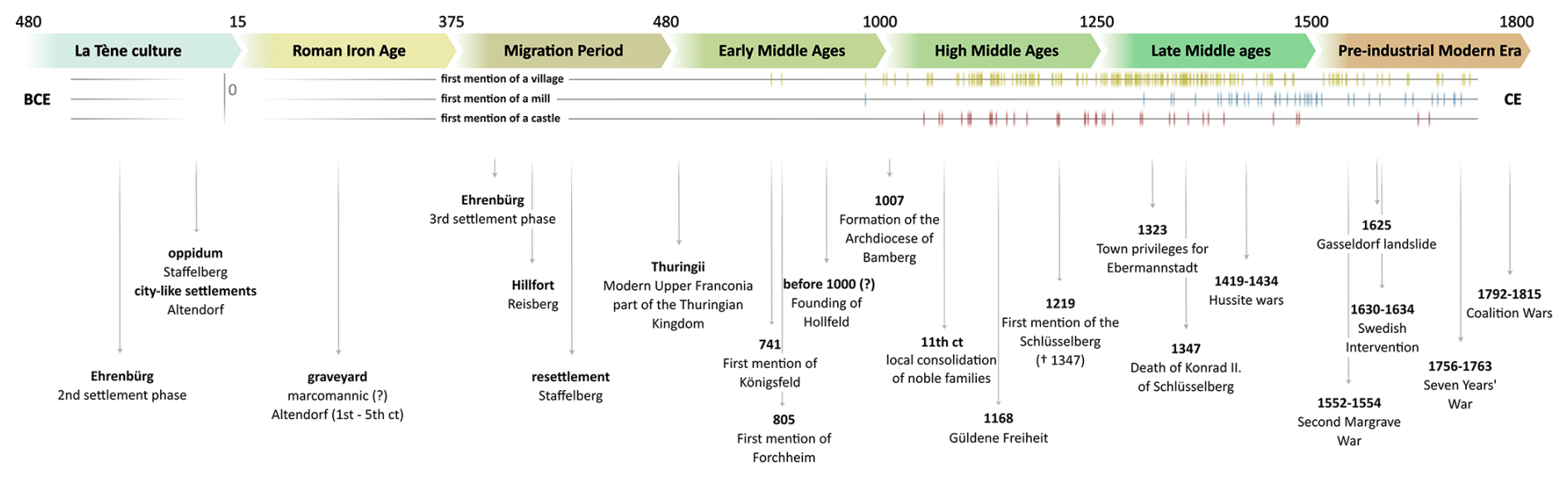
Figure 3Timeline of the historical–archaeological events in Upper Franconia. First documentary mentions of villages, mills (see also Sect. 2.2.2), and castles within the study area were compiled from Guttenberg (1952), Pfanner (1965), Haversath (1987) Fastnacht (2000), George (2008), and archival records in the Staatsarchiv Bamberg. Events shown in the lower part of the timeline are based on Voit et al. (1992), Losert (1993), Störmer (1999), Haberstroh and Faßbinder (2003), Koch (2003), Müller and Seregély (2008), Werther (2011), and Abels (2023), as referenced in the main text. Additionally, data from Fastnacht (2000), Haberstroh and Faßbinder (2003), Jäger et al. (2013), and Abels (2023) were used as orientational markers for first mentions of place names within the study area and for Neolithic settlement evidence.
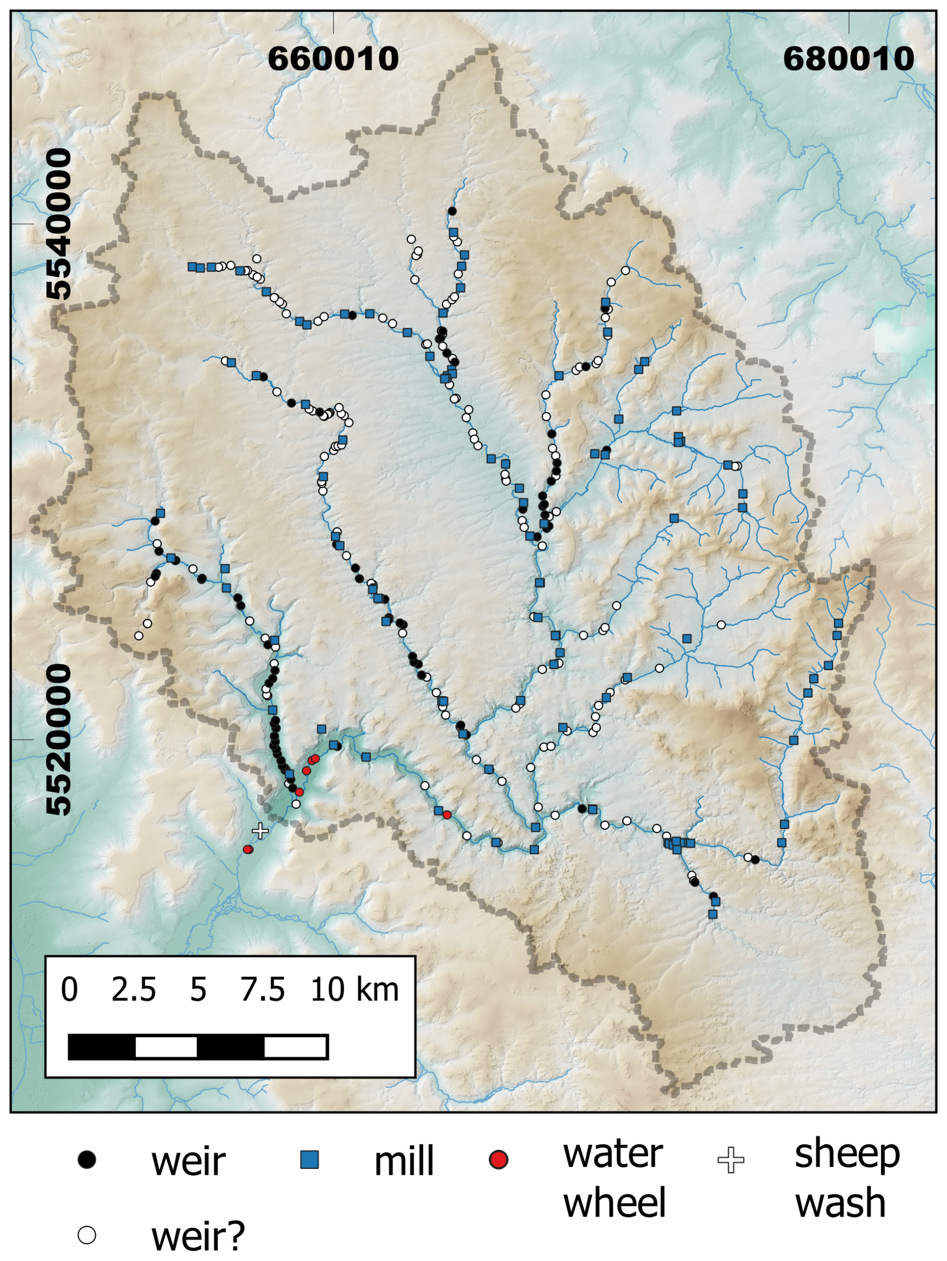
Figure 4Spatial distribution of mills, weirs, water wheels, and the sheep wash within the Wiesent River catchment (see Fig. 1 for geographic orientation). Locations of mills and weirs were derived from archival cadastral maps (Urkataster) and the DTM1, water wheels were derived from the cadastral maps and historical field names (toponyms), and the sheep wash was derived from archival sources of the StABa (A240, Rgr. 3). Coordinate system: ETRS89/UTM Zone 32 N, EPSG:25832. DTM1 of the Bayerische Vermessungsverwaltung – https://www.ldbv.bayern.de/ (last access: 26 May 2023).
Although many mills were built alongside the Wiesent River and its tributaries (Fig. 4), most mill owners supplemented their incomes through farming as mill profits alone were insufficient for sustainable livelihoods (Haversath, 1987). Still visible in aerial pictures of the allies (e.g. picture no. 451627_1_4074, taken on 17 February 1945, ©LDBV), the 1960s and 1970s marked the obsolescence of traditional irrigation systems as growing mechanization rendered small ditches and weirs impractical. Consequently, these structures fell into disrepair or were dismantled.
The importance of river adjustment maintenance is evident from the 19th- and 20th-century farmer petitions for permission to repair damaged and eroded river banks, driven by land loss and economic impacts. Sketches accompanying these documents reveal the potential loss of hundreds of square metres of land. Furthermore, intact river banks were vital not only for farmers but also in historical territorial disputes. Maps from the 18th century illustrate the conflicting claims of Bamberg and Bayreuth over the border at the Aufsess River, emphasizing the river's importance in local geopolitics (e.g. StABa: R. 411 [1749]).
Records of fish water rights or files for fishing in the study area are notably sparse. While some files exist (StABa: Archiv der Grafen von Giech zu Thurnau, Akten (G65/III) A 5402 [(1563) 1844–1911]), their rarity raises questions about the frequency of fishing-related conflicts, possibly reflecting a comparatively lower population density typical of rural regions. Supporting this hypothesis, toponyms related to fishing are also infrequently encountered.
2.3 Human-induced sediment dynamics in the catchment
With settlement activity beginning in the Neolithic period, forest clearance on the plateaus (see Sect. 2.1.4 and 2.2.1) initiated increased soil erosion (Fuchs et al., 2010, 2011; Kothieringer et al., 2022; Schirmer, 2014). This resulted in the deposition of colluvial and alluvial sediments in the hitherto marsh-like and aquatic valleys (Fuchs et al., 2010, 2011; Schirmer, 2014). As a consequence, the aquatic landscape with anastomosing rivers changed to single-channel meandering rivers with the formation of thick overbank deposits and therefore provided, for the first time, a utilization of the valley floors after 4 ka (Fuchs et al., 2011; Schirmer, 2014).
It should be noted that sediment archives often record environmental changes discontinuously. Eroded soil material may initially be stored as colluvial material in sediment traps on-slope or at foot-slope positions before being deposited as alluvium in the floodplain (Fryirs et al., 2007; Trimble, 1999; Viel et al., 2024). This temporal decoupling between erosion and sedimentation exemplifies the concept of sediment cascades, where eroded sediments are temporarily stored before being deposited in the floodplain (Fryirs, 2013). Human activities, especially since the Neolithic, have significantly amplified sediment fluxes through increased soil erosion driven by agricultural expansion and deforestation in many mesoscale fluvial systems throughout Europe (Broothaerts et al., 2014b, c; Hoffmann et al., 2010; Lang, 2003; Viel et al., 2024). These anthropogenic impacts have altered hillslope–channel connectivity and sediment transfer pathways, often leading to a lagged response in floodplain sedimentation that complicates the interpretation of sediment archives (Hinderer, 2012; Lespez et al., 2008; Notebaert et al., 2018). This must also be taken into account in the Wiesent River catchment (Fuchs et al., 2010, 2011). Moreover, recent studies highlight that changes in landscape organization – such as modifications in land use patterns and infrastructure development – influence sediment connectivity and storage, emphasizing the importance of integrating landscape history and human impact assessments when reconstructing long-term sediment dynamics (Verstraeten et al., 2017; Viel et al., 2014).
In the northern Franconian Alb, increased settlement activity, as well as more intense agricultural practices and deforestation from the Middle Ages onwards (see Sect. 2.1.4), caused significantly higher soil erosion within the catchment, which, in turn, resulted in higher sedimentation rates (up to 2 mm yr−1) within the floodplain, causing thick overbank deposits (Fuchs et al., 2011). Linear soil erosion has also increased significantly in some parts of the catchment, resulting in gullies up to 10 m deep, such as near the confluence of the rivers Aufsess and Wiesent. As the periglacial cover beds were also subject to erosion, it is sometimes difficult to distinguish between sediments from soil erosion (colluvium) and those from eroded periglacial cover layers if no direct indicators (e.g. sherds or charcoal) characterize the sediment in more detail (Fuchs et al., 2011). Forest clearance in valleys and on slopes also reduced flood protection and increased the exposure of bedrock, potentially leading to landslides as observed around Ebermannstadt (Hütteroth, 1994; Schröder, 1971).
2.4 Key insights and synthesis of the review
The environmental, archaeological, and historical evidence presented in this review shows that the Wiesent River catchment's development has been driven by both natural processes and anthropogenic disturbance, at least over the last millennia. While valley floor peat formation on top of Early Holocene gravel or sand bodies and overbank deposition reflect broader central European patterns, archaeological and historical sources show a rural area with repeated phases of settlement expansion, forest clearance, grazing, and agricultural restructuring that progressively transformed the hydrological and sedimentary behaviour of the catchment. These activities contributed to the shift from Early Holocene wetland landscapes to meandering single-channel systems with thick overbank deposits. Later medieval and early modern hydraulic installations, including mills and meadow irrigation systems, further influenced channel morphology and sediment dynamics. Overall, the review underscores the dominant role of human activity in shaping sediment fluxes, deposition patterns, and floodplain morphology in the Wiesent River catchment.
Here, we present the first field-based and laboratory investigations conducted in the Wiesent River floodplain, building directly on the multidisciplinary review outlined in the preceding chapter. While the review established a baseline understanding of environmental conditions and human interactions, empirical data are required to evaluate floodplain development and depositional processes.
Initial sedimentological analyses of drill cores are used to characterize floodplain stratigraphy and to distinguish phases of organic and clastic deposition. These point-basis observations are complemented by electrical resistivity tomography (ERT) surveys, which provide spatial insights into subsurface geometry, sediment bodies, and sedimentary floodplain architecture. Together, these approaches offer a first empirical assessment of the floodplain as a geoscientific archive.
3.1 Methods
Initially, morphological analyses based on a lidar-derived digital terrain model (DTM) were conducted prior to fieldwork to identify suitable working areas along the floodplains. The DTM also provides a basis for delineating the spatial extent of floodplains and their natural and anthropogenic features (e.g. oxbow lakes or hydrotechnical installations) and for defining characteristic valley sections.
3.1.1 Electrical resistivity tomography (ERT)
Electrical resistivity tomography (ERT) surveys were carried out to obtain subsurface information and support stratigraphic interpretation as this method is well suited to detecting, for example, buried river channel patterns or oxbow lake structures (Kirchner et al., 2022; Von Suchodoletz et al., 2022). In addition, the ERT results were used to identify appropriate drilling locations within the investigated valley sections (Kirchner et al., 2018). The ERT profiles were conducted using a GeoTom MK1E100 device equipped with 48 electrodes distributed over two cables in a Schlumberger electrode array (Kneisel, 2003). Electrode spacing was set to a minimum of 1 m. Data processing was performed using Res2DInv x64 software, version 4.10.20 (Aarhus GeoSoftware, 2022).
3.1.2 Sedimentology and stratigraphy
Floodplain stratigraphy was studied across floodplains along the ERT transects by means of percussion drilling, followed by sedimentological analyses in the laboratory. All percussion drilling was conducted using an electrically driven Makita HM1400 drill hammer and 1 m long auger steel cores (∅60 mm). The extracted sediment cores were described and sampled in the field according to the German soil description guidelines (Ad-hoc-AG Boden, 2005) and the Munsell Soil Color Charts (Munsell Color Laboratory, 2000). Samples were further analysed in the laboratory by means of grain size distribution and organic content.
Grain size distribution was obtained by means of the sieve and pipette method after Köhn (Köhn, 1929; Deutsches Institut für Normung, 2002) for subsamples of 10 g. Prior to the analysis, the samples were dried at 35 °C, carefully pestled by hand, and sieved for the <2 mm fraction. All samples were then pre-treated with 10 mL 30 % hydrogen peroxide (H2O2) per sample to remove the organic matter, and distilled water and dissolved tetra-sodium pyrophosphate (Na4P2O7 ⋅ 10 H2O) were applied for 4 h in a shaker for aggregate dispersion (Deutsches Institut für Normung, 2002; Pye and Blott, 2004). Samples that contain grain sizes of >2 mm were wet-sieved for the fine, middle, and coarse gravel fractions (Deutsches Institut für Normung, 2002). The results of the Köhn method were corrected afterwards with the gravel fractions to gain insight into the realistic grain size distribution.
Loss on ignition (LOI) as an inexpensive, convenient, and accurate method to determine the concentration of organic matter in each sample was carried out by drying subsamples of 5 g by 105 °C for 12 h and then heating the sediment samples for 4 h at 550 °C (Abella and Zimmer, 2007; Blume et al., 2011; Deutsches Institut für Normung, 2021; Heiri et al., 2001). LOI values were corrected by subtracting 0.1 % per 1 % clay due to possible structural water loss in samples with high clay or sesquioxide content (Blume et al., 2011; Schmidt and Scheibner, 1988).
3.2 First field and laboratory results
The first geoelectrical and sedimentological investigations at the Höfen site (approx. 2 km south of Hollfeld; see Fig. 1) provide valuable insights into the floodplain evolution of the Wiesent River floodplain (Figs. 5 and 6). The Höfen (HÖF) site was selected because its stratigraphic characteristics are consistent with observations from other investigated locations along the Wiesent River. Consequently, it can be regarded to be a representative site for the floodplain sedimentary development within the study area.
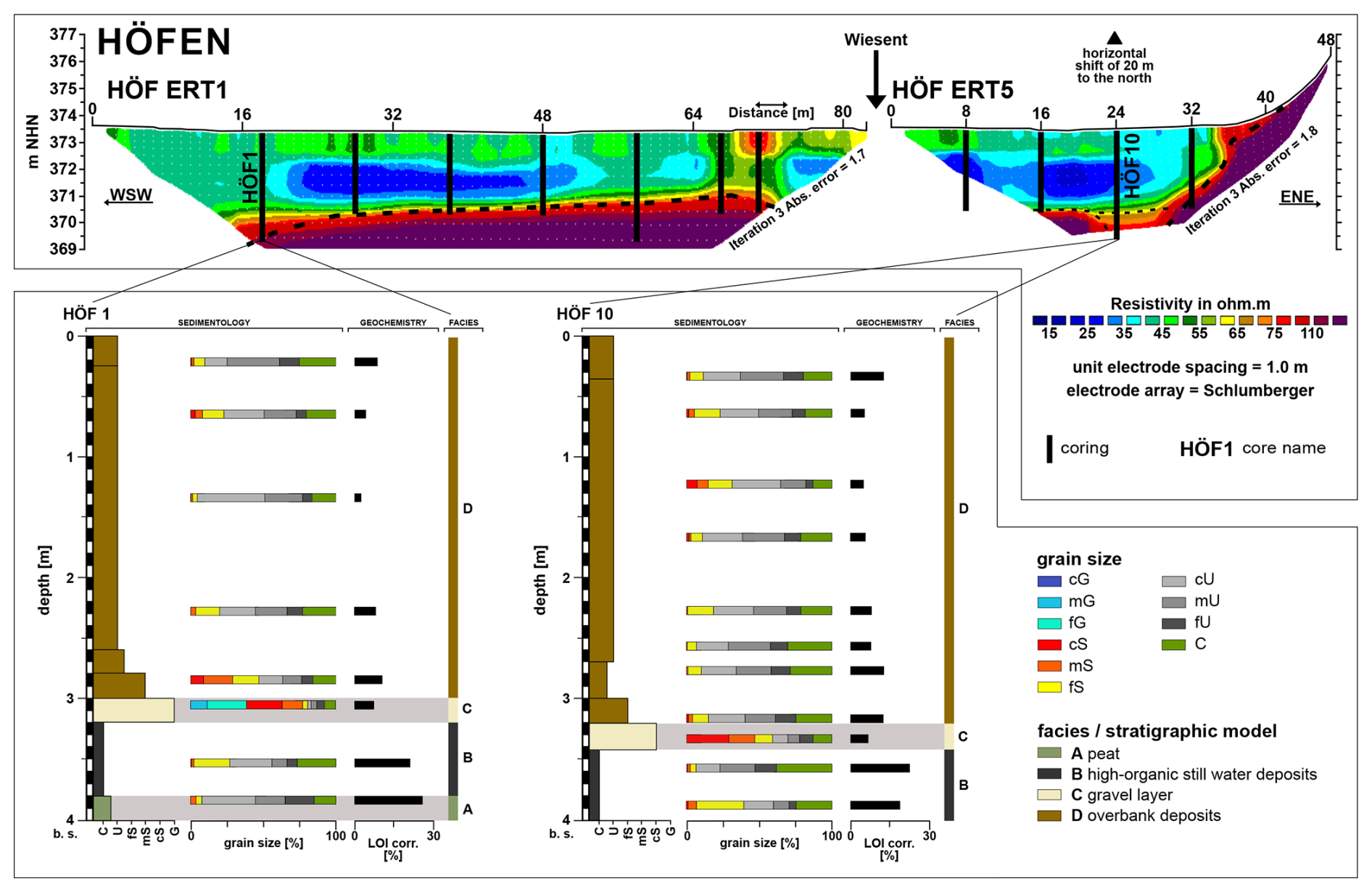
Figure 5First geoelectrical and sedimentological results from the Höfen site (HÖF) indicating the stratigraphic cross-section in Fig. 6. Upper part: electrical resistivity tomography profiles HÖF ERT1 and HÖF ERT5, with coring positions, giving an overview of the Wiesent River floodplain. Lower part: laboratory results of sediment cores HÖF1 and HÖF10, with grain size distribution, organic content (LOI), and interpreted facies and/or stratigraphic model.
3.2.1 Electrical resistivity tomography results
Electrical resistivity tomography surveys were conducted across the Höfen site as valley-crossing transects covering the entire floodplain (Fig. 5). The resulting ERT profiles reveal pronounced variations in subsurface resistivity, which can be related to differences in sediment composition and depositional environments. Overall, high-resistivity anomalies are interpreted as coarse-grained sediments (e.g. gravel, sand, or bedrock), whereas low-resistivity zones predominantly reflect fine-grained deposits, such as silts and clays.
The HÖF ERT1 transect shows a basal unit of relatively high resistivity, interpreted as coarse-grained sediments, overlain by approximately 3–4 m of low-resistivity material corresponding to fine-grained deposits (Fig. 5). A similar succession is observed in the HÖF ERT5 transect. Towards the right end of valley floor in HÖF ERT5, resistivity values increase again with elevation, which likely indicates the transition from unconsolidated sediments to bedrock at the valley margins (Fig. 5). A particularly striking feature is observed in the HÖF ERT1 transect, where a distinct, laterally confined high-resistivity anomaly appears on the right-hand side of the section (Fig. 5). This structure may form some kind of a paleochannel, reflecting the presence of coarser channel fill sediments embedded within fine-grained deposits (indicated by reddish colours on the right side). A comparable, though less pronounced, paleochannel-like feature is also visible in the lower part of HÖF ERT 5. This feature spatially coincides with the location of the drilling of core HÖF10, which penetrated the inferred channel fill deposits.
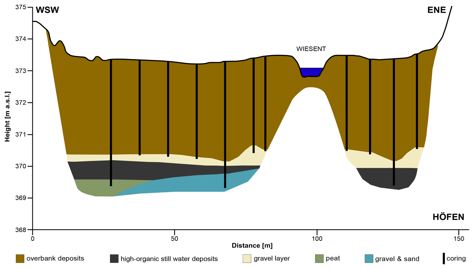
Figure 6Representative schematic valley cross-section of the Wiesent River at Höfen, south of Hollfeld, highlighting the general stratigraphic situation in the Wiesent River catchment with thick overbank deposits based on analyses shown in Fig. 5.
3.2.2 Sedimentological and stratigraphical results
Percussion drilling at the Höfen site along the ERT transects provided continuous sediment cores up to 4 m depth, providing the first detailed stratigraphic framework for the Wiesent River floodplain. The sedimentological characteristics are consistent across the cores, allowing a general stratigraphic succession to be described from base to top, exemplified by the sediment cores HÖF1 and HÖF10.
At the base of the sequence, several drill cores (including HÖF1 and HÖF10) intersected a dark, organic-rich silty clay unit (Fig. 5). Grain size analyses indicate a high clay content, and the unit locally contains visible plant remains. Loss-on-ignition (LOI) values are markedly elevated compared to the overlying units, reflecting a very high organic matter content (Fig. 5). This layer reaches thickness of more than 0.4 m, and, in core, HÖF1 it is underlain by peat with an even higher organic content.
Overlying the organic-rich deposits, all cores contain a laterally continuous layer of white to light-grey coarse sand to fine gravel (Fig. 5). The clasts are well rounded and consist predominantly of limestone and dolomite, as also confirmed by their reaction with hydrochloric acid. Grain size distributions show a dominance of coarse fractions, while LOI values are low, indicating minimal organic matter. The groundwater table was encountered within this unit, which has a maximum thickness of approximately 0.25 m.
The uppermost part of the stratigraphy in all cores consists of up to 3 m of brown-beige silty–loamy sediments. These deposits are homogenous and are characterized by a dominance of fine-grained material, as confirmed by grain size analyses (Fig. 5). LOI values are moderate, indicating relatively low to moderate organic content.
3.3 Discussion and synthesis of first results
In light of the first results and the review (Sect. 2), the investigated valley fill can be interpreted within a conceptional sedimentological floodplain model that integrates stratigraphic observations, laboratory analyses, geoelectrical results, and phases of socio-ecological development documentation for the region. This model provides a framework for understanding the temporal evolution of sedimentation processes and boundary conditions within the study area and comparable central European catchments.
From base to top, the sediment cores and the geoelectrical transects (Fig. 5) reveal a characteristic sedimentary floodplain architecture that closely resembles stratigraphies previously described from the Aufsess subcatchment and other central European floodplains. The lowermost units consist of high-organic deposits (see LOI in Fig. 5), interpreted as still-water deposits and peat (facies A and B), representing phases of reduced fluvial activity and wetland conditions with probably weakly defined channel systems (Fig. 6). These deposits are typical for the early Holocene and are well aligned with the results of the Aufsess River (Fuchs et al., 2010, 2011), as well as with broader regional evidence for organic-rich marsh-like floodplain landscapes during this period (Notebaert et al., 2011b). It also corresponds to periods of low settlement density and limited anthropogenic impact, as indicated by sparse archaeological evidence for early prehistoric land use in valley bottoms (Sect. 2.2.1).
Above these high-organic deposits, thin intercalated gravel layers (facies C) occur, which likely indicate episodes of high-energy fluvial activity (Fig. 6). Comparable gravel interbeds between peat and fine-grained sediments have been documented in numerous central European floodplains and are commonly associated with phases of increased hydrological variability (Kaiser et al., 2025; Lespez et al., 2008). Their limited thickness and lateral continuity suggest short-lived, episodic events linked to the Middle to Late Holocene, predating sustained human control of river systems.
Overlying the basal units, thick sequences of fine-grained, predominantly silty to clayey deposits (facies D) dominate the stratigraphy, also seen in the low resistivities of the ERT transects (Figs. 5 and 6). These sediments mark a fundamental shift in floodplain dynamics towards sustained overbank sedimentation. This transition is consistent with the widespread onset of overbank deposition dated to ca. 2.4–3 ka at the Aufsess River (Fuchs et al., 2011). Laboratory analyses (Fig. 5) of selected core sections (HÖF1, HÖF10) support this interpretation, with grain size distributions showing a dominance of silt and clay, weak sorting, and generally low organic content – characteristic features of low-energy overbank deposition. Importantly, this sedimentological shift corresponds temporally with phases of intensified land use and settlement expansion, including increased valley occupation since the Bronze Age (Kothieringer et al., 2022; Seregély et al., 2024). Similar patterns have been reported from the Aufsess River in the northern Franconian Alb (Fuchs et al., 2011; Schirmer, 2014) and other mid-European mesoscale catchments (Kaiser et al., 2025; Notebaert et al., 2011b, 2014; Von Suchodoletz et al., 2022), where organic-rich basal units grade into increasingly homogeneous silty overbank deposits. These changes are commonly linked to intensified land use and human impact and, thus, soil erosion during the Late Holocene (Dotterweich, 2008; Viel et al., 2024).
In the Franconian Alb overbank, deposition was probably shaped by a long-term interplay of geoscientific boundary conditions and land use change, settlement dynamics, and river regulation. Deforestation already began during the Neolithic period, primarily through rotating systems of slash-and-burn cultivation, but intensified markedly during the Middle Ages, as indicated by toponyms with the suffix *-reuth (George, 2008; Pfanner, 1965; Schwarz, 1960). These large-scale and more permanent forest clearances fundamentally altered vegetation cover and slope stability, thereby changing boundary conditions for overbank sedimentation. From the 11th to 12th centuries onwards, village formation accompanied by settlement nucleation and the spread of the open-field system intensified land use (Schreg, 2009, 2019) and likely promoted soil erosion on slopes and enhanced the continuous supply of fine-grained sediments to the floodplain. The effects of this land use change was amplified by the geomorphological setting of the region, where deeply incised valleys facilitated efficient sediment transfer from hillslopes to valley floors (Sect. 2.1.4). Since the Middle Ages, sheep grazing became a dominant land use practice in the northern Franconian Alb, driven by rising wool demand and persisting until 1850 CE (Bender et al., 2005). The long-term reduction in vegetation cover caused by extensive grazing, particularly on steep valley slopes unsuitable for cultivation, further increased soil erosion and sediment delivery to the fluvial system. These processes likely contributed substantially to the observed increase in overbank deposition during the Late Holocene (Fuchs et al., 2010, 2011). At the same time, the growing number of hydrotechnical installations documented since the medieval period – including mills, weir, mill races, and irrigation structures (Haversath, 1987) – modified flow conditions, sediment trapping, and channel stabilization (Sect. 2.2.2). Such interventions are consistent with documented changes in sediment load and riverbed morphology resulting from anthropogenic river modifications (Strohmeier and Bruckner, 2013), as well as with local disputes about using the rivers for fishing or the floodplains for farming (Sect. 2.2.2). In this context, irrigated meadows probably played a significant role (Sect. 2.2.2, Fig. 4).
Based on the integration of sedimentological data, laboratory analyses, geoelectrical results, and a comprehensive review of the literature of the region (Sect. 2), a representative schematic valley cross-section for the Höfen site is proposed (Fig. 6.). This model provides a unifying framework for interpreting the first results and places the study area within the broader context of central European floodplain evolution.
This study set out to explore the transformation of the Wiesent River floodplain from a predominantly natural system to a human-dominated fluvial system within the conceptual framework of the fluvial anthroposphere. To achieve this, we combined a comprehensive multidisciplinary review of environmental, archaeological, and historical evidence with first geoscientific field and laboratory investigations. The overarching aim was not to provide a complete reconstruction of floodplain evolution but to critically assess existing knowledge, present initial empirical data, and evaluate the suitability of the Wiesent River catchment as a study area for future, more detailed research.
The review demonstrates that the Wiesent River catchment follows a trajectory that is broadly consistent with patterns observed in other central European low-mountain ranges. Early Holocene floodplains were characterized by marsh-like aquatic environments with organic-rich deposits, limited aggradation, and anastomosing or weakly defined channel systems. Archaeological and historical evidence indicated that human presence since the Neolithic progressively altered this system through deforestation, grazing, and agriculture, although the geomorphic response was neither immediate nor linear. Instead, sediment cascades and temporary storages on slopes or foot-slope positions led to a delayed and spatially heterogenous floodplain response. From the Late Holocene and particularly since the Middle Ages, intensified land use, widespread forest clearance, and grazing – most notably sheep husbandry – very likely altered hillslope–channel connectivity fundamentally and promoted sustained overbank deposition.
The first geoscientific results directly address the nature and timing of floodplain transformation and the role of human impact relative to natural controls. Electrical resistivity tomography and sediment core analyses from the Höfen site reveal characteristic floodplain architecture consisting of basal organic-rich deposits and peat; thin intercalated gravel layers; and thick, homogenous silty–loamy overbank deposits. This stratigraphic succession closely mirrors findings from the Aufsess River and other central European catchments, confirming that the Wiesent floodplain preserves a clear sedimentary record of the transition from Early Holocene wetland conditions to a Late Holocene, human-dominated fluvial landscape. The dominance of fine-grained overbank deposits, together with the thickness and homogeneity, supports the interpretation that intensified human land use – rather than climate alone – was the principal driver of enhanced sediment delivery and floodplain aggradation.
By integrating review-based evidence with first empirical data, this study demonstrates that the Wiesent River catchment is highly suitable for investigating diachronous and spatially variable human–river interactions within the framework of the fluvial anthroposphere. The rural character of the catchment, the absence of major industrial or urban centres, and the well-preserved floodplain stratigraphy offer particularly favourable conditions for disentangling human impacts from natural background. At the same time, the results highlight the necessity of high-resolution chronological control; expanded spatial coverage; and closer integration of geomorphological, archaeological, and historical datasets in future work. In conclusion, we established a robust conceptual and empirical foundation for understanding floodplain evolution in the Wiesent River catchment and situated it firmly within broader central European debates on human–environmental interactions, providing a starting point for future interdisciplinary research into the dynamics of the fluvial anthroposphere.
The data supporting the findings of this study are available from the corresponding author upon reasonable request. Access may be granted for scientific purposes, provided that this does not conflict with ongoing analyses and planned publications.
BEWWG and MF designed the study. BEWWG led the writing of the paper, with contributions by all of the other authors. AV led the writing of Sect. 2.2, with contributions by all of the other authors. AD, RS, and MF supervised the project. All of the authors reviewed the paper.
At least one of the (co-)authors is a member of the editorial board of E&G Quaternary Science Journal. The peer-review process was guided by an independent editor, and the authors also have no other competing interests to declare.
Publisher's note: Copernicus Publications remains neutral with regard to jurisdictional claims made in the text, published maps, institutional affiliations, or any other geographical representation in this paper. The authors bear the ultimate responsibility for providing appropriate place names. Views expressed in the text are those of the authors and do not necessarily reflect the views of the publisher.
This article is part of the special issue “Floodplain architecture of fluvial anthropospheres”. It is not associated with a conference.
We thank Bertil Mächtle (Heidelberg University) for his immediate willingness to participate in the fieldwork, for providing ERT equipment, and for his assistance during the measurements and subsequent data processing. Charlotte Engelmann (Freiburg University) is thanked for the fruitful discussions and reviews of some parts of the paper. The first author also wants to thank Laura Kögler, Jörn Profe, and Thomas Kolb (all from Giessen University) for the profound discussions and partly for reviewing the paper. We thank the anonymous reviewers and the associate editor, as well as the editor-in-chief, for their valuable comments and constructive feedback, which greatly improved the quality of earlier versions of this paper. During the preparation of the paper, the authors used Apple Intelligence to improve the readability of the work and to perform initial language editing. After using this service, the authors reviewed and edited the paper and take full responsibility for the content of the publication.
This research has been funded by the Deutsche Forschungsgemeinschaft (grant no. 509913780).
This paper was edited by Christopher Lüthgens and Olaf Bubenzer and reviewed by four anonymous referees.
Aarhus GeoSoftware: Aarhus GeoSoftware ResDInv x64, Konrad Theiss, 2022.
Abella, S. R. and Zimmer, B. W.: Estimating Organic Carbon from Loss-On-Ignition in Northern Arizona Forest Soils, Soil Sci. Soc. Am. J., 71, 545–550, https://doi.org/10.2136/sssaj2006.0136, 2007.
Abels, B.-U.: Archäologischer Führer Oberfranken, Schweizerbart, https://doi.org/10.20378/irb-59034, 2023.
Ad-hoc-AG Boden: Bodenkundliche Kartieranleitung (KA5), 5th Ed., Schweizerbart, Hannover, 438 pp., Historischer Verein Landkreis Haßberge, 2005.
Andraschke, J.: “Das Land ist von Wald bedeckt und Slawen hausen dort”: slawische Orts-, Wüstungs- und Flurnamen im Main- und Regnitzgebiet, 1st Ed., edited by: Historischer Verein Landkreis Haßberge, Haßfurt, 256 pp., 2020.
Baumann, A.: On the vegetation history of calcareous grasslands in the Franconian Jura (Germany) since the Bronze Age, Borntrager, Berlin, Stuttgart, 194 pp., https://www.schweizerbart.de/publications/detail/isbn/9783443643171/On_the_Vegetation_History_of_Calcareous_Grasslands_in_the_Franconian_Jura_Germany_since_the_Bronze_Age (last access: 20 February 2026), 2006.
Bayerisches Landesamt für Umwelt: Gewässerkundlicher Dienst Bayern. Abfluss. Statistik Hollfeld/Wiesent, https://www.gkd.bayern.de/de/fluesse/abfluss/regnitz/hollfeld-24240503/statistik (last access: 25 February 2025), 2015a.
Bayerisches Landesamt für Umwelt: Gewässerkundlicher Dienst Bayern. Abfluss. Statistik Muggendorf / Wiesent, https://www.gkd.bayern.de/de/fluesse/abfluss/regnitz/muggendorf-24242000/statistik (last access: 25 February 2025), 2015b.
Bender, O., Boehmer, H. J., Jens, D., and Schumacher, K. P.: Analysis of land-use change in a sector of Upper Franconia (Bavaria, Germany) since 1850 using land register records, Landsc. Ecol., 20, 149–163, https://doi.org/10.1007/s10980-003-1506-7, 2005.
Blume, H.-P., Stahr, K., and Leinweber, P.: Bodenkundliches Praktikum: eine Einführung in pedologisches Arbeiten für Ökologen, insbesondere Land- und Forstwirte, und für Geowissenschaftler, 3., neubearb. Aufl., Spektrum, Akad. Verl, Heidelberg, 255 pp., https://doi.org/10.1007/978-3-8274-2733-5, 2011.
Bogaard, A.: Neolithic Farming in Central Europe. An Archaeobotanical Study of Crop Husbandry Practices, 1st Ed., Routledge, London, 224 pp., https://doi.org/10.4324/9780203358009, 2004.
Böhmer, H. J.: Die Halbtrockenrasen der Fränkischen Alb - Strukturen, Prozesse, Erhaltung, Mitteilungen Fränkischen Geogr. Ges., 41, 323–344, 1994.
Böhmer, H. J. and Bender, O.: Die Entwicklung der Wacholderheiden auf der nördlichen Frankenalb, Bamberger Geogr. Schriften Sonderfolge, 6, 169–189, 2000.
Brather, S.: Einführung. Die Dukate des Merowingerreiches, in: Die Dukate des Merowingerreiches, edited by: Brather, S., De Gruyter, 1–8, https://doi.org/10.1515/9783111128818-001, 2023.
Brázdil, R., Glaser, R., Pfister, C., Dobrovolný, P., Antoine, J.-M., Barriendos, M., Camuffo, D., Deutsch, M., Enzi, S., Guidoboni, E., Kotyza, O., and Rodrigo, F. S.: Flood Events of Selected European Rivers in the Sixteenth Century, in: Climatic Variability in Sixteenth-Century Europe and Its Social Dimension, edited by: Pfister, C., Brázdil, R., and Glaser, R., Springer Netherlands, Dordrecht, 239–285, https://doi.org/10.1007/978-94-015-9259-8_9, 1999.
Broothaerts, N., Verstraeten, G., Notebaert, B., Assendelft, R., Kasse, C., Bohncke, S., and Vandenberghe, J.: Sensitivity of floodplain geoecology to human impact: A Holocene perspective for the headwaters of the Dijle catchment, central Belgium, The Holocene, 23, 1403–1414, https://doi.org/10.1177/0959683613489583, 2013.
Broothaerts, N., Verstraeten, G., Kasse, C., Bohncke, S., Notebaert, B., and Vandenberghe, J.: From natural to human-dominated floodplain geoecology – A Holocene perspective for the Dijle catchment, Belgium, Anthropocene, 8, 46–58, https://doi.org/10.1016/j.ancene.2014.12.001, 2014a.
Broothaerts, N., Notebaert, B., Verstraeten, G., Kasse, C., Bohncke, S., and Vandenberghe, J.: Non-uniform and diachronous Holocene floodplain evolution: a case study from the Dijle catchment, Belgium, J. Quat. Sci., 29, 351–360, https://doi.org/10.1002/jqs.2709, 2014b.
Broothaerts, N., Verstraeten, G., Kasse, C., Bohncke, S., Notebaert, B., and Vandenberghe, J.: Reconstruction and semi-quantification of human impact in the Dijle catchment, central Belgium: a palynological and statistical approach, Quat. Sci. Rev., 102, 96–110, https://doi.org/10.1016/j.quascirev.2014.08.006, 2014c.
Brown, A., Toms, P., Carey, C., and Rhodes, E.: Geomorphology of the Anthropocene: Time-transgressive discontinuities of human-induced alluviation, Anthropocene, 1, 3–13, https://doi.org/10.1016/j.ancene.2013.06.002, 2013.
Brown, A. G., Lespez, L., Sear, D. A., Macaire, J.-J., Houben, P., Klimek, K., Brazier, R. E., Van Oost, K., and Pears, B.: Natural vs anthropogenic streams in Europe: History, ecology and implications for restoration, river-rewilding and riverine ecosystem services, Earth-Sci. Rev., 180, 185–205, https://doi.org/10.1016/j.earscirev.2018.02.001, 2018.
Brunnacker, K.: Erläuterungen zur Geologischen Karte von Bayern 1:25000. Blatt Nr. 6034 Mistelgau, edited by: Bayerisches Geologisches Landesamt, München, 62 pp., https://www.bestellen.bayern.de/11003 (last access: 20th February 2026), 1955.
De Moor, J. J. W., Kasse, C., Van Balen, R., Vandenberghe, J., and Wallinga, J.: Human and climate impact on catchment development during the Holocene — Geul River, the Netherlands, Geomorphology, 98, 316–339, https://doi.org/10.1016/j.geomorph.2006.12.033, 2008.
Deutscher Wetterdienst: Lufttemperatur: vieljährige Mittelwerte 1991–2020, https://www.dwd.de/DE/leistungen/klimadatendeutschland/mittelwerte/temp_9120_SV_html.html?view=nasPublication&nn=16102 (last access: 11 November 2024), 2021a.
Deutscher Wetterdienst: Niederschlag: vieljährige Mittelwerte 1991-2020, https://www.dwd.de/DE/leistungen/klimadatendeutschland/mittelwerte/nieder_9120_SV_html.html?view=nasPublication&nn=16102 (last access: 11 November 2024), 2021b.
Deutsches Institut für Normung: DIN ISO 11277:2002-08 Bodenbeschaffenheit – Bestimmung der Partikelgrößenverteilung in Mineralböden – Verfahren mittels Siebung und Sedimentation (ISO 11277:1998 + ISO 11277:1998 Corrigendum 1:2002), https://doi.org/10.31030/9283499, 2002.
Deutsches Institut für Normung: DIN EN 15935:2021-10, Boden, Abfall, behandelter Bioabfall und Schlamm- Bestimmung des Glühverlusts, https://doi.org/10.31030/3252125, 2021.
Dotterweich, M.: Land Use and Soil Erosion in northern Bavaria during the last 5000 Years, in: Long Term Hillslope and Fluvial System Modelling, edited by: Lang, A., Dikau, R., and Hennrich, K., Springer Berlin Heidelberg, Berlin, Heidelberg, Vol. 101, 201–229, https://doi.org/10.1007/3-540-36606-7_11, 2003.
Dotterweich, M.: High-resolution reconstruction of a 1300 year old gully system in northern Bavaria, Germany: a basis for modelling long-term human-induced landscape evolution, The Holocene, 15, 994–1005, https://doi.org/10.1191/0959683605hl873ra, 2005.
Dotterweich, M.: The history of soil erosion and fluvial deposits in small catchments of central Europe: Deciphering the long-term interaction between humans and the environment – A review, Geomorphology, 101, 192–208, https://doi.org/10.1016/j.geomorph.2008.05.023, 2008.
Dotterweich, M.: The history of human-induced soil erosion: Geomorphic legacies, early descriptions and research, and the development of soil conservation – A global synopsis, Geomorphology, 201, 1–34, https://doi.org/10.1016/j.geomorph.2013.07.021, 2013.
Dotterweich, M. and Bork, H.-R.: Jahrtausendflut 1342, Archäol. Dtschl., 4, 38–40, 2007.
Dreibrodt, S., Langan, C. C. M., Fuchs, M., and Bork, H.-R.: Anthropogenic impact on erosion, pedogenesis and fluvial processes in the central European landscapes of the eastern Harz mountains forelands (Germany), Quat. Sci. Rev., 303, 107980, https://doi.org/10.1016/j.quascirev.2023.107980, 2023.
Ebersbach, R.: Von Bauern und Rinden. Eine Ökosystemanalyse zur Bedeutung der Rinderhaltung in bäuerlichen Gesellschaften zur Modellbildung im Neolithikum., Basel, 263 pp., 2002.
Eberts, A.: Structural inventory and tectonic activity of the western Bohemian Massif and the adjacent Franconian Basin: new insights from lineament analysis and tectonic geomorphology, Ph.D. thesis, Friedrich-Alexander-Universität Erlangen-Nürnberg, Germany, Erlangen, 196 pp., https://open.fau.de/handle/openfau/20895 (last access: 1st December 2024), 2022.
Elznicová, J., Kiss, T., von Suchodoletz, H., Bartyik, T., Sipos, G., Lenďáková, Z., Fačevicová, K., Pavlů, I., Kovárník, J., and Matys Grygar, T.: Was the termination of the Jizera River meandering during the Late Holocene caused by anthropogenic or climatic forcing?, Earth Surf. Process. Landf., 48, 669–686, https://doi.org/10.1002/esp.5509, 2023.
Fastnacht, D.: Ebermannstadt: ehemaliger Landkreis Ebermannstadt, 1st Ed., edited by: Kommission für Bayerische Landesgeschichte, München, 577 pp., 2000.
Fryirs, K.: (Dis)Connectivity in catchment sediment cascades: a fresh look at the sediment delivery problem, Earth Surf. Process. Landf., 38, 30–46, https://doi.org/10.1002/esp.3242, 2013.
Fryirs, K. A., Brierley, G. J., Preston, N. J., and Kasai, M.: Buffers, barriers and blankets: The (dis)connectivity of catchment-scale sediment cascades, Catena, 70, 49–67, https://doi.org/10.1016/j.catena.2006.07.007, 2007.
Fuchs, M., Fischer, M., and Zöller, L.: Rekonstruktion der Bodenerosion im Umfeld der urgeschichtlichen Siedlung Wattendorf- Motzenstein, Oberfranken, in: Endneolithische Siedlungsstrukturen in Oberfranken II, edited by: Müller, J. and Seregély, T., Habelt, Bonn, 121–127, 2008.
Fuchs, M., Fischer, M., and Reverman, R.: Colluvial and alluvial sediment archives temporally resolved by OSL dating: Implications for reconstructing soil erosion, Quat. Geochronol., 5, 269–273, https://doi.org/10.1016/j.quageo.2009.01.006, 2010.
Fuchs, M., Will, M., Kunert, E., Kreutzer, S., Fischer, M., and Reverman, R.: The temporal and spatial quantification of Holocene sediment dynamics in a meso-scale catchment in northern Bavaria, Germany, The Holocene, 21, 1093–1104, https://doi.org/10.1177/0959683611400459, 2011.
George, D.: Lichtenfels: der Altlandkreis, 1st Ed., edited by: Kommission für Bayerische Landesgeschichte, München, 278 pp., 2008.
Geyer, G. and Schmidt-Kaler, H.: Den Main entlang durchs Fränkische Schichtstufenland, Dr. Friedrich Pfeil, München, 208 pp., 2009.
Glaser, R. and Hagedorn, H.: The climate of Lower Franconia since 1500, Theor. Appl. Climatol., 43, 101–104, https://doi.org/10.1007/BF00867466, 1991.
Glaser, R., Riemann, D., Schönbein, J., Barriendos, M., Brázdil, R., Bertolin, C., Camuffo, D., Deutsch, M., Dobrovolný, P., Van Engelen, A., Enzi, S., Halíčková, M., Koenig, S. J., Kotyza, O., Limanówka, D., Macková, J., Sghedoni, M., Martin, B., and Himmelsbach, I.: The variability of European floods since AD 1500, Clim. Change, 101, 235–256, https://doi.org/10.1007/s10584-010-9816-7, 2010.
Guttenberg, E. F. von: Land- und Stadtkreis Kulmbach, 1st Ed., edited by: Kommission für Bayerische Landesgeschichte, München, 262 pp., 1952.
Haas, J. N., Richoz, I., Tinner, W., and Wick, L.: Synchronous Holocene climatic oscillations recorded on the Swiss Plateau and at timberline in the Alps, The Holocene, 8, 301–309, https://doi.org/10.1191/095968398675491173, 1998.
Haberstroh, J. and Faßbinder, J.: Der Reisberg bei Scheßlitz-Burgellern in der Völkerwanderungszeit. Überlegungen zum 5. Jahrhundert n.Chr. in Nordbayern, Germania, 81, 201–262, https://doi.org/10.11588/ger.2003.92919, 2003.
Haversath, J.-B.: Mühlen in der Fränkischen Schweiz, Erlangen, 219 pp., 1987.
Heiri, O., Lotter, A. F., and Lemcke, G.: Loss on ignition as a method for estimating organic and carbonate content in sediments: reproducibility and comparability of results, J. Paleolimnol., 101–110, 2001.
Hinderer, M.: From gullies to mountain belts: A review of sediment budgets at various scales, Sediment. Geol., 280, 21–59, https://doi.org/10.1016/j.sedgeo.2012.03.009, 2012.
Hoevers, R., Broothaerts, N., and Verstraeten, G.: Holocene geoecohydrological floodplain dynamics in NE Belgium: regional drivers of local change, J. Quat. Sci., 39, 781–800, https://doi.org/10.1002/jqs.3621, 2024.
Hoffmann, M.: Die Früh- und Hochmittelalterlichen Siedlungsspuren im Innenhof des ehemaligen Klosters St. Anton in Forchheim, in: Forchheim – Älter als der Rest?! Begleitheft zur Ausstellung im Pfalzmuseum Forchheim vom 19.07. – 28.10.2018, edited by: Hoffmann, M., Bamberg, pp. 49–55, 2018.
Hoffmann, T., Erkens, G., Gerlach, R., Klostermann, J., and Lang, A.: Trends and controls of Holocene floodplain sedimentation in the Rhine catchment, CATENA, 77, 96–106, https://doi.org/10.1016/j.catena.2008.09.002, 2009.
Hoffmann, T., Thorndycraft, V. R., Brown, A. G., Coulthard, T. J., Damnati, B., Kale, V. S., Middelkoop, H., Notebaert, B., and Walling, D. E.: Human impact on fluvial regimes and sediment flux during the Holocene: Review and future research agenda, Glob. Planet. Change, 72, 87–98, https://doi.org/10.1016/j.gloplacha.2010.04.008, 2010.
Hornberger, T.: Die kulturgeographische Bedeutung der Wanderschäferei in Süddeutschland: süddeutsche Transhumanz, Selbstverlag der Bundesanstalt für Landeskunde, Remagen, 173 pp., 1959.
Houben, P.: Spatio-temporally variable response of fluvial systems to Late Pleistocene climate change: a case study from central Germany, Quat. Sci. Rev., 22, 2125–2140, https://doi.org/10.1016/S0277-3791(03)00181-1, 2003.
Houben, P., Schmidt, M., Mauz, B., Stobbe, A., and Lang, A.: Asynchronous Holocene colluvial and alluvial aggradation: A matter of hydrosedimentary connectivity, The Holocene, 23, 544–555, https://doi.org/10.1177/0959683612463105, 2013.
Hütteroth, W.: Bergrutsche an der nördlichen Fränkischen Alb, Mitteilungen Fränkischen Geogr. Ges., 41, 182–204, 1994.
Jäger, D., Sandmeier, C., Schwindt, D., and Terhorst, B.: Geomorphological and geophysical analyses in a landslide area near Ebermannstadt, Northern Bavaria, E&G Quaternary Sci. J., 62, 150–161, https://doi.org/10.3285/eg.62.2.06, 2013.
Janka, W.: Remotivierung bei Orts- und Personennamen slawischer Herkunft in Nordbayern, in: Remotivierung in der Sprache, edited by: Bülow, L., Koch, G., Krieg-Holz, U., and Trost, I., Springer Berlin Heidelberg, Berlin, Heidelberg, 129–143, https://doi.org/10.1007/978-3-662-65799-7_7, 2023.
Kadlec, J., Grygar, T., Svétlík, I., Ettler, V., Mihaljevič, M., Diehl, J. F., Beske-Diehl, S., and Svitavská-Svobodová, H.: Morava River floodplain development during the last millennium, Strážnické Pomoraví, Czech Republic, The Holocene, 19, 499–509, https://doi.org/10.1177/0959683608101398, 2009.
Kaiser, K., Kasprzak, M., Adameková, K., Błaś, M., De Boer, A.-M., Derner, K., Duma, P., Kočár, P., Latocha-Wites, A., Opała-Owczarek, M., Owczarek, P., Petr, L., Petřík, J., Tábořík, P., Van Der Maaten, E., and Van Der Maaten-Theunissen, M.: Deciphering Sudetic landscape history by using alluvial geoarchives: Holocene environmental changes at Hala Izerska, SW Poland, Catena, 254, 108943, https://doi.org/10.1016/j.catena.2025.108943, 2025.
Kalis, A. J., Merkt, J., and Wunderlich, J.: Environmental changes during the Holocene climatic optimum in central Europe – human impact and natural causes, Quat. Sci. Rev., 22, 33–79, https://doi.org/10.1016/S0277-3791(02)00181-6, 2003.
Kirchner, A., Zielhofer, C., Werther, L., Schneider, M., Linzen, S., Wilken, D., Wunderlich, T., Rabbel, W., Meyer, C., Schmidt, J., Schneider, B., Berg-Hobohm, S., and Ettel, P.: A multidisciplinary approach in wetland geoarchaeology: Survey of the missing southern canal connection of the Fossa Carolina (SW Germany), Quat. Int., 473, 3–20, https://doi.org/10.1016/j.quaint.2017.12.021, 2018.
Kirchner, A., Karaschewski, J., Schulte, P., Wunderlich, T., and Lauer, T.: Latest Pleistocene and Holocene Floodplain Evolution in Central Europe – Insights from the Upper Unstrut Catchment (NW-Thuringia/Germany), Geosciences, 12, 310, https://doi.org/10.3390/geosciences12080310, 2022.
Klír, T.: Sociální kontext slovansko-německého jazykového kontaktu: severovýchodní Bavorsko a Chebsko v raném středověku, Archaeol. Hist., 301–337, https://doi.org/10.5817/AH2016-1-17, 2016.
Kluge, T., Holz, P., Neumann, T., Eiche, E., Schuh, M., Frank, N., Friedrich, R., Land, A., Trieloff, M., and Schmitt, A. K.: Assessment of climate extremes at the regional scale during the last millennium using an annually resolved stalagmite record, Earth Planet. Sci. Lett., 624, 118458, https://doi.org/10.1016/j.epsl.2023.118458, 2023.
Kneisel, C.: Electrical resistivity tomography as a tool for geomorphological investigations – some case studies, Z. f. Geomorphol. Suppl. Issues, 132, 37–49, 2003.
Koch, U.: Die ersten Franken zwischen Main und Altmühl – das Problem der Datierung archäologischer Quellen, in: Aspekte der Archäologie des Mittelalters und der Neuzeit. Festschrift für Walter Sage., edited by: Ericsson, I. and Losert, H., Bonn, 247–259, 2003.
Köhn, M.: Korngrößenbestimmung mittels Pipettenanalyse, Tonind.-Ztg., 53, 729–732, 1929.
Kothieringer, K., Seregély, T., and Lambers, K.: Settlement and Landscape History of the Northern Franconian Jura during the Bronze and Iron Ages, Archäol. Korresp., 48, 57–69, https://doi.org/10.11588/ak.2018.1.75218, 2018.
Kothieringer, K., Seregély, T., Jansen, D., Steup, R., Schäfer, A., Lambers, K., and Fuchs, M.: Mid- to Late Holocene landscape dynamics and rural settlement in the uplands of northern Bavaria, Germany, Geoarchaeology, 38, 220–245, https://doi.org/10.1002/gea.21952, 2022.
Lang, A.: Phases of soil erosion-derived colluviation in the loess hills of South Germany, Catena, 51, 209–221, https://doi.org/10.1016/S0341-8162(02)00166-2, 2003.
Lespez, L., Clet-Pellerin, M., Limondin-Lozouet, N., Pastre, J., and Fontugne, M.: Discontinuités longitudinales des dynamiques sédimentaires holocènes dans les petites vallées de l'Ouest du Bassin Parisien, l'exemple de la Mue (Basse Normandie), Quaternaire, 273–298, https://doi.org/10.4000/quaternaire.482, 2005.
Lespez, L., Clet-Pellerin, M., Limondin-Lozouet, N., Pastre, J.-F., Fontugne, M., and Marcigny, C.: Fluvial system evolution and environmental changes during the Holocene in the Mue valley (Western France), Geomorphology, 98, 55–70, https://doi.org/10.1016/j.geomorph.2007.02.029, 2008.
Lespez, L., Viel, V., Rollet, A. J., and Delahaye, D.: The anthropogenic nature of present-day low energy rivers in western France and implications for current restoration projects, Geomorphology, 251, 64–76, https://doi.org/10.1016/j.geomorph.2015.05.015, 2015.
Losert, H.: Die früh- bis hochmittelalterliche Keramik in Oberfranken, Rheinland-Verlag, Köln, 221 pp., 1993.
Macklin, M. G., Johnstone, E., and Lewin, J.: Pervasive and long-term forcing of Holocene river instability and flooding in Great Britain by centennial-scale climate change, The Holocene, 15, 937–943, https://doi.org/10.1191/0959683605hl867ft, 2005.
Meyer, R. K. F. and Schmidt-Kaler, H.: Durch die Fränkische Schweiz, Dr. Friedrich Pfeil, München, 166 pp., 1992.
Miall, A. D.: The Geology of Fluvial Deposits. Sedimentary Facies, Basin Analysis, and Petroleum Geology, Springer, Berlin Heidelberg New York, 582 pp., https://doi.org/10.1007/978-3-662-03237-4, 1996.
Müller, J. and Seregély, T.: Die schnurkeramische Siedlungsweise in Mitteleuropa, in: Wattendorf-Motzenstein: Eine schnurkeramische Siedlung auf der Nördlichen Frankenalb. Naturwissenschaftliche Ergebnisse und Rekonstruktion des schnurkeramischen Siedlungswesens in Mitteleuropa, edited by: Müller, J. and Seregély, T., Bonn, 175–188, 2008.
Müller, K. W.: Erläuterungen zur Geologischen Karte von Bayern 1:25000. Blatt Nr. 6233 Ebermannstadt., edited by: Bayerisches Geologisches Landesamt, München, 58 pp., https://www.bestellen.bayern.de/11020 (last access: 20th February 2026), 1959.
Munsell Color Laboratory: Munsell Soil Color Chart, New Windsor, 2000.
Notebaert, B. and Verstraeten, G.: Sensitivity of West and Central European river systems to environmental changes during the Holocene: A review, Earth-Sci. Rev., 103, 163–182, https://doi.org/10.1016/j.earscirev.2010.09.009, 2010.
Notebaert, B., Verstraeten, G., Vandenberghe, D., Marinova, E., Poesen, J., and Govers, G.: Changing hillslope and fluvial Holocene sediment dynamics in a Belgian loess catchment: Fluvial Holocene sediment dynamics in a Belgian loess catchment, J. Quat. Sci., 26, 44–58, https://doi.org/10.1002/jqs.1425, 2011a.
Notebaert, B., Houbrechts, G., Verstraeten, G., Broothaerts, N., Haeckx, J., Reynders, M., Govers, G., Petit, F., and Poesen, J.: Fluvial architecture of Belgian river systems in contrasting environments: implications for reconstructing the sedimentation history, Neth. J. Geosci. - Geol. En Mijnb., 90, 31–50, https://doi.org/10.1017/S0016774600000652, 2011b.
Notebaert, B., Verstraeten, G., Houbrechts, G., and Petit, F.: Holocene floodplain deposition and scale effects in a typical European upland catchment: A case study from the Amblève catchment, Ardennes (Belgium), The Holocene, 23, 1184–1197, https://doi.org/10.1177/0959683613483626, 2013.
Notebaert, B., Berger, J.-F., and Brochier, J. L.: Characterization and quantification of Holocene colluvial and alluvial sediments in the Valdaine Region (southern France), The Holocene, 24, 1320–1335, https://doi.org/10.1177/0959683614540946, 2014.
Notebaert, B., Broothaerts, N., and Verstraeten, G.: Evidence of anthropogenic tipping points in fluvial dynamics in Europe, Glob. Planet. Change, 164, 27–38, https://doi.org/10.1016/j.gloplacha.2018.02.008, 2018.
Peterek, A. and Schröder, B.: Geomorphologic evolution of the cuesta landscapes around the Northern Franconian Alb review and synthesis, Z. Für Geomorphol., 54, 305–345, https://doi.org/10.1127/0372-8854/2010/0054-0037, 2010.
Pfanner, J.: Landkreis Pegnitz, 1st Ed., edited by: Kommission für Bayerische Landesgeschichte, München, 76 pp., 1965.
Pfeffer, K. H.: The karst landforms of the Northern Franconian Jura between the rivers Pegnitz and Vils, in: Landforms and landform evolution in West Germany, edited by: Ahnert, F., 253–260, 1989.
Pye, K. and Blott, S. J.: Particle size analysis of sediments, soils and related particulate materials for forensic purposes using laser granulometry, Forensic Sci. Int., 144, 19–27, https://doi.org/10.1016/j.forsciint.2004.02.028, 2004.
Raab, T., Hürkamp, K., and Völkel, J.: Stratigraphy and Chronology of Late Quaternary Floodplain Sediments in a Historic Mining Area, Vils River Valley, East Bavaria, Germany, Phys. Geogr., 31, 357–384, https://doi.org/10.2747/0272-3646.31.4.357, 2010.
Rittweger, H.: The “Black Floodplain Soil” in the Amöneburger Becken, Germany: a lower Holocene marker horizon and indicator of an upper Atlantic to Subboreal dry period in Central Europe?, Catena, 41, 143–164, https://doi.org/10.1016/S0341-8162(00)00113-2, 2000.
Rösch, M., Ehrmann, O., Goldammer, J. G., Herrmann, L., Page, H., Schulz, E., Hall, M., Bogenrieder, A., and Schier, W.: Slash-and-Burn Experiments to Reconstruct Late Neolithic Shifting Cultivation, Int. For. Fire News, 30, 70–74, 2004.
Schielein, P., Schellmann, G., and Lomax, J.: Stratigraphy of Late Quaternary fluvial terraces at the confluence of the Lech and Danube valleys, EG Quat. Sci. J., 60, 414–424, https://doi.org/10.3285/eg.60.4.02, 2011.
Schiener, A.: Kleine Geschichte Frankens, 7th Ed., Friedrich Pustet, Regensburg, 200 pp., 2022.
Schier, W.: Extensiver Brandfeldbau und die Ausbreitung der neolithischen Wirtschaftsweise in Mitteleuropa und Südskandinavien am Ende des 5. Jahrtausends v. Chr., Praehistorische Z., 84, 15–43, https://doi.org/10.1515/pz.2009.002, 2009.
Schirmer, W.: Malm und postjurassische Landschafts- und Flußgeschichte auf der Obermain- und Wiesentalb (Exkursion F am 13. April 1985), Jahresber. Mitteilungen Oberrheinischen Geol. Ver. NF, 67, pp. 91–106, https://doi.org/10.1127/jmogv/67/1985/91, 1985.
Schirmer, W.: Taleintiefung in der Nördlichen Frankenalb in den letzten 200.000 Jahren, Geol. Bl. Für Nord.-Bayern, 60, 229–250, 2010.
Schirmer, W.: Drei Täler der Aufseß, Fränkische Schweiz, 2014, 17–20, 2014.
Schmidt, W. and Scheibner, H.: Zur Bestimmung des Gehaltes an organischer Substanz von Torfen und Mudden, Arch. Acker- Pflanzenbau Bodenkd., 32, 423–433, 1988.
Schmitt, R.: Wird die Fränkische Alb zum Fränkischen Wald?, Mitteilungen Fränkischen Geogr. Ges., 45, 165–176, 1998.
Schoenbein, J., Land, A., Friedrich, M., Glaser, R., and Kueppers, M.: Seasonal Reconstruction of Summer Precipitation Variability and Dating of Flood Events for the Millennium Between 3250 and 2250 Years BC for the Main Region, Southern Germany, in: Integrated Analysis of Interglacial Climate Dynamics (INTERDYNAMIC), edited by: Schulz, M. and Paul, A., Springer International Publishing, Cham, 127–131, https://doi.org/10.1007/978-3-319-00693-2_21, 2015.
Schreg, R.: Dorfgenese in Südwestdeutschland: Das Renninger Becken im Mittelalter, edited by: Landesamt für Denkmalpflege im Regierungspräsidium Stuttgart, Stuttgart, 655 pp., http://bvbr.bib-bvb.de:8991/F?func=service&doc_library=BVB01&doc_number=015414005&line_number=0001&func_code=DB_RECORDS&service_type=MEDIA (last access: 18 December 2024), 2006.
Schreg, R.: Siedlungen in der Peripherie des Dorfes. Ein archäologischer Forschungsbericht zur Frage der Dorfgenese in Südbayern, Ber. Bayer. Bodendenkmalpfl., 50, 293–317, 2009.
Schreg, R.: Rinder und Schafe – Akteure mittelalterlicher Umweltgeschichte, in: Kult, Kunst, Konsum: Tiere in alten Kulturen., edited by: Pommerening, T. and Althoff, J., Philipp von Zabern, Darmstadt, 75–89, https://fis.uni-bamberg.de/handle/uniba/43976 (last access: 14 January 2025), 2018.
Schreg, R.: Plague and Desertion – A Consequence of Anthropogenic Landscape Change? Archaeological Studies in Southern Germany, in: The Crisis of the 14th Century, Vol. 13, edited by: Bauch, M. and Schenk, G. J., De Gruyter, 221–246, https://doi.org/10.1515/9783110660784-011, 2019.
Schreg, R.: Archäologische Wüstungsforschung in Franken. Probleme und Perspektiven, in: Von der Mittelalter- und Neuzeitarchäologie zur Historischen Archäologie. Festschrift für Claudia Theune zum 65. Geburtstag., Vol. 2024, edited by: Hausmair, B., Kersting, T., Kühtreiber, T., Mehler, N., and Müller, U., 2024.
Schröder, B.: Zur Morphogenese im Ostteil der Süddeutschen Scholle, Geol. Rundsch., 58, 16–38, https://doi.org/10.1007/BF01820590, 1968.
Schröder, B.: Daten und Probleme der Flußgeschichte und Morphogenese in Ostfranken, Mitteilungen Fränkischen Geogr. Ges., 18, 163–181, 1971.
Schröder, B.: Fränkische Schweiz und Vorland, 3rd Ed., Borntrager, Stuttgart, 86 pp., 1978.
Schumm, S. A.: The Fluvial System, Blackburn Press, 338 pp., 1977.
Schwarz, E.: Sprache und Siedlung in Nordostbayern, Hans Carl, Nürnberg, 465 pp., 1960.
Seregély, T., Kothieringer, K., Jansen, D., Fuchs, M., Kolb, T., and Schäfer, A.: Long-term Rural Settlement Continuity and Land Use during the Bronze and Iron Ages in the Northern Franconian Low Mountain Range, Eur. J. Archaeol., 27, 170–191, https://doi.org/10.1017/eaa.2024.2, 2024.
Spurk, M., Leuschner, H. H., Baillie, M. G. L., Briffa, K. R., and Friedrich, M.: Depositional frequency of German subfossil oaks: climatically and non-climatically induced fluctuations in the Holocene, The Holocene, 12, 707–715, https://doi.org/10.1191/0959683602hl583rp, 2002.
Stolz, C., Grunert, J., and Fülling, A.: Quantification and dating of floodplain sedimentation in a medium-sized catchment of the German uplands: a case study from the Aar Valley in the southern Rhenish Massif, Germany, ERDE - J. Geogr. Soc. Berl., 144, 30–50, https://doi.org/10.12854/erde-144-3, 2013.
Störmer, W.: Franken von der Völkerwanderungszeit bis 1268: Dokumente zur Geschichte von Staat und Gesellschaft in Bayern, C. H. Beck, München, 429 pp., 1999.
Strohmeier, P. and Bruckner, G.: Sedimentmanagement in Einzugsgebieten von Fließgewässern am Beispiel des Ökosystems Wiesent, edited by: Bezirk Oberfranken, Fachberatung für Fischerei, Bayreuth, 221 pp., 2013.
Theune, C.: Reallexikon der Germanischen Altertumskunde, in: Thüringer, vol. 30, edited by: Müller, R., De Gruyter, Berlin, Boston, pp. 519–544, 2005.
Tinapp, C., Heinrich, S., Herbig, C., Schneider, B., Stäuble, H., Miera, J., and von Suchodoletz, H.: Holocene floodplain evolution in a central European loess landscape – geoarchaeological investigations of the lower Pleiße valley in NW Saxony, E&G Quaternary Sci. J., 68, 95–105, https://doi.org/10.5194/egqsj-68-95-2019, 2019.
Tinapp, C., Selzer, J., Döhlert-Albani, N., Fischer, B., Heinrich, S., Herbig, C., Kreienbrink, F., Lauer, T., Schneider, B., and Stäuble, H.: Late Weichselian–Holocene valley development of the Elbe valley near Dresden – linking sedimentation, soil formation and archaeology, E&G Quaternary Sci. J., 72, 95–111, https://doi.org/10.5194/egqsj-72-95-2023, 2023.
Trimble, S. W.: Decreased Rates of Alluvial Sediment Storage in the Coon Creek Basin, Wisconsin, 1975-93, Science, 285, 1244–1246, https://doi.org/10.1126/science.285.5431.1244, 1999.
Van Zon, M., Hoevers, R., Swinnen, W., Simons, B., Vanmontfort, B., and Verstraeten, G.: Holocene Floodplain Transformation Through Catchment-Scale Human-Environment Interactions: An Interdisciplinary Case Study of the Gete Catchment (Belgium), Geoarchaeology, 40, 26, https://doi.org/10.1002/gea.22026, 2024.
Vayssière, A., Rué, M., Recq, C., Gardère, P., Thamó-Bozsó, E., Castanet, C., Virmoux, C., and Gautier, E.: Lateglacial changes in river morphologies of northwestern Europe: An example of a smooth response to climate forcing (Cher River, France), Geomorphology, 342, 20–36, https://doi.org/10.1016/j.geomorph.2019.05.019, 2019.
Verstraeten, G., Broothaerts, N., Van Loo, M., Notebaert, B., D'Haen, K., Dusar, B., and De Brue, H.: Variability in fluvial geomorphic response to anthropogenic disturbance, Geomorphology, 294, 20–39, https://doi.org/10.1016/j.geomorph.2017.03.027, 2017.
Viel, V., Delahaye, D., and Reulier, R.: Evaluation of slopes delivery to catchment sediment budget for a low-energy water system: a case study from the Lingèvres catchment (Normandy, western France), Geogr. Ann. Ser. Phys. Geogr., 96, 431–627, https://doi.org/10.1111/geoa.12071, 2014.
Viel, V., Lespez, L., Delahaye, D., and Notebaert, B.: Holocene sediment budget for the Thue and the Mue catchments (NW France): European comparison and methodological issues, Catena, 244, 108247, https://doi.org/10.1016/j.catena.2024.108247, 2024.
Voit, G., Kaulich, B., and Rüfer, W.: Vom Land im Gebirg zur Fränkischen Schweiz: Eine Landschaft wird entdeckt, edited by: Arbeitskreis Heimatkunde im Fränkische-Schweiz-Verein, Palm und Enke, 416 pp., 1992.
Von Suchodoletz, H., Pohle, M., Khosravichenar, A., Ulrich, M., Hein, M., Tinapp, C., Schultz, J., Ballasus, H., Veit, U., Ettel, P., Werther, L., Zielhofer, C., and Werban, U.: The fluvial architecture of buried floodplain sediments of the Weiße Elster River (Germany) revealed by a novel method combination of drill cores with two-dimensional and spatially resolved geophysical measurements, Earth Surf. Process. Landf., 47, 955–976, https://doi.org/10.1002/esp.5296, 2022.
Von Suchodoletz, H., Khosravichenar, A., Fütterer, P., Zielhofer, C., Schneider, B., Sprafke, T., Tinapp, C., Fülling, A., Werther, L., Stäuble, H., Hein, M., Veit, U., Ettel, P., Werban, U., and Miera, J.: Holocene overbank sedimentation in Central Europe between natural and human drivers - The Weiße Elster River (Central Germany), Geomorphology, 449, 109067, https://doi.org/10.1016/j.geomorph.2024.109067, 2024.
Weisel, H.: Die Bewaldung der nördlichen Frankenalb. Ihre Veränderungen seit der Mitte des 19. Jahrhunderts, Erlangen, 72 pp., 1971.
Werther, L.: Kirche – Friedhof – Siedlung. Archäologische Studien zur Entwicklung von Seußling (Oberfranken) zwischen Völkerwanderungszeit und Spätmittelalter, Ber. Bayer. Bodendenkmalpfl., 52, 181–371, 2011.
Werther, L., Mehler, N., Schenk, G. J., and Zielhofer, C.: On the Way to the Fluvial Anthroposphere—Current Limitations and Perspectives of Multidisciplinary Research, Water, 13, 2188, https://doi.org/10.3390/w13162188, 2021.
Wipf, A.: Gletschergeschichtliche Untersuchungen im spät- und postglazialen Bereich des Hinteren Lauterbrunnentals (Berner Oberland, Schweiz), Geogr. Helvetica, 56, 133–144, https://doi.org/10.5194/gh-56-133-2001, 2001.
Wippern, J.: Erläuterungen zur Geologischen Karte von Bayern 1:25000. Blatt Nr. 6134 Waischenfeld, edited by: Bayerisches Geologisches Landesamt, München, 47 pp., https://www.bestellen.bayern.de/11005 (last access: 20th February 2026), 1955.