the Creative Commons Attribution 4.0 License.
the Creative Commons Attribution 4.0 License.
 | 08 Sep 2022
Fluvial activity of the late-glacial to Holocene “Bergstraßenneckar” in the Upper Rhine Graben near Heidelberg, Germany – first results
Felix Henselowsky
Fabian Roth
Annette Kadereit
Manuel Herzog
Stefan Hecht
Susanne Lindauer
Olaf Bubenzer
Gerd Schukraft
Engel, M., Henselowsky, F., Roth, F., Kadereit, A., Herzog, M., Hecht, S., Lindauer, S., Bubenzer, O., and Schukraft, G.: Fluvial activity of the late-glacial to Holocene “Bergstraßenneckar” in the Upper Rhine Graben near Heidelberg, Germany – first results, E&G Quaternary Sci. J., 71, 213–226, https://doi.org/10.5194/egqsj-71-213-2022, 2022.
The term “Bergstraßenneckar” (BSN) refers to an abandoned course of the river Neckar. It flowed in a northern direction east of the river Rhine in the eastern part of the northern Upper Rhine Graben in southwestern Germany. The former meandering course merged with the Rhine ca. 50 km further north of the site of the present-day confluence near Mannheim. The palaeo-channels are still traceable by their depressional topography, in satellite images and by the curved boundaries of adjacent settlements and land parcels. In the plan view, satellite and aerial images reveal a succession of meander bends, with older bends being cut off from younger channels. Based on stratigraphic investigations of the channel infill in the northern part of the BSN, fluvial activity is assumed from ca. 14 500 years ago until the onset of the Holocene. We present results of the first stratigraphic investigations at two sites in the southern part of the BSN near Heidelberg (Rindlache, Schäffertwiesen), together with results from granulometric, carbonate and organic content analyses, as well as electrical resistivity tomography (ERT) measurements. The data clearly show a change from high-energy fluvial bedload (sand, gravel) to low-energy fluvio-limnic suspended load (organoclastic and calcareous mud) and to peat formation. Radiocarbon dating indicates a time lag of ca. 1500 years between the cut-off meander site (Schäffertwiesen) and the younger site (Rindlache) that was possibly still active until the present-day confluence near Mannheim was established and the BSN eventually became abandoned. Our preliminary data conform with the pedo-sedimentary evidence from the northern BSN, but slight differences in the stratigraphic pattern of the youngest channels are identified: whilst for the younger channel sections of the northern BSN the channel-bottom facies (sand, gravel) is directly overlain by peat, the channel at Rindlache shows substantial intervening mud deposition, which is interpreted as suspension load from flooding by the new Neckar channel nearby. The study shows that more chronostratigraphic data from channel sections of the southern BSN are needed to better constrain the timing of the fluvial activity and to decipher the reasons for the abandonment of the BSN. These data are also necessary to better understand the pattern of temporary reactivation of the BSN channels across the Holocene and their usage by humans, which can be deduced from historical sources and archaeological data.
Mit dem Begriff Bergstraßenneckar (BSN) wird der heute inaktive mäandrierende Lauf des Neckars bezeichnet, der im Spätglazial dem östlichen Rand des nördlichen Oberrheingrabens folgte. Von dort floss der BSN dem Rhein bei Trebur zu, bevor er sein Mündungsgebiet um ca. 50 km nach Süden in den Raum Mannheim verlegte. Die morphologischen Strukturen der verlandeten Neckarbetten sind in Satellitenbildern, im Mikrorelief und am Verlauf von Flurgrenzen erkennbar. Auf Basis von stratigraphischen Untersuchungen an Rinnenfüllungen des nördlichen BSN wird die Aktivität dieses Flusslaufs von ca. 14 500 Jahren vor heute bis zum Beginn des Holozäns angenommen. Hier präsentieren wir die ersten stratigraphischen Untersuchungen zweier Lokalitäten im südlichen Bereich des BSN (Rindlache, Schäffertwiesen) gemeinsam mit granulometrischen, Organik-, Karbonat- und widerstandsgeoelektrischen Daten. Die Ergebnisse reflektieren deutlich den Übergang von einer aktiv durchflossenen Rinne (Sand- und Kiesfazies) hin zu Verlandung unter fluvio-limnischen Bedingungen (organoklastische und kalkreiche Feinkornablagerungen) mit abschließendem Torfwachstum. Die bislang verfügbaren 14C-Daten deuten auf einen zeitlichen Versatz der Aktivität von ca. 1500 Jahren zwischen der morphologisch älteren Mäanderschlinge (Schäffertwiesen) und der jüngeren Lokalität (Rindlache) hin, die möglicherweise noch zu der Zeit die Hauptrinne bildete, als die Mündung nach Süden in den Raum Mannheim verlagert wurde. Die hier präsentierten vorläufigen Daten sind mit der bestehenden Chronologie am nördlichen BSN vereinbar, wenngleich auch Unterschiede in der stratigraphischen Abfolge der Verlandungssedimente in den zuletzt aktiven Rinnen identifiziert werden: Während im Norden die fluviale Sand- und Kiesfazies unmittelbar von Niedermoortorf überlagert wird, sind in den jüngeren Rinnen im Süden Feinkornablagerungen zwischengeschaltet, die als Suspensionsfracht periodischer Überflutungen möglicherweise ausgehend vom nur wenige Kilometer entfernten neuen Neckarlauf interpretiert werden. Die Ergebnisse verdeutlichen, dass weitere chrono-stratigraphische Untersuchungen an Rinnenstandorten des südlichen BSN erforderlich sind, um den Zeitrahmen und die Abfolge der fluvialen Aktivität besser eingrenzen und die Ursachen für die Laufverlagerung besser definieren zu können. Zudem ergäben sich so detailliertere Hinweise auf die temporäre Reaktivierung bestimmter Abschnitte des BSN über das gesamte Holozän hinweg sowie auf deren Nutzung durch den Menschen, die in historischen Quellen und durch archäologische Daten belegt ist.
- Article
(7914 KB) - Full-text XML
-
Supplement
(4931 KB) - BibTeX
- EndNote


The term “Bergstraßenneckar” (BSN) refers to an abandoned course of the river Neckar in the eastern part of the northern Upper Rhine Graben in southwestern Germany. Whilst the modern river Neckar flows in a western direction to connect with the river Rhine at Mannheim after leaving the Odenwald Mountains at Heidelberg, the BSN flowed from Heidelberg almost 50 km in a northern direction to join the river Rhine near Trebur (Fig. 1a). The palaeo-meanders of the BSN run parallel to the foothill zone (“Bergstraße”) connecting the Odenwald Mountains and the Upper Rhine Graben (Mangold, 1892; Bernhard and Hickethier, 1966; Dambeck, 2005; Dambeck and Bos, 2002; Dambeck and Thiemeyer, 2002; Beckenbach, 2016). The palaeo-meanders can be identified by their sinuous courses, lowered surface and the typically curved boundaries of adjacent settlements and roads, as well as cadastral boundaries. Satellite and aerial images reveal a relative chronology of younger and older meander bends, with younger bends truncating the older bends and older bends being cut off from younger channel sections. Since early modern times, it has been contentious whether natural or anthropogenic processes caused the Neckar to abandon the BSN riverbed. The hypothesis of a man-made diversion of the lower Neckar from a northern flow direction (i.e., the BSN) to a western direction towards Mannheim (i.e., the modern Neckar) in the late Middle Ages (after 1354 CE) as a flood protection measure (e.g. Saur, 1593; Winkelmann, 1697; Mone, 1826) was later rejected (Mangold, 1892; Barsch and Mäusbacher, 1979, 1988). Some palaeo-channel sections of the BSN may have still served as waterways in historical times, particularly in the Roman period (Eckoldt, 1985; Wirth, 2011). Systematic chronological and sedimentological investigations from the northern Upper Rhine Graben indicate drainage of the lower Neckar catchment through the BSN during a short period between ca. 14 500 years ago and the onset of the Holocene (see Große-Brauckmann et al., 1990; Dambeck, 2005; Dambeck and Thiemeyer, 2002; Bos et al., 2008, 2012). This phase of fluvial activity encompasses the formation and abandonment of different meanders, a relative chronology of which has been established by Dambeck (2005). Here, we aim to generate an initial chronostratigraphy of palaeo-meanders in the southern part of the BSN near Heidelberg (hereafter: southern BSN). We compare our results to meander activity phases as identified for the northern BSN by Dambeck (2005), Dambeck and Bos (2002), and Dambeck and Thiemeyer (2002) to establish working hypotheses for detailed investigations on the southern BSN in the future.
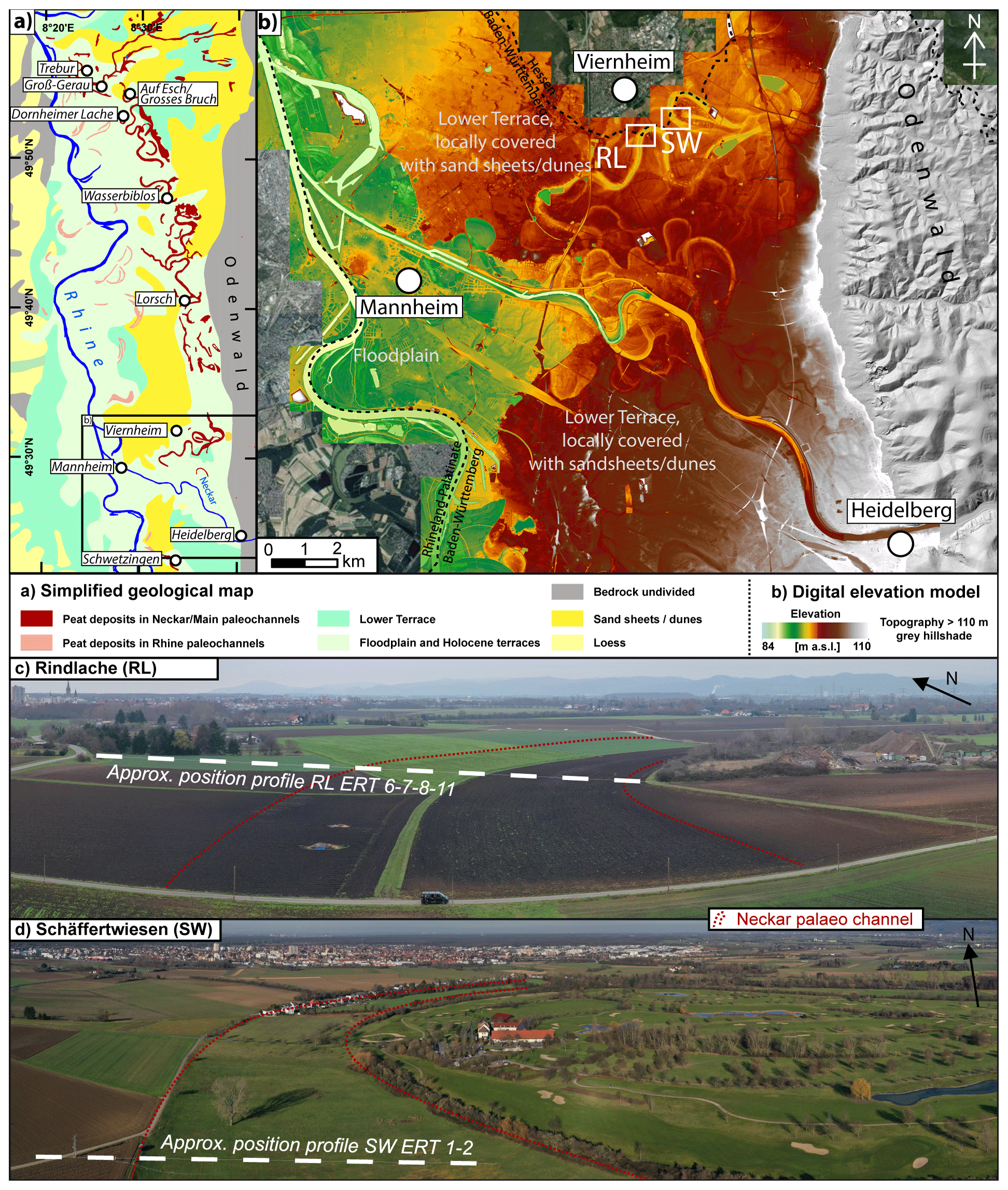
Figure 1Overview of the study area. (a) Simplified geological map of the northern Upper Rhine Graben based on the Geological Map of Germany 1:1 000 000 (GK1000) and, for the peat deposits, the General Geological Map of Germany 1:200 000 (GUEK200), sheets CC 6310 Frankfurt/Main – West and CC 7110 Mannheim. Data source: Bundesanstalt für Geowissenschaften und Rohstoffe (BGR). (b) High-resolution digital elevation model emphasising relief variation at 84–110 m NHN to highlight the active and abandoned fluvial channels of the BSN between Heidelberg and Mannheim. RL = Rindlache; SW = Schäffertwiesen. Data source: DGM1 of the Federal State of Baden-Württemberg provided by Landesamt für Geologie, Rohstoffe und Bergbau (LGBR) and established in 2000–2005. (c) Drone-based photograph of the Rindlache site (9 November 2020). (d) Drone-based photograph of the Schäffertwiesen site (17 January 2020).
Two palaeo-meanders were investigated at the field sites Rindlache (RL) and Schäffertwiesen (SW). The sites are located 1 km apart, ca. 15 km northwest of Heidelberg and ca. 10 km northeast of Mannheim, at the border between the German federal states of Baden-Württemberg and Hesse near Viernheim (Fig. 1b). The study area is part of the eastern Upper Rhine Graben and located between the river Rhine and the eastern graben shoulder, formed by the southern Odenwald with a Palaeozoic basement covered by (among others) Triassic Buntsandstein sandstone (Barsch and Mäusbacher, 1979, 1988; Nickel and Fettel, 1979; Eisbacher and Fielitz, 2010). Quaternary subsidence rates of the eastern Upper Rhine Graben near Heidelberg of ∼0.2 mm yr−1 are an order of magnitude higher compared to other parts of the graben and lead to high sedimentation rates and a thick late Quaternary infill (Peters and van Balen, 2007; Buness et al., 2009; Gabriel et al., 2013).
The study sites are located north of the alluvial fan of the Neckar, which forms where the river leaves the Odenwald and enters the surface of the last-glacial Lower Terrace inside the Upper Rhine Graben (Fig. 1b) (Barsch and Mäusbacher, 1979, 1988). In the northernmost part of the Upper Rhine Graben, the Lower Terrace is categorised into an upper Lower Terrace (t6, early to middle Würm) underlying the fluvial landscape of the northern BSN and a lower Lower Terrace (t7, late Würm) underlying the Rhine and its floodplain (Scheer, 1978; Dambeck, 2005; Erkens et al., 2009). In the area of the southern BSN no such distinction is made (Schottler, 1906; Kupfahl et al., 1972; Holzhauer, 2013). The Lower Terrace around the study sites shows varying ratios of sand and gravel, has an irregular surface, is cut by BSN channels, and is overlain by up to several metres of BSN-related sand- and silt-dominated flood deposits (Barsch and Mäusbacher, 1979; Löscher, 2007). During the late Pleistocene–Holocene transition, dunes formed on top of the silt- and sand-covered Lower Terrace (Löscher, 2007; Löscher et al., 1989) as elements of a larger regional dune system covering substantial parts of the northern Upper Rhine Graben (Dambeck, 2005; Holzhauer, 2013; Holzhauer et al., 2017; Pflanz et al., 2022).
The meandering course of the former BSN is reflected in the spatial distribution of peat deposits in Fig. 1a corresponding to morphological depressions of a depth of ∼2–4 m (Fig. 1b) (Barsch and Mäusbacher, 1979). The two study sites are situated in the most prominent palaeo-channels of the southern BSN (Fig. 1b) with distinct channel morphologies of inwardly convex and outwardly concave banks, and with diameters (half-meander path lengths sensu Howard and Hemberger, 1991) of 800–900 m. The two sites have been chosen as representative examples of (1) the presumably youngest course of the BSN (meander Rindlache) and (2) an earlier fluvial phase (cut-off meander Schäffertwiesen) (see maps in Mangold, 1892; Barsch and Mäusbacher, 1979) (Fig. 1b). The historical field names indicate that the sites were formerly used for pasture (Rind = cattle; Wiese = meadow) likely due to waterlogging (Lache = marsh/swamp) caused by a high groundwater table. The formerly high groundwater table in the Upper Rhine Graben has lowered significantly due to major regulation measures on the Neckar and Rhine since the early 19th century and subsequent river incision. More recently, the intensified exploitation of drinking and irrigation water added to groundwater level fall (see Barsch and Mäusbacher, 1979; Dister et al., 1990).
The stratigraphy at both sites was studied using 2-D electrical resistivity tomography (ERT) and sediment cores. ERT profiles were measured using a GeoTom MK1E100 device with Schlumberger configuration, 100 electrodes and 1 m spacing, as in Kneisel (2003). The composite ERT profile 6–7–8–11 at Rindlache consists of four separate profiles integrated with an overlap of 25 m (profiles 6–8) and 66 m (profiles 8 and 11), respectively. ERT profile 1–2 (112.5 m long) at Schäffertwiesen combines two separate profiles overlapping for 37.5 m. Post-processing of ERT data comprises the calculation of standard inversions without filtering using Res2Dinv software. Erroneous data points, e.g. resulting from disconnected electrodes during the measurement, were removed from the raw data prior to data modelling.
Along the ERT profiles, sediment cores were taken using a vibracorer and two different stainless-steel sampling tubes (Table S1 in the Supplement): (1) open percussion gouges (ø 6 cm) (Figs. S1, S2) and (2) closed percussion gouges equipped with PVC liner tubes (ø 5 cm) (Figs. S3–S7). Sediment cores taken in the open gouges were documented and sampled in the field according to Ad-hoc-AG Boden (2005) and the Munsell Soil Color Charts (Munsell Color Laboratory, 2000) (Table S2). The upper part of each core segment is prone to disturbances from material collapsing inside the borehole or from the recovery process. These disturbances were identified based on comparison with the lowermost part of the overlying core segment and removed from the record. The PVC liners were opened and the sediment documented (Munsell Color Laboratory, 2000; Ad-hoc-AG Boden, 2005) and sampled in the Laboratory for Geomorphology and Geoecology, Institute of Geography, Heidelberg University (Table S3). One additional core (RL01) was taken using an Edelman-type corer. At each site one core was analysed in more detail in the laboratory to support facies interpretation. All depths reported in the result section follow the original documentation and correspond to the core photographs in Figs. S1–S7. Additionally, adjusted depths of unit boundaries of the uppermost compressed metre are given in Tables S2 and S3. Samples were dried, carefully pestled by hand and sieved for the <2 mm fraction. Grain-size distributions of the <2 mm fraction were measured using a laser particle sizer (Fritsch Analysette P22) with a measurable range of 0.8–2000 µm at the Laboratory of Sedimentology, Institute of Geosciences, Heidelberg University. All samples were pre-treated with 10 mL H2O2 (30 %) to remove organic carbon and Na4P2O7 (55.7 g L−1) for aggregate dispersion. Univariate statistical measures were calculated using the Excel sheet GRADISTAT v9.1 (Blott and Pye, 2001). Organic matter was determined by loss-on-ignition (LOI) following a protocol slightly modified from Heiri et al. (2001). Samples of 3–5 g were combusted at 550 ∘C for 4 h in a muffle furnace. The carbonate content was measured using the Scheibler method according to DIN ISO 10693.
Four samples of autochthonous peat were dated by 14C accelerator mass spectrometry (AMS) at the Curt-Engelhorn-Centre Archaeometry in Mannheim, Germany. The absence of allochthonous root material was verified under a binocular microscope prior to sample submission to the dating laboratory. All samples were pre-treated with HCl, NaOH and HCl according to the acid–base–acid (ABA) method, during which the “base” step eliminates ex situ humic acids (Wild et al., 2013). The non-dissolved residual was then used for dating. The analysis was carried out on a MICADAS type AMS system (Kromer et al., 2013). Results were calibrated using CALIB 8.2 (Stuiver et al., 2022) and the IntCal20 dataset (Reimer et al., 2020). For age interpretation, the 2σ error was considered (Table S4). The reference date for all calibrated 14C data is 1950 CE.
The positions of all sediment cores and ERT electrodes, as well as topographic corrections, were determined using a Leica GS16 differential global navigation satellite system (DGNSS) and the satellite positioning service of the Federal State of Baden-Württemberg (SAPOS BW) in real-time kinematic (RTK) mode (lateral error: 1–2 cm; vertical error: 2–3 cm). Elevations are given in metres above NHN (Normalhöhen-Null: official vertical datum used in Germany signifying mean sea level in reference to Normaal Amsterdams Peil or Amsterdam Ordnance Datum) within the DHHN2016 (Deutsches Haupthöhennetz: official German height reference system, newly levelled and introduced in 2016–2017; AdV, 2018).
4.1 The Rindlache site
4.1.1 Stratigraphic record
Sediment core RL09 represents the stratigraphy of the BSN at Rindlache and was taken on a harvested crop field in the central part of the assumed palaeo-channel (Fig. 1b). The bottom unit of 5.45–5.20 m b.s. (below surface) is dominated by sand of changing colour and shows only minor amounts of silt and fine gravel (Figs. 2, S2). Between 5.20 and 4.50 m b.s., it is grain-supported, and coarser components of up to 5 cm (long axis) contribute up to >50 %. The sorting varies. The LOI values are very low, and the carbonate content is around 8 %. The section 4.50–2.30 m b.s. shows medium to coarse sand with lower amounts of coarser components and with improved sorting. The organic content is equally low, and the carbonate content decreases to 5 %–7 %. This unit is overlain by light greyish brown mud with upward-increasing carbonate content, culminating in a high value of >90 % in the uppermost part at 1.50 m b.s. Sand or coarser components are absent, whereas reddish brown vertical root casts are visible. Unfortunately, the lower boundary could not be identified due to core loss (2.30–2.00 m b.s.); however, it is abrupt in parallel core Gerd 1b (Fig. S3). The LOI values up to 1.36 m b.s. increase slightly to levels of 3 %–4 %. Above a sharp contact, black peat was found, most of which was lost during the core recovery (core loss: 1.30–1.00 m b.s.). The LOI values reach up to >40 %. In the parallel core Gerd 1b, peat from this unit at 1.05 m b.s. was dated to 6539–6402 cal yr BP (MAMS 43 986). The peat is overlain by dark grey, well-sorted organic-rich mud (0.92–0.80 m b.s.) showing LOI values of 13 %, a very low carbonate content and many fine roots. From 0.80 to 0.57 m b.s., the grey mud contains a few terrestrial gastropod shells and shell fragments, as well as some fine vertical roots. The carbonate content is slightly increased, whereas the LOI value is lower. Above this unit, the clayey silt has a light yellowish-brown colour, still containing gastropod shell fragments exhibited as higher carbonate content. The uppermost unit (0.46–0.15 m b.s.; for decompacted values see Table S3) is silt-dominated with increased LOI values representing the anthropogenically turbated plough horizon.
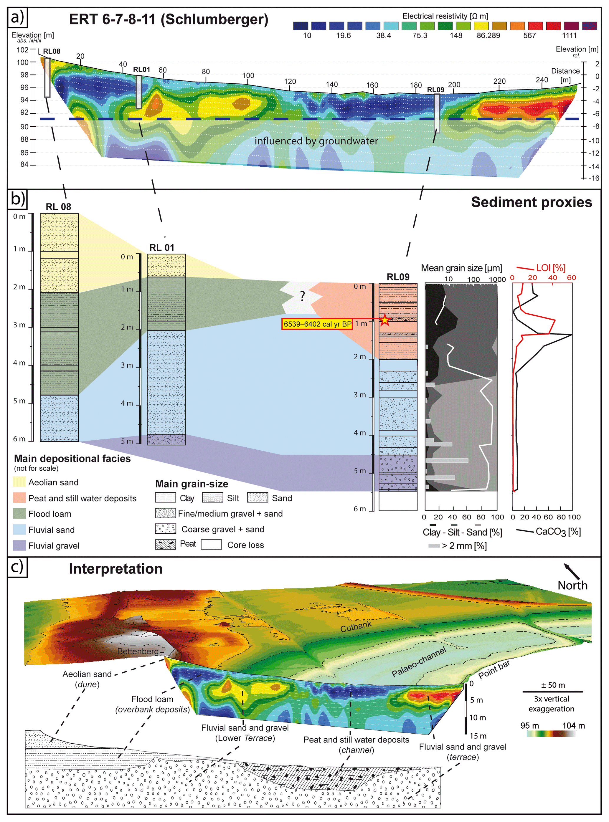
Figure 2BSN meander at Rindlache. (a) Transect ERT 6–7–8–11 crossing the palaeo-river channel and showing the distribution of fine-grained deposits in blue (low resistivity values) and coarse-grained deposits in green, yellow, brown and red (intermediate to high resistivity values). (b) Synopsis of sediment cores RL08, RL01 and RL09 with tentative facies interpretation. For RL09, grain-size distributions, mean grain size, LOI values and CaCO3 content are displayed. (c) Oblique view of the BSN meander in combination with the transect ERT 6–7–8–11 and tentative facies interpretation. A legend for the bottom drawing is provided in panel (b). Data source: DGM1 of the Federal State of Baden-Württemberg provided by LGBR and established in 2000–2005.
4.1.2 Electrical resistivity tomography (ERT)
The ERT profile 6–7–8–11 runs perpendicular to the BSN channel, indicated by a surface depression (Fig. 2a, c). It includes the flanks on both sides and intersects with core RL09 at 183 m horizontal distance (h.d.). In the northwest, the ERT profile starts at the foot of a late Pleistocene dune (Bettenberg, Fig. 2c; mapped in Barsch and Mäusbacher, 1979) at ca. 102 m NHN, running down a slightly concave slope with a small terrace bordering the outer bank at approximately 75–95 m h.d. It reaches the lowest elevations of the palaeo-meander channel at ca. 95 m NHN (ca. 125 to 210 m h.d.) and terminates at the inner bank of the palaeo-meander. The root mean square error (RMSE) is 4.1 % after three iterations of data modelling. The maximum difference in elevation across the entire profile is 6.5 m. The measured resistivity ranges between ∼10 and ∼1100 Ωm, and a depth of ca. 20 m b.s. was reached (Fig. 2a). The central channel between 125 and 210 m h.d. shows the lowest resistivity in the uppermost 4–6 m. This is in strong contrast to values which are an order of a magnitude higher at the southeastern end of the ERT profile between 210 and 260 m h.d. The slope at the foot of the Bettenberg dune also shows higher resistivities of 200–500 Ωm with a slightly thicker wedge of low-resistivity materials on top. Between 10 and 55 m h.d. this pattern is reversed, with ca. 1 m of medium resistivities (50–100 Ωm) at the top above very low resistivities, similar to the palaeo-meander channel infill.
4.2 The Schäffertwiesen site
4.2.1 Stratigraphic record
The sediment cores from Schäffertwiesen were taken along an ERT profile oriented perpendicular to the meander channel including the outer bank and a part of the channel (Figs. 1b, 3b, c). Sediment core SW01 was taken on the slope of the outer bank and reaches a depth of 4 m b.s. (Fig. S4). The lower part from 4.00 m to 1.74 m b.s. is characterised by a medium to coarse sand matrix and varying amounts of well-rounded gravel components, the latter mostly below 2.68 m b.s. This lowermost section is clast-supported between 3.45 m and 3.00 m b.s. (mostly limestone of Middle Triassic Muschelkalk, Upper Jurassic Weißjurakalk and red sandstone of Lower to Middle Triassic Buntsandstein, as well as other limestone and quartzite varieties). It shows increased carbonate content of up to 10 % and very low LOI values (<0.3 %). Between 2.75 m and 2.40 m b.s. some finer and darker laminae occur. From 2.40 m to 2.00 m b.s., the core is disturbed by collapsed material. A sharp boundary separates the sand to gravel deposits from sandy to clayey mud (1.74–0.84 m b.s.), where LOI values increase to up to 6 %, and carbonate content reaches up to 25 %. A thin sand layer resembling the bottom facies is intercalated at 1.61–1.57 m b.s. Plant remains from a depth of 1.67 m b.s. were dated to 11 258–11 195 cal yr BP (MAMS 46037). The carbonate-rich mud is overlain by peat (0.84–0.59 m b.s.) with LOI values of up to 57 % and a very low carbonate content of <1 %. Peat-derived 14C data range from 11 079–10 722 cal yr BP (0.80 m b.s., MAMS 46036) to 7920–7701 cal yr BP (0.60 m b.s., MAMS 46035). This peat section is separated from the organic-rich topsoil (0.28–0.11 m b.s.; LOI values up to 24 %) by a brownish grey sandy mud section.
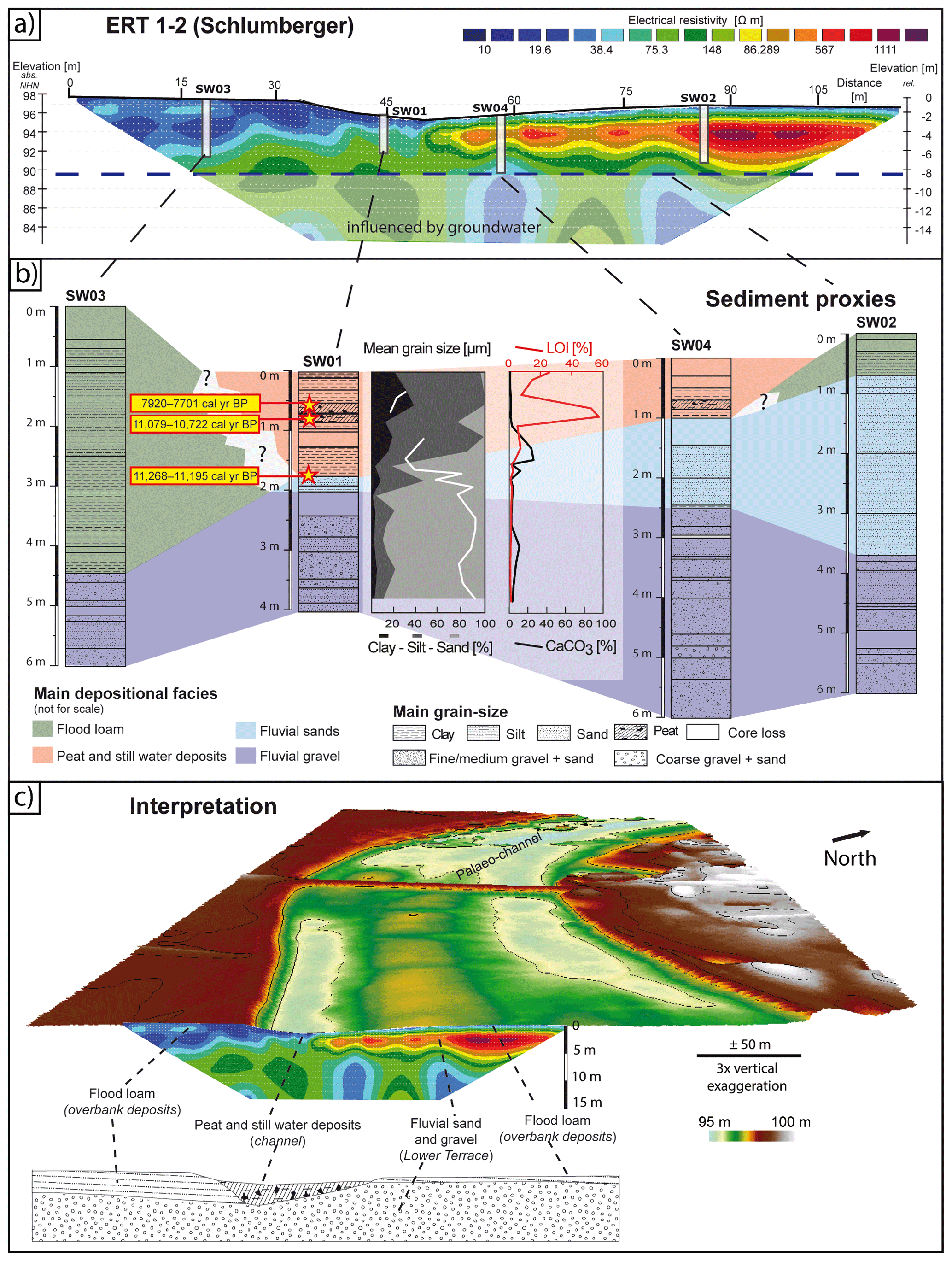
Figure 3BSN meander at Schäffertwiesen. (a) Transect ERT 1–2 crossing the palaeo-river channel and showing the distribution of fine-grained deposits in blue (low resistivity values) and coarse-grained deposits in green, yellow, brown and red (intermediate to high resistivity values). (b) Synopsis of sediment cores SW03, SW01, SW04 and SW02 with tentative facies interpretation. For SW04, grain-size distributions, mean grain size, LOI values and CaCO3 content are displayed. (c) Oblique view of the BSN meander in combination with the transect ERT 6–7–8–11 and tentative facies interpretation. A legend for the bottom drawing is provided in panel (b). Data source: DGM1 of the Federal State of Baden-Württemberg provided by LGBR and established in 2000–2005.
The coarse sand and gravel unit was found in the basal parts of all cores from Schäffertwiesen, where it varies in thickness (Fig. 3b). Its sharp upper boundary rises from 93.11 m NHN in the west (SW03) to 93.72 m b.s. (SW01), 94.22 m b.s. (SW04) and 96.17 m b.s. (SW02) in the east. The overlying poorly sorted sandy mud from SW01 (1.74–0.84 m b.s.) was not found in SW02 and SW04 but can be correlated with a much thicker occurrence in the western part of the profile (SW03; 4.45–0.55 m b.s.). The peat, however, is only present in SW04, close to the top of the sequence, in similar thickness as observed in SW01.
4.2.2 Electrical resistivity tomography (ERT)
The stratigraphic correlations between the cores are reflected by the ERT profile 1–2 at Schäffertwiesen (Fig. 3a). It has a length of 112.5 m and an RMS error of 3.9 % after three iterations of data modelling. Resistivity values are in the same range as in ERT profile 6–7–8–11 at Rindlache. From its southwestern end, the profile traverses over a flat terrace for ca. 30 m at ca. 98 m NHN before following a concave slope down to ca. 95.5 m NHN in the lowest part of the profile, which is also where core SW01 was taken. Between 45 m h.d. and the northeastern end, the profile gradually rises in the form of a slightly convex slope to ca. 96.5 m NHN. The flat part of the profile in the southwest, represented by core SW03, shows very low resistivity values (10–40 Ωm) correlating with the sandy mud facies. Here, resistivity only increases below ca. 5 m b.s., where the sand and gravel deposits were encountered in SW03. Likewise, in the topographically lowest part of the profile, corresponding to SW01, the basal sand and gravel deposits are reflected by medium resistivity values of around 80 Ωm, compared to 20–50 Ωm in the sandy mud and peat of the uppermost 1.70 m of the sequence. In the northeastern part of the profile, medium to high resistivity values reach close to the surface, following the rising boundary between the sand and gravel unit and the peat.
5.1 Fluvial activity as reconstructed from facies patterns
The sand and gravel deposits found in the basal part of all cores from both palaeo-meander sites consist of varying ratios of predominantly medium to coarse sand and rounded to well-rounded gravel components. They represent the bedload of the BSN deposited at the bottom of the formerly active meander channel. Primary deposition of the material in pre-late-glacial times, perhaps in a braided system in Pleniglacial times of the last-glacial period, and subsequent reworking of these deposits in late-glacial times by a single meandering channel is plausible. As the channels are incised into the Lower Terrace of the Rhine, it is possible that Rhine deposits were reactivated by the BSN. Although a quantitative petrographic analysis to discriminate between Rhine and Neckar deposits is still pending, the visual inspection of basal gravel components in both master cores RL09 and SW01 already shows a dominance of Muschelkalk, Weißjura and other limestones, as well as Buntsandstein sandstone, collectively representing the main erosional products of the Neckar catchment (Barsch and Mäusbacher, 1979; Fezer, 1997; Bibus and Rähle, 2003; Löscher, 2007; LGBR, 2021). These deposits shape the youngest part of the wide alluvial fan of the Neckar (Löscher et al., 1980; Barsch and Mäusbacher, 1988), which belongs to the Mannheim Formation (LGBR, 2021) and, at its northern boundary, almost reaches the study area (Fezer, 1997; Beckenbach, 2016).
The typical sediment sequence of palaeo-meander channels of the northern BSN (e.g. site of “Wasserbiblos” in Dambeck, 2005; Dambeck and Bos, 2002) also starts with fluvial sands and few pebbles. The general fining-up gradient from a sand and gravel mixture (in the southern BSN with some clast-supported sections) to matrix-supported units and pure fluvial sands indicates a decrease in fluvial transport capacity at the end of the phase of fluvial activity of the BSN. This decrease is either related to lower discharge or a thalweg shifting away from the coring site. However, it cannot be excluded that the increasing medium sand component in the upper part of the fining-up sequence is partially related to reactivated aeolian processes and input during the Younger Dryas (Löscher et al., 1989; Dambeck and Thiemeyer, 2002; Pflanz et al., 2022). The poorly sorted greyish-brown sandy mud overlying the in-channel fluvial sands in RL09 (boundary at 2.30 m b.s.) and SW01 (boundary at 1.74 m b.s.) reflects a distinct shift from a fluvial channel carrying bedload – until then presumably the main active channel of the BSN – to a cut-off channel restricted to suspension-load settling during stages of overbank flow by an adjacent active channel (Barsch and Mäusbacher, 1979). At Schäffertwiesen, this adjacent channel was the Rindlache channel. After the BSN was entirely abandoned, the Rindlache site was subject to flooding and received suspension load from a new Neckar course close by. This might have been the current channel heading straight to the Rhine near Mannheim, although this assumption requires verification with future research. Along the northern BSN this type of fluvio-limnic deposition is observed for the older meander generation before peat formation commenced, whereas at the younger meander sites peat deposits immediately overlie the coarse-grained channel-bottom deposits (Dambeck, 2005; Dambeck and Bos, 2002). Thus, the sedimentary sequences at Rindlache and Schäffertwiesen both resemble the infill of the older meander sites along the northern BSN. At some palaeo-channel sites of the northern BSN (e.g. “Auf Esch”, “Großes Bruch”), as well as at Rindlache, peat formation is interrupted by organic-rich black clays that may represent a reactivation of overbank deposition and indicate increased input of fine-grained material into the inactive fluvial system (Dambeck, 2005; Dambeck and Thiemeyer, 2002).
Dambeck and Bos (2002) and Dambeck and Thiemeyer (2002) refer to the sandy mud overlying the fluvial channel-bottom facies at the older meander sites as clays, silts, loam or gyttja with occasional fine sandy laminae, depending on the site. The very high carbonate content in the uppermost part of this fine-grained unit (>90 % in RL09) right below the overlying peat, also referred to as calcareous gyttja along the northern BSN (Dambeck and Bos, 2002; Bos et al., 2008), was identified as secondary carbonate precipitation. At present, two models for the formation of this carbonate precipitation are considered.
-
The first is precipitation within the sediment body at distinct substrate boundaries in the groundwater fluctuation zone, along the capillary fringe, as described for the so-called Rheinweiß in similar contexts (Dambeck, 2005; Holzhauer, 2013; Holzhauer et al., 2017). Being this close to the present-day land surface, the Rheinweiß represents a relict feature. It predates the river regulation measures in the Upper Rhine Graben from 1817 CE on that led to rapid linear incision of the Rhine and to lowering of groundwater levels by several metres in the entire graben area (Barsch and Mäusbacher, 1979; Dister et al., 1990).
-
The second is precipitation in the fluvio-limnic environment of the cut-off meander by photosynthesising Charophyceae and aquatic plants, aided by the uptake of CO2 from bicarbonate () dissolved in the water (e.g. Bohnke and Hoek, 2007). The general model, according to which carbonate ions () are released and attract Ca2+ ions to form Ca2CO3 in the immediate vicinity of the photosynthesising organisms, is described in, for example, Merz (1992).
Whilst in both the southern and the northern (site “Wasserbiblos” in Dambeck and Bos, 2002) parts of the BSN these calcareous muds mostly date into the Preboreal (11.7–10.3 kyr ago) (Fig. 4), they are also well recognised to have formed earlier during the Alleröd (13.4–12.7 kyr ago) elsewhere in Central Europe (e.g. Bohncke and Hoek, 2007; Pawłowski et al., 2016). They may in general be associated with warmer phases of the late-glacial to Holocene transition with more abundant (aquatic) vegetation, shifting the carbonate balance and leading to increased carbonate precipitation (Waldmann, 1989; Dambeck, 2005).
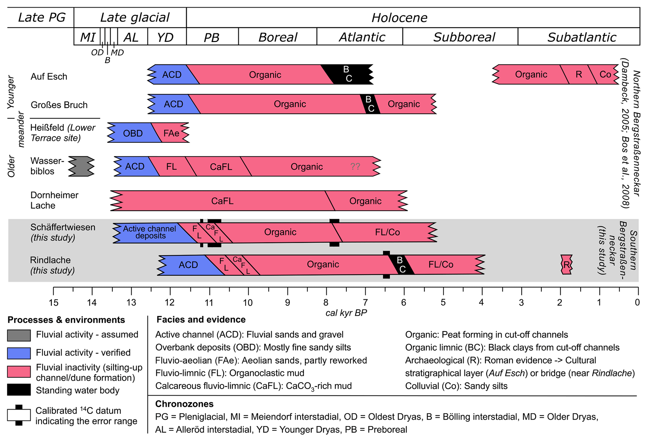
Figure 4Assumed timeline of fluvial activity and inactivity of the Bergstraßenneckar (BSN). All sites refer to profiles from palaeo-channels, apart from Heißfeld (profile on the Lower Terrace adjacent to a BSN palaeo-channel). Results from the northern BSN (upper part) were taken from Dambeck (2005) and Bos et al. (2008). Preliminary data and interpretation from the southern BSN (this study) are shown in the lower part on the grey background. Wetland or temporary standing-water conditions at Rindlache during Roman times are inferred from the partially excavated wooden bridge across the same BSN channel ca. 1 km to the south (Wirth, 2011).
5.2 Timing of fluvial activity of the southern BSN
There are diverging assumptions regarding the timing of the fluvial activity of the BSN. Its relatively short existence has been associated with the late-glacial formation of the north–south-directed dune belt between Schwetzingen and Lorsch (Fig. 1a) (e.g. Dambeck, 2005), which is assumed to have blocked the direct connection with the Rhine between Heidelberg and Mannheim. Yet, none of the palaeo-channels of the northern BSN are covered by any significant drift sands, the formation of which terminated mostly before the Older Dryas (13.6–13.4 kyr ago). Instead, drift sands were eroded by the BSN in some places, indicating that fluvial activity postdates the period of main aeolian activity. Initial activity of the BSN is tentatively dated to ca. 14 500 years ago (Dambeck, 2005). At the site “Fasanerie” near Groß-Gerau (Dambeck, 2005) and near Schwanheim (Hoffmann and Kzyzanowski, 1984) (Fig. 1a), Laacher See tephra, now dated to 13 006±9 cal yr BP (Reinig et al., 2021), was identified in overbank deposits of the northern BSN. The detailed stratigraphic investigations in the northern part of the BSN indicate a dune breach of the Neckar towards the Rhine at approximately 12 800 to 11 500 years ago during the Younger Dryas (12.7–11.7 kyr ago) and an end to fluvial activity of the BSN channels at some point between ca. 11 600 and 10 120 years ago (Haupt, 1928; Wagner, 1981; Große-Brauckmann et al., 1990; Dambeck, 2005; Dambeck and Bos, 2002; Bos et al., 2008, 2012). However, there are several historical accounts and archaeological data pointing to the reactivation of certain sections of the BSN by smaller tributaries draining the western Odenwald Mountains and their use as waterways for the transport of goods, in particular during Roman times (Eckoldt, 1985; Wirth, 2011).
For the northern BSN, two palaeo-meander generations have been classified. Whilst the relatively younger meander generation forms a more or less continuous course to the former mouth west of Trebur, the relatively older meanders are morphologically detached (Kupfahl et al., 1972; Dambeck, 2005). Based on palynostratigraphical evidence and radiocarbon data, mud deposition in cut-off meanders of the older generation started in Alleröd times (site “Dornheimer Lache” in Bos et al., 2008) or by the end of the Younger Dryas (site “Wasserbiblos” in Dambeck, 2005; Dambeck and Bos, 2002; Bos et al., 2012). Elsewhere, it is assumed that sands were blown out from the inactive point bars of cut-off meanders to form proximal dunes on the Lower Terrace (HLfB, 1990), e.g. at the site “Heißfeld” (Dambeck, 2005; Dambeck and Thiemeyer, 2002) at a time, during the Younger Dryas, when aeolian dunes and drift sands of the northern Upper Rhine Graben were reactivated to a limited extent (Löscher et al., 1989; Dambeck and Bos, 2002; Pflanz et al., 2022). The younger meander sites show a distinct shift from fluvial sands to peat growth roughly at the beginning of the Preboreal (Fig. 4), possibly reflecting the abandonment of the BSN and confluence of the Neckar with the Rhine further to the south near Mannheim (Dambeck, 2005).
The basic stratigraphic patterns of the northern and southern BSN show striking similarities, but presently, very few radiocarbon ages are available for the southern BSN. However, if these are used as chronometric tie points as illustrated in Fig. 4 (lower part), the similarities become even more obvious. As the clastic mud deposits at the site Schäffertwiesen may date to the Younger Dryas to Preboreal period, we assume that the coarse-grained channel-bottom deposits underneath date to late-glacial times. The shift from mud sedimentation to peat growth may have been induced by a denser vegetation cover at the onset of the Preboreal (Dambeck and Bos, 2002; Bos et al., 2008) leading to reduced suspension load during flood events and termination of the silting-up process. At the site “Wasserbiblos”, northern BSN, sedimentation of similar silty and calcareous mud, reflecting a change in fluvial conditions from in-channel bedload transport and accumulation at the channel bottom to fluvio-limnic conditions inside a cut-off meander, is also dated to the end of the late-glacial period. A temporal overlap of changing fluvial dynamics at the Schäffertwiesen meander (between 12 000 and 11 500 cal yr BP) at the southern BSN and the older meander generation at the northern BSN, represented by the site “Wasserbiblos” (Dambeck, 2005; Dambeck and Bos, 2002; Bos et al., 2012), is likely. Yet peat formation at the northern BSN started earlier, during Preboreal times, and lasted until the end of the Boreal or beginning of the Atlantic period (ca. 8000–7500 cal yr BP). The peat at Rindlache continued to form until ca. 1500 years later (ca. 6500–6000 cal yr BP) (Fig. 4). The deposition of organic-rich black clays inside the channels and as overbank fines during the Atlantic period may represent an initial signal of anthropogenic soil erosion by Middle Neolithic communities (Große-Brauckmann et al., 1990; Dambeck and Thiemeyer, 2002). This interpretation is supported by the first occurrence of Cerealia in pollen spectra of northern BSN sites as an indicator of the introduction of agriculture and a decrease of Ulmus, which is related to the Neolithic Linear Pottery and Rössen cultures using this type of wood for fire and construction (Bos et al., 2012). In the area of the southern BSN people of the Late Neolithic Michelsberg (ca. 4400–3500 BCE; Lang, 1996) and/or the end Neolithic Corded Ware ceramic cultures (ca. 2900–2350 BCE; König, 2015) may have intensified soil erosion resulting in a subsequent increase in suspension load and the formation of the black clays.
Assuming that the Rindlache site – in contrast to the cut-off meander of Schäffertwiesen – represented the active channel until the modern Neckar channel was established and the BSN finally abandoned, the entire chronostratigraphy may be offset by ca. 1500 years. Thus, it would overlap with the chronostratigraphy of northern BSN sites representing the younger meander generation, sensu Dambeck (2005), even though the Rindlache site shows an interim sequence of fluvio-limnic sandy mud, which in the north is characteristic of only older meander sites (Fig. 4).
Palaeo-meanders of the southern BSN are an understudied geomorphological archive. This is all the more surprising as studies along the northern BSN in Hesse proved to reveal detailed aspects of the late-glacial to Holocene history of the Upper Rhine Graben riverscape (e.g. Dambeck, 2005; Dambeck and Thiemeyer, 2002; Bos et al., 2008). The palaeo-meander channels of the southern BSN can still be morphologically identified in the field, as well as from satellite imagery and digital elevation models (Beckenbach, 2016), representing a sequence of relatively older meanders which have been cut off from younger channels. Our pilot study at the relatively older Schäffertwiesen meander and the younger Rindlache meander shows a stratigraphic sequence reaching from partially clast-supported sand and gravel in-channel facies to muds and peat representing the phase after which the meanders were cut off, and the Neckar shifted its course entirely. The 14C data of the upper boundaries of the peat deposits at both sites, Schäffertwiesen (cut-off meander) and Rindlache (part of the latest course), are offset by ca. 1500 years, reflecting the overall older age of the Schäffertwiesen sequence. In comparison with the abandoned riverscape of the northern BSN (Dambeck, 2005), both sites studied here resemble the stratigraphic pattern of the older meander phase with fluvio-limnic mud deposition which is vertically confined by coarse-grained in-channel facies (below) and peat and black clays (above). The chronology of the Schäffertwiesen site tentatively correlates with the older meander generation, while the Rindlache site has more of a chronological overlap with the younger meander generation of the northern BSN, where, however, the intermittent mud is absent. Therefore, the presence of fluvio-limnic sediments in the abandoned river channel may be a function of flooding frequency and proximity to a still active channel. Whilst this was the case for both of the southern sites after the final abandonment of the BSN as they were still close to the new Neckar course, the northern BSN channel sites were cut off from a regular flooding regime.
Evidently, more palaeo-channel stratigraphies of the southern BSN need to be investigated and correlated, in combination with an extended chronological dataset of 14C ages for the organic-rich sediments and optically stimulated luminescence ages for the sand-dominated in-channel facies, for which no data are available to date. In particular, the palaeoenvironments of the fluvio-limnic muds, along with any potential anthropogenic impact, require further attention and need to be reconstructed in more detail. Deciphering a chronology of fluvial activity in the southern BSN domain will provide the basis for investigating the reactivation of some reaches of and human interaction with the BSN across the Holocene, in particular during Roman times and later historical periods, for which only fragmented historical and archaeological information is available so far (e.g. Eckoldt, 1985).
All data from this study can be found in the Supplement.
The supplement related to this article is available online at: https://doi.org/10.5194/egqsj-71-213-2022-supplement.
The concept of the study was jointly developed by all authors at the Institute of Geography, Heidelberg University, in the context of field courses held at the two study sites. All these authors were involved in the fieldwork. Sedimentary laboratory analyses were carried out by FR, GS and ME. FR contributed results from his master of science thesis. Processing and analysis of ERT data were carried out by MH, FH and SH. The GIS for this project was set up by FH. SL performed the 14C dating. A first draft of the manuscript was written by ME, FH and AK. ME, FH, FR, AK, MH, SH, SL and OB commented on and approved the manuscript.
The contact author has declared that none of the authors has any competing interests.
Publisher’s note: Copernicus Publications remains neutral with regard to jurisdictional claims in published maps and institutional affiliations.
This article is part of the special issue “Quaternary research from and inspired by the first virtual DEUQUA conference”.
We thank Peter Müller (Mannheim-Straßenheim) and the Bach family (Heddesheim) for permission to conduct fieldwork on their properties. Undergraduate students of the geography programmes at Heidelberg University are thanked for their engagement during field courses. Nicola Manke kindly provided support during one field course and during the laboratory analyses. Support and permission to use the laser particle sizer of the Sedimentology and Marine Paleoenvironmental Dynamics research group at the Institute of Geosciences at Heidelberg University by Andre Bahr are greatly appreciated. Finally, we would like to thank the Landesamt für Geologie, Rohstoffe und Bergbau (LGBR) for providing the digital elevation model DGM1 of the state of Baden-Württemberg. We are thankful for the helpful reviews of one anonymous person and of Rainer Dambeck, who provided highly detailed comments, plenty of ideas and improved the manuscript by sharing his great regional expertise.
Gerd Schukraft was a driving force of the research on the southern Bergstraßenneckar and one of the initiators back in 2019. He sadly passed away in April 2020.
This research was supported by funds of Heidelberg University. For the publication fee we acknowledge financial support by Deutsche Forschungsgemeinschaft within the funding programme “Open Access Publikationskosten”, as well as by Heidelberg University.
This paper was edited by Julia Meister and reviewed by Rainer Dambeck and one anonymous referee.
Ad-hoc-AG Boden: Bodenkundliche Kartieranleitung, 5th edn., Schweizerbart, Hannover, 438 pp., 2005.
AdV (Arbeitsgemeinschaft der Vermessungsverwaltungen der Länder der Bundesrepublik Deutschland): DHHN2016 – Die Erneuerung des Deutschen Haupthöhennetzes und der einheitliche integrierte geodätische Raumbezug 2016, Landesamt für Digitalisierung, Breitband und Vermessung Bayern, München, 2018.
Barsch, D. and Mäusbacher, R.: Erläuterungen zur Geomorphologischen Karte 1:25 000 der Bundesrepublik Deutschland – GMK 25 Blatt 3, 6417 Mannheim-Nordost, in: GMK Schwerpunktprogramm, Geomorphologische Detailkartierung in der Bundesrepublik Deutschland, edited by: Barsch, D., Fränzle, O., Leser, H., Liedtke, H., and Stäblein, G., Berlin, 1–56, 1979.
Barsch, D. and Mäusbacher, R.: Zur fluvialen Dynamik beim Aufbau des Neckarschwemmfächers, Berlin. Geogr. Abh., 47, 119–128, https://doi.org/10.23689/fidgeo-3194, 1988.
Beckenbach, E.: Geologische Interpretation des hochauflösenden digitalen Geländemodells von Baden-Württemberg, PhD thesis, University of Stuttgart, Germany, https://doi.org/10.18419/opus-8846, 2016.
Bernhard, H. and Hickethier, H.: Beitrag zur Kenntnis des alten Neckarlaufs am Westrand des Odenwalds bei Bensheim, Notizbl. Hess. L.-Amt Bodenforsch., 94, 385–389, 1966.
Bibus, E., and Rähle, W.: Stratigraphische Untersuchungen an molluskenführenden Terrassensedimenten und ihren Deckschichten im mittleren Neckarbecken (Württemberg), E&G Quaternary Sci. J., 53, 94–113, https://doi.org/10.3285/eg.53.1.06, 2003.
Blott, S. J., and Pye, K.: GRADISTAT: a grain size distribution and statistics package for the analysis of unconsolidated sediments, Earth Surf. Proc. Landf., 26, 1237–1248, https://doi.org/10.1002/esp.261, 2001.
Bohncke, S. J. P. and Hoek, W. Z.: Multiple oscillations during the Preboreal as recorded in a calcareous gyttja, Kingbeekdal, The Netherlands, Quaternary Sci. Rev., 26, 1965–1974, https://doi.org/10.1016/j.quascirev.2007.02.017, 2007.
Bos, J. A. A., Dambeck, R., Kalis, A. J., Schweizer, A., and Thiemeyer, H.: Palaeoenvironmental changes and vegetation history of the northern Upper Rhine Graben (southwestern Germany) since the Lateglacial, Neth. J. Geosci., 87, 67–90, https://doi.org/10.1017/S0016774600024057, 2008.
Bos, J. A. A., Dambeck, R., and Bouman, M. I. T. J.: Paläoökologische Untersuchungen im nördlichen Oberrheingraben vom Spätglazial bis Atlantikum; Vegetationsgeschichte und anthropogene Einflüsse, Frankfurt. Archäol. Schr., 18, 59–90, 2012.
Buness, H., Gabriel, G., and Ellwanger, D.: The Heidelberg Basin drilling project: Geophysical pre-site surveys, E&G Quaternary Sci. J., 57, 338–366, https://doi.org/10.3285/eg.57.3-4.4, 2009.
Dambeck, R.: Beiträge zur spät- und postglazialen Fluss- und Landschaftsgeschichte im nördlichen Oberrheingraben, PhD thesis, University of Frankfurt/Main, Germany, 438 pp., 2005.
Dambeck, R. and Bos, J. A. A.: Lateglacial and Early Holocene landscape evolution of the northern Upper Rhine River valley, south-western Germany, Z. Geomorph. Suppl., 128, 101–127, 2002.
Dambeck, R., and Thiemeyer, H.: Fluvial history of the northern Upper Rhine River (southwestern Germany) during the Lateglacial and Holocene times, Quaternary Int., 93, 53–63, https://doi.org/10.1016/S1040-6182(02)00006-X, 2002.
Dister, E., Gomer, D., Obrdlik, P., Petermann, P., and Schneider, E.: Water management and ecological perspectives of the upper Rhine's floodplains, Regul. River., 5, 1–15, https://doi.org/10.1002/rrr.3450050102, 1990.
Eckoldt, M.: Schiffahrt auf kleinen Flüssen. T. 2, Gewässer im Bereich des “Odenwaldneckars” im ersten Jahrtausend n. Chr., Deutsch. Schiffahrtsarch., 8, 101–116, 1985.
Eisbacher, G. H. and Fielitz, W.: Karlsruhe und seine Region. Nordschwarzwald, Kraichgau, Neckartal, südlicher Odenwald, Oberrhein-Graben, Pfälzerwald und westliche Schwäbische Alb. Sammlung Geologischer Führer Vol. 103, Bornträger, Stuttgart, 2010.
Erkens, G., Dambeck, R., Volleberg, K. P., Bouman, M. T., Bos, J. A., Cohen, K. M., Wallinga, J., and Hoek, W. Z.: Fluvial terrace formation in the northern Upper Rhine Graben during the last 20 000 years as a result of allogenic controls and autogenic evolution, Geomorphology, 103, 476–495, https://doi.org/10.1016/j.geomorph.2008.07.021, 2009.
Fezer, F.: 220 m Altpleistozän im “Heidelberger Loch”, E&G Quaternary Sci. J., 47, 145–153, https://doi.org/10.3285/eg.47.1.10, 1997.
Gabriel, G., Ellwanger, D., Hoselmann, C., Weidenfeller, M., Wielandt-Schuster, U., and The Heidelberg Basin Project Team: The Heidelberg Basin, Upper Rhine Graben (Germany): A unique archive of Quaternary sediments in Central Europe, Quaternary Int., 292, 43–58, https://doi.org/10.1016/j.quaint.2012.10.044, 2013.
Große-Brauckmann, G., Malchow, G., and Streitz, B.: Makrofossil- und pollenanalytische Befunde vom Altneckarbett bei Riedstadt-Goddelau, in: Die Holzbrücken bei Riedstadt-Goddelau, Kreis Groß-Gerau, edited by: Wagner, P., Mater. Vor- u. Frühgesch. Hessen, 5, 111–132, 1990.
Haupt, O.: Die Pfahlbausiedlung am Phillipshospital bei Goddelau im hessischen Ried sowie das Alter der Neckarbetten und des Modauschuttkegels an der Bergstraße, Notizbl. Ver. Erdk. Hess. Geol. L.-Anst., V(10), 239–245, 1928.
Heiri, O., Lotter, A. F., and Lemcke, G.: Loss on ignition as a method for estimating organic and carbonate content in sediments: reproducibility and comparability of results, J. Paleolimnol., 25, 101–110, https://doi.org/10.1023/A:1008119611481, 2001.
HLfB (Hessisches Landesamt für Bodenforschung): Bodenkarte der nördlichen Oberrheinebene 1:50000, Wiesbaden, 1990.
Hoffmann, J. and Krzyzanowski, J.: Laacher-Bimstuff-Vorkommen im Bereich des ehemaligen Neckarlaufs bei Zwingenberg (Bergstraße), Geol. Jb. Hessen, 112, 77–81, 1984.
Holzhauer, I.: Landschaftsgeschichte und menschlicher Einfluss im Umfeld der Schwetzinger Hardt seit dem Würm-Hochglazial, PhD thesis, Heidelberg University, Germany, https://doi.org/10.11588/heidok.00015714, 2013.
Holzhauer, I., Kadereit, A., Schukraft, G., Kromer, B., and Bubenzer, O.: Spatially heterogeneous relief changes, soil formation and floodplain aggradation under human impact – geomorphological results from the Upper Rhine Graben (SW Germany), Z. Geomorph., 61 (Suppl. 1), 121–158, https://doi.org/10.1127/zfg_suppl/2017/0357, 2017.
Howard, A. D. and Hemberger, A. T.: Multivariate characterization of meandering, Geomorphology, 4, 161–186, https://doi.org/10.1016/0169-555X(91)90002-R, 1991.
Kneisel, C.: Electrical resistivity tomography as a tool for geomorphological investigations – some case studies, Z. Geomorph. Suppl., 132, 37–49, 2003.
König, P.: Eine vorgeschichtliche und frühmittelalterliche Siedlung von Heddesheim, Rhein-Neckar-Kreis, Fundber. Baden-Württemb., 35, 141–204, https://doi.org/10.11588/fbbw.2015.0.44523, 2015.
Kromer, B., Lindauer, S., Synal, H. A., and Wacker, L.: MAMS – a new AMS facility at the Curt-Engelhorn-Centre for Achaeometry, Mannheim, Germany, Nucl. Instr. Meth., 294, 11–13, https://doi.org/10.1016/j.nimb.2012.01.015, 2013.
Kupfahl, H.-G., Meisl, S., and Kümmerle, E.: Erläuterungen zur geologischen Karte von Hessen 1:25000, Blatt 6217 Zwingenberg an der Bergstraße, Hessisches Landesamt für Bodenforschung, Wiesbaden, 276 pp., 1972.
Lang, A.: Die Infrarot-Stimulierte-Lumineszenz als Datierungs- methode für holozäne Lössderivate. Ein Beitrag zur Chronometrie kolluvialer, alluvialer und limnischer Sedimente in Südwestdeutschland, Heidelb. Geogr. Arb., 103, 1–137, 1996.
LGBR (Landesamt für Geologie, Bergbau und Rohstoffe): Kiese und Sande des Neckars im Oberrheingraben, https://lgrbwissen.lgrb-bw.de/rohstoffgeologie/rohstoffe-des-landes/kiese-sandig/kiese-sande-des-neckars-im-oberrheingraben, last access: 27 August 2021.
Löscher, M.: Die quartären Ablagerungen auf der Mannheimer Gemarkung, in: Mannheim vor der Stadtgründung. Teil 1 Band 1, edited by: Probst, H., Friedrich Pustet Verlag, Regensburg, 28–47, 2007.
Löscher, M., Haag, T., and Münzing, K.: Zum Alter der Dünen im nördlichen Oberrheingraben bei Heidelberg und zur Genese ihrer Bänderparabraunerden, E&G Quaternary Sci. J., 39, 98–108, https://doi.org/10.3285/eg.39.1.10, 1989.
Löscher, M., Becker, B., Bruns, M., Hieronymus, U., Mäusbacher, R., Münnich, M., Münzing, K., and Schedler, J.: Neue Ergebnisse über das Jungquartär im Neckarschwemmfächer bei Heidelberg, E&G Quaternary Sci. J., 30, 89–100, https://doi.org/10.3285/eg.30.1.07, 1980.
Mangold, A.: Die alten Neckarbetten in der Rheinebene, Abh. Großherzogl. Hess. Geol. Landesanst. Darmstadt, 2, 75–114, 1892.
Merz, M. U. E.: The biology of carbonate precipitation by cyanobacteria, Facies, 26, 81–102, https://doi.org/10.1007/BF02539795, 1992.
Mone, F. J.: Ueber den alten Flußlauf im Oberrheintal, Badisch. Arch. z. Vaterlandsk. in allseit. Hinsicht, 1, 1–47, 1826.
Munsell Color Laboratory: Munsell Soil Color Chart, New Windsor, 2000.
Nickel, E. and Fettel, M.: Odenwald – Vorderer Odenwald zwischen Darmstadt und Heidelberg, Sammlung Geologischer Führer Vol. 65, Bornträger, Stuttgart, 1979.
Pawłowski, D., Borówka, R. K., Kowalewski, G. A., Luoto, T. P., Milecka, K., Nevalainen, L., Okupny, D., Tomkowiak, J., and Zieliński, T.: Late Weichselian and Holocene record of the paleoenvironmental changes in a small river valley in Central Poland, Quaternary Sci. Rev., 135, 24–40, https://doi.org/10.1016/j.quascirev.2016.01.005, 2016.
Peters, G. and van Balen, R. T.: Tectonic geomorphology of the northern Upper Rhine Graben, Germany, Global Planet. Change, 58, 310–334, https://doi.org/10.1016/j.gloplacha.2006.11.041, 2007.
Pflanz, D., Kunz, A., Hornung, J., and Hinderer, M.: New insights into the age of aeolian sand deposition in the northern Upper Rhine Graben (Germany), Quaternary Int., 625, 1–13, https://doi.org/10.1016/j.quaint.2022.03.019, 2022.
Reimer, P. J., Austin, W. E., Bard, E., Bayliss, A., Blackwell, P. G., Ramsey, C. B., and Grootes, P. M.: The IntCal20 northern hemisphere radiocarbon age calibration curve (0–55 cal kBP), Radiocarbon, 62, 725–757, https://doi.org/10.1017/RDC.2020.41, 2020.
Reinig, F., Wacker, L., Jöris, O., Oppenheimer, C., Guidobaldi, G., Nievergelt, D., Adolphi, F., Cherubini, P., Engels, S., Esper, J., Land, A., Lane, C., Pfanz, H., Remmele, S., Sigl, M., Sookdeo, A., and Büntgen, U.: Precise date for the Laacher See eruption synchronizes the Younger Dryas, Nature, 595, 66–69, https://doi.org/10.1038/s41586-021-03608-x, 2021.
Saur, A.: Parvum theatrum urbium, Frankfurt, 1593.
Scheer, H.-D.: Gliederung und Aufbau der Niederterrassen von Rhein und Main im nördlichen Oberrheintalgraben, Geol. Jb. Hessen, 106, 273–289, 1978.
Schottler, W.: Erläuterungen zur geologischen Karte des Grossherzogtums Hessen im Maßstabe 1:25000, Hessischer Staatsverlag, 1906.
Stuiver, M., Reimer, P. J., and Reimer, R. W.: CALIB 8.2 (WWW program), http://calib.org, last access: 19 January 2022.
Wagner, P.: Riedstadt-Goddelau, Kreis Groß-Gerau. Holzbrücken im alten Neckarbett, Ausgrabungen im Hessischen Ried 1976–1977, Archäol. Denkm. Hessen, 20, 1–12, 1981.
Waldmann, F.: Beziehungen zwischen Stratigraphie und Bodenbildungen aus spätglazialen und holozänen Sedimenten in der nördlichen Oberrheinebene, PhD thesis, University of Freiburg, Germany, 1989.
Wild, E. M., Steier, P., Fischer, P., and Höflmayer, F.: 14C dating of humic acids from Bronze and Iron Age plant remains from the eastern Mediterranean, Radiocarbon, 55, 599–607, https://doi.org/10.1017/S003382220005774X, 2013.
Winkelmann, J. J.: Gründliche Beschreibung der Fürstenthümer Hessen und Hersfeld, Brauer, Bremen, 1697.
Wirth, K.: Ein Bohlenweg oder eine Sumpfbrücke aus römischer Zeit in Mannheim-Straßenheim, in: Archäologie der Brücken, Vorgeschichte, Antike, Mittelalter, Neuzeit, edited by: Pflederer, T. and Sommer, C., Friedrich Pustet Verlag, Regensburg, 102–105, 2011.