the Creative Commons Attribution 4.0 License.
the Creative Commons Attribution 4.0 License.
 | 19 Mar 2024
Lost and potentially found: the location of the “Temple of Hermes” at ancient Bubastis in the Nile Delta
Philipp Garbe
Amr Abd El-Raouf
Ashraf Es-Senussi
Eva Lange-Athinodorou
Julia Meister
- Article
(5485 KB) - Full-text XML
-
Supplement
(4544 KB) - BibTeX
- EndNote


Garbe, P., El-Raouf, A. A., Es-Senussi, A., Lange-Athinodorou, E., and Meister, J.: Lost and potentially found: the location of the “Temple of Hermes” at ancient Bubastis in the Nile Delta, E&G Quaternary Sci. J., 73, 95–99, https://doi.org/10.5194/egqsj-73-95-2024, 2024.
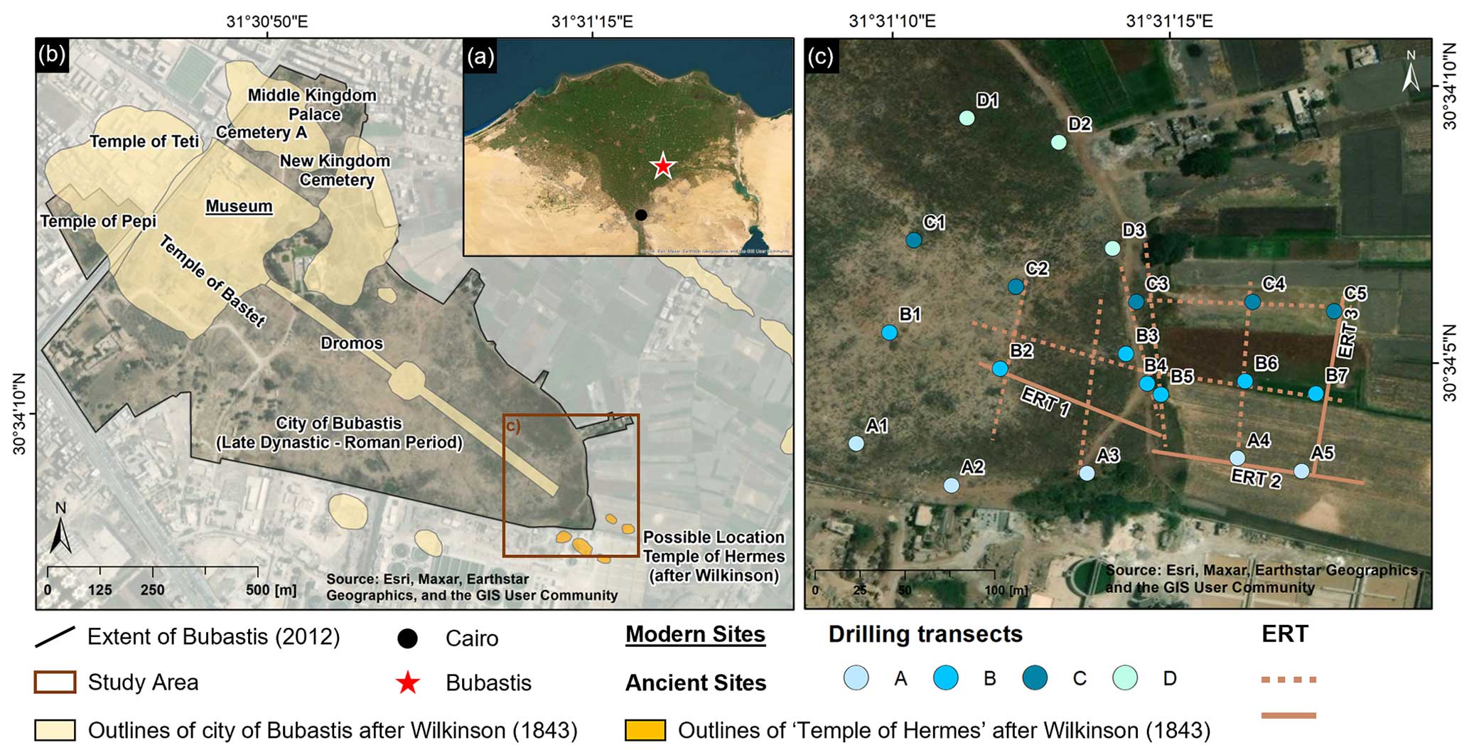
Figure 1(a) Location of Bubastis in the southeastern Nile Delta. (b) Ancient and modern features of the current extent of Bubastis. (c) Overview of drilling locations and ERT profiles (only the solid ERT lines will be used for further interpretation and discussion).
Bubastis, the ancient Egyptian city, is situated in the southeastern Nile Delta, on the southeastern edge of the modern city of Zagazig, approximately 80 km northeast of Cairo (Fig. 1a). Bubastis was an administrative and religious centre. Due to its favourable geographical location, it maintained its importance from the time of its original foundation in the Predynastic Period (ca. 3200 BCE) until its decline during the Roman dominion (ca. 200 CE) (Meister et al., 2021a). Settlements in the Nile Delta were usually built on elevated sites to protect them from the annual floods of the Nile. Buildings of great importance, such as temples, were erected on the highest points not only to emphasise their significance, but also to minimise the potential destruction caused by extremely high floods (Butzer, 2002; Garbe et al., 2023; Meister et al., 2021b). Therefore, naturally geomorphological structures, like geziras or high riverbanks, were used for settlements. Geziras (Arabic for “islands”) are exposed remnants of the Pleistocene delta surface, consisting of fluvial sediments, mostly of medium to coarse sands, that occasionally rise above the deposits of the Holocene river systems (Garbe et al., 2023; Pennington et al., 2017; Said, 2012). The gezira of Bubastis has several elevations, which were used for specific areas of the settlement (so-called koms; Arabic for “mound”). Several parts of Bubastis have been relatively well investigated, i.e. the Western Kom with the Temple of Pepi I (Garbe et al., 2024), the cemeteries and palace on the Northern Kom (Lange et al., 2016), and the Temple of Bastet on the Central Kom (Meister et al., 2021a), but other parts of the city are almost completely unexplored (Fig. 1b). For example, almost no archaeological information is available about the “Temple of Hermes” in the east of Bubastis. According to Herodotus, who also coined the name, the temple is situated at the eastern end of the dromos, the main street of the city, connecting it to the Temple of Bastet. Wilkinson (1843) may have seen the ruins of the Temple of Hermes (orange areas in Fig. 1b; after Lange et al., 2016). Nearby, during exploratory excavation, Naville (1891) found some granite blocks with inscriptions of Osorkon I (924–889 BCE), which he attributed to the Temple of Hermes. Traces of the temple have now completely disappeared, and no surface remains indicate its location (Lange et al., 2016; Lange-Athinodorou, 2019). Therefore, to determine the location of the Temple of Hermes, we searched for elevated gezira deposits at the presumed position of the building, as it would have been built on an elevated site. To investigate the subsurface and morphology of the gezira, we carried out drillings and 2D geoelectrical surveys in the southeastern area of ancient Bubastis in the spring and autumn of 2023. The selection of drilling sites was primarily based on accessibility considerations, either within the archaeological site or further east in consultation with local farmers on their fields. Notably, the region further south, marked by Wilkinson's indications, is currently an industrial area that remains entirely inaccessible for our investigations (Fig. 1).
A total of 20 boreholes were drilled in transects using a vibracorer with open steel drill heads of 1 m length and 80, 60, and 50 mm diameter into the Pleistocene gezira deposits, reaching a maximum depth of 9 m. Due to restricted sample transport, the extracted sediments were macroscopically described and analysed on-site following the Munsell colour system and KA5 (Ad-hoc-Arbeitsgruppe Boden, 2005) without further laboratory analysis. The sediment colour, grain size, redoximorphic characteristics, and specific features (charcoal, limestone, ceramic fragments, etc.) were documented.
As in previous studies (Garbe et al., 2024; Lange-Athinodorou et al., 2019; Meister et al., 2021a), well-preserved pottery sherds from the cores were analysed and compared with reference collections from the Nile Delta based on production techniques, shape, fabric, and surface treatment. For the chronostratigraphy, 47 ceramic fragments were classified into different time periods. The drillings were extended by 11 electrical resistivity tomography (ERT) measurements to provide additional areal information about the subsurface in the study area. As not all of them show clear results, the three most informative tomograms are used for further interpretation and discussion (see Sect. S2 in the Supplement for all tomograms). The 2D ERT data were acquired with an IRIS Syscal R2 instrument using the Wenner-beta configuration. Based on the experience of the previous investigations (Garbe et al., 2024; Meister et al., 2021a), geoelectric surveys were performed with 4 m electrode spacing up to a distance of 100 m. Inversion of the 2D ERT profiles was performed with Res2DInv ×64 ver. 4.08 using the smoothing-constrained least-squares inversion method. The root mean square error ranged from 3.8 % to 4.4 % with a maximum of five iterations.
3.1 Sedimentological analyses
All boreholes were categorised into three main lithological units (units I–III) based on their potential depositional milieu as indicated by differences in grain size composition, traces of anthropogenic artefacts, moisture, and colour from the in-field sedimentological investigations (Fig. 2; see Sect. S1 for detailed core descriptions and photographs).
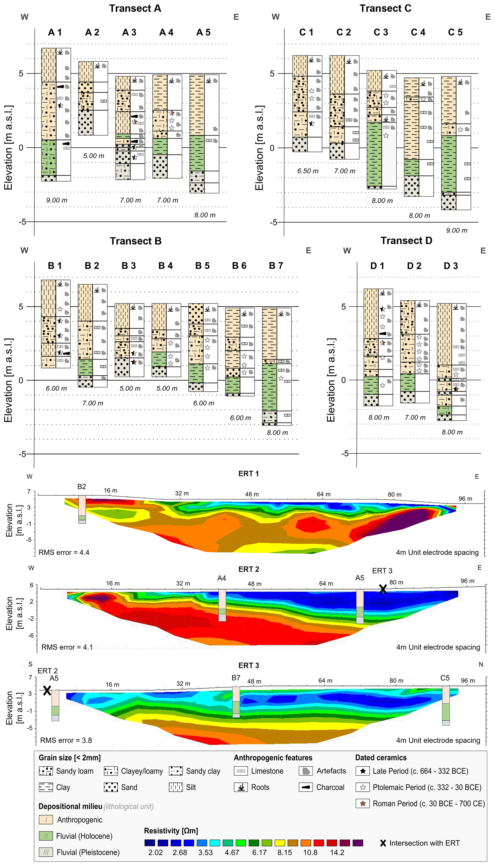
Figure 2Generalised results of drilling transect A–D and 2D electrical resistivity tomography (ERT 1–3).
The top layer in all boreholes consists of unit I with varying amounts of modern and ancient material, reaching thicknesses from 330 cm (A2, B4) to 720 cm (D1). This section is also characterised by sediment colours ranging from light to dark brownish or dark greyish and different grain size distributions. The enormous quantity of ancient and modern anthropogenic artefacts, including brick, limestone or ceramic fragments, and charcoal, proves the anthropogenic origin of this unit (Garbe et al., 2024; Lange-Athinodorou et al., 2019; Meister et al., 2021a).
In most boreholes, a layer of entirely loamy and clayey material, characterised by a dark-brownish to greyish colour and higher soil moisture, follows below unit I. These unit II deposits are small in grain size and dark in colour, indicating high organic content and suggesting a limnic or fluvial depositional setting with comparatively low flow velocities (Ginau et al., 2019). Such sediments are typical of the Nile Delta and are associated with Holocene floodplain deposits of the Bilqas Formation (Pennington et al., 2017). The thickness of the fluvial sediments of unit II varies from 30 cm (A3) to 440 cm (C3).
Unit III contains medium to coarse sandy sediments which occur in the bottom layer of all cores (except core B1), often alternating with clayey fine sand material. Deposits of unit III are greyish-blue to yellowish in colour, depending on the influence of groundwater, and are usually free of anthropogenic artefacts. The basal sediments of unit III can be assigned to the Mit Ghamr Formation or the Geziracover Formation (Garbe et al., 2024; Lange-Athinodorou et al., 2019; Meister et al., 2021a; Ullmann et al., 2019), which are characterised by fluvial sediments with varying grain sizes, based on depositional conditions within the fluvial delta system during the Pleistocene (Said, 2012). The gezira deposits occur at various depths (Fig. 3) and can be differentiated into different areas. In many boreholes, the onset of the gezira deposits is found between −0.5 and 1 m a.s.l. (A3, A4, B2, B4, B5, C1, and C2), representing a medium–high section. In contrast, in two cores (A2 at ∼ 2.5 m and B3 at ∼ 1.5 m a.s.l.), the gezira sediments rise to higher levels. However, in the remaining boreholes, the sediments of unit III occur only between −0.5 and −3 m a.s.l. and form a deeper zone. Generally, the study area was very hilly during the Pleistocene, with significant differences in altitude within short distances (e.g. 4 m difference between B3 and C3). The middle and upper depths at which the gezira deposits occur can probably be associated with one of the ancient koms of Bubastis (brownish colour in Fig. 3), which extends over the central part of the study area and on which the Temple of Hermes was presumably built. The remaining areas are more likely to be peripheral to the kom or in the lower floodplain area (blueish colour in Fig. 3). The ceramic artefacts recovered, mostly from unit I, date mainly to the Ptolemaic Period (ca. 332–30 BCE), but also to the Late Period (ca. 664–332 BCE) and the Roman Period (ca. 30 BCE–700 CE), corresponding to settlement activities in this area.
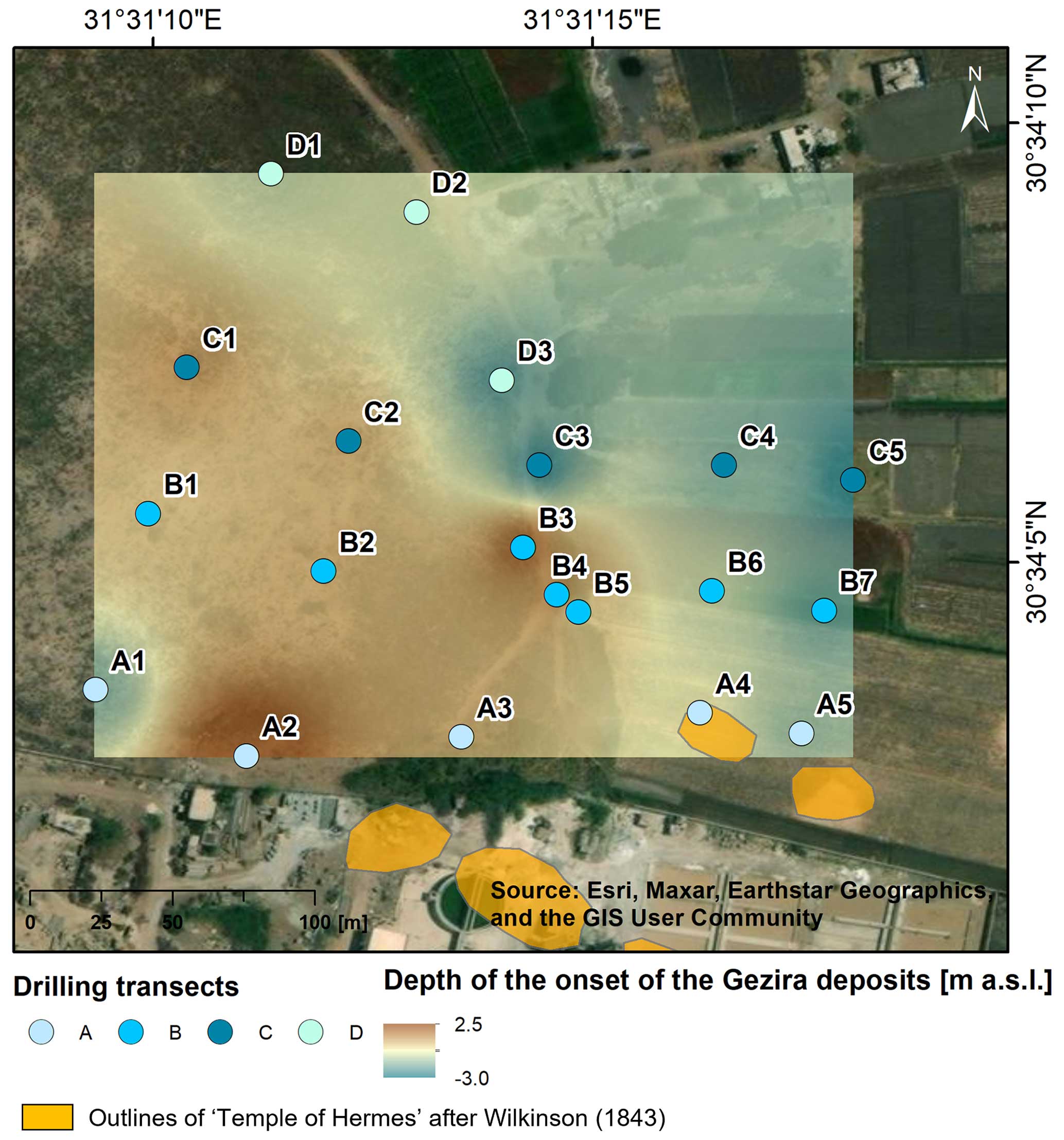
Figure 3Overview of the detected depths of the onset of the gezira deposits.
3.2 Geoelectrical investigations
The results of the 2D geoelectrical surveys are visualised in Fig. 2, together with the simplified stratigraphies of the intersecting boreholes. The measured resistivities exhibit low values, with a relatively small range spanning < 1 to approximately 20 Ω m. While the tomograms may not precisely delineate the stratigraphic units to centimetre precision as observed in the boreholes, they show the potential transition to the gezira deposits and provide complementary support for the interpretations derived from the sedimentological studies. Tomogram ERT 1 shows both high and low resistance values in the upper metres belonging to unit I and unit II, before the values rise at about 1 m a.s.l. and can be attributed to unit III. The ERT 2 and 3 tomograms show areas of very low resistivity in the uppermost metres, which correlate with the loamy–clayey material of units I and II in this area. In ERT 2, the higher resistivity values of unit III occur in the west at a depth of 2 to 3 m before decreasing towards the east and only occurring at a depth of 7 to 8 m. In contrast, the higher values in ERT 3 tend to remain constant at a depth of 5 to 6 m. Although ERT measurements are not factored into the calculation of the gezira elevation model (Fig. 3), they indicate a pattern of centrally elevated gezira deposits with a pronounced eastward dip, mirroring findings from sedimentological analyses.
The aim of this study was to identify elevated gezira deposits in the eastern part of ancient Bubastis in order to determine the location of the Temple of Hermes. The results of the survey show a central area of elevated gezira deposits between −0.5 and 1 m a.s.l. (brownish colour in Fig. 3), which decreases rapidly towards the east. This elevated area is 50 m from the location of the Temple of Hermes as described by Wilkinson (1843) and Naville (1891), thus providing a suitable area for the building. Overall, our results add important clues for definitively locating the Temple of Hermes at Bubastis. However, future archaeological excavations must verify our hypothesis.
Additional data information relating to this paper is available from the corresponding authors upon reasonable request.
The supplement related to this article is available online at: https://doi.org/10.5194/egqsj-73-95-2024-supplement.
The methodology was developed by PG, AAER and JM. The formal analysis was conducted by PG, AAER, AES and JM. All authors analysed the results jointly. Funding was acquired by JM. The manuscript was prepared by PG with contributions from all authors.
At least one of the (co-)authors is a member of the editorial board of E&G Quaternary Science Journal. The peer-review process was guided by an independent editor, and the authors also have no other competing interests to declare.
Publisher’s note: Copernicus Publications remains neutral with regard to jurisdictional claims made in the text, published maps, institutional affiliations, or any other geographical representation in this paper. While Copernicus Publications makes every effort to include appropriate place names, the final responsibility lies with the authors.
This article is part of the special issue “Quaternary research in times of change – inspired by INQUA Roma 2023”. It is a result of the INQUA conference, Rome, Italy, 14–20 July 2023.
This research has been supported by the Deutsche Forschungsgemeinschaft (DFG, German Research Foundation; grant no. 507687060).
This paper was edited by Ingmar Unkel and reviewed by one anonymous referee.
Ad-hoc-Arbeitsgruppe Boden: Bodenkundliche Kartieranleitung KA5 [Manual of soil mapping], 5th edn., edited by: Eckelmann, W., Bundesanstalt für Geowissenschaften und Rohstoffe, ISBN 978-3-510-95920-4, 2005.
Butzer, K. W.: Geoarchaeological implications of recent research in the Nile Delta, in: Egypt and the Levant: Interrelations from the 4th through the early 3rd millenium BCE, edited by: van den Brink, E. C. M. and Lewy, T. E., Leicester University Press, ISBN 0718502620, 83–97, 2002.
Garbe, P., Lange-Athinodorou, E., and Meister, J.: Mensch-Umwelt-Beziehungen im altägyptischen Nildelta, Geographische Rundschau, 75, 10–16, 2023.
Garbe, P., El-Raouf, A. A., Es-Senussi, A., Lange-Athinodorou, E., and Meister, J.: Holocene landscape reconstruction in the surroundings of the Temple of Pepi I at ancient Bubastis, southeastern Nile Delta (Egypt), Geoarchaeology, 39, 17–34, https://doi.org/10.1002/gea.21981, 2024.
Ginau, A., Schiestl, R., and Wunderlich, J.: Integrative geoarchaeological research on settlement patterns in the dynamic landscape of the northwestern Nile delta, Quatern. Int., 511, 51–67, https://doi.org/10.1016/j.quaint.2018.04.047, 2019.
Lange, E., Ullmann, T., and Baumhauer, R.: Remote sensing in the Nile Delta: Spatio-Temporal Analysis of Bubastis/Tell Basta, Ägypten und Levante, 26, 377–392, https://doi.org/10.1553/AEundL26s377, 2016.
Lange-Athinodorou, E.: Der “Tempel des Hermes” und die Pfeile der Bastet. Zur Rekonstruktion der Kulturlandschaft von Bubastis, in: En detail – Philologie und Archäologie im Diskurs, Festschrift Hans-Werner Fischer-Elfert, edited by: Brose, M., Dils, P., Naether, F., Popko, L., and Raue, D., De Gruyter, 549–585, https://doi.org/10.1515/9783110629705-027, 2019.
Lange-Athinodorou, E., El-Raouf, A. A., Ullmann, T., Trappe, J., Meister, J., and Baumhauer, R.: The sacred canals of the Temple of Bastet at Bubastis (Egypt): New findings from geomorphological investigations and Electrical Resistivity Tomography (ERT), J. Archaeol. Sci.-Reports, 26, 101910, https://doi.org/10.1016/j.jasrep.2019.101910, 2019.
Meister, J., Garbe, P., Trappe, J., Ullmann, T., Es-Senussi, A., Baumhauer, R., Lange-Athinodorou, E., and El-Raouf, A. A.: The Sacred Waterscape of the Temple of Bastet at Ancient Bubastis, Nile Delta (Egypt), Geosciences, 11, 385, https://doi.org/10.3390/geosciences11090385, 2021a.
Meister, J., Lange-Athinodorou, E., and Ullmann, T.: Preface: Special issue “Geoarchaeology of the Nile Delta”, E&G Quaternary Sci. J., 70, 187–190, https://doi.org/10.5194/egqsj-70-187-2021, 2021b.
Naville, E.: Bubastis (1887–1889), Bd. 8, Egypt Exploration Fund, https://doi.org/10.11588/diglit.6640, 1891.
Pennington, B. T., Sturt, F., Wilson, P., Rowland, J., and Brown, A. G.: The fluvial evolution of the Holocene Nile Delta, Quaternary Sci. Rev., 170, 212–231, https://doi.org/10.1016/j.quascirev.2017.06.017, 2017.
Said, R.: The geological evolution of the River Nile, Springer Science & Business Media, ISBN 9781461258414, 2012.
Ullmann, T., Lange-Athinodorou, E., Göbel, A., Büdel, C., and Baumhauer, R.: Preliminary results on the paleo-landscape of Tell Basta/Bubastis (eastern Nile delta): An integrated approach combining GIS-Based spatial analysis, geophysical and archaeological investigations, Quatern. Int., 511, 185–199, https://doi.org/10.1016/j.quaint.2017.12.053, 2019.
Wilkinson, R. H.: Modern Egypt and Thebes: being a description of Egypt, including the information required for travellers in that country, London, ISBN 9781107300514, https://doi.org/10.1017/CBO9781107300514, 1843.