the Creative Commons Attribution 4.0 License.
the Creative Commons Attribution 4.0 License.
 | 25 Feb 2025
Holocene vegetation dynamics and sedimentation processes in a small depression on a Pleistocene plain – a multi-proxy approach for the palaeoenvironmental reconstruction of a Neolithic settlement area near Leipzig, Saxony
Christian Tinapp
Maren Gumnior
Susann Heinrich
Christoph Herbig
Saskia Kretschmer
Birgit Schneider
Harald Stäuble
Astrid Stobbe
Tinapp, C., Gumnior, M., Heinrich, S., Herbig, C., Kretschmer, S., Schneider, B., Stäuble, H., and Stobbe, A.: Holocene vegetation dynamics and sedimentation processes in a small depression on a Pleistocene plain – a multi-proxy approach for the palaeoenvironmental reconstruction of a Neolithic settlement area near Leipzig, Saxony, E&G Quaternary Sci. J., 74, 79–99, https://doi.org/10.5194/egqsj-74-79-2025, 2025.
Since 2010, excavations by the Saxonian Archaeological Heritage Office have been conducted on a Pleistocene plain in northwest Saxony during the course of an open-cast lignite mining project. The area lies between the valleys of the Weiße Elster and the Pleiße in the Leipzig lowlands. An important multi-cultural site was discovered near the village of Kieritzsch, where archaeological remains from the early Neolithic up to the early Bronze Age were excavated. They are located in and around a former pond that was subsequently filled with organic-rich deposits. Various geo-archaeological investigations were carried out, complemented by radiocarbon dating to support and contextualize the archaeological results. In particular, archaeobotanical analyses (pollen and macro-remains) were carried out in order to reconstruct the landscape development of the depression and its surroundings. Thus, it was possible to reconstruct the Neolithic vegetation and land use history in a central German Altsiedellandschaft using a near-site pollen profile for the first time. The widespread pine forests were partially cleared for arable farming during the Linear Pottery culture period. From the Stroked Pottery culture period, there is significantly less archaeological evidence, while the palynological data account for sparse mixed-oak forests diversified by anthropogenic use. During the middle and late Neolithic, the number of settlement traces declines once more, even though the sedimentological record and the near-site pollen spectra show intensive land use. The woodlands in the vicinity of the pond continue to decrease, and Cerealia pollen is consistently present. After the Neolithic, the investigated profile shows a hiatus that comprises more than 3000 years. In the early medieval era deposition resumes, together with substantial deforestation and a general increase in human impact.
Seit 2010 führt das Landesamt für Archäologie Sachsen auf einer aus pleistozänen Sedimenten aufgebauten Hochfläche im Vorfeld eines Braunkohletagebaus Ausgrabungen durch. Das Gebiet liegt in der Leipziger Tieflandsbucht zwischen den Tälern der Weißen Elster und Pleiße. Neben dem Dorf Kieritzsch wurde eine außergewöhnliche, polykulturelle Siedlungsstelle entdeckt, die archäologischen Funde und Befunde reichen vom Frühneolithikum bis in die Frühbronzezeit und befinden sich in und um einen früheren Teich herum, der mit stark humosen Sedimenten verfüllt ist. Geoarchäologische Untersuchungen und Radiokohlenstoffdatierungen ergänzen die archäologischen Ergebnisse. Zudem wurden archäobotanische Untersuchungen (Pollen und Großreste) durchgeführt, um die Landschaftsentwicklung der kleinen Senke und ihrer unmittelbaren Umgebung zu verstehen. Es ist erstmals anhand eines „near-site-Pollenprofils“ gelungen, die Vegetation und Landnutzungsgeschichte einer Altsiedellandschaft in Mitteldeutschland für das Neolithikum zu rekonstruieren. Bereits in der Zeit der Linienbandkeramik wurden die weit verbreiteten Kiefernwälder zur Gewinnung von Ackerflächen gebietsweise gerodet. Aus der Stichbandkeramik gibt es deutlich weniger archäologische Belege, während die palynologischen Daten lichte, durch anthropogene Nutzung diversifizierte Eichenmischwälder belegen. Während des Mittel- und Spätneolithikums nimmt die Zahl von Siedlungsspuren erneut ab, trotzdem zeigen Sedimente und Pollenspektren weiterhin intensive Landnutzung. Der Waldanteil im Umfeld des Teiches sank weiter, und Getreidepollen sind durchgängig nachgewiesen. Nach dem Neolithikum weist das untersuchte Profil einen mehr als 3000 Jahre umfassenden Hiatus auf. Im Frühmittelalter setzt die Ablagerung erneut ein. Es zeigt sich eine stark entwaldete Landschaft und eine generelle Zunahme des anthropogenen Einflusses auf die Vegetation.
- Article
(10847 KB) - Full-text XML
-
Supplement
(13209 KB) - BibTeX
- EndNote


Archaeological excavations during the course of major construction and mining projects in the last decades have provided evidence of extensive anthropogenic activities in the Leipzig region for 7500 years (Stäuble et al., 2011; Stäuble, 2016). While knowledge of past land use is gradually increasing, at least for some specific periods, our knowledge about vegetation cover and the Holocene landscape development of this region is rather rudimentary. The major problem in the reconstruction of the regional palaeovegetation is the general lack of archives and of contemporary studies. Basic palynological investigations date back to the 1950s or 1960s (e.g. Jacob, 1957; Müller, 1953; Mania, 1967), while supplementary studies were mostly conducted in the 1990s (Litt, 1990, 1992, 1994; Stebich, 1995) or during the course of recent geo-archaeological analyses in the Leipzig area (Tinapp, 2002; Tinapp et al., 2016a, b). The majority of publications do not focus on the Middle and Late Holocene, and until the 1990s, contain no or only uncalibrated radiocarbon dates. In addition, most of the central German study sites lie far away from the Leipzig region (Müller, 1953; Wennrich et al., 2005), or they are derived from areas with a different settlement development during prehistory (Jacob, 1957). On the other hand, we have many prehistoric wells (Tegel et al., 2012; Tinapp et al., 2013; Kretschmer et al., 2016; Stäuble and Veit, 2016; Friederich, 2017; Schell et al., 2022) from which pollen samples could be partly analysed but which, however, are not representative of the regional vegetation history. All approaches dealing with organic-rich material from the few slightly incised valleys have not yielded pollen from the Atlantic period. The level of knowledge about the landscape evolution is therefore deficient. Beyond the river valleys of the Weiße Elster and the Pleiße (Hiller et al., 1991; Tinapp, 2002; Tinapp et al., 2019), we have only a few observations about the development of soil and sediments of the rather flat plains around Leipzig, with unconsolidated glacial sediments from the Early and Middle Pleistocene (Tinapp, 2008).
Since 2011, 21 archaeological sites have been excavated in the open-cast lignite mining field Peres within a total area of about 185 ha (Kretschmer et al., 2014, 2016; von Suchodoletz et al., 2019). These excavations allow for insights into the settlement development. The discovery and excavation of a former pond on a Pleistocene plain used for agriculture and the suitability of its deposits for palynological studies enable us to shed light on the landscape evolution and vegetation development in an area with a settlement history of more than 7000 years. For the first time, we are able to present data on the vegetation cover and associated land use in the immediate settlement context around Neolithic sites in northwest Saxony. The near-site profile contains not only secondary but also primary anthropogenic indicators in most pollen assemblage zones, reflecting different periods with more- or less-intensive land use. Valuable information can also be derived from the Holocene sediments and the reconstructed underlying geo-morphodynamics, in contrast to former research that had to focus on the nature of infillings of archaeological features and the comparison of postsedimentary pedogenetic processes with those within undisturbed surrounding soil (von Suchodoletz et al., 2019; Meinecke et al., 2020).
The area south of Leipzig belongs to the North German Plain (Fig. 1). The mostly flat landscape is covered with Pleistocene sediments. Around the open-cast lignite mining field Peres, a dark loamy layer of approximately 7 m in thickness (Elster-1 till) is covered by Elster-2 deposits consisting of till, sand, gravel, and clay, with a variable thickness between 1 and 5 m. At the topmost level, there is a cover of 0.5 m thick Weichselian loess, which, towards the south, grades into typical loess and increases in thickness to more than 7 m in the Altenburg-Zeitz loess hills (Eissmann, 2002).
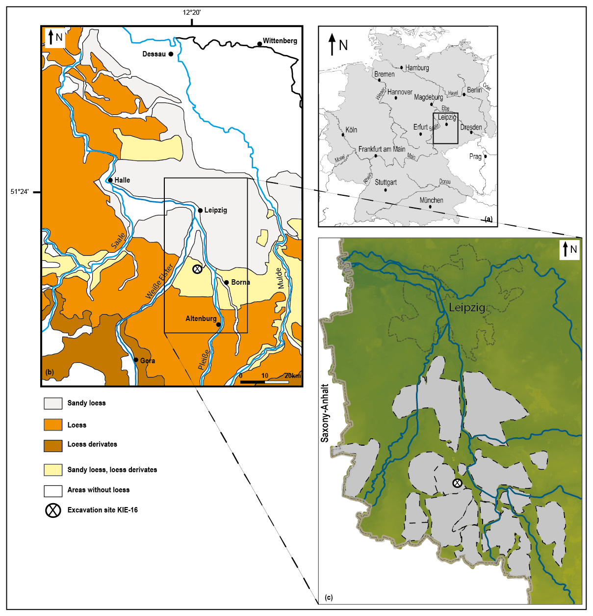
Figure 1(a) Location of the study site in Germany, (b) with the distribution of loess and loess-like deposits in central Germany without lignite mines, according to Eissmann (2002), and (c) with the mining areas south of Leipzig (in grey) and the position of the Kieritzsch site KIE-16 (map – Geodaten© Staatsbetrieb Geoinformation und Vermessung Sachsen 2024).
Palynological studies from both highland and lowland sites confirm the predominance of pine (Pinus) in the Early Holocene. It is typical of not only this region but also other subcontinental loess landscapes such as the Wetterau or the Upper Rhine Graben (Bos et al., 2008; Schweizer, 2001; Stobbe 1996). Pine occurs in combination with birch (Betula) during the Preboreal and with hazel (Corylus) in the Boreal. In the Atlantic period, it is associated with various mixed-oak forest components, depending on the site specifics (Heinrich and Lange, 1969; Kalis and Meurers-Balke, 1988; Litt, 2021; Müller, 1953; Schneider, 2018). Beside oak (Quercus), this involves elm (Ulmus), ash (Fraxinus), lime (Tilia), and maple (Acer) or spruce (Picea) at higher altitudes (Stebich, 1995). Under the present climatic conditions, such mixed-oak forests are considered the climax vegetation, often with lime (Tilia) and/or hornbeam (Carpinus). Beech (Fagus), which has been present from the late Boreal onwards and experienced a (partly strong) increase during the Subboreal (Dinies, 2021; Mania, 1967; Schneider, 2012), has never become dominant under the subcontinental climate (with an annual mean temperature of 11.3 °C and annual precipitation of 650 mm in 2023), but transitions to beech forests occur in the lower mountain ranges (Schmidt et al., 2002). Since the Bronze Age, conifer forests (especially Picea) have become more common; human impact on forest composition has led to increases in Fagus and Carpinus and partly also Fraxinus and Corylus, but in general, sparse mixed-oak forests have prevailed, and tree pollen percentages have continued to decline. Especially since the medieval era, a cultural landscape has emerged, dominated by non-arboreal pollen (NAP) values and with new anthropogenic markers such as Secale cereale and Centaurea cyanus (e.g. Schneider, 2012, 2013).
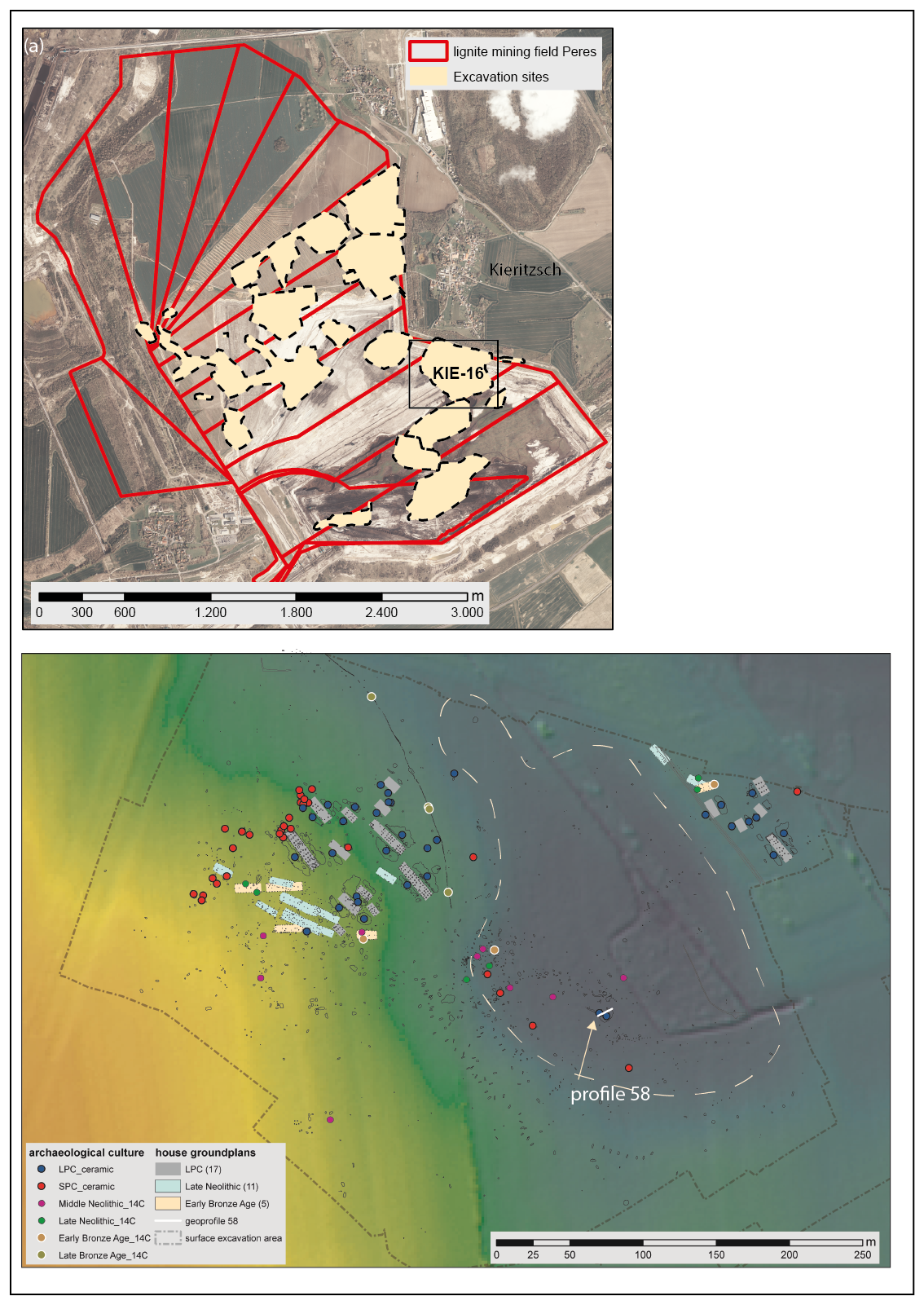
Figure 2(a) Lignite mine Peres, with extraction slices, and the Kieritzsch site KIE-16 (map – Geodaten© Staatsbetrieb Geoinformation und Vermessung Sachsen 2024). (b) Excavation area with features, house ground plans, and profile 58 in the centre of the former pond (dashed white line). Age dating was carried out using ceramics, typical house ground plans, and 14C (LPC – Linear Pottery culture; SPC – Stroked Pottery culture).
Near the flat watershed between the valleys of the Weiße Elster about 7 km to the west and of the Pleiße some 4 km to the east (Fig. 1), a site with two settlement areas of the early Neolithic Linear Pottery culture (LPC) was discovered near the village of Kieritzsch (Kieritzsch site “KIE-16”; Kretschmer and Viol, 2020). A total of 17 remains of typical LPC houses, which were built 200 m apart on opposite sides of a former pond (Fig. 2), were found. The majority of the settlement features – most of them belonging to a dozen houses on the western side and to five houses on the northeastern side – were found on a level between 144 and 146.5 m a.s.l (metres above sea level). Almost the same area was settled again in the late Neolithic and early Bronze Age (Table 1). From this period, 13 house ground plans were discovered on the western side and three on the northeastern side. A number of solitary deep pits have also been found under the organic-rich deposits at the bottom of the pond at a former elevation of around 141.7 m a.s.l. The chronology of the site is based on more than 1800 archaeological features from the immediate surroundings of the pond and another 679 within the depression. Only 195 pits were datable by archaeological finds or radiocarbon dating of short-lived charred organic material. The majority of them belong to the early Neolithic (approx. 5400–4500 cal. BCE), with only 15 structures belonging to the middle Neolithic (approx. 4500–3200 cal. BCE) and 19 to the late Neolithic (approx. 3200–2200 cal. BCE).
Table 1Periods and archaeological cultures of northwest Saxony between the early Neolithic and the early Bronze Age.
During excavations, 26 profiles were documented geo-archaeologically. They are distributed over the whole area of the former pond to find the varying thicknesses of the organic-rich sediments and the weathered loess and till of the prehistoric settlement sites. One of them, profile 58, is located at the deepest point within the former pond and has the thickest organic-rich deposits (Fig. 2). After the description of the sediments, samples were taken for multi-proxy analyses (Figs. 3, 4).
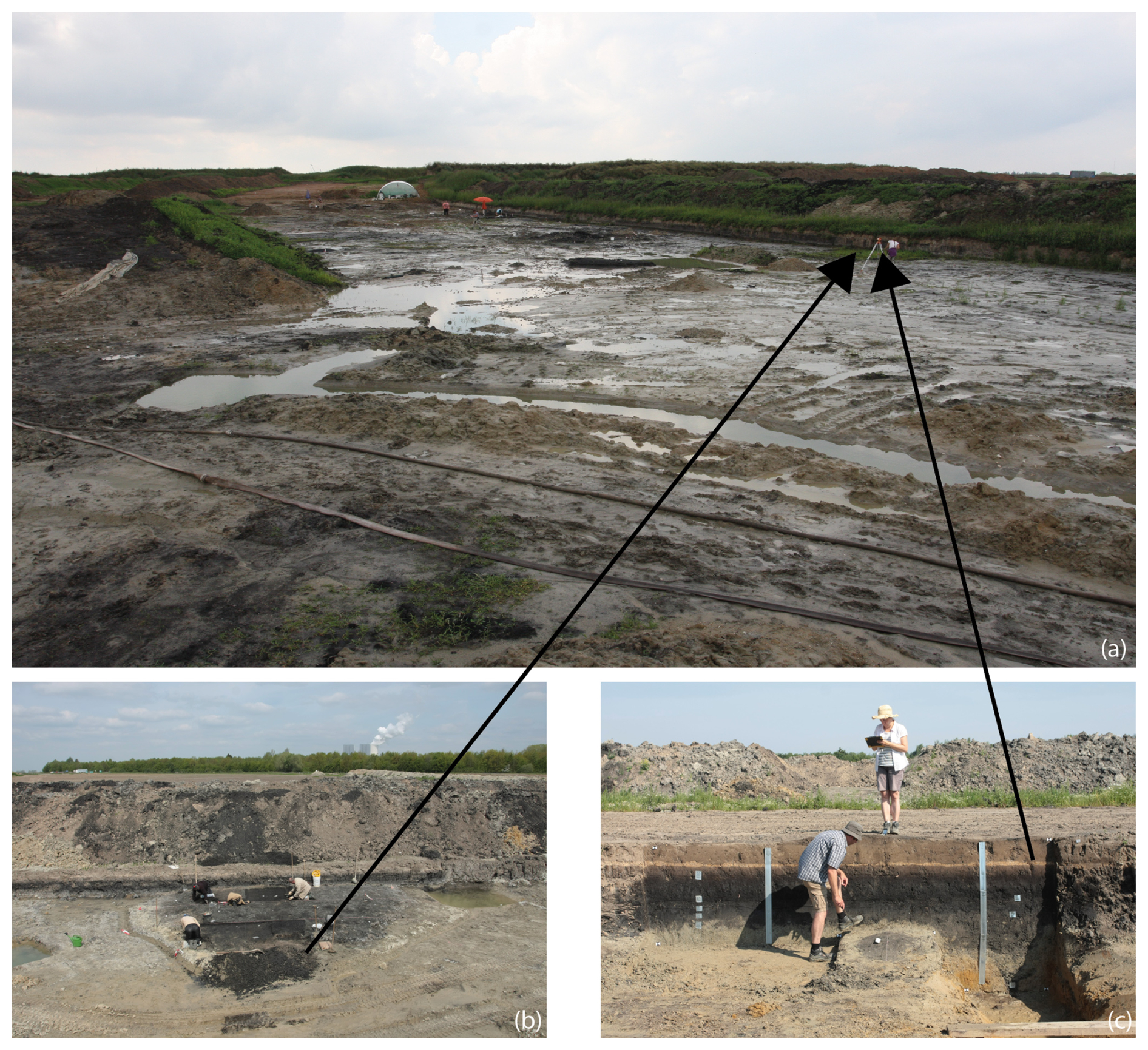
Figure 3(a) Excavation site in summer 2017. (b) Excavation of early Neolithic features at the base of the organic-rich sediments in front of profile 58 (prepared later). (c) Sampling of profile 58.
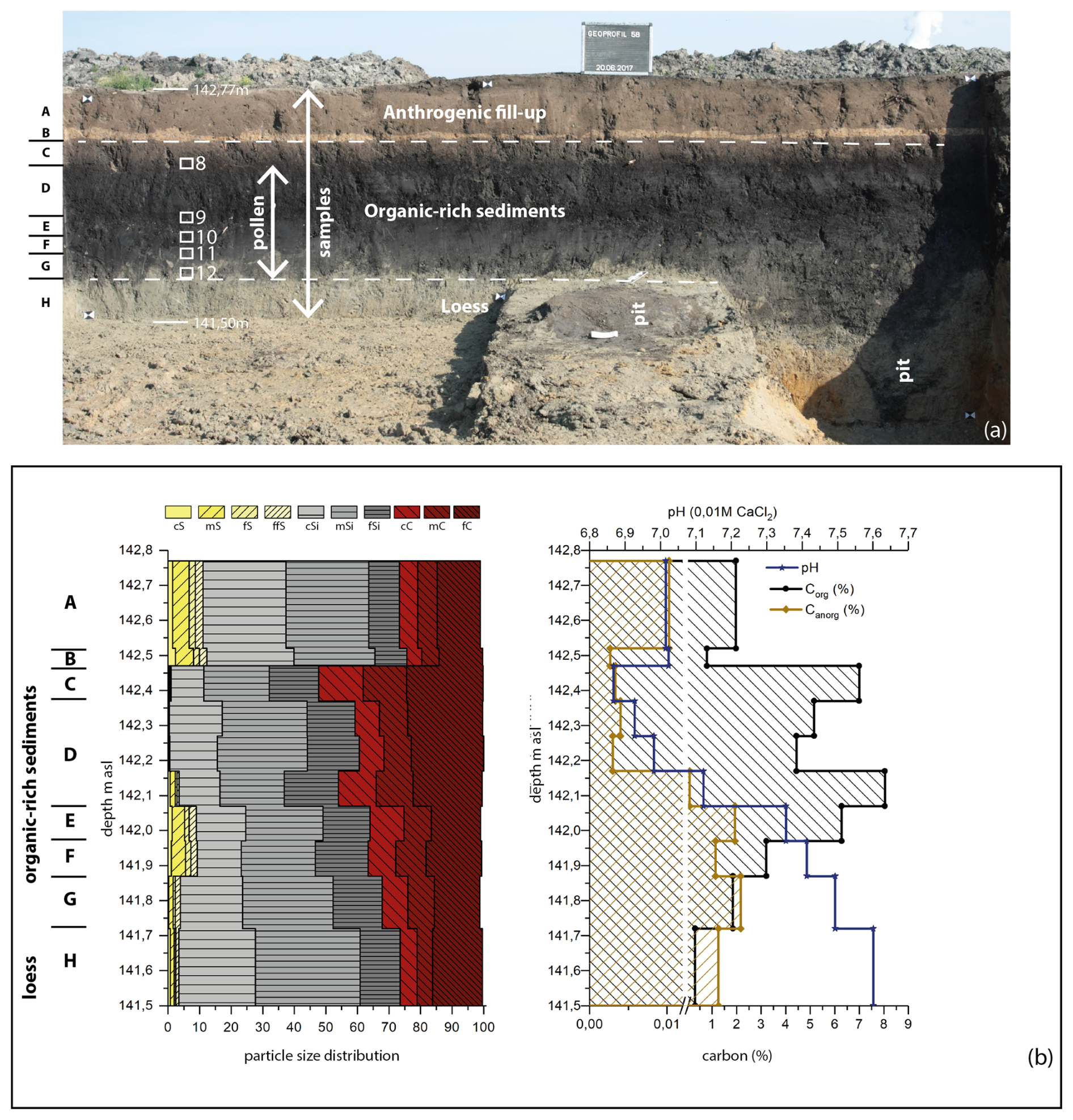
Figure 4(a) Stratigraphic units A–H with positions of the thin section samples 8–12 and the pollen and bulk samples (b). Analytical values of profile 58, with particle size distribution and pH values, as well as organic carbon, sulfur, and nitrogen contents.
3.1 Sedimentological analyses
Bulk samples were air-dried and sieved to separate coarse fragments (> 2 mm) from the fine fraction (< 2 mm). A portion of the fine fraction was ground in a planetary ball mill (PM 200) for 10 min to achieve the required grain size of < 30 µm needed for X-ray fluorescence (XRF) and elemental analysis (CNS).
Grain size analyses were conducted on the organic-free (treated with 35 % H2O2) fine fraction using a combination of dry sieving and sedimentation. The sand fraction was analysed by sieve analysis and the clay silt fraction by X-ray granulometry (XRG; Micromeritics Sedigraph III 5120). pH values were measured in a 0.01 M CaCl2 suspension following DIN ISO 10 390, with a ratio of 1 : 2.5 (soil water).
Total organic carbon (TOC) was determined by measuring total carbon (TC) with a Vario EL cube elemental analyser (Elementar) and subtracting inorganic carbon (taken from carbonate measurements) from Ct. The total contents of carbon, nitrogen, and sulfur were measured with a Vario EL cube element analyser. The determination of the carbonate content was performed via the volumetric method, referring to the Scheibler calcimeter by Eijkelkamp.
The finely homogenized samples (< 30 µm) were analysed for their element concentrations using non-destructive X-ray fluorescence (XRF) spectrometry. For this purpose, bulk samples were mixed with a wax binder (CEREOX Licowax) and pressed into 32 mm pellets. The measurements were performed via the energy-dispersive polarization XRF (ED-PXRF) SPECTRO XEPOS (SPECTRO Analytical Instruments Ltd.) analyser in a helium gas atmosphere. The contents of all elements from sodium to uranium were determined simultaneously and adjusted to the sample weight.
Pedogenesis depends on not only the properties of the parent material, the climatic conditions, and human activity but also time, to a significant degree. Weathering indices are multicomponent ratios of lithogeochemical compositional elements and are commonly used to estimate weathering intensity since they depict structural and mineralogical changes in the sediments during weathering. Over the past decades, very different indices and element ratios have been developed for different sediments in various climates (Pandarinath, 2022). Generally, the applied ratios, usually expressed as oxidic proportions in mol determined by means of XRF, are included in the calculation. The ratios used should only have been altered by pedogenetic processes.
During weathering, soluble cations with a low ion potential < 3 (e.g. K+, Na+, Ca2+, Mg2+) are washed out relatively easily, whereas e.g. Al3+, with a high ion potential of 5.9, is bound in clay minerals and forms relatively insoluble hydroxides between pH 4 and 10. Thus, the Al2O3 content changes very little during weathering and can hence be assumed to be constant (Kausch, 2009; Bowen, 1979). Consequently, we selected the weathering index (VWI) of Birkeland (1999), with low ratios indicating intensive weathering:
The element distribution depends significantly on the grain size (Matys Grygar et al., 2020). For that reason, the more weathering-resistant elements Ti or Zr should be used instead of Al as an immobile element for calculating the mass balance. Yang et al. (2016a, b, 2006) defined a loess chemical weathering proxy (LCWP) to reveal the weathering trends in aeolian Pleistocene deposits.
This ratio of the decarbonated residue is only slightly influenced by grain size and is therefore a reliable proxy for estimating the chemical weathering of loess deposits. Different grain size fractions have only a minor influence on the amount of TiO2. Besides, higher MgO contents in the fine-grain fractions are compensated by lower Na2O and CaO values. Only a slight variation in the sum of Mg, Na, and Ca is recorded when the grain size changes. Thus, the LCWP proxy is a robust indicator of the intensity of chemical weathering, as it also eliminates or at least reduces the influence of transport-related differentiation of minerals (Yang et al., 2006).
Sediments contain manganese in the form of carbonate phases and oxyhydroxide phases. Due to their responsiveness, the trace metals Fe and Mn are good indicators of aquatic environments. Both concentrations depend strongly on the redox system (Hem, 1981; Margalef et al., 1976; López Laseras et al., 2006). Low-oxygen conditions are indicated by a higher Fe Mn ratio, which can be explained by the faster reduction in Mn compared to Fe under anoxic conditions (Naeher et al., 2013). Thus, Fe compounds precipitate first under reducing conditions at lower redox potentials compared to Mn compounds (Lampe et al., 2016). In addition, the different behaviour of manganese in oxidizing and reducing environments causes different concentrations. During times with anoxic conditions, a significant proportion of the deposited Mn(III,IV) oxides is reduced and released into the water column as Mn2+. In contrast, the reduction in Fe(III) oxides and the release of Fe2+ are not noticeably enhanced under anoxic conditions. Besides, Fe2+ oxidizes faster than Mn2+ when the oxygen content increases. It is therefore possible to understand the occurrence of suboxic and anoxic conditions using the Fe Mn ratio. Thus, this ratio is a good proxy for lacustrine sediments (Loizeau et al., 2001; Wersin et al., 1991). The V Cr ratio is another index for detecting predominantly reduced conditions. It is assumed that V is enriched in organic compounds in reducing environments (Bonatti et al., 1971), while the Cr content remains nearly unchanged. For that reason, the enrichment of V compared to Cr is considered evidence for intensive reduction (Dypvik, 1979). At a ratio V Cr> 2, a sapropelic facies with anoxic depositional conditions is assumed, with H2S present in the water above the sediment. Values below 2 indicate increasing oxidizing conditions, while values around 1 indicate that the O2–H2S interface is in the sediment (Jones and Manning, 1994).
Using Mg Ca and Sr Ca ratios, the naturally occurring CaCO3 modifications aragonite and calcite can be classified. Mg2+ ions in water inhibit calcite formation, and high Mg Ca ratios indicate a favouring of aragonite formation, while low Mg Ca ratios indicate calcite formation (Chen et al., 2016; Yang et al., 2014; Morse et al., 1997). Aragonite usually develops as a secondary mineral through chemical precipitation from calcareous water at low temperatures near the surface. Some authors were able to demonstrate that aragonite is abundant in sediments with higher Sr Ca ratios (Bayon et al., 2007; Nöthen and Kasten, 2011). During weathering processes, both Ca and Sr are removed to a significant extent. Since the Ca2+ ion is slightly smaller than Sr2+ at 100 pm, calcium is more soluble than strontium. Strontium is therefore bound more tightly to clay minerals and accumulates through this fixation (Singer and Navrot, 1973). Biogenic shell material, such as calcite shell fragments from foraminifera, exhibits low Sr Ca × 104 ratios of about 30 and small Mg Ca ratios, while aragonite showed ratios of Sr Ca × 104 > 100 (Morse and MacKenzie, 1990; Wegwerth et al., 2014). These proxies help to distinguish between lithogenic and biogenic conditions.
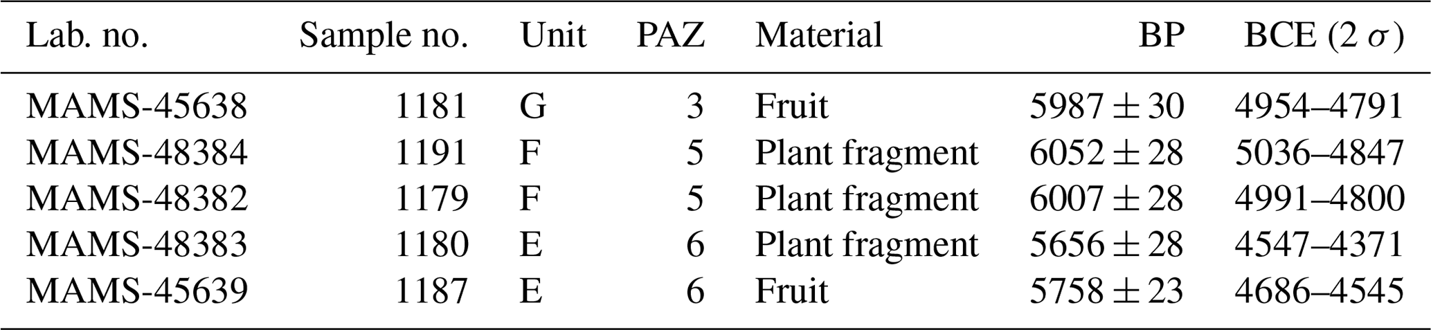
3.2 Radiocarbon dating
Five radiocarbon samples were analysed in the Curt-Engelhorn-Zentrum Archäometrie in Mannheim (CEZ) using accelerator mass spectrometry (AMS) radiocarbon dating and were calibrated using IntCal20 and SwissCal 1.0.
3.3 Micromorphology
Five thin sections for micromorphological analysis were prepared from oriented and undisturbed soil samples of the sediment units C to H. After being impregnated with resin, the thin sections were analysed using a petrographic microscope under plane polarized light (ppl), crossed polarized light (xpl), and oblique incident light (oil). The microscopic description mainly followed the terminology by Bullock et al. (1985) and Stoops (2003).
3.4 Pollen analyses
Pollen samples (n = 48) were extracted between 30 and 98 cm in depth, corresponding to absolute altitudes of 141.70 to 142.40 m a.s.l. (sedimentological units G to D). The analyses were carried out according to the standard method of Fægri and Iversen (1989): Lycopodium tablets were added in order to determine pollen concentrations (Stockmarr, 1971). The material was embedded in silicone oil and examined under the light microscope at magnifications of 470 and 756. The reference collection of the Archaeobotanical Laboratory, Institute of Archaeological Sciences, Goethe University Frankfurt and the relevant literature (e.g. Moore et al., 1991; Punt, 1976; Punt and Clarke, 1980–1984; Punt and Blackmore, 1991; Punt et al., 1988, 1995, 2003, 2008) were used for taxa identification and subsequent nomenclature (in cases where it was evident that only certain species could have been present in the particular region, the type suffix was omitted). Results were processed with the Tilia software (version 1.7.16) and presented as percentage diagrams. The pollen zones were defined on the basis of visual interpretation of the depth distributions, adding up to nine pollen assemblage zones (PAZs), in two cases with subzones. Average pollen concentrations reached 6877 grains per cm3 (minimum of 5210 at 85 cm/141.85 m a.s.l. and maximum of 13 510 at 90 cm/141.80 m a.s.l.), and – due to the relatively poor quality of the material – the mean pollen sum was 336 ± 156. This can hardly be avoided since semi-terrestrial conditions do not allow for the same level of conservation as undisturbed bogs and/or lakes, which, however, have the disadvantage of usually being farther away from the archaeological sites of interest. Included in the pollen sum are trees and shrubs (without the wetland taxa Alnus, Salix, and Populus, as they are believed to represent the local vegetation), grasses, and herbs (with the exception of Cyperaceae). Originally, we intended to determine Cerealia pollen (following Beug, 2004), but since corrosion had usually affected the tectum, only Secale cereale has been listed separately.
3.5 Palaeobotanical analyses
Corresponding to the sediment units, 11 samples for plant macro-remains investigations have been taken from profile 58. Macro-remains were extracted using a combination of flotation and wet sieving (mesh widths of 2, 0.5, 0.25 mm) and determined under magnifications from × 6.3 to × 40 using the standard literature (e.g. Cappers et al., 2006) and the reference collection at the Archaeobotanical Laboratory, Institute of Archaeological Sciences, Goethe University Frankfurt. With the exception of numerous oospores of Characeae, which have been extrapolated, all plant macro-remains have been sorted out. Attribution of the taxa to ecological units followed Oberdorfer (2001).
4.1 Sedimentology and micromorphology
In the deepest part of the former pond, the bottom of the profile 58 comprises the Elster-1 till at the base and the loess cover above, both showing signs of former waterlogging. The organic-rich sediments on top have been divided into seven units by colour, differences in particle size distribution, and the organic and inorganic carbonate content (Fig. 4 and Supplement).
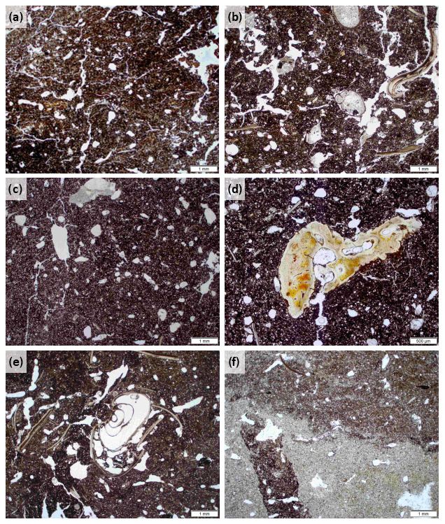
Figure 5Microphotographs of the thin sections (all in ppl, sample positions in Fig. 4). (a) Sample 8, fine-grained material from unit D, intensively bioturbated and rich in organic matter. (b) Sample 10, numerous mollusc shells from unit E, material rich in organic matter and calcium carbonate. (c) Sample 11, material from unit F, originally poor in calcium carbonate, containing bioturbated admixtures of calcareous material from the sediment units above and below. (d) Sample 9, bone fragment from unit E. (e) Sample 12, mollusc shells from unit G. (f) Sample 12, sharp boundary between sediment units G (upper part) and H (lower part), the dark material rich in calcium carbonate and organic matter as channel infilling of the light-grey material of sediment unit H.
The bottom layer (the lower part of thin section in sample 12, sedimentary unit H) is fine-grained (predominantly silty), light grey in colour (5Y6/2), and densely packed (Fig. 5e–f). It is poor in calcium carbonate but contains patches of secondary carbonate precipitates, which have entered the material with the seepage water from the overlying calcareous sediment units. The grey colour of the sediment is mainly a consequence of reducing conditions due to a high groundwater level. The boundary to the overlying humus-rich sediments is extremely sharp. However, in the upper part of the thin section of sample 12 (unit G), large shred-shaped inclusions of the material from unit H are found. These are not due to bioturbation processes and are probably mixed in by human or animal activities such as trampling.
Sediment units G, F, and E (the thin-section samples 9–12) are composed of very dark material (G – 5Y3/1; F and E – 2.5Y2.5/1) that is rich in organic matter and contains varying amounts of calcium carbonate (Fig. 5b–d). While units E and G are richer in calcium carbonate, including numerous mollusc shells and bone fragments, sediment unit F was originally poor in calcium carbonate but contains bioturbated admixtures of calcareous material from the sediment units above and below. This leads to an overall calcium carbonate content similar to that of unit G (Fig. 4). The organic carbon reaches 3 % in unit F. The sand values rise from 3 % to 10 %, while silt remains the main particle size fraction. More than 30 % clay proves temporary lacustrine conditions. In unit E, the organic carbon content reaches more than 6 %. Sand, silt, and clay percentages are similar to those in unit F.
In the upper part of the profile (sediment units D and C), the material is fine-grained (predominantly silt), dark coloured (C – 2.5Y3/2; D – 2.5Y2.5/1), free of calcium carbonate, and intensively bioturbated (Fig. 5a). Both sediment units are rich in organic matter and contain pieces of charcoal and partly decomposed plant material. The highest organic carbon values were reached in unit D, with more than 8 % at the bottom and nearly 7 % at the top. Silt and clay are fluctuating around 50 %, while the sand content is below 1 %, which is typical of lacustrine deposits. Clay peaks correlate with the highest organic carbon and nitrogen contents. The pH value drops below 7 in unit D, which correlates with declining inorganic carbon values.
It is probable that the fine sediments were covered by fill material to facilitate land cultivation in the 20th century (units A and B) since these deposits are completely different regarding particle size distribution and colour (A – 10YR4/2; B – 10YR6/6). Unit A comprises the plough horizon of the last decades.
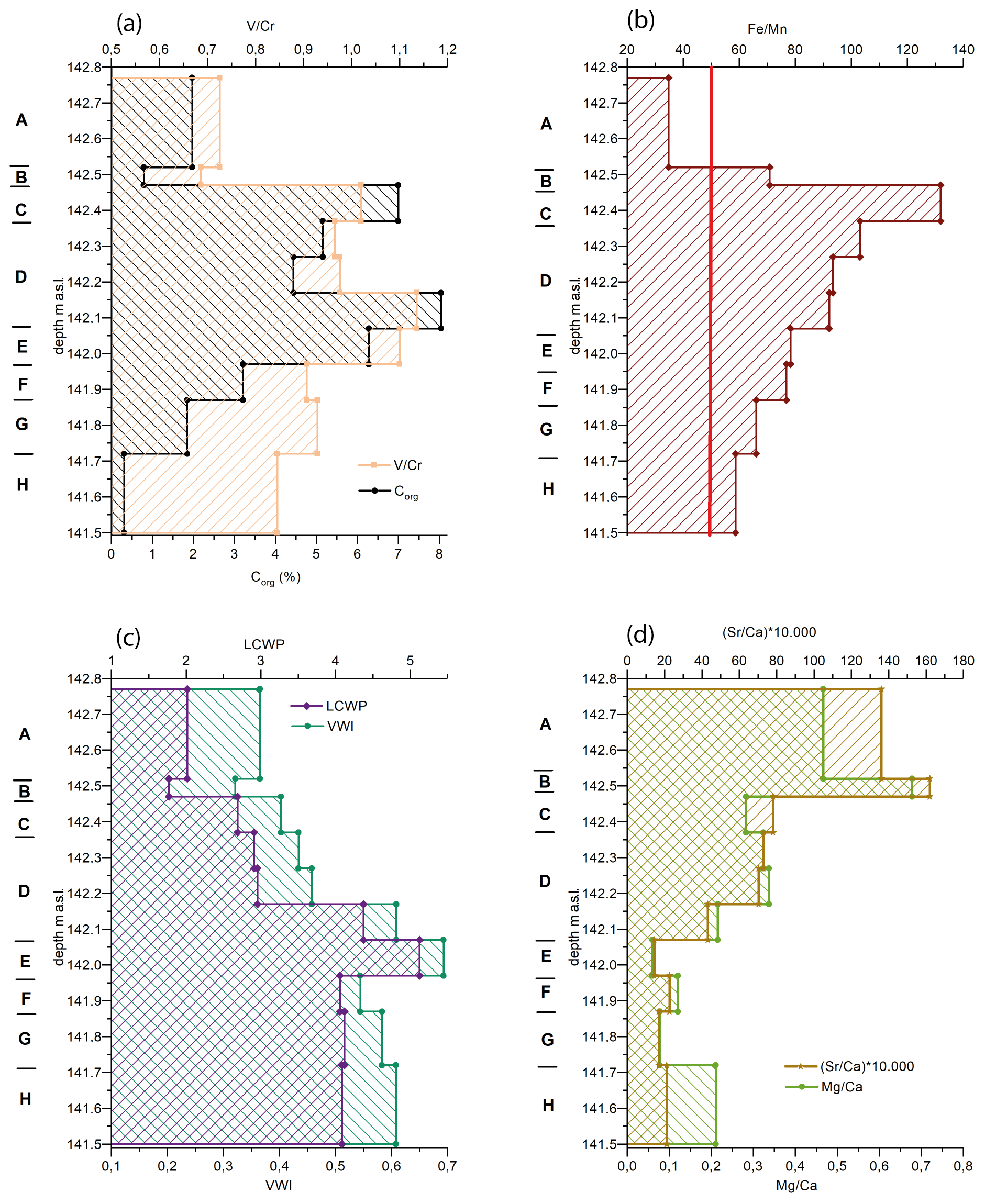
Figure 6Profile 58, with element ratios: panel (a) shows weathering indices VWI and LCWP. (b) The Fe Mn ratio. (c) V Cr vs. Corg content. (d) (Sr Ca) × 104 vs. Ca Mg.
The predominantly moist anaerobic conditions were confirmed geochemically by the V Cr and Fe Mn ratios (Fig. 6a, b). The Mn Fe in the Earth's crust is approximately 0.022, which corresponds to an Fe Mn ratio of 45. The sediment is considered to have experienced reduction reactions at a ratio of Fe Mn > 45, while Fe Mn < 45 gives evidence of increasing oxidation reactions. In the entire profile (except unit A), the sediments were strongly influenced by reduction reactions, as the ratios of the organic-rich sediments are greater than 45 (He et al., 2023). This is confirmed by the V Cr ratios (Fig. 6a). The enrichment of V in the organic matrix under reducing environmental conditions is obvious. In particular, the high Corg contents in units C, D, and E correlate clearly with high V Cr in the range between 0.9 and 1.2. These high V Cr ratios therefore demonstrate an intensive reduction, although sapropelic facies cannot yet be assumed since the ratio is still less than 2.
The weathering indices ( and ) decrease during weathering processes, as the removal of easily soluble elements caused by weathering processes is indicated in relation to weathering-stable oxides such as Al2O3 or TiO2. A clear difference in weathering is visible in unit D (Fig. 6c). Higher weathering indices are detected in the bottom part of unit D and in units E–H, which suggest minor weathering phenomena. The values of the indices of the upper part of unit D and units C–A are lower, showing more weathered material.
Below unit D, there is a clear decrease in Sr Ca × 104 < 30, which gives evidence for stronger biogenic influence (Fig. 6d). Numerous mollusc fragments in the organic-rich sediments were detected in the profile and in the surrounding deposits. Due to the strong binding of Sr to clay minerals and the associated enrichment and fixation, more weathered material causes higher Ca Sr × 104 ratios. The results correlate well with the weathering indices VWI and LCWP (Fig. 6c). The strongest weathering reactions are clearly visible in units A and B, while the lower weathering reactions in units E–G are obvious.
4.2 Pollen analyses
The pollen diagram, with an overview of the designated PAZ as described below, is also depicted in Fig. 7.
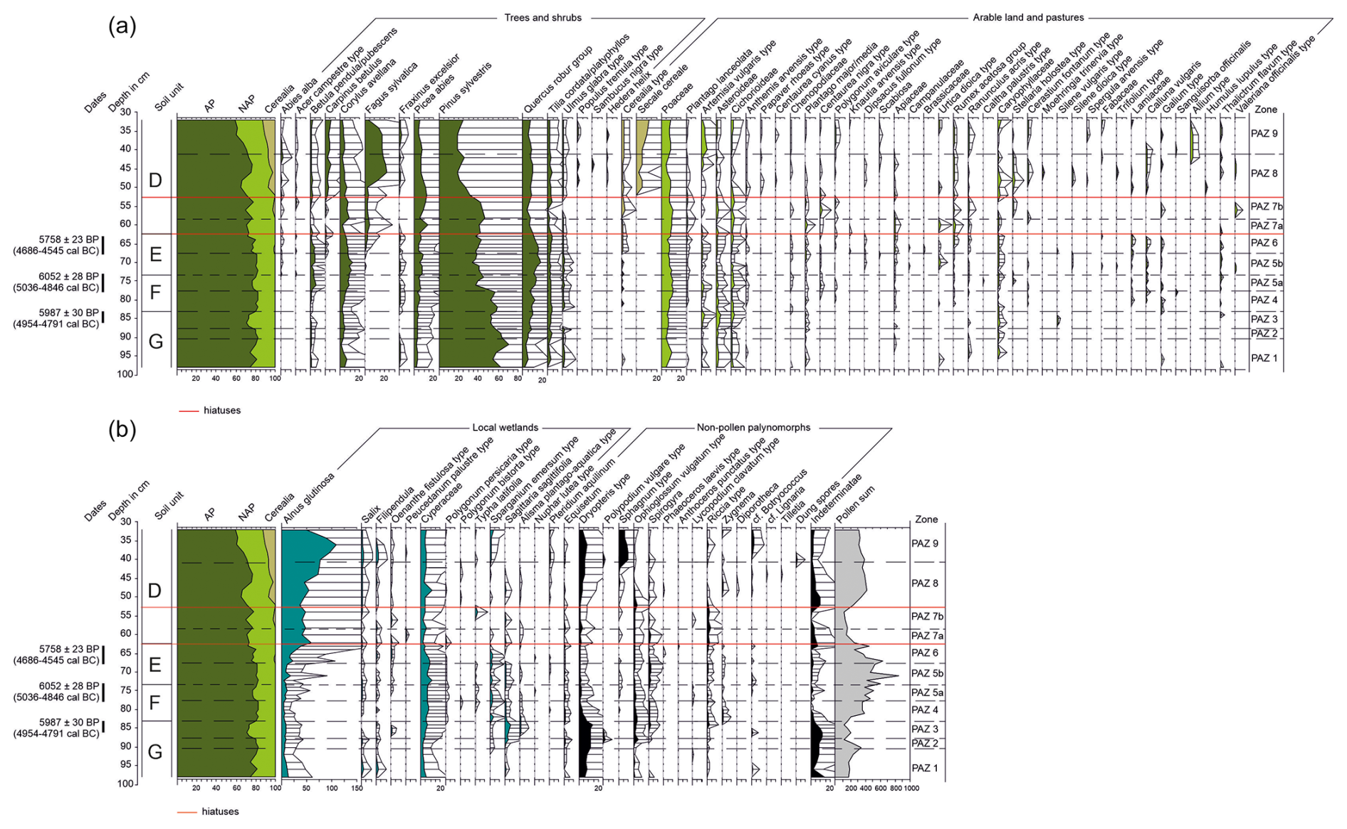
Figure 7Pollen diagram of profile 58, 141.72 m a.s.l. (98 cm)–142.38 m a.s.l. (32 cm), covering regional (a) and local spectra (b) and 14C data (Table 2).
4.2.1 PAZ 1 – approx. 141.72–141.81 m a.s.l. (unit G) – four samples
In pollen assemblage zone 1, the regional tree pollen percentage reaches between 74 % and 82 %, among which Pinus dominates, with total shares of 53 % to 71 %. Lower Pinus values are associated with an increase in grasses (up to 10 %) and herbs such as Artemisia and Asteraceae (Asteroideae/Cichorioideae). Plantago lanceolata and Cerealia pollen (Triticum type) were observed as well.
Locally, Dryopteris and Cyperaceae occur, together with Alnus and Salix. Algae such as Spirogyra andBotryococcus were identified as well.
4.2.2 PAZ 2 – approx. 141.81–141.84 m a.s.l. (unit G) – three samples
Pine values are reduced in favour of deciduous trees, especially Quercus and Tilia, but minimal amounts of Ulmus and Fraxinus pollen are present. There is no occurrence of Cerealia pollen, but Plantago lanceolata is still present. Around the pond, Sparganium emersum type and Sagittaria sagittifolia were proven.
4.2.3 PAZ 3 – approx. 141.84–141.87 m a.s.l. (unit G) – four samples
Arboreal pollen (AP) values drop to 71 % (especially Pinus to around 50 %), while Fraxinus and Ulmus are no longer accounted for. Artemisa, Asteraceae, or Plantago major/media are increasing. There is an increase in Sagittaria and Alisma and a reduction in Salix. Cyperaceae pollen and spores of Sphagnum, Ophioglossum, and Dryopteris are common as well.
4.2.4 PAZ 4 – approx. 141.87–141.93 m a.s.l. (unit F) – six samples
The total tree pollen once again reaches the maximum values of PAZ 1 (74 % to 82 %) or even exceeds them. Towards the middle, there is another slight decline in Pinus in favour of deciduous trees, with the reappearance of Ulmus and Fraxinus. However, anthropogenic indicators such as Cerealia pollen as well as Plantago lanceolata, Centaurea nigra, and Chenopodiaceae are clearly present. Locally, Dryopteris has declined, and Cyperaceae are on the rise. Ophioglossum vulgatum and Riccia glauca have slightly increased as well.
4.2.5 PAZ 5a and b – approx. 141.93–142.04 m a.s.l. (units F and E) – 10 samples
In PAZ 5a, Pinus values have dropped significantly, while Quercus, and particularly Heliophilus pioneer species like Corylus and Betula, are increasing. Alisma plantago-aquatica and Spirogyra are decreasing.
In PAZ 5b, Quercus values rise once more, the Pinus numbers are slightly reduced, and Fagus appears for the first time. Higher proportions of Urtica and Plantago major/media occur, while Cyperaceae dominate locally.
4.2.6 PAZ 6 – approx. 142.04–142.08 m a.s.l. (unit E) – five samples
The proportion of tree pollen decreases once more in PAZ 6. Fagus is continuously present after 4500 cal. BCE. As in the uppermost sample of PAZ 5b, Carpinus pollen occurs sporadically. Cerealia pollen now consistently appear, and Plantago lanceolata but also Chenopodiaceae or Rumex are more common as well. Alder increases while Cyperaceae decrease in the upper part of the pollen assemblage zone.
4.2.7 PAZ 7a and b – approx. 142.08–142.19 m a.s.l. (unit D) – five samples
In this zone, the pollen concentration is relatively low. The tree percentage is gradually reduced, although fluctuations can be seen. Compared to a noticeable Quercus, Tilia, and Corylus decline in PAZ 7a, Pinus, Fagus, and Picea show relative increases.
In PAZ 7b, Ulmus disappears almost completely. Values of Cerealia pollen, grassland taxa, and herbs are increased, as well as Alnus on a local scale.
4.2.8 PAZ 8 – 142.19–142.29 m a.s.l. (unit D) – six samples
Total tree values fluctuate, with an average around 70 %. At the same time, Pinus drops sharply to around 19 %. Fagus now reaches 18 %, and Quercus values increase as well. Carpinus and Secale cereale are rapidly gaining importance, while Papaver rhoeas and Centaurea cyanus also occur. Locally, alder dominates.
4.2.9 PAZ 9 – above 142.29 m a.s.l. (unit D) – five samples
Tree pollen is at its lowest levels (between 50 % and 60 %). Secale values continue to rise, as do Artemisia. In the local vegetation, maximum Alnus shares can be observed, together with the appearance of ferns and mosses.
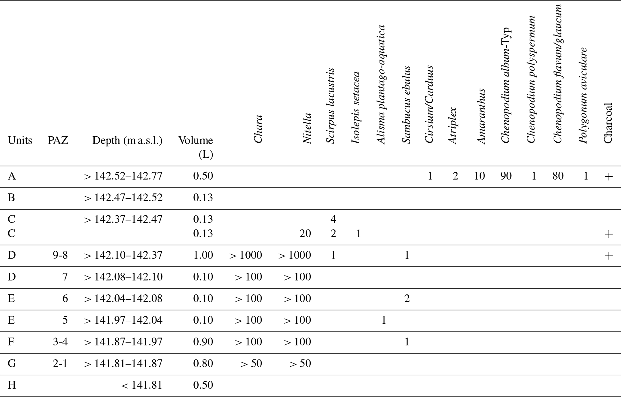
4.3 Plant macro-remains
In unit H, no plant macro-remains were found (Table 3). Units G to C contained a large number (several hundreds) of oospores from the genera Chara and Nitella, whereas unit D was very rich in propagules of these freshwater algae, with several thousand remains. Other plant macro-remains were rare in the samples. Only 13 seeds and fruits have been identified. The wetland plants found in profile 58 are lakeshore bulrush (Scirpus lacustris) in units D and C, bristle-club rush (Isolepis setacea) in unit C, and water plantain (Alisma plantago-aquatica) in unit E. Furthermore, danewort (Sambucus ebulus), a robust perennial herb occurring frequently in hedgerows, waste ground, and permanent pastures, has been found in units F, E, and D. In general, the objects show signs of poor preservation. The skinny oospores are flattened by pressure and are often fragmented. The same applies to the fruits and seeds of the other species except for the danewort, whose seeds are very robust. Unit A shows modern disturbance due to findings of recent diaspores of orache (Atriplex), amaranth (Amaranthus), various goosefoot species (Chenopodium spp.), thistles (Cirsium/Carduus), and common knotgrass (Polygonum aviculare). Finally, some tiny charcoal fragments (maximal length of 5.2 mm) have been detected in units D, C, and A.
5.1 Sedimentation processes and soil development
The unique conditions provide new insights into sedimentation processes in an Altsiedellandschaft on a Pleistocene plain used for agriculture near Leipzig. The only previously known Holocene sediments in such an environment were colluvial deposits, which were closely linked to erosion processes caused by agriculture (Tinapp, 2008). Here, near the shallow, poorly drained watershed between the valleys of the Weiße Elster and the Pleiße rivers, a pond had been developing in the Atlantic period since the early Neolithic and was subsequently filled with lacustrine and colluvial sediments.
The base of the organic-rich sediments consists of loess, which covers the Elsterian deposits throughout the entire plain. Soil forming processes like clay illuviation and waterlogging visibly affected the loess cover in the near surroundings (von Suchodoletz et al., 2019; Meinecke et al., 2020). In the depression at the Kieritzsch site, the underlying bed consists of Elster-1 till, which is a widespread aquiclude in the region (Eissmann, 2002). A thin humic topsoil developed out of loess at the former Late Pleistocene surface in the depression at the Kieritzsch site. During the Early Holocene, there was obviously no deposition, and the loess was temporarily aerated, which is probably why there is almost no pollen preservation in unit H. When the climate became moister during the Atlantic period, the groundwater table rose and the episodic sediment input mostly occurred under water-saturated anaerobic conditions where the decomposition of organic matter is inhibited, and the resulting subhydric soil shows hardly any other pedogenic features.
The appearance of the first settlers in Saxony in the early Neolithic and the development of a pond seem to be linked. During the excavation campaign, we found neither a creek nor a dam structure in the southeast, which is the general drainage direction (Fig. 2). We therefore assume that the clearing of the forests led to a rise in groundwater levels and increased surface run-off processes. The pond developed in a former poorly drained depression as soon as the first settlers arrived. Similar observations have been published for other European regions (Berglund, 1983). Probably caused by trampling by humans and/or animals during the early Neolithic, the lower part of the humic topsoil material was mixed with the underlying loess (unit G). Silty and clayey sediments were further deposited on the former topsoil (units F and E, Fig. 4), partly as a result of lacustrine sedimentation. The main coarse components are medium and fine sands. Both were present in the overlying loess and in the glacial deposits. It is likely that aeolian erosion processes led to increasing proportions of sandy material in the pond, which was surrounded by open cultivated land, as shown by the pollen analyses (Fig. 7). In unit D, we have less than 1 % sand; the main components are clay and silt. The temporary waterlogging led to incomplete decomposition, so we obtain the highest values for organic carbon in this unit. The micromorphological investigations show partially decomposed organogenic material that has been mixed by bioturbation.
On the one hand, there is evidence of a pond, but on the other, a number of deep pits were dug into the Pleistocene deposits under the pond. These archaeological features date from the early Neolithic to the early Bronze Age (Kretschmer and Viol, 2020). It was presumably only possible to dig holes there at times when the pond had little or no water. As micromorphological investigations have revealed, lacustrine deposition during wetter phases with high groundwater levels was followed by bioturbation in drier phases. Together with radiocarbon dating, pollen analysis proved that there was no continuous deposition (Fig. 7), and some major sedimentation gaps have been detected, which were not macroscopically visible in the organic-rich sediments (Fig. 4). It therefore appears that there were periods of sedimentation during the early Neolithic, interrupted by droughts that not only allowed but also necessitated the construction of pits in order to secure the water supply during such drier periods.
The weathering indices (Birkeland, 1999; Yang et al., 2006) and pollen analyses give evidence of a sediment change in unit D. The hiatus lies between the lower part containing late Neolithic pollen and the middle and upper sections belonging to the medieval period (Fig. 7) that correspond to the nearly vanishing sand contents of the organic-rich sediments in the middle and upper part of unit D (Fig. 4b). Given the geomorphological background of the Kieritzsch site, we can exclude erosion processes. One hypothesis explaining the hiatus is a disturbance by digging activities, followed by calm sedimentation. This would mean that sediments had actively been removed in the course of clean-up operations, signifying that the pond was still in use. An irregularity within the colluvial architecture was not traceable within at least 10 m from the sampled profile (Fig. 4a); former digging activities are therefore hard to imagine. Another hypothesis is a sedimentation gap over a time span of more than 3000 years at this site. By all means, such a long period without sedimentation is astonishing, but it fits well with the archaeological results. Between the early Bronze Age and the medieval era, the surroundings of the Kieritzsch site seemed to be unsettled. Better conditions for the decomposition of organic material due to desiccation of the pond and stable slopes could have been one reason.
5.2 Vegetation development and settlement history
Before the early Neolithic settlement phase, pine played a key role in the area, as was the case in most continental landscapes of central and eastern Europe, where Pinus forests prevailed throughout most of the Atlantic period (Litt, 1990, 1992; Müller, 1953). At the Kieritzsch site, however, there was a rise in Quercus at the expense of Pinus in the late Atlantic period. The emergence and composition of mixed-oak forests (PAZs 1 and 2) at Kieritzsch seem to be related to the influence of the early Neolithic settlers, probably due to the economic value of Quercus and the spread of woodland pastures. Pine stands were cleared by humans in order to create space for crop cultivation and livestock grazing, as was also confirmed by the occasional occurrence of Cerealia and Plantago lanceolata. The latter has not been documented anywhere in the region during the same period (for instance, the oldest sample from Lake Gatersleben containing P. lanceolata was dated to 6050 ± 150 uncal. BP/approx. 5320–4600 cal. BCE), but the fact that there is evidence of commingling at the base of sediment unit G must be taken into account, and the actual age of these occurrences cannot be precisely determined. Overall, comparatively few taxa are represented in the lowest part of the profile; the majority of pollen grains are severely corroded, and indeterminate specimens reach 10 %. But at any rate, the trampling horizons detected underline the presence of humans and/or animals.
The total numbers of archaeological settlement features, houses, and finds confirm intensive habitation of the Kieritzsch site at the beginning of the early Neolithic for the period ∼ 5300–5000/4900 BCE (LPC). On the opposite side of the pond, 17 LPC house layouts with over one hundred pits were found that contained datable archaeological material or could be typologically assigned to this period (Fig. 2). The first settlement phase may have been the most influential since anthropogenic pressure decreases slightly from PAZ 1 to PAZ 2, apart from increasing eutrophication of the pond itself, shown, for example by rising values of Sagittaria pollen. It becomes more pronounced again in PAZ 3 during the SPC (Fig. 7). In this zone, Pinus values decrease, and Fraxinus and Ulmus have disappeared completely. Both trees are suitable for pollarding, which may already have been common in the area during the respective periods. However, it is hardly possible to prove this, especially since elm usually reacts to pollarding by producing less pollen and ash by producing more pollen (Kalis and Meurers-Balke, 1988). The absence of both is therefore interpreted as a result of ongoing forest clearing in the surroundings, as land use activities are also indicated by the increase in ruderal plants such as Artemisa, Asteraceae, or Plantago lanceolata. Cerealia pollen are not present in PAZ 3, certainly also as a consequence of the low pollen sum. In addition, this is not necessarily atypical of Neolithic pollen spectra because only cleistogamous species were cultivated, which is why the actual proportion of crops tends to be underrepresented in the pollen spectra (Kalis and Meurers-Balke, 1988). The few plant macro-remains – only Characeae – in unit G resemble a freshwater pond, but as no further species have been identified, no detailed results have been obtained. This applies more or less to all the following stratigraphical units.
Table 214C data of short-lived plant material from profile 58.
Other than unit G (where there is a good case for believing that some younger material has been mixed in (see radiocarbon date MAMS-45638, Table 2)), units F and E (PAZs 4–5b; 141.87–142.04 m a.s.l.) were unequivocally deposited during the Stroked Pottery culture (SPC) (5000/4900–4500 BCE). The higher proportion of sand in these units indicates colluvial input as a result of agricultural activities in the vicinity of the pond (Fig. 4, Niller, 1998), which is still represented by macro-remains from stonewort or Alisma plantago-aquatica. According to the pollen diagram, land use pressure has decreased or took place at a greater distance, although anthropogenic indicators such as Cerealia pollen as well as Plantago lanceolata, Centaurea nigra, and Chenopodiaceae are still present. The forest has recovered (AP > 82 %), and Ulmus and Fraxinus reappear. The rising values of oak and hazel in PAZ 5 provide strong evidence for the existence of sparse forests managed by humans, possibly also because of the “glade effect” where an open canopy promotes pollen production (Feeser and Dörfler, 2014). Higher values of Quercus in connection with the first appearance of Fagus (also known from unpublished results from similarly investigated LPC pits nearby) and a decline in Poaceae and other NAP could hint at a new phase of partial reforestation in PAZ 5b. The increased values of Urtica and Plantago major/media or the Sambucus ebulus seed are representative of a ruderal vegetation, but in general, human impact seems to be low.
Table 3Plant macro-remains with units and pollen assemblage zones (profile 58).
We have hardly any direct settlement traces from the Stroked Pottery culture (SPC). But the prehistoric cultures are generally not represented by equal quantities of settlement structures and finds. Depending on the type of settlement, there are different traditions of house building and waste disposal, especially with respect to pits. Only about 25 of them contained typical SPC pottery. They are mainly to the west of the pond, with a few of them distributed within the pond and further northeast. Although they obviously attest to a variety of land and water management practices from this period, not a single typical floor plan from this period could be found within an excavation area of about 15 ha. As this situation cannot be explained by selective preservation, we assume that the main settlement of the SPC must have been located outside the excavation area. According to the prospecting, the only possible site would be northeast of the pond and thus quite far away from the pits, which is not atypical for the SPC (Cladders et al., 2016). Evidently, the area around the pond was also used during this period, which must also have been the main trigger for the high sedimentation rates in the pond (deposition of approximately 15 cm of material).
PAZ 6 at the Kieritzsch site indicates continuous and intensive land use. Lower oak percentages account for woodland clearing in the surroundings, and Cerealia pollen is consistently present for the first time. Other land use indicators such as Plantago lanceolata but also Chenopodiaceae or Rumex have become more common as well. The radiocarbon data (Tables 1 and 2) give evidence of the final phase of the early Neolithic and the beginning of the middle Neolithic, while the pollen assemblage zone obviously already belongs to the middle Neolithic period (approx. 4300–3200 BCE).
Archaeologically, this phase is represented by even fewer pits. The house structures are generally little known and appear to differ locally – pit houses on the one hand and posthole structures on the other (Müller, 2021). It is also likely that pits were dug only on rare occasions and if so, occurred in small groups far apart from each other. Traces of settlement activities are therefore difficult to detect in conventional excavations.
In PAZ 7, distinct variations in vegetation composition can be observed. The tree percentage is gradually declining, especially with respect to Quercus, accounting for forest clearing. Cerealia percentages, as well as ruderal, are high and point to agricultural activities. This phase cannot be attributed to a particular archaeological period since no absolute dating is available. The pollen assemblage, however, resembles that of some nearby pits dated to the middle Neolithic Baalberge culture, as established by hitherto unpublished analyses. From the late Neolithic (approx. 3200–2200 BCE), a large number of postholes belong to houses, which could be typologically assigned to the Bell Beaker culture or even the early Bronze Age Aunjetitz culture, but only about a dozen pits contained archaeological or botanical material that could be 14C dated to the end of the late Neolithic (approx. 2400–2200 BCE).
This phase is followed by a distinct hiatus. As mentioned above, unit D is divided in two sections. As the pollen composition of PAZ 8 is typical of the medieval period, the gap covers approximately 3000 years. The vegetation of the early Bronze Age in particular, represented by five pits in the Kieritzsch area (approx. 2200–1600 BCE), is impossible to assess. The renewed sedimentation during the medieval period is evidence of agricultural practices accompanied by forest clearing, which possibly led to another rise in the groundwater table. Among the plant macro-remains, aquatic taxa are dominant, pointing to the presence of an open water surface. Since the soil was submerged most of the time, we observe the highest values for organic carbon within the profile, and micromorphological investigations show partially decomposed organic material that has been mixed in by bioturbation. High proportions of Secale cereale, the regular detection of Centaurea cyanus and Papaver rhoeas, a minimum of AP, and the establishment of Carpinus suggest that PAZ 8 represents the early medieval period (cf. Tinapp et al., 2016b). The conspicuous peak in Fagus pollen seems unusual but was also partly observed at other eastern German sites during this period (Heinrich and Lange, 1969; Siebert et al., 2004). It does not necessarily indicate that beech was prominent in the study area itself, but it may have occurred in the regional highlands together with the subdominant oak and hornbeam (Schneider, 2013). Numerous village foundations such as Kieritzsch, Droßdorf, and others not known by name are signs of the medieval expansion phase in the 11th and 12th centuries. Intensive agricultural cultivation in the area around the lake can be expected by this time at the latest.
Further research is now possible, comparing the pollen records of early Neolithic wells with the near-site pollen profile from Kieritzsch. LPC wells with organic-rich sediments have already been found in the lignite mine Peres (Kretschmer et al., 2016; Schell et al., 2022) and at surrounding sites in the Leipzig lowlands (Tegel et al., 2012; Tinapp et al., 2013; Stäuble and Veit, 2016; Friederich, 2017). Our results encourage further investigation of the strongly anthropogenic influenced pollen content of these early Neolithic features.
The combined geo-archaeological approach provides insights into the landscape, vegetation, and settlement history of an Altsiedellandschaft on a Pleistocene plain near the village of Kieritzsch, northwest Saxony. With the arrival of humans in the early Neolithic period, the formation of a pond took place, in which organic-rich sediments were deposited. As the material contains pollen, an analysis of vegetation dynamics was possible, and for the first time in this region, we obtained information about the plant cover of the Atlantic period in close vicinity to the first settlements. During the Linear Pottery culture, the quantity of houses and finds indicates an intensive occupation of the Kieritzsch site, which is also evident in the pollen assemblages in the form of anthropogenic indicators and forest clearings. In the following Stroked Pottery culture period (roughly 5000/4900–4500 BCE) and during the middle Neolithic (approximately 4500–3200 BCE), the number of settlement traces decreased significantly, but the relocation of sand and the near-site pollen spectra show intensive land use. Only 11 houses date to the late Neolithic (approx. 3200–2200 BCE), but the pollen record shows strong anthropogenic influence. As expected, due to the strong human impact and repeated desiccation of the water body, there was no continuous sedimentation in the pond. The late Neolithic was followed by a hiatus of roughly 3000 years. Deposition continued in the early medieval era, probably triggered by massive deforestation and a rising groundwater level.
The archaeological data in the Results section can be found in Kretschmer and Viol (2020).
The supplement related to this article is available online at https://doi.org/10.5194/egqsj-74-79-2025-supplement.
HS, SK, and CT organized the project. CT and SK carried out the fieldwork. The concept and structure of the paper were organized by CT, MG, SK, HS, and AS. The laboratory work was done by CH (plant macro-remains), BS (geochemistry, particle size distribution), and MG (pollen). The thin-section analysis was carried out by SH. CT, MG, HS, SK, and AS wrote the manuscript, with input from CH, BS, and SH. All authors discussed the results and contributed to the final paper.
The contact author has declared that none of the authors has any competing interests.
Publisher's note: Copernicus Publications remains neutral with regard to jurisdictional claims made in the text, published maps, institutional affiliations, or any other geographical representation in this paper. While Copernicus Publications makes every effort to include appropriate place names, the final responsibility lies with the authors.
This article is part of the special issue “Quaternary research in times of change – inspired by INQUA Roma 2023”. It is a result of the INQUA conference, Rome, Italy, 14–20 July 2023.
We thank two anonymous reviewers for their constructive comments and suggestions.
This paper was edited by Ingmar Unkel and reviewed by two anonymous referees.
Bayon, G., Pierre, C., Etoubleau, J., Voisset, M., Cauquil, E., Marsset, T., Sultan, N., Le Drezen, E., and Fouquet Y.: Sr Ca and Mg Ca ratios in Niger Delta sediments: Implications for authigenic carbonate genesis in cold seep environments, Mar. Geol., 241, 93–109, https://doi.org/10.1016/j.margeo.2007.03.007, 2007.
Berglund, B. E.: Palaoehydrological studies in lakes and mires – a palaeoecological research strategy, in Background to Palaeohydrology, edited by: Gregory, K. J., Chichester, NewYork, Brisbane, Toronto, Brisbane, ISBN 0471901782, 1983.
Beug, H.-J.: Leitfaden der Pollenbestimmung für Mitteleuropa und angrenzende Gebiete, Munich, ISBN 3-89937-043-0, 2004.
Birkeland, P. W.: Soils and Geomorphology. Oxford University Press, New York, Oxford, ISBN 9780195078862, 1999.
Bonatti, E., Fisher, D. E., Joensuu, O., and Rydell, H. S.: Postdepositional mobility of some transition elements, phosphorus, uranium and thorium in deep sea sediments, Geochim. Cosmochim. Ac., 35, 189–201, https://doi.org/10.1016/0016-7037(71)90057-3, 1971.
Bos, J. A. A., Dambeck, R., Kalis, A. J., Schweizer, A., and Thiemeyer, H.: Palaeoenvironmental changes and vegetation history of the northern Upper Rhine Graben (southwestern Germany) since the Lateglacial, Neth. J. Geosci., 87, 67–90, https://doi.org/10.1017/S0016774600024057, 2008.
Bowen, H. J. M.: Environmental Chemistry of the Elements, London, ISBN 978-0121204501, 1979.
Bullock, P., Fedoroff, N., Jongerius, A., Stoops, G., and Tursina, T. (Eds.): Handbook for soil thin section description, Waine Research Publications, Albrighton, Wolverhampton, 152 pp., ISBN 9780905184098, 1985.
Cappers, R. T. J., Bekker, R. M., and Jans, J. E. A.: Digitale Zadenatlas van Nederland. Groningen Arch. Stud. 4, Barkhuis Publishing Eelde, Groningen, ISBN 9077922113, 2006.
Chen, F., Hu, Y., Feng, D., Zhang, X., Cheng, S., Cao, J., Lu, H., and Chen, D.: Evidence of intense methane seepages from molybdenum enrichments in gas hydrate-bearing sediments of the northern South China Sea, Chem. Geol., 443, 173–181, https://doi.org/10.1016/j.chemgeo.2016.09.029, 2016.
Cladders, M., Frirdich, C., Stäuble, H., and Veit, U.: Überlegungen zur bandkeramischen Siedlungsentwicklung in Eythra, in: Der bandkeramische Siedlungsplatz Eythra in Sachsen. Studien zur Chronologie und Siedlungsentwicklung, edited by: Stäuble, H., and Veit, U., Leipziger Forschungen zur Ur- und Frühgeschichtlichen Archäologie, 9, 149–161, ISBN 978-3-936394-22-1, 2016.
Dinies, M.: 7000–2000 cal. BP: Hinweise auf Subsistenzstrategien in der nordöstlichen Oberlausitz anhand von Vegetationsänderungen. Ein pollenanalytischer Beitrag zum Übergang von Meso- zu Neolithikum, in: Mesolithikum oder Neolithikum? Auf den Spuren später Wildbeuter, edited by: Schier, W., Orschiedt, J., Stäuble, H., and Liebermann, C., Berlin Studies of the Ancient World, 72, 69–94, ISBN 978-3-9819685-7-6, 2021.
Dypvik, H.: Mineralogy and geochemistry of the Mesozoic sediments of Andøya, Northern Norway, Sedimentary Geol., 24, 45–67, https://doi.org/10.1016/0037-0738(79)90028-9, 1979.
Eissmann, L.: Quaternary geology of eastern Germany (Saxony, Saxon-Anhalt, South Brandenburg, Thüringia), type area of the Elsterian and Saalian stages in Europe, Quaternary Sci. Rev., 21, 1275–1346, https://doi.org/10.1016/S0277-3791(01)00075-0, 2002.
Fægri, K. and Iversen, J.: Textbook of Pollen Analysis, 4th edn., Blackwell, Chichester, New York, Brisbane, Toronto, Singapore, ISBN 0471921785, 1989.
Feeser, I. and Dörfler, W.: The glade effect: Vegetation openness and structure and their influences on arboreal pollen production and the reconstruction of anthropogenic forest opening, Anthropocene, 8, 92–100, https://doi.org/10.1016/j.ancene.2015.02.002, 2014.
Friederich, S.: Der linienbandkeramische Brunnen von Leipzig-Plaußig, Veröffentlichungen des Landesamtes für Archäologie Sachsen, 62, ISBN 978-3-943770-28-5, 2017.
He, W., You L., Chen, M., Tuo, Y., Liao, N., Wang, H., and Li, J.: Varied sediment archive of Fe and Mn contents under changing reservoir mixing patterns, oxygenation regimes, and runoff inputs, Ecol. Indic., 147, 109967, https://doi.org/10.1016/j.ecolind.2023.109967, 2023.
Heinrich, W. and Lange, E.: Ein Beitrag zur Kenntnis der Waldgeschichte des Thüringisch-Sächsischen Vogtlandes, Feddes Repertorium, 80, 437–462, https://doi.org/10.1002/fedr.19690800411, 1969.
Hem, J. D.: Rates of manganese oxidation in aqueous systems, Geochim. Cosmochim. Ac., 45, 1369–1374, https://doi.org/10.1016/0016-7037(81)90229-5, 1981.
Hiller, A., Litt, T., and Eissmann, L.: Zur Entwicklung der jungquartären Tieflandstäler im Saale-Elbe-Raum unter besonderer Berücksichtigung von 14C-Daten, E&G Quaternary Sci. J., 41, 26–46, https://doi.org/10.3285/eg.41.1.03, 1991.
Jacob, H.: Pollenanalytische Untersuchung der Torfschichten des Göttwitzer Sees bei Wermsdorf, Bezirk Leipzig, Arbeits- und Forschungsberichte zur sächsischen Bodendenkmalspflege, 6, 317–330, 1957.
Jones, B. and Manning, A. C.: Comparison of Geochemical Indices Used for the Interpretation of Palaeoredox Conditions in Ancient Mudstones, Chem. Geol., 111, 111–129, https://doi.org/10.1016/0009-2541(94)90085-X, 1994.
Kalis, A. J. and Meurers-Balke, J.: Wirkungen neolithischer Wirtschaftsweisen in Pollendiagrammen, Archäologische Informationen, 11, 39–53, https://doi.org/10.11588/ai.1988.1, 1988.
Kausch, B.: Geoarchäologische Untersuchungen an Schwemmfächern als korrelate Sedimentkörper holozäner Bodenerosion zur Erfassung morphodynamischer Prozessphasen in der Region Trier, Geographische Gesellschaft Trier, ISBN 978-3-921599-61-7, 2009.
Kretschmer, S. and Viol, P.: Vom neolithischen Siedlungsplatz bis zur neuzeitlichen Windmühle – Neue Ausgrabungen im Tagebauvorfeld Peres, in: Ausgrabungen in Sachsen 7, edited by: Smolnik, R., Arbeits- und Forschungsberichte zur sächsischen Bodendenkmalpflege, Supplement, 34, 20–34, ISBN 978-3-943770-53-7, 2020.
Kretschmer, S., Viol, P., and Stäuble, H.: Ausgrabung eines linienbandkeramischen Fundplatzes bei Droßdorf (Lkr. Leipzig) im Tagebaufeld Peres. Ein erster Überblick, in: Ausgrabungen in Sachsen 4, edited by: Smolnik, R., Arbeits- u. Forschberichte zur sächsischen Bodendenkmalpflege, Supplement, 27, 43–53, ISBN 978-3-943770-13-1, 2014.
Kretschmer, S., Viol, P., Stäuble, H., Herbig, C., Muigg, B., Tegel, W., and Tinapp, C.: Der Fundplatz Droßdorf im Tagebaufeld Peres (Lkr. Leipzig): ein früh-, mittel- und spätneolithisches Siedlungsareal mit zahlreichen Brunnen, in: Ausgrabungen in Sachsen 5, edited by: Smolnik, R., Arbeits- und Forschungsberichte zur sächsischen Bodendenkmalpflege, supplement, 31, 30–57, ISBN 978-3-943770-26-1, 2016.
Lampe, R., Janke, W., Schult, M., Meng, S., and Lampe, M.: Multiproxy-Untersuchungen zur Paläoökologie und -hydrologie eines spätglazial- bis frühholozänen Flachsees im nordostdeutschen Küstengebiet (Glowe-Paläosee/Insel Rügen), E&G Quaternary Sci. J., 65, 41–75, https://doi.org/10.3285/eg.65.1.03, 2016.
Litt, T.: Pollenanalytische Untersuchungen im Alltertal bei Eilsleben, Kr. Wanzleben, und ihre Aussagemöglichkeiten zur Vegetationsentwicklung während des Frühneolithikums (Vorläufige Mitteilungen), Jahresschrift für Mitteldeutsche Vorgeschichte, 73, 49–55, ISBN 3-326-00570-9, 1990.
Litt, T.: Fresh investigations into the natural and anthropogenically influenced vegetation of the earlier Holocene in the Elbe-Saale region, Central Germany, Vegetation History and Archaeobotany, 1, 69–74, https://doi.org/10.1007/BF00206086, 1992.
Litt, T.: Paläoökologie, Paläobotanik und Stratigraphie des Jungquartärs im nord-mitteleuropäischen Tiefland unter besonderer Berücksichtigung des Elbe-Saale-Gebietes, Dissertationes Botanicae, Halle, 227, ISBN 978-3-443-64139-9, 1994.
Litt, T.: Naturraum Mitteldeutschland im Neolithikum, in: Früh- und Mittelneolithikum, edited by: Meller, H., Katalog zur Dauerausstellung im Landesmuseum für Vorgeschichte Halle, 2, 119–124, ISBN 978-3-948618-28-5, 2021.
Loizeau, J. L., Span, D., and Coppee, V.: Evolution of the trophic state of Lake Annecy (eastern France) since the last glaciation as indicated by iron, manganese and phosphorus speciation, J. Paleolimnol., 25, 205–214, https://doi.org/10.1023/A:1008100432461, 2001.
López Laseras, P., Navarro, E., Marce Romero, R., Ordóñez Salinas, J., Caputo Galarce, L., and Armengol, J.: Elemental ratios in sediments as indicators of ecological processes in Spanish reservoirs, Limnetica, 25, 499–512, https://doi.org/10.23818/limn.25.34, 2006.
Mania, D.: Der ehemalige Ascherslebener See in spät- und postglazialer Zeit, Hercynia, 4, 199–260, 1967.
Margalef, R., Planas, D., Armengol, J., Vidal, A., Prat, N., Guiset, A., Toja, J., and Estrada, M.: Limnology of the Spanish reservoirs, Ministerio de Obras Públicas, 422, Madrid, Vols. I & II., 85 pp., ISBN 84-500-2099-9, 1976.
Matys Grygar, T., Mach, K., Hron, K., Fačevicová, K., Martinez, M., Zeeden, C., and Schnabl, P.: Lithological correction of chemical weathering proxies based on K, Rb, and Mg contents for isolation of orbital signals in clastic sedimentary archives, Sediment. Geol., 406, 105717, https://doi.org/10.1016/j.sedgeo.2020.105717, 2020.
Meinecke, M., Tinapp, C., and Schneider, B.: Speicher- oder Schöpfgruben in der Linienbandkeramik? Geoarchäologische Untersuchungen an tiefen linienbandkeramischen Gruben der Siedlung Droßdorf, in: Ausgrabungen in Sachsen 7, edited by: Smolnik, R., Arbeits- und Forschungsberichte zur sächsischen Bodendenkmalpflege, Supplement, 34, 35–53, ISBN 978-3-943770-53-7, 2020.
Moore, P. D., Webb, J. A., and Collinson, M. E.: Pollen analysis, 2nd edn., Wiley, London, ISBN 086542956, 1991.
Morse, J. W. and MacKenzie, F. T.: Geochemistry of Sedimentary Carbonates. Developments in Sedimentology, Elsevier, New York, Vol. 48, ISBN 9780444887818, 1990.
Morse, J. W., Wang, Q., and Tsio, M. Y.: Influences of temperature and Mg:Ca ratio on CaCO3 precipitates from seawater, Geology, 25, 85–87, https://doi.org/10.1130/0091-7613(1997)025<0085:IOTAMC>2.3.CO;2, 1997.
Müller, D.: Siedlungswesen und Hausbau in der mittleren Jungsteinzeit Mitteldeutschlands, in: Früh- und Mittelneolithikum, edited by: Meller, H., Katalog zur Dauerausstellung im Landesmuseum für Vorgeschichte Halle, 2, 317–324, ISBN 978-3-948618-28-5, 2021.
Müller, H.: Zur spät- und nacheiszeitlichen Vegetationsgeschichte des mitteldeutschen Trockengebietes, Nova Acta Leopoldina, N. F., 110, 16, 1–67, ISSN 0369-5034, 1953.
Naeher, S., Gilli, A., North, R. P., Hamann, Y., and Schubert C. J.: Tracing bottom water oxygenation with sedimentary Mn Fe ratios in Lake Zurich, Switzerland, Chem. Geol., 352, 125–133, https://doi.org/10.1016/j.chemgeo.2013.06.006, 2013.
Niller, H.-P.: Prähistorische Landschaften im Lössgebiet bei Regensburg – Kolluvien, Auenlehme und Böden als Archive der Paläoumwelt, Regensburger Geogr. Schr., 31, ISBN 3-88246-204-3, 1998.
Nöthen, K. and Kasten, S.: Reconstructing changes in seep activity by means of pore water and solid phase Sr Ca and Mg Ca ratios in pockmark sediments of the Northern Congo Fan, Mar. Geol., 287, 1–13, https://doi.org/10.1016/j.margeo.2011.06.008, 2011.
Oberdorfer, E.: Pflanzensoziologische Exkursionsflora, Ulmer, Stuttgart, ISBN 9783800131310, 2001.
Pandarinath, K.: Application potential of chemical weathering indices in the identification of hydrothermally altered surface volcanic rocks from geothermal fields, Geosci. J., 26, 415–442, https://doi.org/10.1007/s12303-021-0042-2, 2022.
Punt, W. (Ed.): The Northwest European Pollen Flora, Elsevier, Amsterdam, vol. I, ISBN 0-444-41421-5, 1976.
Punt, W. and Blackmore, S. (Eds.): The Northwest European Pollen Flora, Elsevier, Amsterdam, vol. VI, ISBN 0-444-891641, 1991.
Punt, W. and Clarke, G. C. S. (Eds.): The Northwest European Pollen Flora, Elsevier, Amsterdam, vol. II–IV, ISBN 0-444-41880-6/-41996-9/42405-9, 1980–1984.
Punt, W., Clarke, G. C. S., and Blackmore, S. (Eds.): The Northwest European Pollen Flora, Elsevier, Amsterdam, vol. V, ISBN 0-444-87268-X, 1988.
Punt, W., Blackmore, S., and Hoen, P. P. (Eds.): The Northwest European Pollen Flora, vol. VII, Elsevier, Amsterdam, ISBN 0-444-82392-1, 1995.
Punt, W., Blackmore, S., and Stafford, P. J. (Eds.): The Northwest European Pollen Flora, Elsevier, Amsterdam, vol. VIII, ISBN 0444827579, 2003.
Punt, W., Blackmore, S., Hoen, P. P., and Stafford, P. J. (Eds.): The Northwest European Pollen Flora, Elsevier, Amsterdam, vol. IX, https://doi.org/10.1016/j.revpalbo.2008.12.004, 2008.
Schell, F., Heinrich, S., Kretschmer, S., Stäuble, H., and Tinapp, C.: Micromorpholocal investigations on the sediment-fill of an early Neolithic well in Northwestern-Saxony, Germany, J. Archaeol. Sci.: Reports, 44, 103536, https://doi.org/10.1016/j.jasrep.2022.103536, 2022.
Schmidt, P. A., Hempel, W., Denner, M., Döring, N., Gnüchtel, A., Walter, B., and Wendel, D.: Potentielle Natürliche Vegetation Sachsens mit Karte 1 : 200 000. Materialien zu Naturschutz und Landschaftspflege, Sächsisches Landesamt für Umwelt und Geologie, Dresden, ISBN 978-3-00-010015-4, 2002.
Schneider, H.: Eine kritische Betrachtung der palynologischen Untersuchungen in Thüringen vor dem Hintergrund der biostratigraphischen Definitionen nach Firbas (1949), in: Verzweigungen. Eine Würdigung A. J. Kalis und J. Meurers-Balke, edited by: Stobbe, A. and Tegtmeyer, U., Frankfurter Archäologische Schriften, 18, Bonn, ISBN 978-3-7749, 2012.
Schneider, H.: Der Stand der palynologischen Forschung in Thüringen vor dem Hintergrund der Buchenausbreitung und deren Ursachen, Artenschutzreport, 32, 44–48, ISSN 0940-8215, 2013.
Schneider, H.: Palynologische Analysen an den Schlitzgruben im Bereich Rothenstein und Schöps, Saale-Holzland-Kreis. Neue Ausgrabungen und Funde in Thüringen, 9, 75–79, ISBN 978-3-95741-080-1, 2018.
Schweizer, A.: Archäopalynologische Untersuchungen zur Neolithisierung der nördlichen Wetterau/Hessen: Mit einem methodischen Beitrag zur Pollenanalyse in Lössgebieten, Dissertationes Botanicae, 350, Berlin, ISBN 3-443-64262-4, 2001.
Siebert, A., Schneider, H., and Dietrich, H.: Palynologische Untersuchungen in den „Klosterlausnitzer Sümpfen“ (Ost-Thüringen). Haussknechtia, 10, 199–237, ISSN 0233-2329, 2004.
Singer, A. and Navrot, J.: Some aspects of the Ca and Sr weathering cycle in the Lake Kinneret (Lake Tiberias) drainage basin, Chem. Geol., 12, 209–218, https://doi.org/10.1016/0009-2541(73)90089-2, 1973.
Stäuble, H.: Neues zur Bandkeramik in Sachsen: die letzten 25 Jahre, in: Centenary of Jaroslav Palliardi's Relative Chronology of the Neolithic and Aeneolithic (1914–2014), edited by: Kovárnik, J., 67–105, ISBN 9788074053962, 2016.
Stäuble, H. and Veit, U.: Der bandkeramische Siedlungsplatz Eythra in Sachsen – Studien zur Chronologie und Siedlungsentwicklung. Leipziger Forschungen zur Ur- und Frühgeschichtlichen Archäologie, 9, Leipzig, ISBN 978-3-936395-22-1, 2016.
Stäuble, H., Steinmann, C., and de Vries, P.: Large-scale Archaeology Projects in Saxony, Germany, in: Understanding the Past: A Matter of Surface-Area, edited by: Blancquaert, G., Malrain, F., Stäuble, H., and Vanmoerkerke, J., Acts of the XIIIth Session of the EAA Congress, Zadar 2007, BAR Intern. Ser. 2194, 25–46, ISBN 9781407337432, 2011.
Stebich, M.: Beiträge zur Vegetationsgeschichte des Georgenfelder Hochmoores, MSc. Thesis, University of Leipzig, 59 pp., https://hdl.handle.net/10013/epic.37642.d001 (last access: 10 February 2025), 1995.
Stobbe, A.: Die holozäne Vegetationsgeschichte der nördlichen Wetterau – paläoökologische Untersuchungen unter besonderer Berücksichtigung anthropogener Einflüsse, Dissertationes Botanicae, 260, Berlin, ISBN 3443-64172-5, 1996.
Stockmarr, J.: Tablets with Spores Used in Absolute Pollen Analysis, Pollen et Spores, 1, 615–621, ISSN 0375-9636, 1971.
Stoops, G.: Guidelines for analysis and description of soil and regolith thin sections, Soil Science Society of America, Inc., Madison, ISBN 9780891188421, 2003.
Tegel, W., Elburg, R., Hackelberg, D., Stäuble, H., and Büntgen, U.: Early Neolithic water wells reveal the world's oldest wood architecture, PLOS ONE, 7, e51374, https://doi.org/10.1371/journal.pone.0051374, 2012.
Tinapp, C.: Geoarchäologische Untersuchungen zur holozänen Landschaftsentwicklung der südlichen Leipziger Tieflandsbucht, Trierer Geographische Studien Heft 26, Trier, ISBN 3921599377, 2002.
Tinapp, C.: Kolluvien im Leipziger Land und nordöstlichen Weißenfelser Lösshügelland, Z. dt. Ges. Geowiss., 159, 251–261, https://doi.org/10.1127/1860-1804/2008/0159-0251, 2008.
Tinapp, C., Schneider, B., and Stäuble, H.: Geochemical analysis of the sediments in and around an early neolithic well near Brodau, Germany, Archaeometry, 3, 533–544, https://doi.org/10.1111/j.1475-4754.2012.00700.x, 2013.
Tinapp, C., Herbig, C, Heinrich, S., Knipping, M., Schneider, B., and Schug, P.: Die Partheaue im Mittelalter. Geoarchäologische Untersuchungen bei Ausgrabungen an der Citytunnel-Station Hauptbahnhof und am Intercity-Hotel in Leipzig, in: Ausgrabungen in Sachsen 5, edited by: Smolnik, R., Arbeits- und Forschungsberichte zur sächsischen Bodendenkmalpflege, Supplement, Dresden, 31, 331–319, ISBN 9783943770261, 2016a.
Tinapp, C., Heinrich, S., Schneider, H., Schneider, B., Schug, P.: Sedimente und Böden der „urbs libzi“. Geoarchäologische Untersuchungen während der Ausgrabungen an der Hainspitze in Leipzig, In: Ausgrabungen in Sachsen 5, edited by: Smolnik, R., Arbeits- und Forschungsberichte zur sächsischen Bodendenkmalpflege, Supplement, Dresden, 31, 320–326, ISBN 9783943770261, 2016b.
Tinapp, C., Heinrich, S., Herbig, C., Schneider, B., Stäuble, H., Miera, J., and von Suchodoletz, H.: Holocene floodplain evolution in a central European loess landscape – geoarchaeological investigations of the lower Pleiße valley in NW Saxony, E&G Quaternary Sci. J., 68, 95–105, https://doi.org/10.5194/egqsj-68-95-2019, 2019.
Von Suchodoletz, H., Tinapp, C., Lauer, T., Glaser, R., Stäuble, H. Kühn, P.and Zielhofer, C.: Distribution of Chernosems and Phaeozems in Central Germany during the Neolithic Period, Quatern. Int., 511, 166–184, https://doi.org/10.1016/j.quaint.2017.10.041, 2019.
Wegwerth, A., Dellwig, O., Kaiser, J., Ménot, G., Bard, E., Shumilovskikh, L., Schnetger, B, Kleinhanns, I. C., Wille, M., and Arz, H. W.: Meltwater events and the Mediterranean reconnection at the Saalian–Eemian transition in the Black Sea, Earth Planet. Sc. Lett., 404, 124–135, https://doi.org/10.1016/j.epsl.2014.07.030, 2014.
Wennrich, V., Wagner, B., Melles, M., and Morgenstern, P.: Late Glacial and Holocene history of former Salziger See, Central Germany, and its climatic and environmental implications, Int. J. Earth Sci., 94, 275–284, https://doi.org/10.1007/s00531-005-0468-1, 2005.
Wersin, P., Höhener, P., Giovanoli, R., and Stumm, W.: Early diagenetic influences on iron transformations in a freshwater lake sediment, Chem. Geol., 90, 233–252, https://doi.org/10.1016/0009-2541(91)90102-W, 1991.
Yang, J., Cawood, P. A., Du, Y., Li, W., and Yan, J.: Reconstructing Early Permian tropical climates from chemical weathering indices, GSA Bull., 128, 739–751, https://doi.org/10.1130/B31371.1, 2016a.
Yang, J., Cawood, P. A., Du, Y., Li, W., and Yan, J.: Supplementary files, including an outline of compiled weathering indices and Tables DR1–4, in: Reconstructing the Early Permian tropical climates from weathering indices, edited by: Yang, J., Cawood, P. A., Du, Y., Yan, J., and Li, W., GSA Data Repository Item 2016020, https://doi.org/10.1130/2016020, 2016b.
Yang, K. H., Chu, F. Y., Ye, L. M., Zhang, W. Y., Xu, D., Zhu, J. H., Yang, H. L., and Ge, Q.: Impli cation of methane seeps from sedimentary geochemical proxies (Sr Ca & Mg Ca) in the northern South China Sea, J. Jilin Univ. (Earth Sci. Ed.), 44, 469–479, https://doi.org/10.13278/j.cnki.jjuese.201402106, 2014 (in Chinese with English abstract).
Yang, S., Ding, F., and Ding, Z.: Pleistocene chemical weathering history of Asian arid and semi-arid regions recorded in loess deposits of China and Tajikistan, Geochim. Cosmochim. Ac., 70, 1695–1709, https://doi.org/10.1016/j.gca.2005.12.012, 2006.