the Creative Commons Attribution 4.0 License.
the Creative Commons Attribution 4.0 License.
 | 18 Mar 2026
Environmental reconstruction of the younger loess sequences of the Petrovaradin Fortress Palaeolithic site (Novi Sad, Serbia)
Slobodan B. Marković
Dušan Mihailović
Milica G. Bosnić
Petar Krsmanović
Philip D. Hughes
Aleksandar Pilipović
Mirjana Roksandić
Qingzhen Hao
Luo Wang
Jelena Kolundžija
Dušan Puhar
Rastko S. Marković
Tin Lukić
Marković, S. B., Mihailović, D., Bosnić, M. G., Krsmanović, P., Hughes, P. D., Pilipović, A., Roksandić, M., Hao, Q., Wang, L., Kolundžija, J., Puhar, D., Marković, R. S., Lukić, T., and Perić, Z. M.: Environmental reconstruction of the younger loess sequences of the Petrovaradin Fortress Palaeolithic site (Novi Sad, Serbia), E&G Quaternary Sci. J., 75, 73–84, https://doi.org/10.5194/egqsj-75-73-2026, 2026.
Three phases of archaeological investigations have been conducted in the area of the City Museum of Novi Sad at the Petrovaradin Fortress. In this study, we summarize the results of geoarchaeological research carried out during the third phase of excavations inside the museum building. The investigated area covered 27 m2. The approximately 0.60 m thick loessic sequence offers a unique opportunity to reconstruct the environmental evolution of this area during the last glacial period. In sectors inside of the City Museum of Novi Sad, artefacts from the Upper Palaeolithic (Gravettian) were discovered. The analysed paleoenvironmental proxies (magnetic, geochemical, and colour proxies) largely indicate similarities with the uppermost three units of previously studied sections and with the Late Pleniglacial loess unit in nearby loess profiles in Petrovaradin and Mišeluk. This chronostratigraphic interpretation, suggesting that the profile most likely formed during the Marine Isotope Stage (MIS) 2 and possibly the youngest part of MIS 3, is supported by one radiocarbon date. The identified mollusc assemblages indicate relatively humid and cold environmental conditions in the upper part of the section. These results suggest that the northern slopes of Fruška Gora Mountain played an important environmental role during the Late Pleistocene. Up to 12 different mollusc species per sample were identified, favouring both steppe and forest-like vegetation. This environmental diversity, combined with favourable strategic factors, may have influenced the human occupation in the area.
Im Bereich des Stadtmuseums Novi Sad auf der Festung Petrovaradin wurden drei Phasen archäologischer Untersuchungen durchgeführt. Der vorliegende Beitrag fasst die Ergebnisse der geoarchäologischen Forschungen zusammen, die während der dritten Grabungsphase im Inneren des Museumsgebäudes erfolgten. Die untersuchte Fläche umfasste 27 m2. Die etwa 0,60 m mächtige lössartige Sedimentabfolge bietet eine seltene Gelegenheit, die Umweltentwicklung dieses Gebietes während des letzten Glazials zu rekonstruieren. In den Bereichen innerhalb des Stadtmuseums Novi Sad wurden Artefakte aus dem Jungpaläolithikum (Gravettien) geborgen. Die analysierten Paläoumwelt-Proxy-Daten (magnetische, geochemische sowie farbmetrische Parameter) zeigen weitgehende Übereinstimmungen mit den obersten drei Einheiten zuvor untersuchter Profile sowie mit der spätpleniglazialen Lösseinheit benachbarter Lössprofile in Petrovaradin und Mišeluk. Diese chronostratigraphische Einordnung, der zufolge die Profilbildung höchstwahrscheinlich während der marinen Sauerstoffisotopenstufe (MIS) 2 und möglicherweise im jüngsten Abschnitt von MIS 3 erfolgte, wird durch ein Radiokarbondatum gestützt. Die identifizierten Mollusken-Assoziationen weisen im oberen Profilabschnitt auf relativ feuchte und kalte Umweltbedingungen hin. Die Ergebnisse deuten darauf hin, dass die Nordhänge des Fruška gora-Gebirges im Spätpleistozän eine bedeutende ökologische Rolle spielten. Pro Probe wurden bis zu zwölf Molluskenarten nachgewiesen, die sowohl an Steppen- als auch an waldähnliche Vegetationsbedingungen angepasst sind. Diese Umweltdiversität in Kombination mit günstigen strategischen Faktoren könnte die menschliche Besiedlung des Gebietes begünstigt haben.
- Article
(4122 KB) - Full-text XML
- BibTeX
- EndNote


Geoarchaeology has recently shifted from primarily applying earth science techniques to more fully interpreting the archaeological record and its human context (Wilson, 2011). Sedimentary archives, once viewed as static repositories, are now understood as dynamic remnants of past landscapes whose environmental processes can both contextualize and obscure behavioural interpretations (Nett et al., 2021). The Carpathian Basin is a key region for understanding modern human expansion into Europe during the Late Pleistocene because of numerous early hominid fossil find spots. Current knowledge of the Carpathian Basin's archaeological record indicates that further (geo)archaeological work is required to understand the link between the Carpathian Basin and central and southeastern Europe (Chu et al., 2018).
Research at a complex Palaeolithic site has significantly advanced our understanding of cultural development in the Vojvodina region (southeastern Carpathian Basin). Systematic excavations at the Petrovaradin Fortress began in 2003, revealing a multi-layered Palaeolithic site at the base and nearby surroundings of the City Museum of Novi Sad building (Mihailović, 2009; Marković et al., 2021). Additional investigations were conducted in 2022 (Mihailović et al., 2025). The aim of this paper is to reconstruct the palaeoenvironmental conditions associated with the most recent archaeological excavations. The sampled profiles (PT1 and PT2, Fig. 2) correspond to the uppermost three stratigraphic units described by Marković et al. (2021), each with a thickness of approximately 0.60 m. Inspite of their thickness, sections PT1 and PT2 contain valuable palaeoecological data. In this study, we present the results of magnetic, geochemical, and colourimetric measurements, along with a palaeoecological reconstruction based on malacological analysis and existing geoachaeological evidence. These results are compared with existing archaeological data (Mihailović, 2009), previous palaeoecological reconstructions of the study area (Marković et al., 2021), and findings from nearby loess sites, including Mišeluk I (Marković et al., 2004a), Mišeluk 2 (Marković et al., 2025), and the Petrovaradin brickyard (Marković et al., 2005). Overall, this geoarchaeological study aims to establish key palaeoenvironmental and stratigraphic connections between the investigated sites in the vicinity of the Petrovaradin Palaeolithic site (Figs. 2 and 6).
In this study, we focused on two approximately 0.60 m thick loessic sections labelled PT1 and PT2, which were found just below the foundations of the Petrovaradin Fortress, in the southern part of the Novi Sad City Museum (Fig. 1). These sections were described in detail and sampled for magnetic susceptibility, colour, geochemical proxies, and radiocarbon dating in March 2022. The archaeological investigations covered an area of 27 m2 in the southern part of the museum building. The precise location of the investigated section is indicated in Fig. 1b and c. Morphologically, the fortress is situated on top of a Danube terrace. Soil horizons were determined following the IUSS Working Group WRB (2022) guidelines.
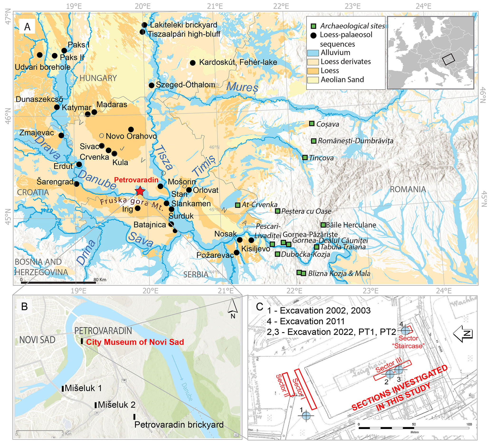
Figure 1(A) Map of the Vojvodina region with the geographical positions of the main loess sections (Lehmkuhl et al., 2018, modified), archaeological sites, and distribution of Quaternary sediments (Lehmkuhl et al., 2020). (B) Morphological map of the study area with position loess sections: Mišeluk 1, Mišeluk 2, and Petrovaradin brickyard, as well as the investigated site. (C) Detailed map of Petrovaradin Fortress with excavated sectors: 1 – excavation 2002–2003; 2,3 – excavation 2022 presented by the PT1 and PT2 sections (Mihailović et al, 2025); and 4 – excavation 2011 (Mihailović, 2009; Marković et al., 2021, modified).
2.1 Magnetic properties
Parallel samples (each 2.5 cm thick) from the PT1 and PT2 profiles were collected for low-field magnetic susceptibility (MS) analysis, packed in plastic cubes, and measured with a Bartington MS2 meter at the LAPER laboratory, Faculty of Sciences, University of Novi Sad.
2.2 Colourimetric measurements
Colour determinations were performed on samples taken at 2.5 cm intervals from the PT1 and PT2 profiles in the LAPER laboratory. The samples were dried in an oven for 12 h at 39 °C. Thereafter, the samples were ground using a mortar and pestle, and the colour reflectance of the loess and palaeosol samples was measured colourimetrically using a Konica Minolta Chroma Meter CR-400. Colour values were recorded in the CIE Lab* colour space, where L* represents lightness, and a* and b* are chromaticity coordinates: corresponds to the red direction, to green, to yellow, and to blue (Zeeden et al., 2015, 2017; Lukić et al., 2023; Laag et al., 2023). The conversion of L*, a*, b* values to RGB and the plotting of the results were performed following the method described by Sprafke et al. (2020).
2.3 Geochemical measurements
The sediment samples recovered at the PT1 and PT2 profiles (2.5 cm resolution) were hand-ground, air-dried, and compressed prior to analysis. Their chemical composition was determined using a Thermo Scientific XL2 NITON XRF analyser at the LAPER laboratory. We measured concentrations by weight for seven chemical elements (Zr, Sr, Rb, Fe, Mn, Ti, and Zn). The errors for Fe and Sr concentrations are less than ±5 %; for Zr and Rb, less than ±10 %; for Mn, less than ±15 %; and for Ti, less than ±25 %. These errors were calculated based on the internal instrument's error estimation without using reference samples. As these concentrations are only used to calculate element ratios, the dilution effect of other unmeasured elements and organic matter are not relevant here. Higher values of and ratios are used for indicating stronger pedogenesis and intensified chemical weathering (Buggle et al., 2011). This is a consequence of Rb and Zr being relatively immobile in this kind of environment, while Sr is highly mobile and easily weathered (Buggle et al., 2011).
2.4 Malacological analysis
Loess samples of 10 kg were taken continuously at 5 cm intervals from the studied section. In total, 22 samples were collected from two sub-profiles, PT1 and PT2. Clearly bioturbated parts of the section were avoided. The samples were left in distilled water overnight and then washed through a 0.5 mm sieve with running distilled water. The shells that remained on the sieve were manually picked and sorted using a dissecting stereomicroscope. Single apex, or a single aperture, are counted as one shell. If both the apex and aperture of the same species were found, they were counted as one shell. Classification of mollusc taxa according to their ecological preferences (temperature, humidity, and vegetation structure) was based on the interpretations of Ložek (1964), Sümegi and Krolopp (2002), Sysoev and Shileyko (2009), and Juřičková et al. (2014), as well as from previously published malacological data from the Serbian loess sequences (Radaković et al., 2023, 2024a, 2024b).
2.5 Radiocarbon dating
Radiocarbon dating of a charcoal sample found at depth of 45 cm in the PT1 profile was conducted at the A.E. Lalonde AMS Laboratory (Ottawa, Canada). Details on sample pretreatment techniques, processing methods, and media code definitions are provided in Crann et al. (2017) and Murseli et al. (2019). Radiocarbon analysis was performed using an Ionplus AG MICADAS (Mini Carbon Dating System). Calibration was carried out using OxCal v4.4 (Bronk Ramsey, 2009). The IntCal20 calibration curve was used (Reimer et al., 2020). Calibrated results are reported as ranges with associated probabilities, as point estimates (e.g. mean or median) cannot adequately represent the underlying uncertainties (Millard, 2014). While we acknowledge that point estimates are often requested, we recommend that published data tables report only calibrated age ranges.
3.1 Lithostratigraphy
The investigated profiles PT1 and PT2 show clear similarities with the three uppermost sedimentological units described by Marković et al. (2021) from a previously studied section investigated in 2011.
Unit I (0–20 cm depth at PT1, 0–12 cm depth at PT2) consists of homogeneous silt, pale-brown in the upper part and brown in the lower part. It is pebble free and contains numerous black spots, which represent organic matter trapped in former root pores. This unit resembles a weakly developed initial mollic horizon. The lower boundary is marked by angular blocks, occasionally up to 10 cm in diameter but mostly less than 5 cm (Fig. 2).
Unit II (20–30 cm depth at PT1, 12–32 cm depth at PT2) represents a transitional zone. It lacks black spots and contains dispersed pebbles, small carbonate concretions, and angular blocks up to 10 cm in diameter (Fig. 2).
Unit III (35–60 cm depth at PT1, 32–60 cm depth at PT2) is composed of pale-brown, poorly sorted, sandy coarse-grained silt containing carbonate concretions intercalated with darker, thin, weakly developed initial mollic horizons. It exhibits root fissures and lacks lamination. A discontinuous pebble layer is present at the base (Fig. 2).
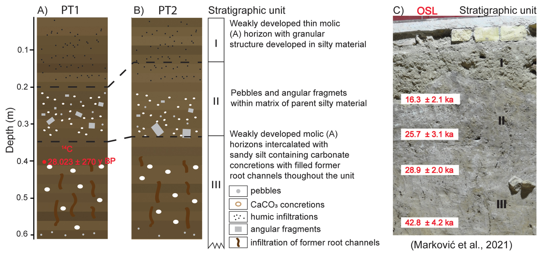
Figure 2Lithostratigraphy of (A) PT1 and (B) PT2 sections with (C) correlated stratigraphic units (adopted from Marković et al., 2021).
3.2 Magnetic susceptibility (MS)
The similarity in MS patterns between the PT1 and PT2 suggests a temporal correlation. Based on these similarities and on earlier investigations of the sediments in the City Museum of Novi Sad (Marković et al., 2021), we associated sediments from PT1 and PT2 to Unit I, II, and III from Marković et al. (2021). In Unit I of PT1 and PT2, the measured values are relatively low, ranging from 24 to 33 SI. Unit II is marked by an increase in the MS signal. In Unit III, which includes the basal parts of the investigated profiles, the MS values approach 40 SI (Fig. 3).
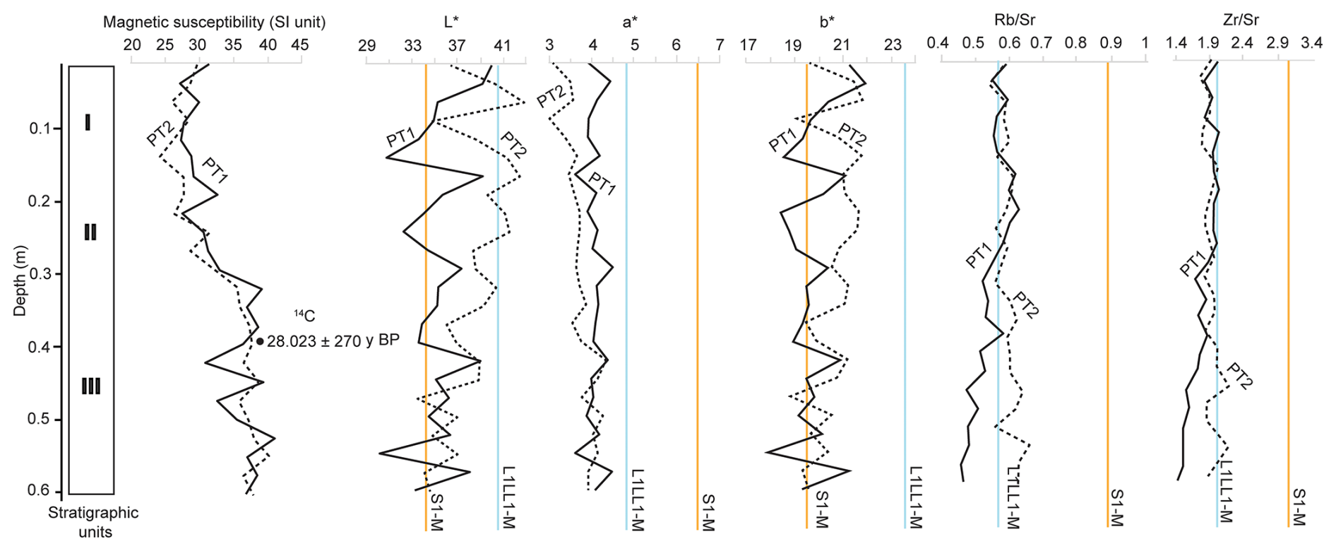
Figure 3Magnetic susceptibility (SI) of the PT1 (full black line) and PT2 (dashed black line) sections (data from Marković and Bosnić, 2026). The full black circle represents the 14C date of the sediment in the upper part of Unit III; colour measurement results of the PT1 and PT2 section, presented in L*, a*, and b* colour space; and and ratios of PT1 and PT2. Orange lines show the average value for pedocomplex S1-M, and the blue line represents the average value for the L1LL1-M loess unit of the nearby Mišeluk 2 loess-palaeosol sequence (Marković et al., 2025).
3.3 Colour
The measured colourimetric values and corresponding plots for profiles PT1 and PT2 are presented in Fig. 3. Both profiles exhibit similar trends in colour parameters. In profile PT1, Unit I shows a continuous decrease in lightness (L*) from 39.80 to 30.72 within the upper 15 cm of the section, indicating progressively darker sediment. Below this depth, the L* values increase, returning close to the initial surface value. The average L* value for Unit II is 34.62. In Unit III, the upper part is comparatively lighter, but the lightness decreases to a minimum of 30.13 at a depth of 52.5–55.0 cm, representing the darkest part of the profile. The red chromaticity coordinate (a*) shows relatively little variation throughout the PT1 profile. In Unit I, the average a* value is 3.99. This increases slightly to 4.15 in Unit II and then decreases to 4.01 in Unit III. The overall a* values range between 3.59 and 4.48. The yellow chromaticity coordinate (b*) displays trends similar to those observed for lightness. In Unit I, b* values decrease from 21.93 to 18.43, followed by a more stable trend in Unit II, where the average is 19.44. In Unit III, b* values again fluctuate, consistent with the variations seen in L*, with an average of 19.65 (Fig. 3).
In profile PT2, the highest L* values occur in Unit I, reaching up to 42.64, followed by a sharp decrease to 34.71, indicating a darker pedogenic layer. Beneath this, L* increases again to 42.26 and remains relatively stable throughout Unit II. However, a decline is observed in the lower part of Unit II, down to 35.92, at which point Unit III begins. Unit III is characterized by the lowest L* values in the profile (as low as 34.01), with minor oscillations towards the base, suggesting darker, more compacted material accumulated above the bedrock. The red chromaticity (a*) in PT2 generally follows a trend opposite to lightness. In Unit I, a* values are lower, with a minimum of 3.04, and then gradually increase in Unit II, where the trend stabilizes. In Unit III, the highest a* value of 4.35 is recorded, and elevated values persist throughout this unit compared to units I and II. The yellow component (b*) in PT2 broadly follows the lightness trend. Oscillations are seen in Unit I, where b* reaches a maximum of 21.79 and a minimum of 19.07. Below this, b* increases again and fluctuates around 21.00. In Unit III, b* values gradually decrease towards the bottom of the profile, indicating darker, more weathered sediment (Fig. 3).
Figure 3 also includes average L*, a*, and b* values from the nearby Mišeluk 2 section (Fig. 1). The yellow and blue reference lines in all three plots indicate the average colour values for the S1 pedocomplex and the L1LL1 loess unit, respectively. Based on L* values, PT1 sediments are more comparable to the Mišeluk pedocomplex, whereas PT2 is more similar to the L1LL1 unit, particularly in the middle stratigraphic layer. However, the S1 pedocomplex shows distinctly higher red chromaticity (a*), causing both PT1 and PT2 to align more closely with the L1LL1 loess in this respect. In contrast, b* values are lower in both Petrovaradin profiles, suggesting a closer affinity with the S1 pedocomplex.
3.4 Geochemistry
To evaluate the degree of weathering for the Petrovaradin Fortress loess, we employed two element ratios ( and ), which are widely used as weathering indices (e.g. Buggle et al., 2011). In Unit III, there are differences between PT1 and PT2 in and . This small difference may not be a consequence of higher weathering of PT2 and could reflect other sediment characteristics. In Unit II, these datasets start to have similar values and stay overlapped until the topmost part of both sections. Given that our measurements are obtained using specific methodology, they cannot be directly compared to geochemical datasets from other publications (see Krsmanović et al., 2025). Therefore, we compare the weathering index values with those from the Mišeluk 2 loess palaeosol sequence (LPS), which we calculated from the close-by Mišeluk 2 section (Fig. 1). Their proximity, along with the fact that both profiles are at similar elevations (Petrovaradin Fortress at 120 m a.s.l. and Mišeluk 2 at 136 m a.s.l.), suggests that they are likely characterized by similar (palaeo)environmental dynamics.
3.5 Radiocarbon dating
The charcoal sample (PT-3) yielded a conventional radiocarbon age of 23 895±7714C years BP (Table 1).
Table 1Radiocarbon dating results for a charcoal sample from the PT1 profile at Petrovaradin. Shown are the laboratory ID, sample ID, material type, and material code (following definitions in Crann et al., 2017), along with the conventional radiocarbon age (in years BP, with 1σ error), the measured fraction modern carbon (F14C ± 1σ), and the calibrated age range (cal BP at 95.4 % probability). Calibration was performed using OxCal v4.4 (Bronk Ramsey, 2009) and the IntCal20 calibration curve (Reimer et al., 2020).

Following the recommendations of Millard (2014), calibrated ages are presented as probability distributions rather than point estimates. Accordingly, the calibrated age range is 28 272–27 773 cal BP at 95.4 % probability. The dated material represents the timing of a charcoal-producing fire event, possibly related to palaeoenvironmental or anthropogenic activity (Fig. 3).
3.6 Malacology
A sampling resolution of 5 cm was essential for reconstructing palaeoenvironmental conditions relevant to Palaeolithic human occupation. The PT1 section yielded a total of 167 mollusc shells, representing seven species across six genera. Due to the fragility of Vallonia shells, particularly the frequent breakage of apertures in the upper part of PT1, not all specimens could be identified to species level. The number of shells per sample in PT1 ranged from 8 to 23. Both species richness and abundance tend to increase towards the top of the section. Among the identified taxa, Vitrea crystallina was the only species consistently present in all samples. This species, which is extant in the Vojvodina region of Serbia, typically inhabits riparian woodlands, leaf litter, humid meadows, and swampy environments (Gojšina et al., 2024; Welter-Schultes, 2012). Additional species commonly associated with loess deposits in Serbia were found, including Pupilla triplicata, Vallonia costata, Granaria frumentum, Clausilia dubia, Chondrula tridens, and Punctum pygmaeum.
In contrast, the PT2 section revealed a more abundant and taxonomically diverse mollusc assemblage (Fig. 4). Both species richness and abundance increase upwards through the profile, reaching a maximum of 119 shells and 12 species per sample. In total, 466 shells were recovered from PT2, comprising 12 species across 11 genera. Granaria frumentum constitutes approximately 25 % of the total assemblage and becomes increasingly dominant towards the end of the Late Pleniglacial. In contrast, Vallonia costata, Clausilia dubia, and Vitrea crystallina exhibit a marked decline in abundance.
The PT2 profile also contains several representatives of cold-adapted faunal elements, although they are relatively rare. These include Columella columella, Vertigo geyeri, and Vallonia tenuilabris. Their presence likely reflects climatic conditions during the Last Glacial Maximum (LGM; 29 to 19 ka, Hughes, 2022), when the Carpathian Basin experienced significantly colder temperatures. Although such taxa are rarely found in Serbian loess sequences (Radaković et al., 2024b), their occurrence serves as an important palaeoenvironmental indicator for MIS 2 (Sümegi et al., 2016). Environmental interpretations based on species composition were made using the classification frameworks of Sümegi and Krolopp (2002) and Ložek (1964), and are summarized in Fig. 5.
A comparison of the PT1 and PT2 sections reveals several common features. In both profiles, the majority of taxa are either tolerant of arid conditions or mesophilous in relation to moisture availability. Furthermore, in many samples, over 40 % of the assemblage consists of species that either prefer moderate environmental conditions or exhibit high ecological plasticity. A notable distinction between the two profiles is the presence of frigophilous (cold-adapted), cold-resistant, and sub-hygrophilous taxa in PT2. This suggests a more complex environment at the time of deposition, potentially consisting of a mosaic of habitats, including both forested and transitional zones between open and closed landscapes. Such a setting, likely associated with the Middle Pleniglacial, appears to have gradually evolved into a more open, steppe-like environment.
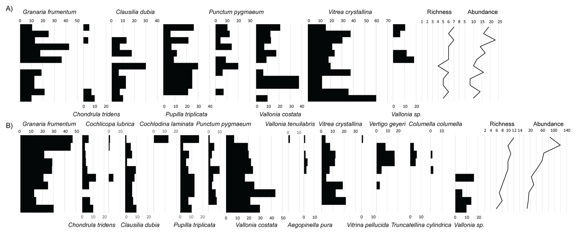
Figure 4The percentages of malacology at the (A) PT1 and (B) PT2 sections (data from Marković and Bosnić, 2026); richness and abundance indicated by black lines.
4.1 Chronostratigraphic interpretation
The approximately 0.6 m thick sedimentary sequence excavated in 2011 offers an opportunity to reconstruct environmental dynamics during the Late Pleniglacial and provides essential context for long-term human occupation around the Petrovaradin Fortress. Based on general lithostratigraphy, magnetic susceptibility, colour, and geochemical properties, as well as one radiocarbon date, it is possible to identify the equivalents of stratigraphic units I and II, and the upper part of III (Fig. 2). These units were originally defined by Marković et al. (2021) using luminescence dating during the first excavation campaign, which took place between 2002 and 2003 – a chronostratigraphic interpretation further supported by the magnetic record and radiocarbon date.
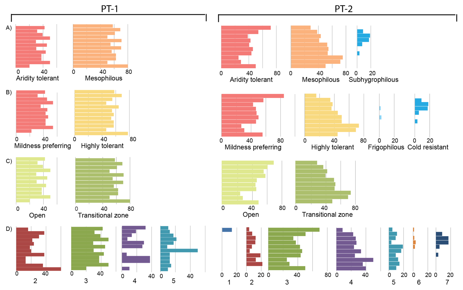
Figure 5The environmental interpretation of the PT1 and PT2 sections (data from Marković and Bosnić, 2026): (A) humidity; (B) temperature; (C) vegetation; and (D) habitat: 1. closed forest; 2. woodland environment generally – predominantly wooden biotope with locally open to completely open habitat (such as parks); 3. warm, dry grassland or rocky biotope on a substrate similar to rendzina or chernozem; 4. open habitats generally – from wet meadows to steppes, open habitats with possible park-like woodland, from xerothermic to partially semi-xerothermic habitats (open grounds); 5. open habitats and/or woodlands – various or species with a broad tolerance range; 6. open habitats and/or woodlands – predominantly moist habitats (near peat bogs or marshes) (damp); and 7. wet habitats, banks near aquatic environments and marshes (marshland, banks, very moist habitats).
The investigated sedimentary interval corresponds to the later part of MIS 3 and older part of MIS 2. A similar interpretation applies to the lower part of the L1LL1 loess unit and most likely the uppermost portion of the palaeosol unit L1SS1SSS1 at surrounding loess profiles Mišeluk and the Petrovaradin brickyard (Marković et al., 2004a, 2004b, 2005, 2021). This correlation is further supported by a simultaneous increase in magnetic susceptibility values observed in units II and III (this study), as well as beyond 2.25 m depth at the nearby Petrovaradin brickyard loess section (Marković et al., 2005). Finally, these findings are consistent with the general chronostratigraphic interpretations presented by Marković et al. (2004a, 2004b, 2005, 2021), even though the magnetic susceptibility dataset of the Petrovaradin brickyard section is less variable compared to PT1 and PT2 (Fig. 6).
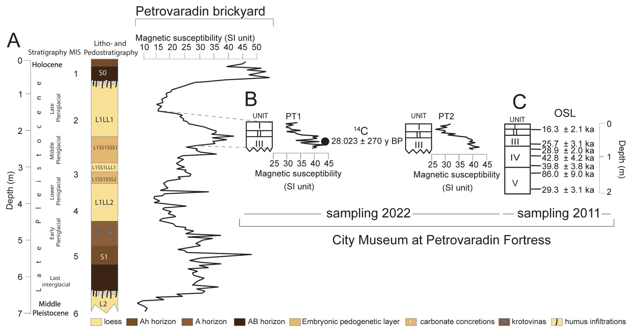
Figure 6Chronostratigraphic relation between (A) litho- and pedostratigraphy, and magnetic susceptibility variations at the Petrovaradin brickyard loess-palaeosol sequence (Marković et al., 2005); (B) stratigraphic units I, II, and III (upper part), and magnetic susceptibility records of profiles PT1 and PT2 (data from Marković and Bosnić, 2026) with the 14C date (this study); and (C) stratigraphic units from I to V defined by Marković et al. (2021) and associated with OSL ages (modified after Mihailović et al., 2025).
4.2 Environmental reconstruction
Additional environmental interpretations have been incorporated from the earlier study by Marković et al. (2021), which focused on excavations conducted between 2002 and 2003, as well as from adjacent loess sections at the Petrovaradin brickyard (Marković et al., 2005), Mišeluk 1 (Marković et al., 2004a), and Mišeluk 2 (Marković et al., 2025; see Fig. 1C). Based on sedimentological, magnetic, and geochemical evidence from the PT1 and PT2 profiles, the transitional interval between MIS2 and MIS3 appears to reflect relatively minor environmental variability compared to other central European sites from the same period (Vandenberghe et al., 1998; Rousseau, 2001; Frechen et al., 2003; Marković et al., 2008, 2015; Sprafke et al., 2020). For better illustration of environmental differences between the western- and central European loess belt, and the Vojvodina loess province, see Fig. 8 in Marković et al. (2018). These interpretations are also consistent with comparable results from nearby loess- palaeosol sequences at the Petrovaradin brickyard and the Mišeluk 1 (Marković et al., 2004a) and Mišeluk 2 (Marković et al., 2025) sites, based on sedimentary, magnetic, and geochemical data, as well as fossil land snail assemblages. Another proof that these sediments belong to the glacial period comes from weathering indices and colour analysis. Colour insight provides a preliminary basis for distinguishing whether the investigated samples are more characteristic of pedogenic or loessic material. In terms of lightness, PT1 values generally correspond to the S1 pedocomplex at Mišeluk, except for the uppermost part of Unit I, which resembles the L1LL1 loess. In contrast, the PT2 lightness values are higher and align more closely with the L1LL1 loess. In terms of and values (Fig. 3), PT1 and PT2 sediments align better with the Late Pleniglacial sediments of Mišeluk 2 than with the S1 pedocomplex. Also, the values of for PT1 and PT2 sediments match with values of weakly weathered loess units from Batajnica LPS (Buggle et al., 2011). Therefore, weathering is not pronounced throughout both PT1 and PT2.
Molluscs are generally not found in the interglacial palaeosols which developed in the southeastern Carpathian Basin (Radaković et al., 2023, 2024a, 2024b), thus finding the shells continuously through the PT1 and PT2 sections makes them more likely to be accumulated over part of the glacial period where soil formation was insufficient or lacking.
The presence of Columella columella, Vertigo geyeri, and Vallonia tenuilabris likely reflects climatic conditions during the Last Glacial Maximum (LGM; 29 to 19 ka, Hughes, 2022), when the Carpathian Basin experienced significantly colder temperatures. Although such taxa are rarely found in Serbian loess sequences (Radaković et al., 2024b), their occurrence serves as an important palaeoenvironmental indicator for MIS 2 (Sümegi et al., 2016). Environmental interpretations based on species composition were made using the classification frameworks of Sümegi and Krolopp (2002) and Ložek (1964), and are summarized in Fig. 5.
Given the environmental complexity revealed by the malacological data from Petrovaradin, we recommend the excavation and sampling of multiple profiles at archaeological sites. This approach is essential to capture the full range of palaeoenvironmental conditions that Palaeolithic populations may have encountered.
The identified mollusc assemblages indicate that the investigated area experienced more humid environmental conditions during the last glacial period than other parts of the southeastern Carpathian Basin (Marković et al., 2007; Sümegi et al., 2016; Gavrilović et al., 2020). As a result, the northern slope of Fruška Gora Mountain (539 m elevation; 45°09′04" N, 19°42′40" E; see Fig. 1) likely served as a biogeographical “island” and a glacial refugium, where certain forest elements were able to persist (Marković et al., 2004a, 2005, 2008).
The Middle Pleniglacial pedocomplex L1SS1 is weakly developed at the Petrovaradin brickyard and Mišeluk sites, and is interpreted as forming under a temperate, warm, and relatively dry climate. In contrast, data from the Late Pleniglacial loess unit L1LL1 indicate the coldest and most humid conditions of the last glacial cycle (Marković et al., 2004a, 2004b, 2005, 2008, 2021). These findings suggest that the southeastern Carpathian Basin was an area of comparatively stable palaeoclimatic conditions during much of the last glacial period, especially in contrast to other loess regions of Europe.
However, they also highlight important differences in the malacofaunal assemblages between the PT1 and PT2 profiles. Profile PT1 is dominated by taxa associated with open grassland environments, with a clear predominance of mildness-tolerant and ecologically flexible species. No cold-resistant or frigophilous taxa were identified in this profile. In contrast, malacofauna from PT2 reflect a more humid environment, evidenced by a higher total abundance of snail shells and the presence of more forest-dwelling species. In the upper part of PT2, cold-adapted and cold-resistant taxa such as Columella columella and Vallonia tenuilabris were identified, most likely indicating conditions associated with the Last Glacial Maximum (LGM). These results suggest that the study area was characterized by heterogeneous, mosaic-like parkland vegetation. It is likely that elevated July palaeotemperatures facilitated brief dry periods during the short glacial summer seasons. The high degree of environmental heterogeneity observed over short spatial scales may have played an important role in sustaining long-term human occupation in the region.
4.3 Archaeological context
The Petrovaradin rock formation, a dominant feature of the palaeolandscape, provided highly favourable conditions for prehistoric habitation. Its elevated position at the junction of several geomorphological units (mountain, river terrace, alluvial plain) offered expansive visibility over the surrounding terrain, which was advantageous for monitoring wildlife and facilitating hunting activities. The northern slopes of Fruška Gora Mountain at that time were less steep, as the Danube was flowing more north than it is today (Marković et al., 2021). This open terrain is similar to that occupied by Palaeolithic humans in northern Greece during the last glacial period (see Allard et al., 2020, their Fig. 11 and references therein), and it appears that such landscapes were a common factor promoting human habitation across the Balkans. Furthermore, the presence of nearby white flint deposits, which were extensively exploited during the Middle and Upper Palaeolithic, added to the site's appeal for sustained human settlement (Mihailović et al., 2025).
During the Middle Palaeolithic, abundant artefacts, evidence of on-site tool production, and a high proportion of domestic tools all indicate extended habitation at the Petrovaradin Fortress (Mihailović, 2009, 2022, 2025). However, the time frame of formation of the PT1 and PT2 profiles generally corresponds to the Upper Palaeolithic period, contemporaneous with numerous Gravettian sites in the northern Balkans. This supports the idea that Gravettian populations were concentrated in the southern Pannonian Basin and adjacent areas prior to the Last Glacial Maximum (LGM). The lithic assemblages from the Upper Palaeolithic layer at Petrovaradin correspond to the “technologically impoverished” industries typical of the Late Gravettian and Early Epigravettian.
This study presents multiproxy investigation of the last glacial sedimentary sequence at the Petrovaradin Fortress, in Vojvodina, Serbia. During the Middle Palaeolithic occupation, the slope between the Petrovaradin rock and the Danube River was gentler than the current steep cliff. Additionally, the Danube River was also located further to the north in comparison to its modern location (Marković et al., 2021). Nevertheless, it was still a highly strategic position for a Palaeolithic site surrounded by high environmental diversity associated with existing palaeorelief conditions. The relative environmental stability identified in the investigated area during the last glacial period is likely also a key factor in human occupation. In previous studies, the northern slopes of Fruška Gora Mountain were described as a biogeographical “island” during the Last Glacial Maximum (Marković et al., 2004a, 2005, 2008, 2021). This study supports this idea, and, based on mollusc assemblages found in PT1 and PT2, the evidence shows the coexistence of different mosaic biotopes over a relatively small area with the sporadic presence of forest elements. A better understanding of refugium at northern slopes of Fruška Gora Mountain requires further detailed malacological investigations.
Data from PT1 and PT2 are available online at https://doi.org/10.5281/zenodo.18268625 (Marković and Bosnić, 2025). Data from Mišeluk 2 are available online at https://doi.org/10.5281/zenodo.17334484 (Marković et al., 2025).
SBM, DM, MR, and ZMP formulated the overarching research goals and aims, and are responsible for the acquisition of financial support for the project, leading to this publication. SBM, DM, MGB, AP, DP, RSM, and JK conducted the sample collection. MGB, TL, PK, AP, JK, DP, QH, LW, and RSM analysed and synthesized magnetic, colour, and geochemistry data. MK, AK, AR, VS, LB, and CZ conducted the sample collection. SBM and DM managed and coordinated the research activity. SBM, DM, and MR supervised the research activity. MGB, PK, and SBM conducted the data visualization. SBM, MGB, and ZMP wrote the original draft of the paper, with contributions from all co-authors. PDH, QH, LW, and ZMP reviewed the original draft of the article before the initial submission, and added comments and revisions.
The contact author has declared that none of the authors has any competing interests.
Publisher's note: Copernicus Publications remains neutral with regard to jurisdictional claims made in the text, published maps, institutional affiliations, or any other geographical representation in this paper. The authors bear the ultimate responsibility for providing appropriate place names. Views expressed in the text are those of the authors and do not necessarily reflect the views of the publisher.
We are grateful to the management of the Novi Sad City Museum at the Petrovaradin Fortress for logistic support during the excavations.
This research has been supported by the Kungliga Fysiografiska Sällskapet i Lund (grant nos. 42788 and 43046), the Serbian Academy of Sciences and Arts (grant no. F-178), the Ministarstvo Prosvete, Nauke i Tehnološkog Razvoja (grant nos. 451-03-65/2024-03/200123, 451-03-66/2024-03/ 200125, 451-03-66/2024-03/ 200163, and 451-03-65/2024-03/200125), the Science Fund of the Republic of Serbia (grant nos. LAMINATION (17807) and NEEMO (7746827)), the Natural Sciences and Engineering Research Council of Canada, Networks of Centres of Excellence of Canada (grant no. RGPIN-2019-04113), and the Social Sciences and Humanities Research Council of Canada, Networks of Centres of Excellence of Canada (grant no. 895-2024-1005).
The publication of this article was funded by the Swedish Research Council, Forte, Formas, and Vinnova.
This paper was edited by Julia Meister and Christian Zeeden and reviewed by two anonymous referees.
Allard, J. L., Hughes, P. D., Woodward, J. C., Fink, D., Simon, K., and Wilcken, K. M.: Late Pleistocene glaciers in Greece: A new 36Cl chronology, Quat. Sci. Rev., 245, 106528, https://doi.org/10.1016/j.quascirev.2020.106528, 2020.
Buggle, B., Glaser, B., Hambach, U., Gerasimenko, N., and Marković, S.: An evaluation of geochemical weathering indices in loess–paleosol studies, Quat. Int., 240, 12–21, https://doi.org/10.1016/j.quaint.2010.07.019, 2011.
Chu, W., Lengyel, G., Zeeden, C., Péntek, A., Kaminská, L'., and Mester, Z.: Early Upper Paleolithic surface collections from loess-like sediments in the northern Carpathian Basin, Quat. Int., 485, 167–182, https://doi.org/10.1016/j.quaint.2017.06.018, 2018.
Crann, C. A., Murseli, S., St-Jean, G., Zhao, X., Clark, I. D., and Kieser, W. E.: First status report on radiocarbon sample preparation techniques at the AE Lalonde AMS Laboratory (Ottawa, Canada), Radiocarbon, 59, 695–704, https://doi.org/10.1017/RDC.2016.56, 2017.
Frechen, M., Oches, E. A., and Kohfeld, K. E.: Loess in Europe-mass accumulation rates during the Last Glacial Period, Quat. Sci. Rev., 22, 1835–1857, https://doi.org/10.1016/S0277-3791(03)00140-6, 2003.
Gavrilović, B., Sümegi, P., Ćirić, M., Radaković, M. G., Gavrilov, M. B., Mladjen, D., and Marković, S. B.: The Middle and Late Pleniglacial (Weichselian) malacofauna of the Zemun loess–paleosol sequence, Serbia, PalZ, 1–13, https://doi.org/10.1007/s12542-024-00663-8, 2020.
Gojšina, V., Vesović, N., Ćurčić, S., Karan-Žnidaršič, T., Mitrović, B., and Dedov, I.: A review of the genus Vitrea Fitzinger, 1833 (Gastropoda, Eupulmonata, Pristilomatidae) in Serbia: diversity, distribution and the description of a new species, ZooKeys, 1200, 245–269, https://doi.org/10.3897/zookeys.1200.111097, 2024.
Hughes, P. D.: Concept and global context of the glacial landforms from the Last Glacial Maximum, in: European Glacial Landscapes, 355–358, Elsevier, https://doi.org/10.1016/B978-0-12-813134-4.00019-4, 2022.
IUSS Working Group WRB: World Reference Base for Soil Resources. International soil classification system for naming soils and creating legends for soil maps, 4th edn., International Union of Soil Sciences (IUSS), Vienna, Austria, https://files.isric.org/public/documents/WRB_fourth_edition_2022-12-18.pdf (last access: 11 March 2026), 2022.
Juřičková, L., Ložek, V., Horáčková, J., Tlachač, P., and Horáček, I.: Holocene succession and biogeographical importance of mollusk fauna in the Western Sudetes (Czech Republic), Quat. Int., 353, 210–224, https://doi.org/10.1016/j.quaint.2013.07.012, 2014.
Krsmanović, P., Perić, Z. M., Thompson, W., Radaković, M. G., Ryan, C. S., Schaetzl, R. J., Hao, Q., Lukić, T., Alexanderson, H., and Marković, S. B.: Loess provenance in the westernmost part of the lower Danube Basin, Serbia: Geochemical insights from the Velika Vrbica fluvial–eolian section, Quat. Int., 748, 109969, https://doi.org/10.1016/j.quaint.2025.109969, 2025.
Laag, C., Lagroix, F., Kreutzer, S., Chapkanski, S., Zeeden, C., and Guyodo, Y.: Measuring and evaluating colorimetric properties of samples from loess-paleosol sequences, MethodsX, 10, 102159, https://doi.org/10.1016/j.mex.2023.102159, 2023.
Lehmkuhl, F., Bösken, J., Hošek, J., Sprafke, T., Marković, S. B., Obreht, I., and Lindner, H.: Loess distribution and related Quaternary sediments in the Carpathian Basin, J. Maps, 14, 661–670, https://doi.org/10.1080/17445647.2018.1527404, 2018.
Lehmkuhl, F., Nett, J., Pötter, S., Schulte, P., Sprafke, T., Jary, Z., Antoine, P., Wacha, L., Wolf, D., Zerboni, A., Hošek, J., Marković, S., Sümegi, P., Veres, D., Zeeden, C., Boemke, B., Schaubert, V., Viehweger, J., and Hambach, U.: Geodata of European loess domains, CRC806-Database [data set], https://doi.org/10.5880/SFB806.58, 2020.
Ložek, V.: Quartärmollusken der Tschechoslowakei, Geol. Zentr. Veröff., 31, 1–374, 1964.
Lukić, T., Radaković, M., Marković, R., Thompson, W., Micić Ponjiger, T., Basarin, B., Tomić, N., Tomović, V., Popov Raljić, J., and Gavrilov, M.: Initial results of the colourimetric indices of the oldest exposed pedocomplex (Titel loess plateau, Serbia), Geol. Croat., 76, 73–85, https://doi.org/10.4154/gc.2023.17, 2023.
Marković, S. and Bosnić, M.: City Museum of Novi Sad (Petrovaradin) Loess palaeosol sequences PT1 and PT2, Serbia (XRF, COLOR, MS, SHELLS), Zenodo [data set], https://doi.org/10.5281/zenodo.18268625, 2026.
Marković, S., Bosnić, M., Marković, R., Krsmanović, P., Kolundžija, J., Pilipović, A., and Puhar, D.: Mišeluk 2 loess palaeosol sequence, Serbia (XRF, COLOR), Zenodo [data set], https://doi.org/10.5281/zenodo.17334484, 2025.
Marković, S. B., Oches, E. A., Jovanović, M., Gaudenyi, T., Hambach, U., Zöller, L., and Sümegi, P.: Paleoclimate record in the Late Pleistocene loess-paleosol sequence at Mišeluk (Vojvodina, Serbia), Quaternaire, 15, 361–368, 2004a.
Marković, S. B., Mihailović, D., Oches, E. A., Jovanović, M., and Gaudenyi, T.: The last glacial climate, environment and evidence of palaeolithic occupation in Vojvodina province, Serbia: an overview, Antaeus, 26, 307–317, 2004b.
Marković, S. B., McCoy, W. D., Oches, E. A., Savić, S., Gaudenyi, T., Jovanović, M., Stevens, T., Walther, R., Ivanišević, P., and Galović, Z.: Paleoclimate record in the Late Pleistocene loess-paleosol sequence at Petrovaradin Brickyard (Vojvodina, Serbia), Geol. Carpath., 56, 483–491, 2005.
Marković, S. B., Oches, E. A., McCoy, W. D., Gaudenyi, T., and Frechen, M.: Malacological and sedimentological evidence for “warm” climate from the Irig loess sequence (Vojvodina, Serbia), Geophys. Geochem. Geosyst., 8, Q09008, https://doi.org/10.1029/2007GC001724, 2007.
Marković, S. B., Bokhorst, M. P., Vandenberghe, J., McCoy, W. D., Oches, E. A., Hambach, U., Gaudenyi, T., Jovanović, M., Zöller, L., and Stevens, T.: Late Pleistocene loess-paleosol sequences in the Vojvodina region, North Serbia, J. Quat. Sci., 23, 73–84, https://doi.org/10.1002/jqs.1128, 2008.
Marković, S. B., Stevens, T., Kukla, G. J., Hambach, U., Fitzsimmons, K. E., Gibbard, P., Buggle, B., Zech, M., Guo, Z., and Hao, Q.: The Danube loess stratigraphy – new steps towards the development of a pan-European loess stratigraphic model, Earth Sci. Rev., 148, 228–258, https://doi.org/10.1016/j.earscirev.2015.06.005, 2015.
Marković, S. B., Sümegi, P., Stevens, T., Schaetzl, R. J., Obreht, I., Chu, W., Buggle, B., Zech, M., Zech, R., Zeeden, C., Gavrilov, M. B., Perić, Z., Svirčev, Z., and Lehmkuhl, F.: The Crvenka loess-paleosol sequence: A record of continuous grassland domination in the southern Carpathian Basin during the Late Pleistocene, Palaeogeogr. Palaeoclimatol. Palaeoecol, 509, 33–46, https://doi.org/10.1016/j.palaeo.2018.03.019, 2018.
Marković, S. B., Vandenberghe, J., Stevens, T., Mihailović, D., Gavrilov, M. B., Radaković, M. G., Zeeden, C., Obreht, I., Perić, Z. M., and Nett, J. J.: Geomorphological evolution of the Petrovaradin Fortress Palaeolithic site (Novi Sad, Serbia), Quat. Res., 103, 21–34, https://doi.org/10.1017/qua.2021.4, 2021.
Markovic, S., Bosnić, M., Marković, R., Krsmanović, P., Kolundžija, J., Pilipović, A., and Puhar, D.: Mišeluk 2 loess palaeosol sequence, Serbia (XRF, COLOR), Zenodo [data set], https://doi.org/10.5281/zenodo.17334484, 2025.
Mihailović, D.: Middle Palaeolithic Settlement at Petrovaradin Fortress. Petrovaradin Edition, Vol. II, The City Museum of Novi Sad, Novi Sad, https://www.academia.edu/1176665/Mihailovic_D_2009_Middle_Palaeolithic_Settlement_at_Petrovaradin_Fortress_Petrovaradin_Edition_Vol_II_The_City_Museum_of_Novi_Sad_Novi_Sad (last access: 11 March 2026), 2009.
Mihailović, D., Marković, S. B., Kuhn, S. L., Dragosavac, S., Mihailović, B., and Roksandić, M.: Middle and Upper Paleolithic of the southern Pannonian Basin: lithic assemblages from Petrovaradin Fortress (Novi Sad, Serbia), Quat. Int., 746, 109950, https://doi.org/10.1016/j.quaint.2025.109950, 2025.
Millard, A. R.: Conventions for reporting radiocarbon determinations, Radiocarbon, 56, 555–559, https://doi.org/10.2458/56.17455, 2014.
Murseli, S., Middlestead, P., St-Jean, G., Zhao, X., Jean, C., Crann, C. A., Kieser, W. E., and Clark, I. D.: The preparation of water (DIC, DOC) and gas (CO2, CH4) samples for radiocarbon analysis at AEL-AMS, Ottawa, Canada, Radiocarbon, 61, 1563–1571, https://doi.org/10.1017/RDC.2019.137, 2019.
Nett, J. J., Chu, W., Fischer, P., Hambach, U., Klasen, N., Zeeden, C., Obreht, I., Obrocki, L., Pötter, S., and Gavrilov, M. B.: The Early Upper Paleolithic Site Crvenka-At, Serbia–The First Aurignacian Lowland Occupation Site in the Southern Carpathian Basin, Front. Earth Sci., 9, 599986, https://doi.org/10.3389/feart.2021.599986, 2021.
Radaković, M. G., Oches, E. A., Hughes, P. D., Marković, R. S., Hao, Q., Perić, Z. M., Gavrilović, B., Ludwig, P., Lukić, T., Gavrilov, M. B., and Marković, S. B.: Reconstructed malacothermometer July paleotemperatures from the last nine glacials over the South-Eastern Carpathian Basin (Serbia), Atmosphere, 14, 791, https://doi.org/10.3390/atmos14050791, 2023.
Radaković, M. G., Gavrilović, B., Gavrilov, M. B., Marković, R. S., Hao, Q., Schaetzl, R. J., Zeeden, C., Cai, B., Perić, Z. M., Antić, A., Lukić, T., and Marković, S. B.: A Glacial – Interglacial Malacofauna Record from the Titel Loess Plateau, Serbia, between ∼350 and 250 ka, Quaternary, 7, 28, https://doi.org/10.3390/quat7020028, 2024a.
Radaković, M. G., Gavrilović, B., and Marković, S.: Changes in the diversity of loess mollusks in Serbia during the last nine ice ages, Geoconcept J., 1, 103–115, 2024b.
Ramsey, C. B.: Bayesian analysis of radiocarbon dates, Radiocarbon, 51, 337–360, https://doi.org/10.1017/S0033822200033865, 2009.
Reimer, P. J., Austin, W. E., Bard, E., Bayliss, A., Blackwell, P. G., Ramsey, C. B., Butzin, M., Cheng, H., Edwards, R. L., and Friedrich, M.: The IntCal20 Northern Hemisphere radiocarbon age calibration curve (0–55 cal kBP), Radiocarbon, 62, 725–757, https://doi.org/10.1017/RDC.2020.41, 2020.
Rousseau, D. D.: Loess biostratigraphy: new advances and approaches in mollusk studies, Earth-Sci. Rev., 54, 157–171, https://doi.org/10.1016/S0012-8252(01)00045-1, 2001.
Sprafke, T., Schulte, P., Meyer-Heintze, S., Händel, M., Einwögerer, T., Simon, U., Peticzka, R., Schäfer, C., and Lehmkuhl, F.: Paleoenvironments from robust loess stratigraphy using high-resolution colour and grain-size data of the last glacial Krems-Wachtberg record (NE Austria), Quat. Sci. Rev., 248, 106602, https://doi.org/10.1016/j.quascirev.2020.106602, 2020.
Sümegi, P. and Krolopp, E.: Quatermalacological analyses for modeling of the Upper Weichselian palaeoenvironmental changes in the Carpathian Basin, Quat. Int., 91, 53–63, https://doi.org/10.1016/S1040-6182(01)00099-7, 2002.
Sümegi, P., Marković, S. B., Molnár, D., Sávai, S., Náfrádi, K., Szelepcsényi, Z., and Novák, Z.: Črvenka loess-paleosol sequence revisited: local and regional Quaternary biogeographical inferences of the southern Carpathian Basin, Open Geosci., 8, 390–404, https://doi.org/10.1515/geo-2016-0031, 2016.
Sysoev, A. and Shileyko, A.: Land snails and slugs of Russian and adjacent countries, Pensoft Publ., Sofia – Moscow, 312 pp., https://dokumen.pub/land-snails-and-slugs-of-russia-and-adjace nt-countries-faunistica-9546424749-9789546424747.html (last access: 11 March 2026), 2009.
Vandenberghe, J., Huijzer, B. S., Mücher, H., and Laan, W.: Short climatic oscillations in a western European loess sequence (Kesselt, Belgium), J. Quat. Sci., 13, 471–485, https://doi.org/10.1002/(SICI)1099-1417(1998090)13:5<471::AID-JQS415>3.0.CO;2-V, 1998.
Welter-Schultes, F. W.: European non-marine molluscs, a guide for species identification, Planet Poster Editions, 1–679, https://www.pemberleybooks.com/product/european-non-marin e-molluscs-a-guide-for-species-identification/23712/ (last access: 11 March 2026), 2012.
Wilson, L.: The role of geoarchaeology in extending our perspective, Geological Society of London, https://doi.org/10.1144/SP352.1, 2011.
Zeeden, C., Hilgen, F., Röhl, U., Seelos, K., and Lourens, L.: Sediment color as a tool in cyclostratigraphy – a new application for improved data acquisition and correction from drill cores, Newsl. Stratigr., 48, 277–285, https://doi.org/10.1127/nos/2015/0064, 2015.
Zeeden, C., Krauß, L., Kels, H., and Lehmkuhl, F.: Digital image analysis of outcropping sediments: Comparison to photospectrometric data from Quaternary loess deposits at Şanoviţa (Romania) and Achenheim (France), Quat. Int., 429, 100–107, https://doi.org/10.1016/j.quaint.2016.02.047, 2017.